Showing 4487 items
matching cities and towns
-
 Kiewa Valley Historical Society
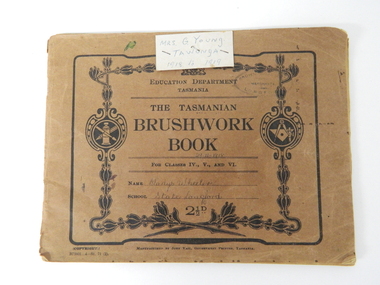
Book - Sketch Book, Circa 1918
This childhood sketchbook of the 1918 era details the emphasis placed upon a skill of brushwork that portrayed part of the students natural environment both in Tasmanian schools and Victorian schools, especially rural schools. The close bondage between students and their environment was a reflection on the early "hands on" approach in child education. Abstract art or teaching aids which could not be identified with physical properties available to students at this period in time were of lesser value. The ability of the student to identify the artistic value of local nature eg. local plants and flowers was especial important to rural based school children who had limited excursion opportunities available to visit town/city based botanical gardens and museums. This brushwork book is very significant to the Kiewa Valley as it demonstrates that childhood relocations from one State to another were not detrimental to the students overall scholastic development. The rural environment in Tasmania was not that far removed from the rural environment of the Kiewa Valley. The skills taught in both regions were still the same and the socio-economic factors and mores were also similar. This item demonstrates the relocation of one family from Tasmania to the Kiewa Valley. The expansion in population into the Kiewa valley was quite erratic and significant population growth only came after the increase in population brought into the area by the SEC Vic Hydro Scheme introduced to quench the demand for Victoria's electricity.This book has a brown cover with black print and designs on a 150 gsm cardboard. Each page is of the same thickness as the cover but is of paper.On the outside cover and contained within a thick boarder. "EDUCATION DEPARTMENT" and below this in smaller print "TASMANIA" below this "THE TASMANIAN BRUSHWORK BOOK". Below this "FOR CLASSES IV., V., AND VI" Below this "NAME" SCHOOL" At the bottom 2 1/2d1918's educational sketchbook, 1918 children's sketchbook -
 Warrnambool and District Historical Society Inc.
Document - Ledger, Leahy's Electrical Industries Committee, Circa mid 20th century
J. J. Leahy set up his retail electrical business in 1946 selling fridges, stoves and washers after commencing work wiring peoples’ homes in the late 1940’s. He developed the business into a large retail store and electrical contracting business which operated locally and Australia wide... He also ran Beattie and Phillips Funeral directors. The electrical business had several locations along Koroit Street before finally establishing on the south east corner of Fairy and Koroit Street. Jim died in November 26th 2008. The store is still run by his nephew Robert Askew. Jimmy Leahy was involved in the City council for a number of years and served as town mayor. The minutes contained in this book especially the information written in the Managing directors reports, provides an overview not just of a business but of business practice and the changes which occurred in life over the 40 year period. It contains events such as the introduction of television, refrigerated dairies and dates for tenders for major building programs such as WIAE, East Warrnambool School, Town Hall. Large dark blue fabric and leather bound ledger. The index pages are A –Z but contain no entries. Pages 1- 108 are handwritten minutes of Leahy’s Electrical Industries Committee. Pages 109-114 contain typed pages re AGM. Remaining pages are blank. Time period ranges from March 28th 1951 to December 1986. Signatures: J B Dwyer, W J Gleeson J J Leahy. Names included J.B. Dwyer, J.J. Leahy, M White, W.W. Croft, J.J. Walter, W Ross, J.J. Affleck, C.A. Richards, S J Wilson, J Croft, I.L. T Mahoney, P Conheady, J Meade.warrnambool, j.j. leahy, leahy’s, jimmy leahy, ledger, leahy’s electrical -
 Warrnambool and District Historical Society Inc.
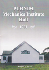
Booklet, Ron Best, Purnim Mechanics Institute Hall 1901, 2014
Brief history of Purnim Mechanics Institute HallThis is a paper back book of 24 pages. It has a white back cover and a grey/white front cover with a coloured photograph of the second Purnim Hall. The printed material is black on a white background. non-fictionBrief history of Purnim Mechanics Institute Hallpurnim, mechanics’ institutes, warrnambool -
 Glen Eira Historical Society
Document - Memorials in Glen Eira
This file contains one item: 1/A printout from the Victorian Memorials Database, undated and researcher unknown, containing records of 9 memorials in the Caulfield City municipality. These memorials are: - Caulfield Grammar School Site Pavement Marker, Elsternwick - Monument to racehorse ‘Jackstaff’ in Caulfield Racing Museum. - Rosstown Railway Marker, Bambra Road, Caulfield. - Thomas Alexander Browne Grave, Brighton Cemetery. - Grave of Sir John and Lady Monash, Brighton Cemetery. - Frederick Jowett Memorial Drinking Fountain, Caulfield Town Hall - Adam Lindsay Gordon Grave, Brighton Cemetery. - Jewish victims of World War 2 Memorial, Kadimah Centre, Elsternwick. - Hopetown Gardens Cannon, Elsternwick.historical markers, caulfield city, caulfield grammar school, elsternwick, regent street, caulfield racing museum, rosstown railway marker, caulfield, bambra road, curraweena road, marara road, city of caulfield, mayors, councillors, caulfield historical society, rosstown railway, caulfield grammar school pavement marker, monument to racehorse ‘jackstaff’, ross murray, browne thomas alexander, thomas alexander browne grave, brighton cemetery, rolf boldrewood, north road, caulfield south, browne margaret maria, grave of sir john and lady monash, monash john sir, monash hannah victoria lady, frederick jowett memorial drinking fountain, caulfield town hall, hawthorn road, glen eira road, jowett frederick, borough of caulfield, adam lindsay gordon grave, gordon adam lindsay, gordon annie lindsay, jewish victims of world war 2 memorial, kadimah jewish cultural centre and library, selwyn street, burston seddon, hopetoun gardens cannon, glenhuntly road, glen huntly road, schools, historic sites, plaques, footpaths, horseracing, horses, jackstaff, monuments and memorials, railways, authors, cemeteries, graves, gravestones, jewish community, town clerks, shire secretaries, town hall, drinking taps, poetry, children, libraries, world war 1939 – 1945, hopetoun, cannons, festivals and celebrations -
 Eltham District Historical Society Inc
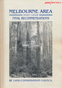
Book, Land Conservation Council, Melbourne Area, District 2 Review: Final Recommendations, 1994
Notices showing the boundary of the area of the review and advising that an investigation was to be carried out were published in the Victoria Government Gazette and in local and other Victorian newspapers in May 1987. A descriptive resources report was published in August 1991. Council received 1,425 submissions and letters following publication of the descriptive report. The Council considered these submissions and published proposed recommendations in April 1993. A further 1,993 submissions were received in response to the proposed recommendations. The Council published its final recommendations in July 1994. A change to legislation in 1989 enabled the LCC to make recommendations for public land within a ‘town’, though cities and rural cities remained excluded from the definition of public land. Timber resources and water quality and yield from timbered catchment areas remained significant issues in Melbourne’s catchments. Recommendations for the Yarra Ranges National Park were based around the closed Melbourne water catchments and adjoining state forest. A recommended Phillip Island State Park based around the penguin reserve was ultimately implemented as the Phillip Island Nature Park.Shire of Nillumbik DPE/Enviro -
 Bayside Gallery - Bayside City Council Art & Heritage Collection
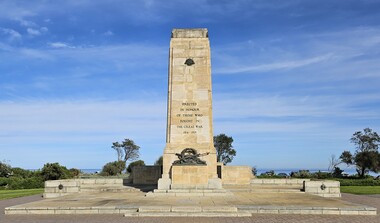
Monument - Memorial, Irwin and Stevenson, Brighton War Memorial, 1927
On 23 July 1922, Brighton City Council adopted the recommendation from a sub-committee that the site for a war memorial be at Green Point, Brighton Beach. Brighton Council invited designs, limited to returned soldier architects and 18 designs were received. The first prize of £30 was awarded to the architecture firm Irwin and Stevenson and the designs were exhibited at the Brighton Town Hall in 1925. The bronze casting, using lost wax technique, was executed by sculptor Mr. Paul Montford, to the design of the architect and the central assemblage was believed to be the largest bronze casting in relief carried out in Australia at the time. The Brighton War Memorial was unveiled by His Excellency the Governor, the Right Honourable Arthur Herbert Tennyson Baron Somers, K.C.M.G., D.S.O., M.C., on Sunday 24th April 1927 in the presence of 4,000 people. The memorial was originally constructed to commemorate those from the City of Brighton who served in World War One but has since been augmented to commemorate those from the municipality of Bayside who have made the ultimate sacrifice during official periods of hostility.War memorial consisting of a sandstone cenotaph, granite base and sandstone terrace situated at Green Point, Brighton. The cenotaph is a truncated obelisk with classical decoration in stone and bronze. The cenotaph bears the Rising Sun badge in bronze relief near its top with bronze lettering running down the cenotaph reading "ERECTED IN HONOUR OF THOSE WHO FOUGHT IN THE GREAT WAR 1914 – 1919". A bronze relief assemblage of crossed weapons, a wreath, the lamp of valour and the Latin phrase "DUCIT AMOR PATRIA" (love of country leads me) sit above the base which is carved with the word "SERVICE". The terrace walls have bronze relief medallions with images of the head of an airman on the left and an infantryman on the right. The back of the cenotaph bears a torch in bronze relief near its top. On the sandstone wall behind the cenotaph are three large bronze plaques that lists the names of those from the City of Bayside who have served in the various conflicts in which Australia has been involved. At the back of the sandstone wall is carved lettering reading "HISTORY GAVE THEM A COMMON FAME. POSTERITY A COMMON MONUMENT" with 1914 carved on the left and 1919 on the right.brighton war memorial, memorial, cenotaph, green point, war memorial, brighton, service, paul montford, irwin and stevenson, rising sun, wreath, weapons, lamp of valour, great war, world war one, honour roll, honour board, roll of honour, ducit amor patriae, brighton beach, city of brighton, leighton major francis irwin, roy kenneth stevenson -
 City of Moorabbin Historical Society (Operating the Box Cottage Museum)
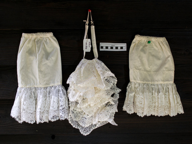
Ceremonial object - Clothing, 'Jabot' style collar and cuffs Moorabbin City Council Mayoral Robes, c1960
In clothing, a collar is the part of a shirt, dress, coat or blouse that fastens around or frames the neck and may be permanently attached to the main body of the garment (e.g. by stitching) or detachable. Today's shirt collars descend from the ruffle created by the drawstring at the neck of the medieval chemise, through the Elizabethan ruff and its successors, the whisk collar and falling band. Separate collars exist alongside attached collars since the mid-16th century, usually to allow starching and other fine finishing. Jabots made of lace and hanging loose from the neck were an essential component of upper class, male fashion in the baroque period. During the Edwardian period, and sporadically thereafter, ornamental collars were worn as a form of jewellery. Names for specific styles of collars vary with the vagaries of fashion. Jabots survive in the present days as components of various official costumes, as are those worn by judges and counsel throughout Australian courts and town mayors. 2018 Kingston City Council Mayor Steve Staikos asked CMHS to loan the Former Moorabbin Mayoral Robes and Jabot for display at KCC Office Cheltenham. These Moorabbin Mayoral Robe with Jabot are now displayed along with those of the former City of Chelsea Robe and the former City of Mordialloc Robe at Cheltenham . KCC possesses the original Mayoral Chains of each former Council and they are displayed on each Robe for the annual Opening Meeting of KCC in February. This set of a 'Jabot' style collar and cuffs was part of the ceremonial Mayoral Robes c1960- 94 for the City of Moorabbin 1934-94. This is the last City of Moorabbin Mayoral Robe and was worn by Mayor Ron Brownlees, (prior to amalgamation with the City of Glen Eira and City of Kingston in 1994), and donated to the City of Moorabbin Historical Society in February 2007 by the City of Kingston. The City of Moorabbin developed from the Moorabbin Roads Board of 1862, becoming The Shire of Moorabbin in 1871 and the City of Moorabbin in 1934. November 2018 At the request of the Mayor Cr Steve Staikos this Jabot Collar and Cuffs is now on display with the Mayoral Robes at Kingston City Council Offices Nepean Highway Cheltenham . A detachable , white, nylon, 'Jabot' style, standing collar with a pleated, ruffled, and lace-trimmed frill down the front and 2 matching cuffs that was part of the City of Moorabbin Mayoral Robes c1960 - 94 It has a tear in corner. clothing, collars, ornamental collars, civic robes, mayoral robes, moorabbin, cheltenham, bentleigh, lacework, dressmaking, fashion, formal wear, city of moorabbin. moorabbin shire, moorabbin roads board, brownlees ron, city of glen eira, city of ikngston -
 Warrnambool and District Historical Society Inc.
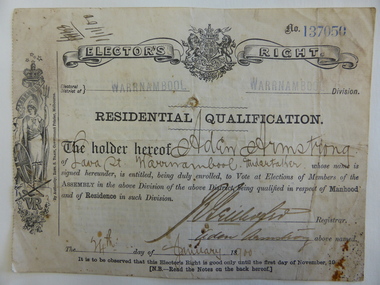
Original Document, Residential Qualification: Aden Armstrong, Circa 1900
This is an original Elector’s right certificate of 1900 for the Warrnambool Electoral District. This entitled the owner to vote at elections held for the Legislative Assembly in the Government of Victoria. The voter had to be male and resident in the electorate( in this case Warrnambool).This certificate was issued to Aden Armstrong an undertaker with a business in Timor Street opposite the Old National Bank which was at the corner of Kepler and Timor Streets. The Registrar who signed the certificate was Richard Geilhofer. The certificate was one of the items in the Henri Worland collection of historical society in 1973 by the Warrnambool City Council via Keith Arnel the Town Clerk. The timeframe of this document is on the cusp of major electoral change in Australia with the Federation of Australian states happening in 1901 and the granting of the vote for Australian women in the various states over the next decade.This item would have been a common item at the time as all those entitled to vote had to present same. It has local significance with Aden Armstrong being in business in Warrnambool for a number of years.Cream coloured paper with black text. Victorian coat of Arms at centre top of document. Drawing of lady holding shield on left side Handwritten information is written in faded black ink. Blue stamped number 137050 on top right corner. Back is printed with notes for the elector.Signature and date 1/11/00 at top left. Warrnambool is stamped in dark blue twice at top. Aden Armstrong of Lava St Warrnambool, Undertaker is written on the form with his signature at bottom right. Also signed by the registrar of the day, Richard Geilhofer. Date is also included 24th January 1900 elector's right certificate, aden armstrong, warrnambool, warrnambool undertakers -
 Kew Historical Society Inc
Plan, Melbourne and Metropolitan Board of Works, Borough of Kew : Detail Plan No.1562, 1905
The Melbourne and Metropolitan Board of Works (MMBW) plans were produced from the 1890s to the 1950s. They were crucial to the design and development of Melbourne's sewerage and drainage system. The plans, at a scale of 40 feet to 1 inch (1:480), provide a detailed historical record of Melbourne streetscapes and environmental features. Each plan covers one or two street blocks (roughly six streets), showing details of buildings, including garden layouts and ownership boundaries, and features such as laneways, drains, bridges, parks, municipal boundaries and other prominent landmarks as they existed at the time each plan was produced. (Source: State Library of Victoria). This plan forms part of a large group of MMBW plans and maps that was donated to the Society by the Mr Poulter, City Engineer of the City of Kew in 1989. Within this collection, thirty-five hand-coloured plans, backed with linen, are of statewide significance as they include annotations that provide details of construction materials used in buildings in the first decade of the 20th century as well as additional information about land ownership and usage. The copies in the Public Record Office Victoria and the State Library of Victoria are monochrome versions which do not denote building materials so that the maps in this collection are invaluable and unique tools for researchers and heritage consultants. A number of the plans are not held in the collection of the State Library of Victoria so they have the additional attribute of rarity.Original survey plan, issued by the MMBW to a contractor with responsibility for constructing sewers in the area identified on the plan within the Borough of Kew. The plan was at some stage hand-coloured, possibly by the contractor, but more likely by officers working in the Engineering Department of the Borough and later Town, then City of Kew. The hand-coloured sections of buildings on the plan were used to denote masonry or brick constructions (pink), weatherboard constructions (yellow), and public buildings (grey). MMBW detail plan No.1562, in contrast to No.1561 includes the names of a large number of houses: in Barkers Road: ‘Ashwick’, ‘Owasso’, ‘Anadiha’, ‘Eurobin’, ‘Carlsruhe’, ‘Arlington’ and ‘Altyre’. Unnamed but clearly represented on the plan is what was then known as the ‘Auburn Heights Recreation Club’, which at this stage included a Bowling Green, a Croquet Green and two Tennis Courts. On the plan, Brougham Place, as it was then known, is represented. It was later renamed Daniell Place. The aforementioned Arlington is now the junior campus of Preshil. melbourne and metropolitan board of works, detail plans, mmbw 1562, cartography -
 Ballarat Tramway Museum
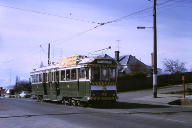
Magazine, Association of Railway Enthusiasts (ARE), "Australian Railway Enthusiast - Vol 9, No. 4, December 1971", Dec. 1971
Copy of the Australian Railway Enthusiast - Vol 9, No. 4, December 1971, which contains seven photographs of the closure of the Ballarat Tramway System on 19/9/1971 by Greg Triplett. Item 579 refers for centre page photograph. Magazine has articles on the Beech Forest Narrow Gauge, The Atjeh Tram (Indonesia), cable cars preserved in Melbourne and a derailment at Yering Vic. in 1900. Ballarat Photos 1 - 40 in Lydiard St. 2 - Bogie car in Wendouree Parade from the wheat silos 3 - Intersection of Sturt and Lydiard Street from the Town Hall 4 - Tram at City Centre with Boer War (?) statue in front of the tram - night photo 5 - 35 at Sebastopol Terminus - night photo 6 - 42 at the Lydiard Street terminus - night photo 7 - 40 leaving Sebastopol as the last tram - night photo (see item 579) Second copy added 31-8-2017. Second copy has a "Technical Book & Mag. Co." yellow label on the front cover.trams, tramways, ballarat, closure, lydiard st, sturt st, sebastopol -
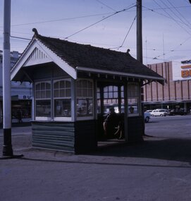 Ballarat Tramway Museum
Slide - 27 mm sq slide/s - set of 4 - shelters, Lilian Butler, August or September 1971
Yields information about some of the individual street tramways shelters at tram stops and their appearance.Set of four Colour 27 x 27 mm slide in a Kodachrome cardboard mount. .1 - Grenville St with two ladies sitting inside, has the Big W store in the background. .2 - Concrete shelter with curved roof - Wendouree Parade near - has the photographer's purse and umbrella on the seat. This shelter was located at Forest St. From discussions with Dave Macartney and Alastair Reither 11/9/2016, it was there in the 1990 hail storms as they sheltered under it, but disappeared soon after - the construction of the roundabout would have absorbed its location. .3 - timber based shelter with flat roof - Wendouree Parade near Dowling St. This shelter remains in position in 9/2016. See Reg Item 6551 for a digital image. .4 - Shelter at Tramway Centre, City, Sturt St and Lydiard Sts, looking towards the Town Hall Slide mount date August or September 1971. Photo from the collection of Lilian Butler.ballarat, tramways, trams, shelters, grenville st, wendouree parade, sturt st, lydiard st, city, tramway centre, forest st, dowling st -
 Bendigo Historical Society Inc.
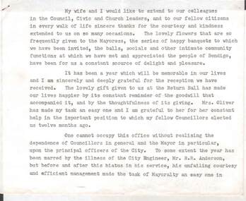
Document - NORMAN OLIVER COLLECTION: MAYORAL RETIREMENT SPEECH, UNDATED
The Norman Oliver collection. Norman Oliver was three times Mayor of Bendigo - 1950-51, 1964-65, 1970-71. Six typed pages, stapled, undated. Mentions that his successor as Mayor will be Cr Turner. R. F. (Dick) Turner was Mayor 1965-66. Individuals mentioned in this speech : Mr R. R. Anderson (City Engineer), Mr H. A. Moors (Bendigo Sewerage Authority), Mr A. J. Watts (Town Clerk) and wife, Miss B. Liddell (staff), Douglas Anderson (Victorian Promotion Committee), Mr Sidney Morrell (New York), Mr Brian Harrison (MP of London), Sir Norman Martin (Victorian Inland Meat Authority), Mr Evans (Department of Immigration), Lindsay Thompson (MLC and Minister of Housing). Mr Sid Mellis and Mr J. Jeffrey, both retired Hargreaves St businessmen, have been associated with the Mayor's Blanket Appeal.bendigo, council, speech notes, norman joseph oliver , councillor norman oliver. mayor of bendigo. victorian promotion committee. victorian inland meat authority. mayor's blanket appeal. -
 Federation University Historical Collection
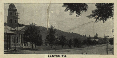
Photograph (black & White), Ladysmith - South Africa
Ladysmith is a city in the Uthukela District of KwaZulu-Natal, South Africa. In 1847 after buying the land from the Zulu King Mpande, a number of Boers settled in the area and called it the Republic of Klip River. The Republic was annexed by the British in the same year and on 20 June 1850 it was proclaimed a township called Windsor. In October 1850 the name changed to Ladysmith after Juana Maria de los Delores de Leon Smith, also known was "Lady Smith", the Spanish wife of Sir Harry Smith, the Governor of the Cape Colony. He was also High Commissioner in South Africa from 1847 to 1852. A for was built in 1860 to protect the villagers from the Zulu. During the Second Boer War British commander Lieutenant General Sir George White made Ladysmith his centre of operations for the protection of Natal against the Boer forces. A number of short lived battles were fought for the control of the town. After suffering many casualties the British retreated to Ladysmith. While the British regrouped in the town, Boer forces surrounded Ladysmith. The siege lasted 118 days during one of the most crucial stage of the war. Three attempts by General Sir Redvers Buller to break the siege resulted in defeat for the British forces at the Battles of Colenso, Spion Kop and Vaal Krantz. The Boer forces attempted to break the siege. This led to the Battle of Platrand, or Wagon Hill, south the town. Buller finally broke the siege in February 1900 after defeating the Boers. Sir Winston Churchill, a young war correspondent was present at the Relief of Ladysmith after having been taken prisoner - between Ladysmith and Colenso - and escaping earlier during the war.Individual image from photographed poster of tobacco and cigarette cards.ladysmith, south africa, zulu, boers, republic of klip river, windsor, lady smith, sir harry smith, governor, cape colony, high commissioner, sir george white, natal, siege of ladysmith, sir redvers buller, battle of colenso, battle of platrand, sir winston churchill, wagon hill -
 Ballarat Tramway Museum
Photograph - Digital image Set of 10, Tony Smith, 1971
Yields information about Ballarat Tramways and trams prior to the closure of the tramway system.Set of 10 digital images of Ballarat trams prior to closure, scanned from original slides by Tony Smith, 1971 prior to closure of the system. .1 - 42 in Barkly St - at top of hill, outbound to Mt Pleasant. Note the fire alarm on the right hand side of the photo. .2 - 42 and 21 crossing at Grant St Loop, Barkly St, Mt Pleasant. 42 outbound, 21 inbound. .3 - 34 and 21 crossing at Parker St Loop, with Ballarat College in the background. 42 in bound to City and Mt Pleasant, 21 showing Sturt St. West. .4 - 21, Wendouree Parade at the south end of the old parking loop. .5 - 42 and 21 crossing at Gardens Loop. 42 showing Mt Pleasant, 21 Gardens via Sturt St West. .6 - ditto .7 - 41 showing Special at intersection of Ripon St and Sturt St with a single trucker tram ex View Point waiting to turn into Sturt St. 41 has two Johnnie Walker Whiskey roof advertisements. .8 - Two single truckers - not well focused - 21? and 13? crossing at Mill St loop, has the hospital in the background. Conductor leaning out of the door on the outbound tram. .9 - 42, bogie tram and a single trucker at the City terminus (Sturt and Lydiard Sts). Has a group of SEC trammies standing alongside the tram. Has Racey's store and the SEC offices in the background. 42 has a briquettes roof advert. .10 - 34 in Sturt St, at the City terminus, with passengers getting onto the tram. Has the Town Hall, Myers store, Gemmola's Pharmacy in the background. Tram has the destination of Gardens via Drummond St. Nth. Has two trammies (crews) standing alongside the tram stop sign.trams, tramways, sturt st west, barkly st, grant st, parker st loop, sturt st, view point, ripon st, mill st loop, crews, town hall, tram 42, tram 21, tram 34, tram 41, tram 42 -
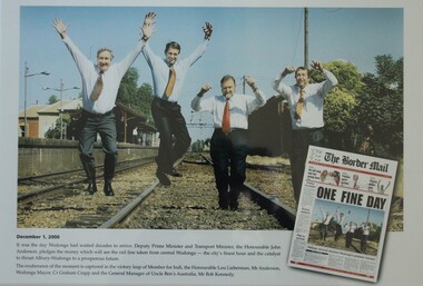 Wodonga & District Historical Society Inc
Photograph - One Fine Day - decision to move Wodonga Railway Line, 2000
On December 1, 2000 it was finally announced that the railway line would be moved away from the centre of the Wodonga CBD after many years of lobbying. Since its opening in 1873 the railway line had crossed High Street, originally called Sydney Road. The railway had bisected the city with level crossing gates frequently stopping the flow of traffic as trains passed through. The Wodonga Rail Bypass project moved Wodonga station from the original central location to a position on a new line on the northern edge of the town. Not only did this release land in the middle of the city for commercial and public use, but also eliminated 10 level crossings. The project actually commenced in 2008 with the last passenger train passing through Wodonga on 8 November 2008. On 23 July 2010, the new rail bypass was opened, and the original line through Wodonga closed. In this image the decision is celebrated by the Member for Indi, the Honourable Lou Lieberman, Deputy Prime Minister and Transport Minister John Anderson, Wodonga Mayor Cr. Graham Crapp and General Manager of Uncle Ben's Australia, Mr Bob Kennedy.This image commemorates a significant occasion in the development of the Central Business District of Wodonga, Victoria.A framed photo of four men celebrating the decision to move the railway out of the centre of Wodonga as well as an image of the from page of the Border Mail newspaper.wodonga railway, wodonga rail bypass, city of wodonga -
 City of Moorabbin Historical Society (Operating the Box Cottage Museum)
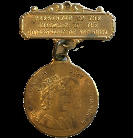
Badge - Royal Visit 1954
his medal was issued for schools to commemorate the Queen visit. The Queen visited Victoria from 24 February to 9 March 1954. In 1954 Queen Elizabeth II became the first reigning monarch to tour Australia. She arrived in Sydney with her husband the Duke of Edinburgh on 3 February 1954 and departed the country from Fremantle on 1 April. The visit was tremendously popular. The attractive young Queen was the first royal to tour Australia in twenty years. She graciously endured a gruelling schedule of 33 flights, covering 10,000 miles by air, and 207 car trips, covering 2,000 miles by road and taking 130 hours. She visited approximately 70 country towns, all capital cities except Darwin, and made about 100 speeches.Medal BadgeEIIR Royal Visit 1954 Victoriaroyal visit 1954, badge, victoria, children -
 Kiewa Valley Historical Society
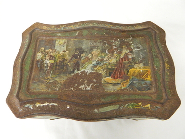
Tin Biscuit/Tea, Early to mid 1900s
This biscuit/tea caddy was probably targeting the "theatre going" family or those who liked looking at the colourful shakespearian scenes. This item however demonstrates that the rural (Kiewa Valley) appreciation of classic English plays was, in this time period (early 1900's), just as strong as in the larger towns and cities. This item also presents the period in which the "olde" Elizabethian phrases and words were taught in regional high schools. Although this speech pattern and phraseology was of a specific time period and going out of fashion when Australia was first settled it was an inherited form of communication(higher social/economical level). In the context of the rural Australia "scene" and in this time frame of the elite "boarding school" generation this item was a visual reinforcement of the education level and position of the family who owned this tin.This item is highly significant because it not only presents the social aspects of early life in the Kiewa Valley but also the variety of educational levels and economical variations of the rural population within the Kiewa Valley. The egalitarian perception of the inhabitants of the Kiewa Valley was still at the infancy of early Australian social interactions. This biscuit /tea container was however a leveling of the socio-economic playing field of the time.This biscuit or tea tin, has besides having an outer lid (hinged), it also has an internal lid(with a circular finger grip). Although the shape is rectangular it has a slight concave bulge at each side of the centre of each of its main frame. It is made of pressed light steel and has a raised floor. The corners are bevelled and the outer lid has a bevelled slope ridge in parallel to the extremities of the main tin frame. There are painted scenes from the following Shakespearian plays on each side of the tin; "As you like it", "Hamlet" and on each of the bevelled corners are the portraits of Shakespeare(in the middle), the caricature mask faces of "the theatre" above and on the bottom section the "Director's chair"food storage, kitchen table container, domestic educational storage, shakespeare illustrations -
 Wodonga & District Historical Society Inc
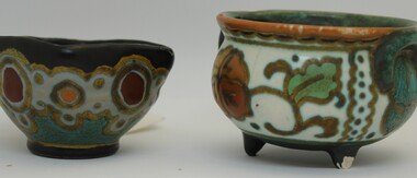
Domestic object - Bowl and cup set, Plateelbakkerij Zuid-Holland, c1923
The mark on these items indicate that they are Gouda pottery. Gouda is a style of Dutch pottery named after the city of Gouda, where it was historically manufactured. Gouda pottery gained worldwide prominence in the early 20th century and remains highly desirable to collectors today. Gouda pottery is diverse and visually distinctive in appearance, typically illustrated with colourful and highly decorated Art Nouveau or Art Deco designs. Pieces were mass produced but painted by hand by many individual artists. The dating mark system used and the small house represent the pottery of Plateelbakkerij Zuid Holland (PZH). This is a simplification of the "Lazarus-poort" (the Lazarus Gate). It stands for a building in the town of Gouda that dates back to 1609 where they assisted people who suffered from leprosy. The PZH produced pottery from as early as 1898 until 1965.This item is from Raper Collection donated to the Wodonga Historical Society by Mrs. Jean Raper. Hand painted pottery cup and bowl in art deco designs. These items are examples of Gouda pottery.Underneath cup : "LQ4/HENLY/A.R.J.T/HOLLAND" with 2 Vertical diamonds representing 1923 and house which is stylised image of the Gate of Lazurus. Underneath Bowl: "401/PEGGY/2 Vertical Diamonds 3 W v V/HOLLAND"domestic items, gouda pottery, ceramics -
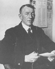 Mentone Grammar School
J Allan Anderson - one of the founders of Mentone Grammar School
J Allan Anderson graduated from the University of Melbourne in 1902. The following year he joined a law practice in the Victorian country centre of Stawell, where he met and married Ethel M. Allingham. Moving to East Kew, Melbourne, in 1917, where his son attended Trinity Grammar School. By March 1921 the family had exchanged their annual summer holidays at Mentone for permanent residence when they moved into Captain Dawson's former home, 'Riviera' off Mentone Parade. Disappointed with standards at this son's new local school and now living in a fast-growing town and district, in 1922, on a train journey to his office in the City, 46-year-old solicitor J.A. Anderson came up with the idea to form a new grammar school for boys in Mentone. -
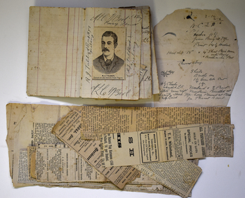 Warrnambool and District Historical Society Inc.
Memorabilia - Newspaper cuttings scrapbook, Martin Carter, Saddler, Warrnambool, late 19th century (1887-1894)
This scrapbook contains newspaper cuttings, mainly about football, and other written material from the late 19th century. It belonged to Martin Carter ((1870-1943), a Warrnambool saddler who worked for many years in the saddlery business established by his father, Samuel. Martin Carter was very active in community affairs - President of the Warrnambool Bowling Club, a member of the local Volunteer Militia, Secretary of the Progress Association, a football player and umpire and a local cricketer. He was the Secretary of the Warrnambool Town (later City) Band for fifty years and a memorial plaque in his honour was erected at the Band headquarters in Warrnambool. He was also a Warrnambool Councillor (1917-1925) and Warrnambool Mayor (1922-24). His interest in football can be seen from the great number of football newspaper cuttings in this notebook.This little notebook is most interesting as it provides us with details on football in the Warrnambool district in the late 19th century and gives us an indication of the popularity of the game at that time. It is a valuable research tool.This is a small notebook with a black cover. The pages contain ruled red lines over which have been pasted newspaper cuttings. Some pages have handwritten material and some pages are blank. There are also several loose cuttings. The notebook has been stapled but the staples have been removed.M.L.Carter Warrnambool June 13th 1887 S.Carter Saddler Warrnambool (stamp)warrnambool town band, martin carter warrnambool, football in the warrnambool district, sydney giddings warrnambool saddler -
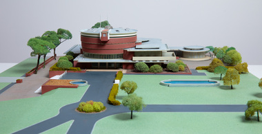 Bayside Gallery - Bayside City Council Art & Heritage Collection
Model, Alan W. Chandler, Brighton Municipal Complex, 1959
This model of the Brighton Municipal Offices was made by Alan W. Chandler. The Brighton Municipal Offices were designed by Kevin Knight of Oakley and Parkes with the engineers John Connell and Associates and were erected by Prentice Builders Pty Ltd. The foundation stone was laid on 13 February 1959 and the building was opened on 21 July 1961. The interior decoration and furniture was by Grant Featherston. As is common practice, an architectural model was prepared to present the final concept of the building for approval to the Brighton City Council. In February 1959 festivities occurred to celebrate the centenary of the municipality of Brighton. A garden party attended by two hundred Brighton residents was held in the grounds of the Brighton Town Hall. This model graced the centre of the lily pond during the event. The following day the foundation stone of the Brighton Municipal Offices was laid.Architectural model of a large public building in orange brick, the main cylindrical tower is set within a rectangular structure, with circular and oval roof structures. The model is set within landscaped grounds with paths, a water feature, several trees and bushes, lawns and flower beds.brighton municipal complex, brighton civic centre, brighton chambers, architectural model, model, alan w. chandler, kevin knight, oakley and parkes, architecture, municipal offices, municipal building, scale model -
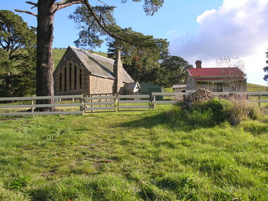 Ballarat Heritage Services
Photograph - Photograph - Colour, Clare Gervasoni, Former School at Weatherboard, Victoria, c2010
Weatherboard is a small town in Western Victoria.Anecdotally the name is thought to have originated because it was the first place in the region to have a home built using weatherboard rather than corrugated iron, stone or bricks. It is in the boundaries of the City of Ballarat. The School, Number 656, was opened on 01 August 1862 and closed on 04 February 1948. it was also known as Weatherboard Hill Common School and Weatherboard Hill State School.The bluestone school building had a slate roofand its first head teacher was James Richmond..In 1915 Health Officer, Dr Willis, strongly condemned the old bluestone building as being damp and unsanitary. in 1948 enrolments dropped to 6 and the school closed. The Weatherboard State School World War One Honour Board is located at Burrumbeet Hall. An early bluestone school known as the Weatherboard School.weatherboard school, former weatherboard school, education, weatherboard hill common school, weatherboard hill state school -
 Eltham District Historical Society Inc
Document - Property Binder, Eltham Town Square, Commercial Place, Eltham
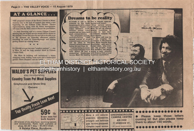
1. Dreams to be reality, The Valley Voice, 15 August 1979, p2 - announcement of proposed town square of 1800 square metres of shop area and open courtyard to be sited in the carpark between Arthur Street and Pryor street. The plans also included tree-lined walkways from both Arthur Street and a pededstrian footbridge across Main Road leading to aregular open-air market and tavern. Shop owners facing Main Road were to be encouraged to turn their businesses towards the square. On reverse side - 'General' Marshall and his troops; Valley votes in five new faces, The Valley Voice, 15 August 1979, p1 - picture showing newly elected Cr Robert Marshall 2. Square plan on display, Diamond Valley News, Tuesday, June 23, 1981, p1 - Council's prefered proposal on display to the public. On same page a story about the son of Cr Bob Manuell being attacked on the train from the city. On reverse side - Helping people - here and abroad by Marguerite Marshall, Diamond Valley News, Tuesday, June 23, 1981, p2 - about Keith Ryall of Zig Zag Road, the Apex international councillor for Australia 3. Plan: Eltham Town Centre property Acquisition, Shire of Eltham March 1994businesses, arthur street, bible street, commercial place, dudley street, eltham, franklins supermarket, luck street, main road, map, mcewans, pryor street, safeway supermarket, apex club, bronwyn ryall, keith ryall, zig zag road, cr bob manuell, cr robert allen, det sgt noel murphy, eltham chamber of commerce, eltham police, eltham shire council, eltham town square, lorraine manuell, pauline toner mp, robert manuell, rodney roscholler, shire planner, vicrail, elections, h&j white general store, hurstbridge, leslie bowker, main street, mrs marshall, pam lawson, robert marshall, rosemary tovey, central park, comfort station, eltham little theatre, montmorency, public toilets, rotex cinema, were street -
 Glenelg Shire Council Cultural Collection
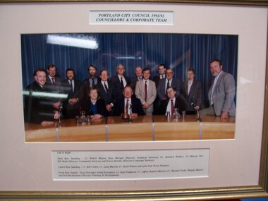
Photograph - Photograph - Portland City Council, 1991/92. Councillors and Corporate Team, 1992
Glenelg Shire Council RecordsColour photograph of 13 men and 2 women standing or seated behind a long curved table, in front of blue curtains.Front: Portland City Council, 1991/92 / Councillors and Corporate Team (top centre, typed). Left to Right: Back Row Standing - Cr. Robert Menzel, Ross Morgan (Director Technical Services), Cr. Bernard Wallace, Cr. Murray Box, Bill Hebb (Director Community Services) and Trevor Hornby (Director Corporate Services). Centre Row Standing: Cr. Bill Collett, Cr. Lynn Murrell, Cr. Keith Wilson and Lelia Pop (Town Planner). Front Row Seated - Greg Trevaskis (Chief Executive), Cr. Kay Frankcom, Cr. Jeffrey Baulch (Mayor), Cr. Michael Noske (Deputy Mayor) and Neil Buckingham (Director Planning & Development). -
 Ballarat Tramway Museum
Photograph - Digital image Set of 10, Tony Smith, 1971
Yields information about Ballarat Tramways and trams prior to the closure of the tramway system.Set of 10 digital images of Ballarat trams prior to closure, scanned from original slides by Tony Smith, 1971 prior to closure of the system. The following photos have suffered colour change and showing some deterioration - fungal growth. .1 - 35 (Sebastopol), with the Town Hall and Gemmola's chemist in the background. Tram waiting at the tram stop. .2 - 27 at Victoria St loop, showing Gardens via Drummond St Nth. .3 - 35 at Armstrong St inbound showing Lydiard St Nth. Has the Commonwealth bank in the background. .4 - 32 westbound in Sturt St between Dawson and Lyon Streets, tram has the destination of Gardens via Drummond Nth. Has the Town Hall and other buildings in the background. .5 - 17 inbound at Dawson St. Tram has destination of Mt Pleasant. .6 - 39 picking up passengers at the tram stop on the west side of Dawson St. Has the Ritzy cafe and the Golden City hotel in the background. Tram appears to be well loaded with lady passengers and has a "Everything under my control in my all electric kitchen" SEC roof ad. .7 - 37 using the Dawson St crossover - has St Patricks Cathedral in the background. .8 - 21 entering the depot with Lake Wendouree in the background. .9 - 11 sitting in 0 road at the depot. .10 - 41 at the depot on 2 road. Tram has two Johnny Walker Whiskey roof adverts.trams, tramways, sturt st, victoria st, dawson st, lake wendouree, wendouree parade, depot, tram 35, tram 27, tram 32, tram 17, tram 39, tram 37, tram 21, tram 11, tram 41 -
 Numurkah & District Historical Society
Functional object - Numurkah Shire Common Seal
THE CONSTITUTION OF MUNICIPALITIES GENERALLY. DIVISION 1. INCORPORATION AND GOVERNMENT OF MUNICIPALITIES AND BOUNDARIES OF DISTRICTS. 8. (1) The inhabitants of every shire borough town and city inhabitants of for the time being subject to the provisions of this Act shall, under corporation. the name of the president councillors and ratepayers of such shire N°-5203 «• '• the mayor councillors and burgesses of such borough the mayor councillors and burgesses of such town or the mayor councillors and citizens of such city as the case may be, be a body corporate with perpetual succession and a common seal with power to break alter and change the same from time to time with the approval of the Governor in Council and shall by such name be capable in law of suing and being sued, of purchasing holding and alienating land, and of doing and suffering subject to the provisions of this Act all such other acts and things as bodies corporate may by law do and suffer. (2) The corporation of ******** Shire Common Seal 54. The common seal of the municipality shall be kept in a box having two locks, of one of which locks the chairman of the municipality shall have a key and of the other of which locks the key shall be kept by the municipal clerk; and the corporate seal shall not be affixed to any document unless the chairman of the municipality and one other member of the council or in the absence of such chairman unless two councillors be present. 91. The Council’s Common Seal (1) The Chief Executive Officer must ensure the security of the Council's common seal at all times. (2) The Council's common seal may only be used on the authority of the Council given either generally or specifically and every document to which the seal is affixed must be signed by the Chief Executive Officer or a senior officer authorised by him or her. (3) Any person who uses the Council's common seal without authority is guilty of an offence. (4) Any person who uses any replica of the council’s seal without authority is guilty of an offence. The Numurkah Shire was amalgamated into the Moira Shire and the seal now redundant. This is the only Numurkah Shire Common Seal in existence.local government, common seal, numurkah -
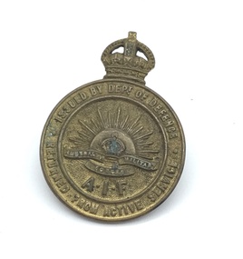 Melbourne Legacy
Badge, Badges from World War One
A variety of badges that once belonged to J B McLean some are souvenirs and a couple are from the A.I.F. The badges for those returned from active service could be worn by soldiers and nurses who returned to Australia from active service and were honourably discharged. From information found online: The badge from Ypres is known as a sweetheart badge. Often produced post war as a souvenir. It is the arms of the city of Ypres/Ieper. The crown over the shield is called a "mural crown" and is often seen as part of the arms of cities and towns. The phrase 'sweetheart brooch' is commonly used, but is misleading, as it was not only 'sweethearts' that wore them. These were with other World War 1 memorabilia that has come from Private John Basil McLean, 2nd Reinforcements, 37th Battalion, A.I.F. J.B. McLean (Service No. 13824) was from near Maffra, Victoria and enlisted on 22 January 1916. He embarked on 16 December 1916 for Europe. He spent time with the Australian Field Artillery (Pack Section). At the end of the war he worked for a year at the A.I.F. Headquarters in London before returning to Australia on the 'Ceramic', arriving in Portsea in 1920. His full war record is available from the National Archives of Australia (B2455, MCLEAN JBM).This is an example of badges held by an ex soldier.Seven assorted badges collected by J B McLean. Two returned from active service AIF badges. A kangaroo badge on a blue enamel circle with the word ANZAC. Badge with the arms of Ypres surmounted by a crown. A pin with a field canon and a motto in latin. A pin with the Australian coat of arms from HMAS Australia sailing in the Great Fleet in 1916. A medallion with the Australian naval flag and the Union Jack.01122.1 On the front 'Issued by Dept of Defence. Returned from Active Service. Australian Military Forces. A.I.F.'. On the reverse '188589 Stokes and Sons Melb' 01122.2 'ANZAC' written in silver, on the reverse 'AJC Sterling' 01122.3 'Ypres' 01122.4 A latin phrase: 'Ubique constru stabiles Australia'. It could translate as 'everywhere together and trust'. 01122.5 On the front 'Grand Fleet. H.M.A.S. Australia 1916' 01122.6 On the front 'Issued by Dept of Defence. Returned from Active Service. Australian Military Forces. A.I.F.' On the reverse '117083 ? Perth' 01122.7 on the reverse 'Imitation'.world war one, soldier -
 Kew Historical Society Inc
Plan, Melbourne & Metropolitan Board of Works : Borough of Kew : Detail Plan No.1578, 1904
The Melbourne and Metropolitan Board of Works (MMBW) plans were produced from the 1890s to the 1950s. They were crucial to the design and development of Melbourne's sewerage and drainage system. The plans, at a scale of 40 feet to 1 inch (1:480), provide a detailed historical record of Melbourne streetscapes and environmental features. Each plan covers one or two street blocks (roughly six streets), showing details of buildings, including garden layouts and ownership boundaries, and features such as laneways, drains, bridges, parks, municipal boundaries and other prominent landmarks as they existed at the time each plan was produced. (Source: State Library of Victoria). This plan forms part of a large group of MMBW plans and maps that was donated to the Society by the Mr Poulter, City Engineer of the City of Kew in 1989. Within this collection, thirty-five hand-coloured plans, backed with linen, are of statewide significance as they include annotations that provide details of construction materials used in buildings in the first decade of the 20th century as well as additional information about land ownership and usage. The copies in the Public Record Office Victoria and the State Library of Victoria are monochrome versions which do not denote building materials so that the maps in this collection are invaluable and unique tools for researchers and heritage consultants. A number of the plans are not held in the collection of the State Library of Victoria so they have the additional attribute of rarity.Original survey plan, issued by the MMBW to a contractor with responsibility for constructing sewers in the area identified on the plan within the Borough of Kew. The plan was at some stage hand-coloured, possibly by the contractor, but more likely by officers working in the Engineering Department of the Borough and later Town, then City of Kew. The hand-coloured sections of buildings on the plan were used to denote masonry or brick constructions (pink), weatherboard constructions (yellow), and public buildings (grey). MMBW Plan No.1578 is significant in that it defines the extent of two private schools: Xavier College and Kew High School (now part of Trinity Grammar) by 1904. In relation to the latter, the plan clarifies which buildings the High School operated from behind the mansion ‘Molina’. Established in 1902, Trinity Grammar was to later lease and subsequently buy Molina (now ‘Merritt House’) and ‘Elsinore’ (now ‘Roberts House’). Xavier College had been established in 1872. This 1904 plan delineates the West Wing and the Great Hall (built in 1890).melbourne and metropolitan board of works, detail plans, maps - borough of kew, mmbw 1578, cartography -
 Kew Historical Society Inc
Plan, Melbourne & Metropolitan Board of Works : Borough of Kew : Detail Plan No.1590, 1905
The Melbourne and Metropolitan Board of Works (MMBW) plans were produced from the 1890s to the 1950s. They were crucial to the design and development of Melbourne's sewerage and drainage system. The plans, at a scale of 40 feet to 1 inch (1:480), provide a detailed historical record of Melbourne streetscapes and environmental features. Each plan covers one or two street blocks (roughly six streets), showing details of buildings, including garden layouts and ownership boundaries, and features such as laneways, drains, bridges, parks, municipal boundaries and other prominent landmarks as they existed at the time each plan was produced. (Source: State Library of Victoria)This plan forms part of a large group of MMBW plans and maps that was donated to the Society by the Mr Poulter, City Engineer of the City of Kew in 1989. Within this collection, thirty-five hand-coloured plans, backed with linen, are of statewide significance as they include annotations that provide details of construction materials used in buildings in the first decade of the 20th century as well as additional information about land ownership and usage. The copies in the Public Record Office Victoria and the State Library of Victoria are monochrome versions which do not denote building materials so that the maps in this collection are invaluable and unique tools for researchers and heritage consultants. A number of the plans are not held in the collection of the State Library of Victoria so they have the additional attribute of rarity.Original survey plan, issued by the MMBW to a contractor with responsibility for constructing sewers in the area identified on the plan within the Borough of Kew. The plan was at some stage hand-coloured, possibly by the contractor, but more likely by officers working in the Engineering Department of the Borough and later Town, then City of Kew. The hand-coloured sections of buildings on the plan were used to denote masonry or brick constructions (pink), weatherboard constructions (yellow), and public buildings (grey). Surveyed by the Board of Works in 1903 and published in 1904, Plan No.1590 shows development north of Cotham Road. While this plan includes built structures in Mary Street, Cotham Road, High Street, Park Hill Road, Kent Street, Ridgeway Avenue, and Ermington Lane (now Ermington Place), only part of this section was notated and coloured in this contractor’s copy. Numerous houses, large and small are named on the plan: ‘Cholula’, ‘Belper’, ‘The Uplands’, ‘Spring Grove’ facing Cotham Road; ‘Marion’ facing Kent Street; and ‘Kia Ora’ facing Ridgeway Avenue.melbourne and metropolitan board of works, detail plans, mmbw 1590, survey plans - borough of kew, cartography -
 Kew Historical Society Inc
Plan, Studley Park Estate, 1910
Prue Sanderson, in her groundbreaking ‘City of Kew Urban Conservation Study : Volume 2 - Development History’ (1988), summarised the periods of urban development and subdivisions of land in Kew. The periods that she identified included 1845-1880, 1880-1893, 1893-1921, 1921-1933, 1933-1943, and Post-War Development. These periods were selected as they represented periods of rapid growth or decline in urban development. An obvious starting point for Sanderson’s groupings involved population growth and the associated economic cycles. These cycles also highlighted urban expansion onto land that was predominantly rural, although in other cases it represented the decline and breakup of large estates. A number of the plans in the Kew Historical Society’s collection can also be found in other collections, such as those of the State Library of Victoria and the Boroondara Library Service. A number are however unique to the collection.The Kew Historical Society collection includes almost 100 subdivision plans pertaining to suburbs of the City of Melbourne. Most of these are of Kew, Kew East or Studley Park, although a smaller number are plans of Camberwell, Deepdene, Balwyn and Hawthorn. It is believed that the majority of the plans were gifted to the Society by persons connected with the real estate firm - J. R. Mathers and McMillan, 136 Cotham Road, Kew. The Plans in the collection are rarely in pristine form, being working plans on which the agent would write notes and record lots sold and the prices of these. The subdivision plans are historically significant examples of the growth of urban Melbourne from the beginning of the 20th Century up until the 1980s. A number of the plans are double-sided and often include a photograph on the reverse. A number of the latter are by noted photographers such as J.E. Barnes.Coloured lithograph of a subdivision plan of the Studley Park Estate, bordered by Yarra, Willsmere Road and the Outer Circle Railway line. The estate was listed in 1910 and was the subject of a planning dispute between the developer and the Town of Kew in relation to flood levels and the suitability of the land for housing. In many cases the names of streets were subsequently changed. The layout was also affected by the creation of the Eastern Freeway. A newspaper report of the day described the subdivision as a: "GOLDEN OPPORTUNITY. We are pleased to submit for PRIVATE SALE that magnificent ESTATE, situated only 4 1/2 miles from the Melbourne General Post Office, STUDLEY PARK ESTATE. KF/NV. Doubtless the CHEAPEST LAND EVER OFFERED having extensive frontages to the prettiest spot on the River Yarra and the National Park, commanding lovely river and landscape views, and acknowledged to be the finest land available so close to the city. The PRICES ARE EXTREMELY MODERATE; The TERMS ARE SIMPLY MARVELLOUS. NO DEPOSIT. NO DEPOSIT. NO DEPOSIT. Allotments and prices to suit everyone."subdivision plans - kew, studley park estate