Showing 1916 items matching " facilities"
-
 Kew Historical Society Inc
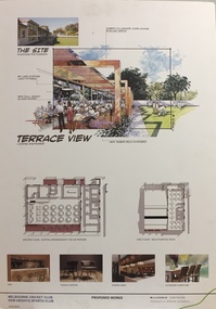
Plan - Architectural Sketch, MCC Kew Sports Club Proposed Works Terrace View, 2012
Sports Clubs in Kew in the final decades of the 19th century and in the early 20th century were often umbrella organisations with facilities for a number of sports. Typically in Kew, this included teams in lawn bowls, tennis and croquet. The Kew Bowling Club was formed in 1880 while the privately owned Auburn Heights Recreation Club was opened in 1904. By 1998, the two Clubs decided to amalgamate at the Auburn Heights site in Barkers Road, forming the Kew Heights Sports Club. The combined club was itself taken over by the Melbourne Cricket Club in 2012 becoming MCC Kew Sports Club. In 2017 MCC Kew closed and its landholding was subsequently sold to Carey Baptist Grammar School. Both the Kew and Auburn Heights Clubs assembled important collections. These historically significant and large collections were donated to the Society in 2020. The collections include manuscripts, pictures, trophies, plans, honour boards etc. The combined collections of the four sporting clubs making up the collection number hundreds of items that are historically significant locally. They are also significant to the sporting history of the greater Melbourne area and to the sports of lawn bowls and tennis in Australia in the 19th and 20th centuries. The collection illuminates two of the Victorian historic themes - 'Building community life' through forming community organisations and 'Shaping cultural and creative life' by participating in sport and recreation.Architectural sketches on corflute of proposed designs for the new MCC Kew Sports Club by McIldowie Partners (Architects & Interior Designers), 2012.mcc kew sports club - barkers road - kew (vic), mcildowie partners -- architects, architectural sketches -
 Bendigo Military Museum
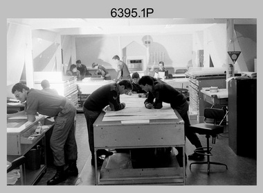
Photograph - Army Survey Regiment – Map Production, Fortuna, Bendigo, 1986
These 17 photographs of the Army Survey Regiment’s map production and facilities were taken at Fortuna Villa, Bendigo, April 1986. Photos .1P to .3P were taken in Cartographic Squadron’s Correcting Section in the Attic. located on the top floor of Fortuna Photos .4P to .5P were taken in Cartographic Squadron’s Proving Section, located in the Ballroom also on the top floor facing the lake. The technicians were probably involved in a rapid response map production, as they all were wearing field uniforms. As ‘Regiment Overcrowding’ is annotated on the plastic sleeve holding the negatives, it seems the photos were taken when the unit was at its capacity to demonstrate the lack of suitable work areas. The Army Survey Regiment’s Duty Room, RAP and Carpark appearing in Photo .10P was probably taken from the top steps near the SGT’s accommodation block. Two of the photos in this set are also published in item 6096.5P.This is a set of 17 photograph of Map Production and car park was taken at the Army Survey Regiment, Fortuna, Bendigo, in April 1986. The black & white photographs are on 35mm negative film and are part of the Army Survey Regiment’s Collection. The photographs were scanned at 96 dpi. .1) - Photo, black & white, 1986. Correcting Section, Attic: L to R: CPL Andy Lucas, SPR Chris Gordon, unidentified, SPR Jan (Crighton) Minchin, CPL Robin Marshall, CPL Frank Downie, SPR Gayle Humphrey, unidentified (x2), Jason Wells at rear. .2) - Photo, black & white, 1986. Correcting Section, Attic: L to R: CPL Andy Lucas, SPR Chris Gordon, unidentified, SPR Jan (Crighton) Minchin, CPL Robin Marshall, CPL Frank Downie, SPR Gayle Humphrey, unidentified, Jason Wells, unidentified. .3) - Photo, black & white, 1986. Correcting Section, Attic: L to R: CPL Andy Lucas, CPL Robin Marshall, SPR Chris Gordon, unidentified, CPL Frank Downie, SPR Gayle Humphrey, unidentified, SPR Jan (Crighton) Minchin at rear., Jason Wells on phone. .4) & .5) - Photo, black & white, 1986. Proving Section, Ballroom: On left front to back: SGT Alan Staley, SGT Roger Rees, SGT Greg Anderson. On right front to back: SGT Denis McCarthy, SGT Tim Allanson, SSGT Adrian ‘Charlie’ Creedy. .6) - Photo, black & white, 1986. Records & Proofing buildings. .7) - Photo, black & white, 1986. Technical Services temporary buildings. .8) - Photo, black & white, 1986. Q-store and transport buildings. .9) - Photo, black & white, 1986. Technical Services temporary buildings in front of transport compound. .10) - Photo, black & white, 1986. Army Survey Regiment Duty Room, RAP and Carpark at Fortuna. .11) - Photo, black & white, 1986. Records & Proofing buildings. .12) - Photo, black & white, 1986. Other Ranks (OR’s) car park and barracks with kitchen in background. .13) - Photo, black & white, 1986. Other Ranks kitchen, parade ground and SGT’s/Officers barracks in background. .14) - Photo, black & white, 1986. Fortuna Villa taken from the steps near the SGT’s accommodation block. .15) - Photo, black & white, 1986. Fortuna Villa taken from the steps near the OR’s s accommodation block. .16) - Photo, black & white, 1986. Fortuna Villa taken from the roadway near the OR’s accommodation block. .17) - Photo, black & white, 1986. 20’ x 30’ Army tents set up on the basketball court..1P to .17P – ‘Regiment Overcrowding’ and the date are annotated on the plastic sleeve.royal australian survey corps, rasvy, army survey regiment, army svy regt, fortuna, asr -
 Kew Historical Society Inc
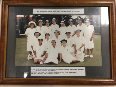
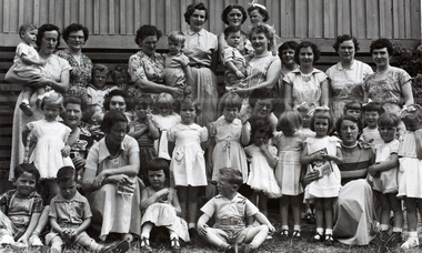
Photograph, VLBA Metropolitan Pennant Section Winners Division A2, 1997
Sports Clubs in Kew in the final decades of the 19th century and in the early 20th century were often umbrella organisations with facilities for a number of sports. Typically in Kew, this included teams in lawn bowls, tennis and croquet. The Kew Bowling Club was formed in 1880 while the privately owned Auburn Heights Recreation Club was opened in 1904. By 1998, the two Clubs decided to amalgamate at the Auburn Heights site in Barkers Road, forming the Kew Heights Sports Club. The combined club was itself taken over by the Melbourne Cricket Club in 2012 becoming MCC Kew Sports Club. In 2017 MCC Kew closed and its landholding was subsequently sold to Carey Baptist Grammar School. Both the Kew and Auburn Heights Clubs assembled important collections. These historically significant and large collections were donated to the Society in 2020. The collections include manuscripts, pictures, trophies, plans, honour boards etc. The combined collections of the four sporting clubs making up the collection number hundreds of items that are historically significant locally. They are also significant to the sporting history of the greater Melbourne area and to the sports of lawn bowls and tennis in Australia in the 19th and 20th centuries. The collection illuminates two of the Victorian historic themes - 'Building community life' through forming community organisations and 'Shaping cultural and creative life' by participating in sport and recreation.Framed and glazed colour photograph of the Kew Ladies Bowling Club team which won the VLBA Division A2 pennant in 1996-7kew bowling club, kew ladies bowling club, sports - kew (vic) -
 The Beechworth Burke Museum
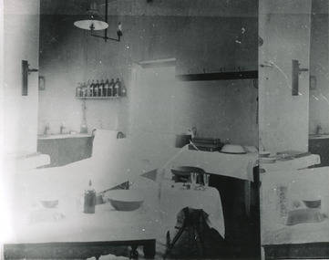
Photograph, c. 1910
Taken approximately 1910, this black and white photograph shows the interior of the surgery and consulting rooms at the Mayday Hills mental hospital known at that time as a lunatic asylum in Beechworth. Mayday Hills Hospital, then known as the Beechworth Lunatic Asylum was constructed between 1864-67 designed by The Public Works Department. The hospital is made up of a number of buildings, landscaping, ha-ha, workshops, laundry, administrative facilities and farmland, it was constructed in 'Italianate' style by a team of up to two hundred and fifty workers (Woods p. 122). The asylum was established in response to the need for the regional shire to locally care for those particularly affected by their time working the Ovens goldfield during the Indigo Shire gold rush era where poor living conditions and isolation were significantly affecting the welfare of a great many people through poverty and lack of resources. The gaol and orphan labour systems were not able to effectively support to give housing, rehabilitation and ongoing care for the mentally ill, and transporting to Melbourne by waggon was a time consuming and counter-productive solution when the metro facilities were already overcrowded. According to Woods (A Titan's Field p. 122), between 1901 and 1911 a large percentage (thirty five percent in 1901 and twenty four in 1911) of the Beechworth population were either patients or inmates of Beechworth institutions, Mayday Hills accounted for some six hundred and seventy four patients in 1901, Beechworth's Mayday Hills was chosen as the site of Victoria's newest asylum, at the time, due to the landscape and altitude. The hilltop atmosphere and the native fauna, it was argued, would assist in the cure of the patients kept at the hospital (Wood 1985, 122). The positioning of the hospital had a beneficial effect on the rural town and the large volume of people living at the hospital and contributing to this population growth is counted as reason for the survival of Beechworth as a regional township. Mayday Hills continued to function as a mental hospital up until 1995 when it was sold to LaTrobe university. The building and grounds are listed on the Victorian Heritage Register under criterion A, B, D, E and F. Although grainy, the image gives a good indication of a functioning interior space of a surgery and consulting room at Mayday Hills in the early 1900's, from which we might interpret (from the types of tools and furniture present), the medical practices being performed at the time.Black and white rectangular photographmedical, asylum, surgery, hospital, beechworth, mayday hills, mayday hills asylum, mayday hills hospital, mental hospital, beechworth lunatic asylum, beechworth institutions, social welfare, public works department, consulting room -
 The Beechworth Burke Museum
Photograph, 1960s
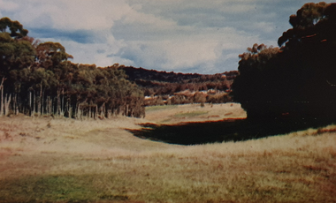
This photo was taken in the 1960s from a northeast position looking down towards Lake Sambell, the caravan park, and the surrounding area. This photo was taken during a period of rejuvenation for the lake area including the opening of the caravan park in 1959 and the swimming pool area in 1961 (this pool is just visible in the centre of the photo). The popularity of caravanning in Australia exploded during this post-war period of the late 1950s and 1960’s. This popularity was driven by multiple factors, including: the stopping of fuel rations, the accessibility of car ownership through the manufacturing of affordable cars, technological developments in caravan design, and the increase in prosperity and leisure time for many Australians. Lake Sambell is an artificial lake that was developed on the previous site of the Rocky Mountain Mining Company workings and was officially opened by Minister for Lands, Mr Baily, on October 5, 1928. The disused and unattractive remains of the mine were converted into a recreational area intended for swimming, boating, and fishing. The lake is named after Mr L.H. Sambell, shire engineer and secretary of the Forward Beechworth Committee, who advocated for the enhancement of Beechworth into a tourist destination and was central to the planning and establishment of the lake. Funding for the project was raised by both competition funds and donations. Since the construction in 1928 several engineering issues have arisen. In 1939 the water levels were low, and the lake was considered both an eyesore and ‘mudhole’, Beechworth Shire Council sort funding to raise the height of the lake six feet to improve the quality of water. Throughout the 1940s the Beechworth Swimming Club tried to raise awareness and funds to address the structural engineering issues and improve swimming facilities at the lake. R.E. Carter, similar to L.H. Sambell, was a shire engineer who advocated the importance of positioning Beechworth as a tourist destination. Carter held the position from 1954-63 and organised many improvements to the Lake Sambell area including the caravan park in 1959, the lake swimming pool in 1961, water skiing and boating facilities, and increased the lake surface are in 1964. These improvements were financed mainly by grants from the Tourist Development Authority. This photograph is of historical significance as it documents Lake Sambell and the surrounding area in the 1960s after a phase of enhancements to improve the appearance and usability for both the people of Beechworth and tourists. It is also of social significance in providing an insight into the increase in leisure time and access to travel during a period of post-war prosperity.Black and white rectangle photograph printed on matte photographic paper and unmounted.Reverse: 1 / [logo KODAK/ VELOX/ PAPER] / C798 / 3535lake sambell, lake sambell caravan park, lake sambell swimming pool, caravan park, caravanning 1960s, rocky mountain mining company, l.h. sambell, r.e. carter, beechworth swimming club, forward beechworth committee, minister of lands, tourist development authority, lake swimming, swimming, boating, fishing, water skiing, beechworth 1960s, lake sambell fishing, lake sambell boating -
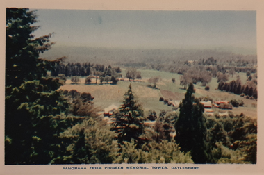
 Ballarat Heritage Services
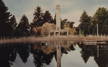
Photograph, Nucolorvue, Daylesford Pioneer Tower in Wombat Garrdens, 1957
Daylesford is a tourist town in Central Victorian, known for its mineral water springs.Image of the Daylesford Pioneer Memorial Tower in Wombat Gardens, Daylesford.Daylesford, Victoria, Australia This famous holiday resort is famous for its up-to-date facilities, as well as for its natural attractions. The mineral Springs are renowned for their high medicinal elements. The visitor finds ample to amuse, in excellent fishing, boating, Boating, Swimming, golfing, hiking and riding. The district provides a wide range of typical Australian bush scenery, and the altitude of 2,000 feet above sea level as a tonic effect on all. Daylesford has modern hotels, guest houses, shops and places of amusement, also many other places of interest within short travelling distance. Bendigo, 50 miles, Ballara 30 miles, and Melbourne 75 miles, bring Daylesford within easy reach of many parts of Victoria. daylesford, pioneer tower, wombat gardens -
 Ballarat Heritage Services
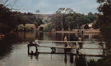
Photograph, Nucolorvue, A Corner of Jubilee Lake, Daylesford, 1957
Daylesford is a tourist town in Central Victorian, known for its mineral water springs.Image of Jubilee Lake, Daylesford.Daylesford, Victoria, Australia This famous holiday resort is famous for its up-to-date facilities, as well as for its natural attractions. The mineral Springs are renowned for their high medicinal elements. The visitor finds ample to amuse, in excellent fishing, boating, Boating, Swimming, golfing, hiking and riding. The district provides a wide range of typical Australian bush scenery, and the altitude of 2,000 feet above sea level as a tonic effect on all. Daylesford has modern hotels, guest houses, shops and places of amusement, also many other places of interest within short travelling distance. Bendigo, 50 miles, Ballara 30 miles, and Melbourne 75 miles, bring Daylesford within easy reach of many parts of Victoria. daylesford, jubilee lake, pier -
 Ballarat Heritage Services
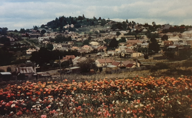
Photograph, Nucolorvue, Panorama Looking Towards Wombat Hill at Daylesford, 1957
Daylesford is a tourist town in Central Victorian, known for its mineral water springs.Panorama Looking Towards Wombat Hill at DaylesfordDaylesford, Victoria, Australia This famous holiday resort is famous for its up-to-date facilities, as well as for its natural attractions. The mineral Springs are renowned for their high medicinal elements. The visitor finds ample to amuse, in excellent fishing, boating, Boating, Swimming, golfing, hiking and riding. The district provides a wide range of typical Australian bush scenery, and the altitude of 2,000 feet above sea level as a tonic effect on all. Daylesford has modern hotels, guest houses, shops and places of amusement, also many other places of interest within short travelling distance. Bendigo, 50 miles, Ballara 30 miles, and Melbourne 75 miles, bring Daylesford within easy reach of many parts of Victoria. daylesford, wombat hill, flora -
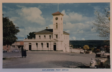 Ballarat Heritage Services
Photograph, Nucolorvue, Daylesford Post Office, 1957
Daylesford is a tourist town in Central Victorian, known for its mineral water springs.View of the Daylesford Post OfficeDaylesford, Victoria, Australia This famous holiday resort is famous for its up-to-date facilities, as well as for its natural attractions. The mineral Springs are renowned for their high medicinal elements. The visitor finds ample to amuse, in excellent fishing, boating, Boating, Swimming, golfing, hiking and riding. The district provides a wide range of typical Australian bush scenery, and the altitude of 2,000 feet above sea level as a tonic effect on all. Daylesford has modern hotels, guest houses, shops and places of amusement, also many other places of interest within short travelling distance. Bendigo, 50 miles, Ballara 30 miles, and Melbourne 75 miles, bring Daylesford within easy reach of many parts of Victoria. daylesford, daylesford post office -
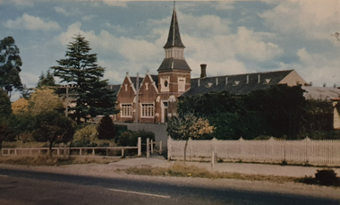 Ballarat Heritage Services
Photograph, Nucolorvue, Daylesford Primary School, 1957
Daylesford is a tourist town in Central Victorian, known for its mineral water springs.View of the Daylesford Primary SchoolDaylesford, Victoria, Australia This famous holiday resort is famous for its up-to-date facilities, as well as for its natural attractions. The mineral Springs are renowned for their high medicinal elements. The visitor finds ample to amuse, in excellent fishing, boating, Boating, Swimming, golfing, hiking and riding. The district provides a wide range of typical Australian bush scenery, and the altitude of 2,000 feet above sea level as a tonic effect on all. Daylesford has modern hotels, guest houses, shops and places of amusement, also many other places of interest within short travelling distance. Bendigo, 50 miles, Ballara 30 miles, and Melbourne 75 miles, bring Daylesford within easy reach of many parts of Victoria. daylesford, daylesford primary school, primary state school -
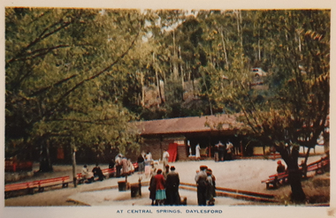 Ballarat Heritage Services
Photograph, Nucolorvue, Central Springs Daylesford, 1957
Daylesford is a tourist town in Central Victorian, known for its mineral water springs.Central Springs DaylesfordDaylesford, Victoria, Australia This famous holiday resort is famous for its up-to-date facilities, as well as for its natural attractions. The mineral Springs are renowned for their high medicinal elements. The visitor finds ample to amuse, in excellent fishing, boating, Boating, Swimming, golfing, hiking and riding. The district provides a wide range of typical Australian bush scenery, and the altitude of 2,000 feet above sea level as a tonic effect on all. Daylesford has modern hotels, guest houses, shops and places of amusement, also many other places of interest within short travelling distance. Bendigo, 50 miles, Ballara 30 miles, and Melbourne 75 miles, bring Daylesford within easy reach of many parts of Victoria. daylesford, central springs, mineral water, mineral water springs, kiosk -
 Ballarat Heritage Services
Photograph, Nucolorvue, Panorama from the Pioneed Memorial Tower, Daylesford, 1957
Daylesford is a tourist town in Central Victorian, known for its mineral water springs.Central Springs DaylesfordDaylesford, Victoria, Australia This famous holiday resort is famous for its up-to-date facilities, as well as for its natural attractions. The mineral Springs are renowned for their high medicinal elements. The visitor finds ample to amuse, in excellent fishing, boating, Boating, Swimming, golfing, hiking and riding. The district provides a wide range of typical Australian bush scenery, and the altitude of 2,000 feet above sea level as a tonic effect on all. Daylesford has modern hotels, guest houses, shops and places of amusement, also many other places of interest within short travelling distance. Bendigo, 50 miles, Ballara 30 miles, and Melbourne 75 miles, bring Daylesford within easy reach of many parts of Victoria. daylesford, wombat gardens, wombat hill gardens, daylesford pioneer memorial tower, landscape -
 Ballarat Heritage Services
Photograph, Nucolorvue, First Fairway of Golf Course, Hepburn, 1957
Daylesford is a tourist town in Central Victorian, known for its mineral water springs.The first course at the Hepburn Golf Club.Daylesford, Victoria, Australia This famous holiday resort is famous for its up-to-date facilities, as well as for its natural attractions. The mineral Springs are renowned for their high medicinal elements. The visitor finds ample to amuse, in excellent fishing, boating, Boating, Swimming, golfing, hiking and riding. The district provides a wide range of typical Australian bush scenery, and the altitude of 2,000 feet above sea level as a tonic effect on all. Daylesford has modern hotels, guest houses, shops and places of amusement, also many other places of interest within short travelling distance. Bendigo, 50 miles, Ballara 30 miles, and Melbourne 75 miles, bring Daylesford within easy reach of many parts of Victoria. daylesford, fairway, hepburn golf course -
 Ballarat Heritage Services
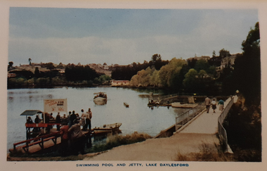
Photograph, Nucolorvue, Swimming Pool and Jetty, Lake Daylesford, 1957
Daylesford is a tourist town in Central Victorian, known for its mineral water springs.Swimming Pool and Jetty, Lake DaylesfordDaylesford, Victoria, Australia This famous holiday resort is famous for its up-to-date facilities, as well as for its natural attractions. The mineral Springs are renowned for their high medicinal elements. The visitor finds ample to amuse, in excellent fishing, boating, Boating, Swimming, golfing, hiking and riding. The district provides a wide range of typical Australian bush scenery, and the altitude of 2,000 feet above sea level as a tonic effect on all. Daylesford has modern hotels, guest houses, shops and places of amusement, also many other places of interest within short travelling distance. Bendigo, 50 miles, Ballara 30 miles, and Melbourne 75 miles, bring Daylesford within easy reach of many parts of Victoria. daylesford, swimming pool and jetty, lake daylesford, swimming -
 Ballarat Heritage Services
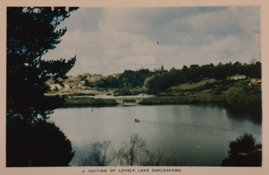
Photograph, Nucolorvue, A Section of Lake Daylesford, 1957
Daylesford is a tourist town in Central Victorian, known for its mineral water springs.A Section of Lake DaylesfordDaylesford, Victoria, Australia This famous holiday resort is famous for its up-to-date facilities, as well as for its natural attractions. The mineral Springs are renowned for their high medicinal elements. The visitor finds ample to amuse, in excellent fishing, boating, Boating, Swimming, golfing, hiking and riding. The district provides a wide range of typical Australian bush scenery, and the altitude of 2,000 feet above sea level as a tonic effect on all. Daylesford has modern hotels, guest houses, shops and places of amusement, also many other places of interest within short travelling distance. Bendigo, 50 miles, Ballara 30 miles, and Melbourne 75 miles, bring Daylesford within easy reach of many parts of Victoria. daylesford, swimming, lake daylesford -
 Ballarat Heritage Services
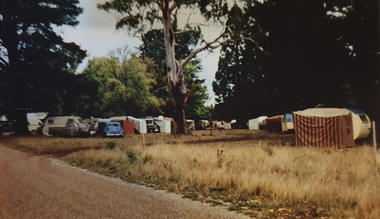
Photograph, Nucolorvue, Caravans in Victoria Park Camping Ground, Daylesford, 1957
Daylesford is a tourist town in Central Victorian, known for its mineral water springs.Caravans in Victoria Park Camping Ground, DaylesfordDaylesford, Victoria, Australia This famous holiday resort is famous for its up-to-date facilities, as well as for its natural attractions. The mineral Springs are renowned for their high medicinal elements. The visitor finds ample to amuse, in excellent fishing, boating, Boating, Swimming, golfing, hiking and riding. The district provides a wide range of typical Australian bush scenery, and the altitude of 2,000 feet above sea level as a tonic effect on all. Daylesford has modern hotels, guest houses, shops and places of amusement, also many other places of interest within short travelling distance. Bendigo, 50 miles, Ballara 30 miles, and Melbourne 75 miles, bring Daylesford within easy reach of many parts of Victoria. daylesford, victoria park caravan park, camping, victoria park, caravan park -
 Ballarat Heritage Services
Photograph, Nucolorvue, Vincent Street Daylesford Looking Towards Hepburn Springs, 1957
Daylesford is a tourist town in Central Victorian, known for its mineral water springs.Vincent Street Daylesford Looking Towards Hepburn SpringsDaylesford, Victoria, Australia This famous holiday resort is famous for its up-to-date facilities, as well as for its natural attractions. The mineral Springs are renowned for their high medicinal elements. The visitor finds ample to amuse, in excellent fishing, boating, Boating, Swimming, golfing, hiking and riding. The district provides a wide range of typical Australian bush scenery, and the altitude of 2,000 feet above sea level as a tonic effect on all. Daylesford has modern hotels, guest houses, shops and places of amusement, also many other places of interest within short travelling distance. Bendigo, 50 miles, Ballara 30 miles, and Melbourne 75 miles, bring Daylesford within easy reach of many parts of Victoria. daylesford, vincent street, streetscape -
 Bendigo Historical Society Inc.
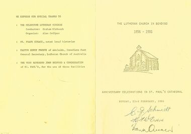
Document - THE LUTHERAN CHURCH IN BENDIGO, 1986
The Lutheran Church in Bendigo 1856 - 1986. 43 (Corner of Galvin Street and Barry Street, Bendigo. Red Brick with white trimmings.) Anniversary Celebrations in St. Paul's Cathedral, Sunday, 23rd February, 1986. Introduction: Clem Schmidt, Lutheran Pastor at Bendigo. Henry Prove: The Lutheran Church of Australia - Its development in the first five decades. Frank Cusack: The German contribution to early Bendigo. We express out special thanks to: The Melbourne Lutheran Singers, Conductor: Graham Wiebusch, Organist: Alan Collyer : Mr Frank Cusack, noted local historian : Pastor Henry Proeve of Adelaide, Immediate Past General Secretary, Lutheran Church of Australia : The Very Reverend John Bedford & Congregation of St. Paul's, for the use of these facilities. Markings: signatures of C J Schmidt, H J W Proeve, Frank Cusack. First 2 in blue pen 3rd in black pen.church, celebration, anniversary celebrations, the lutheran church 1856 - 1986. 43 galvin and barry street, . red white trimmings.) anniversary celebrations st. paul's cathedral, 23rd feb, 1986. clem schmidt, lutheran pastor. henry prove: the lutheran church of australia development decades. frank cusack: the german contribution: melbourne lutheran singers, conductor: graham wiebusch, organist: alan collyer : immediate past general secretary, lutheran church of australia : the very reverend john bedford & congregation of st. paul's, markings signatures c j schmidt, h j w proeve, frank cusack -
 Falls Creek Historical Society
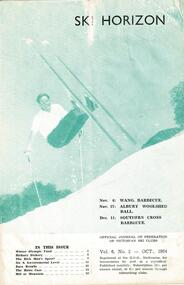
Journal - Ski-Horizon Vol 6 No 2
Ski-Horizon is the official journal of the Federation of Victorian Ski Clubs which began publication in 1949. The were 26 original member clubs which included Albury Ski Club, Bogong Ski Club, Myrtleford Ski Club, Tallangatta and District Ski Club and Wangaratta Ski Club. Two pioneers of Falls Creek, Tom Mitchell, M.L.A., and Martin Romuld were Vice-Presidents of the Federation.This Journal is significant because it documents the early development of skiing in Victoria.The journal features stories and events chronicling developments in Victoria and internationally. Items related to the Falls Creek Area in this issue include:- Cover - Rudi Wurth, winner of the National Slalom and Downhill titles at Kosciusko, 1954. Page 3 - Commercial ventures are prospering in Falls Creek. Plans ahead for developments at Nissen Tow. Betty Plunkett will spend the year on the snow helping Skippy with the canteen. Les Mikel will help Toni with the tow. Bob Hymans and his wife leave for Europe soon to get fresh ideas and equipment. Bob intends to install a £15,000 chair lift with special cable which allow it to go round corners. Page 5 - Fred Griffith, President of the Falls Creek Alpine Village Advisory Committee has been in Melbourne lobbying for Government help to build a comfort station to provide facilities for a ski patrol shelter - aided and abetted by a "well known skiing M.L.A. toni st. elmo, skippy st. elmo, bob hymans, nissen ski tow, fred griffith -
 Ringwood and District Historical Society
Document - Folder, Land Sale - Monterey Park Subdivision, Warrandyte Road, Ringwood North, Vic. - 1981
Foolscap manilla folder containing double-sided flyer advertising residential subdivision development, including outline of local facilities and services, with locality map and layout of Monterey Park streets. Subdivision includes Parkwood High School, Tortice Drive, Heape Way, Appleberry Place, Stringybark Court, Conifer Court, Crawley Grove, Monterey Close (later Monterey Place), Lucy Place, Middlebrook Drive, Gahnia Close, Glanfield Court, Cone Close, Jull Parade, Pinus Close (later Pinetree Court), Radiata Close, Old Warrandyte Road, and entry from Warrandyte Road. Vendor - Jennings Industries Limited, 690 Springvale Road, Mulgrave, 3170, Phone 5618000. A4 enclosures with tables showing each allotment List Price, Builders Price, Cash Price and Terms Price. Information page headed "Form of Restrictive Covenant to be incorporated in Transfer" specific to Certificates of Title. Restrictive Covenant (summary): (Name/s) "... will not erect or construct or cause to be erected or constructed on the land hereby transferred (a) Any front boundary fence, other than a fence which does not exceed one metre in height unless the same is set back as least 1.5 metres from the front boundary and the same is effectively screened from that boundary by the planting of trees, shrubs or plants. (b) Any side boundary fence other than a fence which is set back at least 1.5 metres from the front boundary on which does not exceed 1 metre in height within 1.5 metres of the front boundary. (c) For a period of 5 years from the date hereof, any building on the said land unless and until the Plans and Specifications thereof have first been approved by the said Residential Developments Pty. Limited. (d) For a period of 2 years from the date hereof whilst the said land remains vacant any Signboard or Notice advertising the sale of the said lot or any other lot. These covenants shall appear on the Certificate of Title to issue for the said land and run with the land." -
 Orbost & District Historical Society
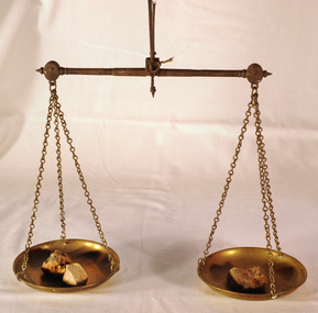
scales, Circa 1850's
Scales were used in the Tarnagulla area of Central Victoria by Albert Charles Nicholls, who was a licensed assayer. This information comes from David Gordon of the Tarnagulla.com web-site. “The Nicholls family were very well known and highly respected at Tarnagulla in the 1800s. Albert's father, William Nicholls, was a leading figure in the gold mining community, and he both managed and owned quartz processing facilities for decades. He was probably the leading mining expert at Tarnagulla in a town full of mining experts, and it was said that no man at Tarnagulla had handled more gold over the years that him. (think in terms of tons of gold!) I would imagine the assaying equipment was probably passed in due course by William to Albert Charles. There are records of Albert Charles mining at Tarnagulla with his father as a young man, but AC apparently came down to the city when the gold began to fade. There are records of him living in Kew up until his death in 1932. He was employed as a draper for a long period.” This item is a significant item which is part of the history of gold mining in Victory.Gold assayer's scales, a very sensitive balance used in the assaying of gold, silver, etc.The scales are comprised of two circular brass pans suspended via brass chains to a metal balance.scales gold technology assayers tarnagulla -
 Glen Eira Historical Society
Document - Hopetoun Street, 10, Elsternwick
Three items relating to valuations for this property: 1/One page typed letter from Weigall and Crowther Solicitors to S P Simmonds Estate Agency on behalf of Flora Lee, dated 03/10/1962, requesting valuation of 10 Hopetoun Street, Elsternwick re the Estate of G R Lee. 2/Four page typed valuation of 10 Hopetoun Street, Elsternwick, by Edward J K Callaghan, dated 10/10/1962. The valuation includes property measurements, title particulars, zoning, detailed information about the facilities in the surrounding area and also expansive details about the house on the property and other improvements. 3/Copy of a two page typed letter, from valuator WV Scott to George Lee, dated 22/12/1971, to Mr George Lee providing another later valuation of 10 Hopetoun Street, Elsternwick re the Estate late Flora Lee. Accompanying is a one page handwritten, undated and unattributed document of working notes.lee flora, lee george ralph, hopetoun street, elsternwick, weatherboard house, garages, korong road, king street, glenhuntly road, morton street, orong road, orrong road, kooyong road, lee george, callaghan edward j k, s p simmonds real estate agents auctioneer, scott w v, timber houses, murray street -
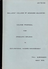 Federation University Historical Collection
Document - Document - Booklet, VIOSH: Ballarat College of Advanced Education: Course Proposal for Graduate Diploma in Occupational Hazard Management; Full Submission; March 1978
Victorian Institute of Occupational Safety and Health (VIOSH) Australia is the Asia-Pacific centre for teaching and research in occupational health and safety (OHS) and is known as one of Australia's leaders on the field. VIOSH has a global reputation for its innovative approach within the field of OHS management. VIOSH had its first intake of students in 1979. At that time the Institution was known as the Ballarat College of Advanced Education. In 1990 it became known as Ballarat University College, then in 1994 as University of Ballarat. It was 2014 that it became Federation University. VIOSH Australia students are safety managers, senior advisors and experienced OHS professionals. They come from all over Australia and industry. Students are taught active research and enquiry; rather than textbook learning and a one-size fits all approach. VIOSH accepts people into the Graduate Diploma of Occupational Hazard Management who have no undergraduate degree - on the basis of extensive work experience and knowledge. Booklet outlines the course need and descripton of course, staffing and facilities required.Stapled and tape bound booklet with pale blue paper cover. Contents - 15 pages; appendix cover various sections. Blue back cover removed.Stamped in top right corner: AB 78/3Aviosh, victorian institute of occupational safety and health, graduate diploma in occupational hazard management, submission, school of engineering, ballarat college of advanced education -
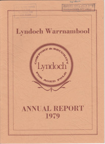 Warrnambool and District Historical Society Inc.
Document - Lyndoch Warrnambool 1979 Annual Report, 1979
This is the 1979 Annual Report for Lyndoch Home and Hospital for the Aged, Warrnambool. It contains lists of Board Members, a President’s Report, a sketch of a proposed new building, financial reports, photographs and a list of Life Governors. Lyndoch Home for the Aged was established in 1952 and has developed with a wide range of facilities for the aged since that date. The original Lyndoch property near the mouth of the river Hopkins was owned by a Melbourne tea merchant, George Rolfe, who bought the land when there were only on the site a couple of cottages and a larger building which had been a school, Warrnambool Grammar, run by Henry Kemmis. Rolfe acquired the land in the 1870s and named the property Lyndoch after the town in the Barossa Valley where he had lived. He owned Lyndoch for 44 years and it was his stepdaughter, Florence Lake who built in the 1920s the bungalow known as Lyndoch which forms the original building of the Lyndoch Home for the Aged. Today the facility is called Lyndoch Living.This report is kept for the benefit of researchers wanting details of the history of Lyndoch over the past thirty or forty years.This is a booklet with a cardboard buff-coloured cover. There are six double-sided pages with printed material on white paper with a yellow and orange stripe across the top of the pages.On front cover: Lyndoch Warrnambool, Annual Report 1979 In brown circle on front cover: Lyndoch, Comfort and Security for Aged Folk Two library stamps on front cover (Warrnambool Library) lyndoch, aged care facility, warrnambool, hopkins, warrnambool grammar -
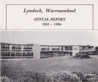 Warrnambool and District Historical Society Inc.
Document - Lyndoch Warrnambool Annual Report 1985-86, 1986
This is the 1985-6 Annual Report for Lyndoch Home and Hospital for the Aged, Warrnambool. It contains lists of Board Members, a President’s Report, photographs, Lyndoch’s Aims, financial reports and a list of Life Governors. Lyndoch Home for the Aged was established in 1952 and has developed with a wide range of facilities for the aged since that date. The original Lyndoch property near the mouth of the River Hopkins was owned by a Melbourne tea merchant, George Rolfe, who bought the land when there were on the site only a couple of cottages and a larger building which had been a school, Warrnambool Grammar, run by Henry Kemmis. Rolfe acquired the land in the 1870s and named the property Lyndoch after the town in the Barossa Valley where he had lived. He owned Lyndoch for 44 years ad it was his stepdaughter Florence Lake who built in the 1920s the bungalow known as Lyndoch which forms the original building of Lyndoch Home for the Aged. Today the facility is called Lyndoch Living. This 1985-6 report is kept for the benefit of researchers wanting details of the history of Lyndoch over the past 30 or 40 years.This is a booklet with a plasticized white cover with a black and white photograph of a Lyndoch building on the front cover. There are eight double-sided pages with printed material and photographs. The pages are stapled.On front cover: ‘Lyndoch, Warrnambool, Annual Report, 1985-1986 On back cover: A black circle with the words: ‘Lyndoch, Comfort and Security for Aged Folk’. lyndoch aged care facility, warrnambool -
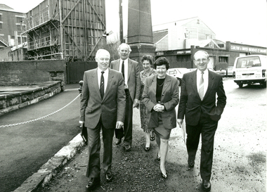 Federation University Historical Collection
Photograph - Photograph - Black and White, Premier Joan Kirner visits the Ballarat School of Mines, August 1991, 08/1991
Before her marriage to Ron Kirner, Joan Hood taught at the Ballarat Girls' Junior Technical School in the late 1950s. The Girls' school was a division of the Ballarat School of Mines. After entering politics Joan Kirner was Minister for Education (1988) and Premier of Victoria (1990 to 1992). In 1992 Premier of Victoria Joan Kirner visited her former workplace to officially open and name four new facilities, marking stage 2 of the school's State Works and Services Development Project. Honoured in the naming ceremony was the late Albert Steane, the late Kenneth Fleckoe and Mr Jack Barker, President of the Ballarat School of Mines. The fourth facility was the recently opened carpentry and joinery complex. Mrs Kirner said naming the building in honour of the three men would act as a continual reminder of their contribution to education in Australia and what they have passed on to future generations. She said the Government and the State Training Board saw the college as not only one that was most important to Victoria but also nationally and internationally. A group of 5 people walking along Ballarat's Lydiard Street South. The former Ballarat Brewery in the background is in the process of being demolished to make way for an expansion of the SMB campus. Left to right: Peter Shiells, E.J. (Jack) Barker, Winsome Barker, Premier of Victoria Joan Kirner, Frank Sheehan MLA (Labor State Member for Ballarat South). joan kirner, joan hood, ballarat junior technical girls' school, e.j. barker, peter shiells, frank sheehan -
 Melbourne Water
Photograph, Upper Yarra Dam Personnel, 1955
As the Yarra became unsuitable as a source of water, several attempts were made to find alternative sources for the growing population of Melbourne. It was not until 1891 that the efforts to sewer Melbourne came to fruition with the setting up of the Melbourne Metropolitan Board of Works (MMBW), now known as Melbourne Water. From 1891 until 1992, it was the responsibility of the MMBW to safeguard public health by providing a sewerage system and a safe water supply system. In 1992, The MMBW merged with a number of smaller urban water authorities to form Melbourne Water. In 1946, the Melbourne and Metropolitan Board of Works (MMBW) approved a site for a new dam for Melbourne's domestic water. This is now known as the Upper Yarra Dam. Due to the construction of the dam, the workforce had to be accommodated on site; domestic quarters were built for single men, families and staff. The township also had kitchens, laundry facilities, a canteen, a recreation hall, mess areas and a co-op store, with one of the first houses being seconded to accommodate for a school. This photograph shows personnel at a Kindergarten party at the Upper Yarra Dam, a time where workers were housed during its construction. The photograph is historically significant as it captures a purpose built community that supported the workers undertaking the construction of the dam. upper yarra dam, mmbw, melbourne metropolitan board of works, township, 1940s, community -
 Otway Districts Historical Society
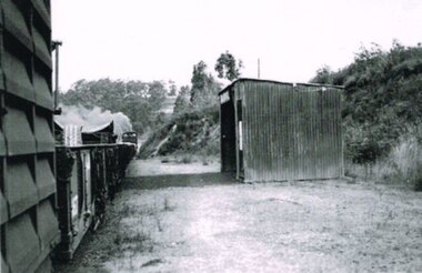
Photograph, Banool Station, c.1940, c.1940
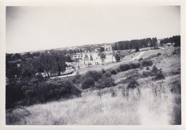
Originally known as "Moorbanool" after the local parish, the name was shortened to Banool on 1 November 1904. At first facilities consisted of a loop siding for eleven trucks and a passenger shelter, plus a residence for the ganger for the track gang based there. Increasing train services on the line required a crossing station in this section of track, so in 1913 Banool became a 'Staff & Ticket' station with a crossing loop, home signals, and a station office, although this only lasted two years. Loading statistics showed that in most years the outwards tonnage at Banool was less than 150 tonnes. From 1924 the amount of timber despatched began a slow rise, but apart from a few years activity was generally slack. The crossing loop, the usually empty goods loop being used if necessary, the home signals and its status as a staff station being removed over the period 1923-27. The track ganger shelter was removed around 1929 and the station reduced to a passenger shelter and goods loop only.B/W. A goods train passing Banool Station, c.1940. -
Vision Australia
Text, RVIB Woodend Auxiliary, 1929 - [2000?]
The Woodend RVIB Auxiliary formed on November 8, 1929. This small collection contains index cards which were maintained by RVIB and contain the amount of donations made by the Auxiliary between 1976 - 1995 as well as the presentations delivered by RVIB employees to Auxiliary meetings between 1973 - 1985. Correspondence to and from RVIB head office ranging between 1990 - 2000. Newspaper article from 1990 'RVIB honour'; The Gisborne and Woodend auxiliaries of the RVIB have been invited to the unveiling of two plaques made in honour of the late Miss Betty Ross Watt and the late Mrs Caroline Mary Goldie at RVIB in St. Kilda Road. These ladies were foundation members of the Gisborne and Woodend auxiliaries respectively, and they worked hard and inspired others for over 50 years. As a result of their generous bequest to the institute, four sound-proofed recording studios have been completed. Other funds donated by the two women have been used for the extensions of the RVIB talking book library building and additions to library facilities. Letters -- newspaper clippings -- index cards and various loose papers royal victorian institute for the blind -
 Surrey Hills Historical Society Collection
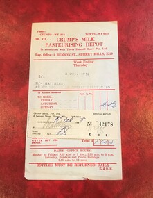
Document - Account and receipt, Receipt signed (?) ES - possibly Eric Scanlan, Crump's Milk Pasteurising Depot account with attached receipt, 2 October 1958 /6 October 1958
Crumps Dairy (Milk Pasteurising Depot) was located at 6 Benson Street, Surrey Hills on the corner of Weybridge Street until c1973. It was demolished after it had been badly vandalised. The business closed after cartons replaced glassperishables including milk, bread, meat and fruit and vegetables bottles for sale of milk. It was one of many small local facilities for processing and delivering milk that existed from the early 1920s. Eric William Walker Crump (1903-1981) headed the family business. Also involved were Kevin Eric Crump, Eric William Scanlan. NB/ Also held in this collection is a copy of a project by Chatham Primary School student, Susanne Pascoe, dated 1956 which includes photos of the dairy's operations. An oral history by Dave Croft, a driver for the dairy, who lived close by, is also relevant. The account also mentions 'Towt'. Canterbury Oliver Towt (1890-1962) was another dairyman whose premises was on the corner of Chatham and Mont Albert Roads.This is material evidence of business practice c1920s-1960s when accounts for goods received, especially perishables, were often hand-delivered on a weekly basis, with monies owed collected at the door. A paper account printed red on cream (discoloured) paper with the details of the date, account holder and address typed in and the amount owed hand-written in blue ink. The attached receipt has been stuck onto the account and filled out in grey pencil and blue ink. The amounts are in pounds, shillings and pence.Typed: 2/1; 2 OCT. 1958 M/- MATTHEWS, 42 GUILDFROD RD. SURREY HILLS, E.10dairies, crumps dairy, crumps milk pasteurising depot, kevin eric crump, eric william scanlan, eric william walker crump, towt's dairy, canterbury oliver towt, accounts, receipts, guildford road, geoff matthews, ruth matthews, benson street, towts rosehill dairy