Showing 6446 items matching " housing"
-
 Eltham District Historical Society Inc
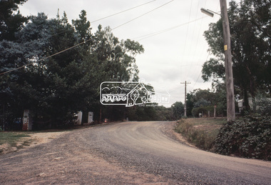
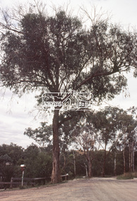
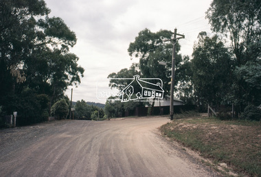
Slide, Adam Crescent, Montmorency, c. Feb. 1981
One of a series of images of road infrastructure focussed on Adam Crescent in Montmorency taken by Eltham Shire Council Planning and Engineering officers. They provide perspective of the changes in housing styles and road development that began sweeping in from the mid 1970s with increasing urbanisation of what was once more outlying suburbs and regions. All images have been identified with GPS though house numbers have changed35 mm colour positive transparency (1 of 21) Mount - Kodak Kodachrome CardProcessed Feb 1981adam crescent, infrastructure, montmorency, roads -
 Eltham District Historical Society Inc
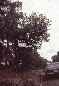
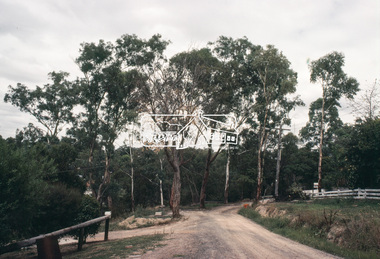
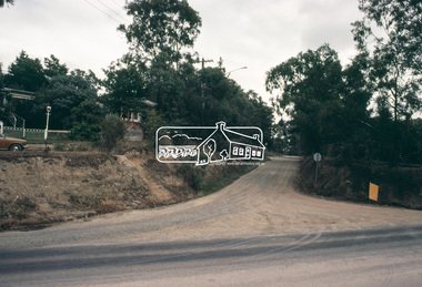
Slide, Adam Crescent, Montmorency, c. Feb. 1981
One of a series of images of road infrastructure focussed on Adam Crescent in Montmorency taken by Eltham Shire Council Planning and Engineering officers. They provide perspective of the changes in housing styles and road development that began sweeping in from the mid 1970s with increasing urbanisation of what was once more outlying suburbs and regions. All images have been identified with GPS though house numbers have changed35 mm colour positive transparency (1 of 21) Mount - Kodak Kodachrome CardProcessed Feb 1981adam crescent, infrastructure, montmorency, roads, gordon grove -
 Eltham District Historical Society Inc
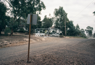
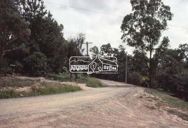
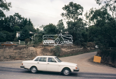
Slide, Adam Crescent, Montmorency, c. Feb. 1981
One of a series of images of road infrastructure focussed on Adam Crescent in Montmorency taken by Eltham Shire Council Planning and Engineering officers. They provide perspective of the changes in housing styles and road development that began sweeping in from the mid 1970s with increasing urbanisation of what was once more outlying suburbs and regions. All images have been identified with GPS though house numbers have changed35 mm colour positive transparency (1 of 21) Mount - Kodak Kodachrome CardProcessed Feb 1981adam crescent, infrastructure, montmorency, roads, gordon grove -
 Eltham District Historical Society Inc
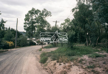
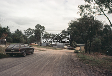
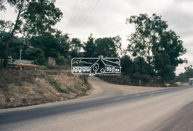
Slide, Adam Crescent, Montmorency, c. Feb. 1981
One of a series of images of road infrastructure focussed on Adam Crescent in Montmorency taken by Eltham Shire Council Planning and Engineering officers. They provide perspective of the changes in housing styles and road development that began sweeping in from the mid 1970s with increasing urbanisation of what was once more outlying suburbs and regions. All images have been identified with GPS though house numbers have changed35 mm colour positive transparency (1 of 21) Mount - Kodak Kodachrome CardProcessed Feb 1981adam crescent, infrastructure, montmorency, roads -
 Eltham District Historical Society Inc
Slide, Adam Crescent, Montmorency, c. Feb. 1981
One of a series of images of road infrastructure focussed on Adam Crescent in Montmorency taken by Eltham Shire Council Planning and Engineering officers. They provide perspective of the changes in housing styles and road development that began sweeping in from the mid 1970s with increasing urbanisation of what was once more outlying suburbs and regions. All images have been identified with GPS though house numbers have changed35 mm colour positive transparency (1 of 21) Mount - Kodak Kodachrome CardProcessed Feb 1981adam crescent, infrastructure, montmorency, roads, gordon grove -
 Eltham District Historical Society Inc
Slide, Adam Crescent, Montmorency, c. Feb. 1981
One of a series of images of road infrastructure focussed on Adam Crescent in Montmorency taken by Eltham Shire Council Planning and Engineering officers. They provide perspective of the changes in housing styles and road development that began sweeping in from the mid 1970s with increasing urbanisation of what was once more outlying suburbs and regions. All images have been identified with GPS though house numbers have changed35 mm colour positive transparency (1 of 21) Mount - Kodak Kodachrome CardProcessed Feb 1981adam crescent, infrastructure, montmorency, roads, sherbourne road -
 Hume City Civic Collection
Photograph, 1/08/1978
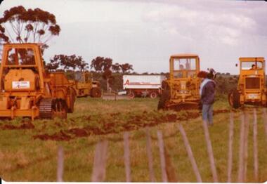
On 4th of August 1978 work began on the construction of the Goonawarra Estate on land that was the former Goonawarra Farm which overlooked the town of Sunbury abnd the Jacksons Creek valley. Plans for the new development included a golf course, houses, community and recreational facilities.The golf course openrd in 1980 and housing construction continued throughout the last two decades of the twentieth century and into the twentieth first century.A coloured photograph of the first sod being turned at the Goonawarra Estate. Four large pieces of earth-moving machinery and a large semi-trailer are in picture. A man is standing in the foreground.goona warra golf club, goonawarra farm, goonawarra housing estate, housing developments, sharkey, robert b., killkenny homes, australian ideas homes pty.ltd., craftsmen homes., glamor homes, villa bella homes, george evans collection -
 Stawell Historical Society Inc
Book - Report, Stawell Impact Study, 1985
Socio - Economic Impact of major Industrial development in stawell. Includes Population, Business, Community Welfare, Housing and Migration. This Study Suggested by Barry Clugston a a F.A.C.S. ( Family and Community Services) meeting around 1982 ( + _) funding via Town Council by a Government Grant. Committee formed to overview researchers work and suggest areas of Interest. Interest to release of publication at a high level by town and Community. Navy Card Front Grid: Grey Spine BindingStawell Impact Study Street Ryan & Asociates Pty Ltd. Development Consultants Inside: Barry Clugston June 1985stawell -
 Phillip Island and District Historical Society Inc.
Photograph, 1978/79
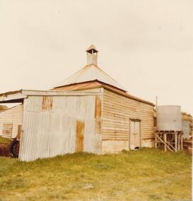
Chicory Kiln alongside the house of Mr T Woods in Settlement Road, East Cowes, was built in approx. 1870. It had 18" thick mud brick walls at the core.Photograph of Chicory Kiln on Settlement Road, East Cowes, on land owned by Mr. T. Woods.local history, photographs, buildings - historical, housing, rural industry, coloured photograph, john cook, phillip island, t woods -
 Phillip Island and District Historical Society Inc.
Photograph, 1978/79
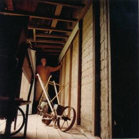
View of 18" thick mud brick walls in Chicory Kiln. This was built by Mr T Woods approx. 1870, Settlement Road, East Cowes. Two chicory sowers shown in photograph. Man in photograph is probably Mr T Woods.Photograph of the 18" thick mud brick walls at the core of the old Chicory Kiln on Mr T Woods house, Settlement Road, East Cowes.local history, photographs, buildings - historical, housing, rural industry, coloured photograph, john cook, phillip island, t woods -
 Eltham District Historical Society Inc
Book, Citymission Retirement Village - Judge Book Village, Eltham: A Village History; the first thirty years / The Reverend Norman C. Pearce, 1986
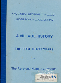
CityMission Retirement Village, also known as Eltham Retirement Centre, also formerly known as Judge Book Memorial Village, was officially opened on Sunday 28 October 1956. This history documents the first thirty years through to 1986. Founded by the Melbourne City Mission, the significant early history of the "village for the aged" is documented including the various challenges faced including ongoing expansions and building develoment needs and impacts of flooding from the nearby Diamond Creek. It mentions some people associated with the organisation with reference to the Eltham Auxillary which was a group of Eltham residents formed to support the organisation and its residents through activity and fundraising efforts.Softcover; 60p.judge book village, retirement village, melbourne citymission, eltham, aged care, seniors, social service, older people, housing -
 City of Moorabbin Historical Society (Operating the Box Cottage Museum)
Photograph - 115 Jasper Road, Bentleigh, Allan / Grewer Estate, c. 1890's
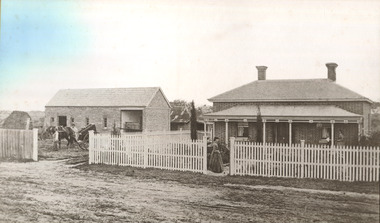
115 Jasper Road, Bentleigh East was a market garden owned by James Allan. In 1880 the property was transferred to David Grewar (Gruar) who had married James' niece Mary Allan. In 1926 part of the land was subdivided and sold as residential blocks. The block with the house pictured remained in the family until 1969. The land now forms part of Our Lady of Sacred Heart College. The description of the land owned by David Kidd Grewer (also spelt Gruar) in 1885: Fourteen acres or thereabouts at the corner of Jasper Road and Patterson’s Road East Brighton being part of Crown Block of 5720 acres Parish of Moorabbin County of Bourke being land comprised in Certificate of Title Volume 1344 Folio 268692 on which is erected a 4 roomed brick house with 2 rooms of wood at the rear and stable and a 2 roomed weatherboard cottage valued as under: 14 acres of land less crops £629.0.0 4 roomed brick house £250.0.0 Other buildings £50.0.0 2 roomed weatherboard cottage £35.0.0 Early pioneer family of the City of Moorabbin.Black and White photo in picture framegrewar, market garden, moorabbin, bentleigh, jasper road, housing, pioneer, james allan, orchard -
 Whitehorse Historical Society Inc.
Artwork, other - Ink Line Drawing, 1 Nives Crt., Burwood.E, 2003
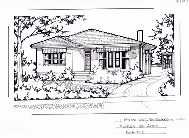
A property illustration by Margaret Picken Commissioned by a real estate agency for the purpose of advertising 1 Nives Crt., Burwood East. This property is listed as having sold for $315,000 in 2003 Made by using Rotring ‘Rapidigraph’ drafting pens with Rotring ink on Rapidigraph polyester drafting film, double matte. Trained as a cartographic draftsman within the mining industry, Margaret Picken is an artist who worked producing property illustrations for real estate agencies in eastern suburbs of Victoria from 1983-2005. Retiring from the industry as technological changes favored coloured photography over illustrations, and commissioning companies over sole contractors.This artwork is of Historical Significance as a record of local domestic architecture.A black ink line drawing on drafters film by Margaret Picken, of 1 Nives Crt., Burwood East A one story brick house with covered porch in the background, and front lawn with a path leading from the driveway on the left to the to the entrance. The driveway leads to a picket back fence and gate.1 Nives Crt., Burwood.E Picken © 2003 Realtorwhitehorse historical society, schwerkolt cottage, housing, architecture, margaret picken, burwood, house, garden, burwood east -
 Whitehorse Historical Society Inc.
Artwork, other - Ink Line Drawing, Margaret Picken, 1 Wandin Crt., Forest Hill, 1990
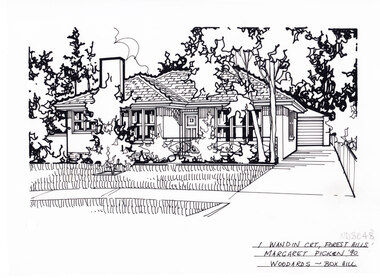
A property illustration by Margaret Picken Commissioned by the real estate agency Woodards Boxhill for the purpose of advertising 1 Wandin Crt., Forest Hill built circa 1950. This property has be listed as having sold for $119,950 in 1991. Made by using Rotring ‘Rapidigraph’ drafting pens with Rotring ink on Rapidigraph polyester drafting film, double matte. Trained as a cartographic draftsman within the mining industry, Margaret Picken is an artist who worked producing property illustrations for real estate agencies in eastern suburbs of Victoria from 1983-2005. Retiring from the industry as technological changes favored coloured photography over illustrations, and commissioning companies over sole contractors.This artwork is of Historical Significance as a record of local domestic architecture.A black ink line drawing on drafters film by Margaret Picken, of 1 Wandin Crt., Forest Hill depicting a brick single story house with chimney set back from a front lawn with shrubs and trees. On the Right is a driveway leading to a separate garage. There are two hole punch holes near the centre of the left edge1 Wandin Crt., Forest Hill Margaret Picken '90 Woodards - BoxHillwhitehorse historical society, schwerkolt cottage, housing, architecture, margaret picken, house, garden, forest hill, real estate -
 Whitehorse Historical Society Inc.
Artwork, other - Ink Line Drawing, Margaret Picken, 4 Yea Crt., Forest Hill, 1994
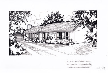
A property illustration by Margaret Picken Commissioned by the real estate agency Woodards Boxhill for the purpose of advertising 4 Yea Crt., Forest Hill. This property has be listed as having sold for $120,000 in 1994. Made by using Rotring ‘Rapidigraph’ drafting pens with Rotring ink on Rapidigraph polyester drafting film, double matte. Trained as a cartographic draftsman within the mining industry, Margaret Picken is an artist who worked producing property illustrations for real estate agencies in eastern suburbs of Victoria from 1983-2005. Retiring from the industry as technological changes favored coloured photography over illustrations, and commissioning companies over sole contractors.This artwork is of Historical Significance as a record of local domestic architecture.A black ink line drawing on drafters film by Margaret Picken, of 4 Yea Crt., Forest Hill depicting a brick single story house, with a driveway on the left leading to separate garage. off of the driveway are two paths, one past the front of the house and one up to the front door. There are two hole punch holes near the centre of the upper edge4 Yea Crt., Forest Hill Margaret Picken '94 Woodards - BoxHillwhitehorse historical society, schwerkolt cottage, housing, architecture, margaret picken, house, garden, forest hill, real estate -
 Whitehorse Historical Society Inc.
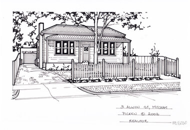
Artwork, other - Ink Line Drawing, Margaret Picken, 3 Alwyn St., Mitcham, 2002
A property illustration by Margaret Picken Commissioned by a real estate agency for the purpose of advertising3 Alwyn St., Mitcham. This property has be listed as having sold for $325,000 in 2002. Made by using Rotring ‘Rapidigraph’ drafting pens with Rotring ink on Rapidigraph polyester drafting film, double matte. Trained as a cartographic draftsman within the mining industry, Margaret Picken is an artist who worked producing property illustrations for real estate agencies in eastern suburbs of Victoria from 1983-2005. Retiring from the industry as technological changes favored coloured photography over illustrations, and commissioning companies over sole contractors.This artwork is of Historical Significance as a record of local domestic architecture.A black ink line drawing on drafters film by Margaret Picken, of 3 Alwyn St., Mitcham depicting a weatherboard cottage with corrugated roof and bullnose verandah, set back from a picket fence and front lawn with gumtree. To the left is a driveway leading to a detached garage There are two hole punch holes near the centre of the upper edge3 Alwyn St., Mitcham Picken © 2002 Realtorwhitehorse historical society, schwerkolt cottage, housing, architecture, margaret picken, house, garden, real estate, mitcham -
 Whitehorse Historical Society Inc.
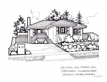
Artwork, other - Ink Line Drawing, Margaret Picken, 63 Vicki St., Forest Hill, 1998
A property illustration by Margaret Picken Commissioned by the real estate agency Hocking Stuart Blackburn for the purpose of advertising 63 Vicki St., Forest Hill This property has be subdivided into two house since being sold in 2002. Made by using Rotring ‘Rapidigraph’ drafting pens with Rotring ink on Rapidigraph polyester drafting film, double matte. Trained as a cartographic draftsman within the mining industry, Margaret Picken is an artist who worked producing property illustrations for real estate agencies in eastern suburbs of Victoria from 1983-2005. Retiring from the industry as technological changes favored coloured photography over illustrations, and commissioning companies over sole contractors.This artwork is of Historical Significance as a record of local domestic architecture.A black ink line drawing on drafters film by Margaret Picken, of 63 Vicki St., Forest Hill depicting a single story brick house with steps up the concealed doorway. On the left a driveway leads to a gated garage, on the right in the foreground is a front garden.63 Vicki St., Forest Hill Margaret Picken © 2002 Hocking Stuart B/Burnwhitehorse historical society, schwerkolt cottage, housing, architecture, margaret picken, house, garden, forest hill, real estate -
 Whitehorse Historical Society Inc.
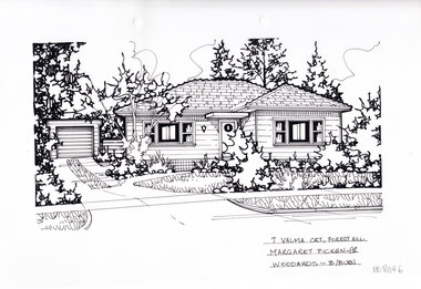
Artwork, other - Ink Line Drawing, Margaret Picken, 7 Valma Crt., Forest Hill, 1998
A property illustration by Margaret Picken Commissioned by a real estate agency for the purpose of advertising 7 Valma Crt., Forest Hill This property is listed as having sold for $160,500 in 1998. Made by using Rotring ‘Rapidigraph’ drafting pens with Rotring ink on Rapidigraph polyester drafting film, double matte. Trained as a cartographic draftsman within the mining industry, Margaret Picken is an artist who worked producing property illustrations for real estate agencies in eastern suburbs of Victoria from 1983-2005. Retiring from the industry as technological changes favored coloured photography over illustrations, and commissioning companies over sole contractors.This artwork is of Historical Significance as a record of local domestic architecture.A black ink line drawing on drafters film by Margaret Picken, of 7 Valma Crt., Forest Hill depicting a single story weatherboard house set back from a front lawn. On the left is a driveway leading to a separate garage There are two hole punch holes near the centre of the upper edge.7 Valma Crt., Forest Hill Margaret Picken -98 Woodards B/Burnwhitehorse historical society, schwerkolt cottage, housing, architecture, margaret picken, house, garden, forest hill, real estate -
 Whitehorse Historical Society Inc.
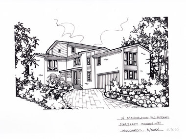
Artwork, other - Ink Line Drawing, Margaret Picken, 14 Manorwood Plc. Mitcham, 1997
A property illustration by Margaret Picken Commissioned by a real estate agency for the purpose of advertising 14 Manorwood Plc. Mitcham. This property is listed as having sold for $240,000 in 1997 Made by using Rotring ‘Rapidigraph’ drafting pens with Rotring ink on Rapidigraph polyester drafting film, double matte. Trained as a cartographic draftsman within the mining industry, Margaret Picken is an artist who worked producing property illustrations for real estate agencies in eastern suburbs of Victoria from 1983-2005. Retiring from the industry as technological changes favored coloured photography over illustrations, and commissioning companies over sole contractors.This artwork is of Historical Significance as a record of local domestic architecture.A black ink line drawing on drafters film by Margaret Picken, of 14 Manorwood Plc. Mitcham depicting a black and white line drawing of a multi level brick house with weatherboard feature at the windows. There is a driveway curving from the righthand side of the foreground up to a built in garage, with garden either side of the driveway. There are two holepunch holes centred just under the upper edge14 Manorwood Plc. Mitcham Margaret Picken -97 Woodards - b/burnwhitehorse historical society, schwerkolt cottage, housing, architecture, margaret picken, house, garden, real estate, mitcham -
 Whitehorse Historical Society Inc.
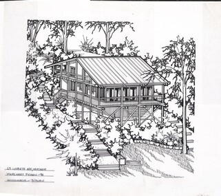
Artwork, other - Ink Line Drawing, Margaret Picken, 63 Lisbeth Ave., Mitcham, 1994
A property illustration by Margaret Picken Commissioned by a real estate agency for the purpose of advertising 63 Lisbeth Ave., Mitcham. This property has be listed as having sold for $325,000 in 2002. Made by using Rotring ‘Rapidigraph’ drafting pens with Rotring ink on Rapidigraph polyester drafting film, double matte. Trained as a cartographic draftsman within the mining industry, Margaret Picken is an artist who worked producing property illustrations for real estate agencies in eastern suburbs of Victoria from 1983-2005. Retiring from the industry as technological changes favored coloured photography over illustrations, and commissioning companies over sole contractors.This artwork is of Historical Significance as a record of local domestic architecture.A black ink line drawing on drafters film by Maragret Picken, of an angled view from above of a elevated bush block, with three story timber stilt house situated into the hill. In the lower right corner is the bottom of the hill, and a front lawn with a edged garden bed behind. While on either side of the house are steps leading up the hill to the back of the block. The house has steps leading up to a partial wrap around verandah There are two hole punch holes along the top edge63 Lisbeth Ave., Mitcham Margaret Picken - 94 Woodards -whitehorse historical society, schwerkolt cottage, housing, architecture, margaret picken, house, garden, real estate, mitcham -
 Whitehorse Historical Society Inc.
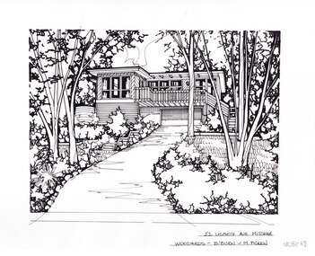
Artwork, other - Ink Line Drawing, Margaret Picken, 52 Lisbeth Ave., Mitcham, circa 1990's-2000's
A property illustration by Margaret Picken Commissioned by a real estate agency for the purpose of advertising 52 Lisbeth Ave., Mitcham Made by using Rotring ‘Rapidigraph’ drafting pens with Rotring ink on Rapidigraph polyester drafting film, double matte. Trained as a cartographic draftsman within the mining industry, Margaret Picken is an artist who worked producing property illustrations for real estate agencies in eastern suburbs of Victoria from 1983-2005. Retiring from the industry as technological changes favored coloured photography over illustrations, and commissioning companies over sole contractors.This artwork is of Historical Significance as a record of local domestic architecture.A black ink line drawing on drafters film by Margaret Picken, of 52 Lisbeth Ave., Mitcham depicting a black and white line drawing of a two story house with built in garage perched at the top of a steep driveway winding up from the centre foreground. There is garden either side, with gumtrees and shrubs. There are two holepunch holes centered just under the upper edge52 Lisbeth Ave., Mitcham Woodards - b/burn - M.Pickenwhitehorse historical society, schwerkolt cottage, housing, architecture, margaret picken, house, garden, real estate, mitcham -
 Whitehorse Historical Society Inc.
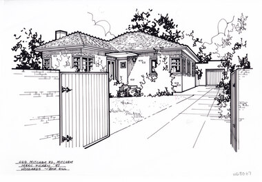
Artwork, other - Ink Line Drawing, Margaret Picken, 444 Mitcham Rd., Mitcham, 1987
A property illustration by Margaret Picken Commissioned by a real estate agency for the purpose of advertising 444 Mitcham Rd., Mitcham. This property is listed as having sold for $78,000 in 1985 Made by using Rotring ‘Rapidigraph’ drafting pens with Rotring ink on Rapidigraph polyester drafting film, double matte. Trained as a cartographic draftsman within the mining industry, Margaret Picken is an artist who worked producing property illustrations for real estate agencies in eastern suburbs of Victoria from 1983-2005. Retiring from the industry as technological changes favored coloured photography over illustrations, and commissioning companies over sole contractors.This artwork is of Historical Significance as a record of local domestic architecture.A black ink line drawing on drafters film by Margaret Picken, of 444 Mitcham Rd., Mitcham depicting a black and white line drawing of a single story brickhouse, viewed from the gated driveway, which leads to a separate garage at the end of the driveway. on the left is a front lawn enclosed by the brick fence. There are two holepunch holes centred just under the upper edge.444 Mitcham Rd., Mitcham Marg. Picken '87 Woodards - boxhillwhitehorse historical society, schwerkolt cottage, housing, architecture, margaret picken, house, garden, real estate, mitcham -
 Whitehorse Historical Society Inc.
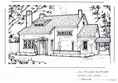
Artwork, other - Ink Line Drawing, Margaret Picken, 411 Mitcham Rd., Mitcham, 2003
A property illustration by Margaret Picken Commissioned by a real estate agency for the purpose of advertising 411 Mitcham Rd., Mitcham. This property is listed as having sold for $695,000 in 2003 Made by using Rotring ‘Rapidigraph’ drafting pens with Rotring ink on Rapidigraph polyester drafting film, double matte. Trained as a cartographic draftsman within the mining industry, Margaret Picken is an artist who worked producing property illustrations for real estate agencies in eastern suburbs of Victoria from 1983-2005. Retiring from the industry as technological changes favored coloured photography over illustrations, and commissioning companies over sole contractors.This artwork is of Historical Significance as a record of local domestic architecture.A black ink line drawing on drafters film by Margaret Picken, of 14 Manorwood Plc. Mitcham depicting a black and white line drawing of a two story brick house with connected carport and separate garage at the end of the driveway on the right. There are trees and small hedging across the front of the house.14 Manorwood Plc. Mitcham Margaret Picken -97 Woodards - b/burnwhitehorse historical society, schwerkolt cottage, housing, architecture, margaret picken, house, garden, real estate, mitcham -
 Whitehorse Historical Society Inc.
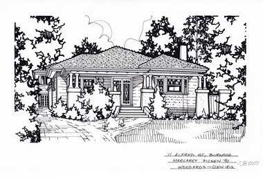
Artwork, other - Ink Line Drawing, 11 Alfred St., Burwood, 1999
A property illustration by Margaret Picken Commissioned by the real estate agency Woodards, Camberwell for the purpose of advertising 11 Alfred St., Burwood for sale in 1990. Made by using Rotring ‘Rapidigraph’ drafting pens with Rotring ink on Rapidigraph polyester drafting film, double matte. The suburb lines are believed to have been redrawn, making this property no longer in Burwood, but located in Glen iris. This property is listed as having sold for in 1990, Trained as a cartographic draftsman within the mining industry, Margaret Picken is an artist who worked producing property illustrations for real estate agencies in eastern suburbs of Victoria from 1983-2005. Retiring from the industry as technological changes favoured coloured photography over illustrations, and commissioning companies over sole contractors.This artwork is of Historical Significance as a record of local domestic architecture.A black ink line drawing on drafters film by Maragret Picken, of 11 Alfred St., Burwood. Depicted is a one-story weatherboard situated back from a front lawn with a large tree, and a brick driveway on the left. Bushes are planted in front of the porch, and greenery on the left and right of the image. There to two hole punches just below the upper edge. 11 Alfred St., Burwood Maragret Picken -'99 Woodards - Glen Iriswhitehorse historical society, schwerkolt cottage, housing, architecture, margaret picken, burwood, glen iris, house, garden