Showing 2286 items matching " parish."
-
 Bendigo Historical Society Inc.
Map - COSTERFIELD, 2/09/1939
Map: Costerfield, Counties of Dalhousie and Rodney. Parish plan ( number 163 in Map Cupboard 1)map, dalhousie, parish plan, costerfield, counties of dalhousie and rodney -
Bendigo Historical Society Inc.
Map - ELMORE, 7/08/1911
Map: Township of Elmore, Parish of Elmore, County of Bendigo ( number 159 in Map Cupboard 1)map, bendigo, township, elmore, county of bendigo -
Bendigo Historical Society Inc.
Map - GOORNONG, 1/10/1906
Map: Township of Goornong, Parish of Goornong, County of Bendigo ( number 154 in Map Cupboard 1)map, bendigo, township, goornong, county of bendigo -
Bendigo Historical Society Inc.
Map - GOORNONG, Revised 5/06/1926
Map: Town of Goornong, Parish of Goornong, County of Bendigo ( number 153 in Map Cupboard 1)map, bendigo, township, goornong, county of bendigo -
Bendigo Historical Society Inc.
Map - HUNTLY, 7/01/1904
Map: Township of Huntly, Parish of Huntly, County of Bendigo ( number 150 in Map Cupboard 1)map, bendigo, township, huntly, parish of huntly, county of bendigo -
Bendigo Historical Society Inc.
Map - HARCOURT, 2/04/1917
Map: Town of Harcourt, County of Talbot. Parish plan (number 264 in map cupboard 1)map, talbot, township, harcourt -
Bendigo Historical Society Inc.
Map - TOWNSHIP OF HEATHCOTE SHEET 2, Circa 1935
Map: Township of Heathcote sheet 2. Parish plan (number 254 in map cupboard 1)map, dalhousie, township, heathcote -
Bendigo Historical Society Inc.
Map - TARNAGULLA, Examined May 1883
Map: Tarnagulla, Counties of Gladstone and bendigo. Parish plan ( number 244 in Map Cupboard 1)map, gladstone, parish plan, tarnagulla, gladstone -
Bendigo Historical Society Inc.
Map - EPPALOCK RESURVEY, Circa 1880
Map: Eppalock resurvey, hand draughted parish plan ( number 239 in Map Cupboard 1)map, bendigo, parish plan, eppalock -
Bendigo Historical Society Inc.
Map - CITY OF SANDHURST SHEET NO 4, 25/04/1882
Map: City of sandhurst sheet No. 4. Parish plan ( number 224 in Map Cupboard 1)map, bendigo, parish plan, sandhusrt -
Bendigo Historical Society Inc.
Map - CITY OF SANDHURST SHEET NO. 5, 18/04/1882
Map: City of sandhurst sheet No. 5. Parish plan ( number 223 in Map Cupboard 1)map, bendigo, parish plan, sandhusrt -
Bendigo Historical Society Inc.
Map - CITY OF BENDIGO SHEET NO. 4, Circa 1900
Map: City of Bendigo sheet No. 4. Parish plan ( number 218 in Map Cupboard 1)map, bendigo, parish plan, bendigo -
Bendigo Historical Society Inc.
Map - CITY OF BENDIGO SHEET NO. 2, Circa 1900
Map: City of Bendigo sheet No. 2 . Parish plan ( number 217 in Map Cupboard 1)map, bendigo, parish plan, bendigo -
Bendigo Historical Society Inc.
Map - CITY OF BENDIGO SHEET NO. 6, surveyed 3/03/1882
Map: City of Bendigo sheet No. 6 . Parish plan ( number 215 in Map Cupboard 1)map, bendigo, parish plan, bendigo -
Bendigo Historical Society Inc.
Map - CITY OF BENDIGO SHEET NO. 5, Circa 1890's
Map: City of Bendigo sheet No. 5. Parish plan ( number 213 in Map Cupboard 1)map, bendigo, parish plan, bendigo -
Bendigo Historical Society Inc.
Map - SALISBURY WEST, 29/01/1878
Map: Salisbury West, County of Gladstone. Parish plan (number 305 in map cupboard 1)map, gladstone, parish plan, salisbury west -
Bendigo Historical Society Inc.
Map - JANIEMBER EAST, No date visible
Map: Janiember East, Hand Draughted? Parish plan (number 299 in map cupboard 1)map, bendigo, parish plan, janiember east , serpentine -
Bendigo Historical Society Inc.
Map - AXEDALE, 10/10/1904
Map: Axedale, Counties of Bendigo and Rodney. Parish plan (number 297 in map cupboard 1)map, bendigo, parish plan, axedale -
Bendigo Historical Society Inc.
Map - MANDURANG 2, March 194-?
Map: Mandurang 2, County of Bendigo. Parish plan (number 296 in map cupboard 1)map, bendigo, parish plan, mandurang -
Bendigo Historical Society Inc.
Map - MANDURANG 1, March 1947
Map: Mandurang 1, County of Bendigo. Parish plan (number 295 in map cupboard 1)map, bendigo, parish plan, mandurang -
Bendigo Historical Society Inc.
Map - HUNTLY ALLOTMENTS, No date visible
Map; Huntly Allotments, County of Bendigo. Parish plan (number 289 in map cupboard 1)map, bendigo, allotments, huntly allotments -
Bendigo Historical Society Inc.
Map - ROCHESTER WEST, 22/12/1881
Map: Rochester West, County of Bendigo. Parish plan (number 279 in map cupboard 1)map, bendigo, parish plan, rochester west -
Bendigo Historical Society Inc.
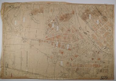
Map - COUNTY OF BENDIGO, No date visible
Map. Plan showing all of the Parishes in the County of Bendigo (number 342 in map cupboard 1)map, bendigo, parishes, county of bendigo -
Stawell Historical Society Inc
Map, T.F. McGauran, William Couty of Borong 1891, 1891
Stawell Water Supply Reserve. Grampians State Forest. Dairy Creek, Fyans Creek, Barney's Creek, Bovine Creek, Glasstree Creek, Stoney Creek. Stawell Water Supply Aquaduct Fkuming Tunnel.A2 Parish Map of Willam Inculdin Stawell Water Supply Reserve and Creeks. Marked in redPhoto Lithographed at the Department of Lands and Survey Melbourne. By T.F. McGauran 20.07.91 water supply survey -
Whitehorse Historical Society Inc.
Document, Sale Plan 38, 12/09/1855
Parish of Nunawading Sale Plan 38.Parish of Nunawading Sale Plan 38. Description of land is given with water supply. Surveyor C.Hodgkinson.Parish of Nunawading Sale Plan 38. parish of nunawading, hodgkinson, clement, water supply -
Whitehorse Historical Society Inc.
Newspaper - Article, Blood's Cottage, Box Hill, 2/12/1992
Blood's Cottage [ the oldest surviving house in the Parish of Nunawading] recently used by Oxford Childrens Theatre.bloods cottage, box hill, blood, robert, oxford childrens theatre, mudge, joy, port, ian -
 Rutherglen Historical Society
Photograph - Image, 1940-1949 (Approximate)
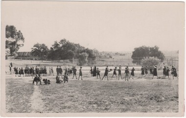
Donated by the Presentation Sisters of Mt Carmel Convent Rutherglen. Convent closed May 1990Black & white snapshot of pupils of St Mary's Parish School playing ball games (unmounted)"Playground St Mary's School - Rutherglen"st marys school, school sports, school games, playground -
 Lions Club of Maldon Inc.
Photographs, Tennis Ladies
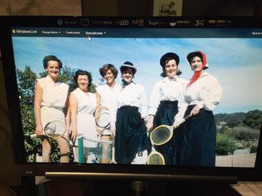
Image of six ladies with tennis raquets. Contains Ethel Parish, Joan Penny and Dot Johnson -
 Bendigo Historical Society Inc.
Map - CITY OF SANDHURST RESURVEY SHEET 1, 21/05/1881
Map: City of Sandhurst resurvey sheet 1. Parish plan showing the Southeastern corner of the Municipalitymap, bendigo, parish plan, sandhurst, resurvey -
 Ringwood and District Historical Society
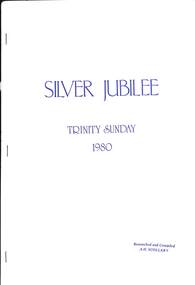
Book, Silver Jubilee - Trinity Sunday 1980, 1980
History of Holy Trinity Church, Patterson Street,. Ringwood East - 25th Anniversary 1955-1980, researched and compiled by A.H. ScollaryForeword by The Rev. Dr. George A. Mullins, first vicar of The Parish of Holy Trinity Ringwood East