Showing 7614 items matching " road development"
-
 Greensborough Historical Society
Photograph - Digital image, Marilyn Smith et al, Janefield Precinct: Looking towards the future - new residential development, 27/11/2014
Janefield Precinct: Looking towards the future - new residential development. The remains of this site are between Greensborough and Janefield. A RAAF Hygiene Training Camp was located on the Plenty River, just south of the Janefield community. It was in use from 1944 to 1946. The Camp was constructed from salvaged materials. Instruction included building and maintenance of grease traps, latrines, elementary plumbing and carpentry.Early remains of a WW2 training camp Digital colour photograph.janefield -
 Greensborough Historical Society
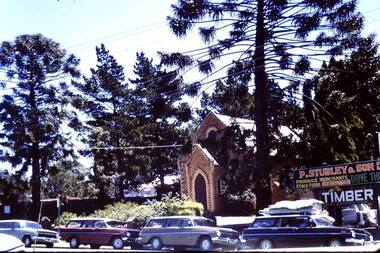
Photograph - Digital image, Methodist Church and Stubleys Main Street, Greensborough, 1970c
The old Methodist Church in Main Street Greensborough was demolished in the 1970s for the development of Greensborough Plaza. The Church was sited near the present entrance to the Plaza.Digital copy of colour photograph.methodist church greensborough, main street greensborough -
 Greensborough Historical Society
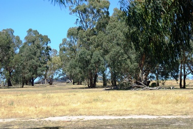
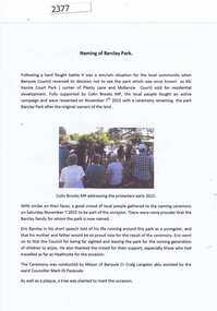
Report and photographs, Barclay Park Greensborough, 07/11/2015
On November 7, 2015 a small park in Greensborough (previously known as McKenzie Court Park, corner Plenty Lane and McKenzie Court) was renamed as Barclay Park after a local family. henry and Dorothy Barclay farmed Grace Park from 1938. Members of the family were present at the ceremony conducted by Banyule Mayor Craig Langdon assisted by Ward Councillor Mark di Pasquale. This open ground was saved from development through the work of local residents.Collection of 6 photographs and a report.barclay family, eric barclay, craig langdon, barclay park -
 Greensborough Historical Society
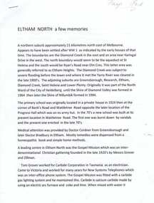
Article, Eltham North history, 1945o
A short history of the development of Eltham North including information on some of the early families in the area.Typed article of 4 pages. eltham north -
 Greensborough Historical Society
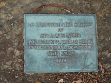
Photograph - Digital image, Dennis Ward, Plaque - A. H. W. Webb, 27/03/2010
Plaque on Plenty River Trail at Greensborough: "To perpetuate the memory of Mr A. H. W. Webb for services over 25 years in founding and developing this park".Sign from the early development days of the Plenty River Trail.Digital copy of colour photographs.plenty river trail, a h w webb -
 Greensborough Historical Society
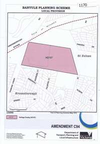
Map, Saxam Heritage Overlay, 2011_
"Saxam" was the home of the Kaye family (1886-1888) then William Santon, a former councillor and Mayor of Heidelberg. Saxam Homestead is a distinctive and substantial timber homestead built in the late 1880s as one of the notable rural properties in the St Helena area. In 2014 the house still stands but is in poor condition with most interior features removed. The site had a heritage overlay as shown. The overlay was reduced in 2014 to protect the house while allowing residential development on the site.Saxam is one of the only remaining farmhouses in the Greensborough area.Copy of map and planning scheme.saxam -
 Greensborough Historical Society
Article, Norm Colvin et al, John Cecil Jessop: a community minded individual, 29/03/1892o
Cecil Jessop was an important figure in the development of Greensborough. This outline of his life by Norm Colvin discusses his work as a councillor, MMBW, and Sutherland Homes. Additional material on his War Service by John Gibson with photographs from the collection of Jean Luxford.A brief outline of an important Greensborough identity.7 pages, text and photographs.jessop family, cecil jessop, councillors, mmbw, yan yean reservoir, greensborough -
 Greensborough Historical Society
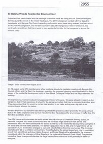
Article, Greenhills Progress Association, St Helena Woods Residential Development, 19/08/2015
Concerns by the Greenhills Progress Association and residents about the St Helena Woods residential development by Far East.One page, text and photograph st helena woods, greenhills progress associatiion -
![Document, Town Planning Appeals Tribunal, Town Planning Appeals Tribunal report 1978 [Loyola College], 06/11/1978](/media/collectors/4f729f5697f83e03086015b8/items/58bbb237d0cdef1bcc864955/item-media/58bbb35fd0cdef1bcc8683be/item-fit-380x285.jpg) Greensborough Historical Society
Greensborough Historical SocietyDocument, Town Planning Appeals Tribunal, Town Planning Appeals Tribunal report 1978 [Loyola College], 06/11/1978
Report on an appeal against two conditions on the development of land in Grimshaw Street Watsonia for a secondary school [Loyola College].This document demonstrates some of the problems associated with setting up a school in a residential area.3 pages, torn and yellowed.loyola college -
 Greensborough Historical Society
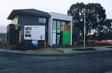
Photograph - Digital image, Frank Solomon, First dwelling in the One Evelyn Way development, 2010c
First home built on the One Evelyn Way development in Greensborough This site was previously a pig farm and there were some environmental concerns as this site was developed.Digital copy of colour photographone evelyn way greensborough -
 Greensborough Historical Society
Plan, Plan of Manatunga Circuit Greensborough subdivision, 1970_
Plan of Manatunga Circuit subdivision. Prepared by O'Connor and Beveridge (land surveyors) for Development Underwriting (developers). Plan of subdivision. Part of Crown Portion 3. Parish of Nillumbik, County of Evelyn.An original example of a subdivision plan in the expanding suburb of Greensborough. The 1960s and 1970s saw this area develop from a rural farming area to a suburb.Plan of subdivision. Printed on buff paper, hand coloured. Mounted on cardboard. Includes 2 small cards attached.Various handwritten comments. Small cards from Survey Branch, Office of Titles.greensborough, manatunga circuit, diamond creek road, plenty river drive -
![Correspondence, Shire of Diamond Valley, Greensborough District Centre [Letter], 06/01/1989](/media/collectors/4f729f5697f83e03086015b8/items/520c24bc2162ef085803edef/item-media/58ad17ced0ce3d14e8edcc01/item-fit-380x285.jpg) Greensborough Historical Society
Greensborough Historical SocietyCorrespondence, Shire of Diamond Valley, Greensborough District Centre [Letter], 06/01/1989
The letter was sent to the Fraser Family in response to a query on the future of the Greensborough District Centre.At the time of its creation Greensborough was undergoing a lot of change and there was a fear among older residents that the character of the town would be lost.A 5 page letter on the letterhead of the former Shire of Diamond Valley. Nilgreensborough district centre, shire of diamond valley, fraser family, development, 1989 -
 Greensborough Historical Society
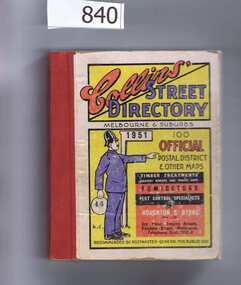
Book, Collins' Street Directory: Melbourne & suburbs 1951, 1951_
This 1951 street directory covers many Melbourne suburbs but not Greensborough. In the 1950s Greensborough was still a rural settlement. This directory is interesting for anyone wanting to check mid-20th century developments.A comprehensive coverage of suburban, inner city streets.Street directory. 411 pages, maps.melbourne, street directories -
 Greensborough Historical Society
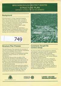
Pamphlet, Shire of Diamond Valley, Greensborough District Centre, Structure Plan, 1988_
This was issued in 1988 calling for comments regarding the proposed development of the Greensborough Centre in 1988.This pamphlet has pictures of Greensborough as it was in 1988 and 4 concept plans for the proposed development.A 6 page folded pamphlet with green print on a glossy yellow paper.Nilgreensborough centre, 1988, diamond valley shire, lend lease -
 Greensborough Historical Society
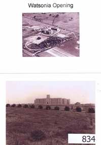
Photographs, Watsonia opening; Loyola seminary. Circa 1934, 01/08/1934
The Society of Jesus (Jesuits) opened the seminary in 1934. These photographs were part of the advertising for the opening ceremony. The Jesuit Order had a presence on the site from 1934 to 1974 where a house of formation and studies for the Society of Jesus was located (the current Old Loyola building purchased by the College in 2002). Loyola College Watsonia now occupies the site.1934 photographs showing the site before the residential development in the area.Four photographs and one photocopy. Aerial and ground views.loyola college, jesuits, loyola seminary -
 Greensborough Historical Society
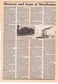
Newspaper clipping, Victorian Baptist Witness, Memory and hope at Strathalan, 1995_03
Review and extracts from "Memory and Hope", an 87 page history of Strathalan Baptist Home for the aged, by Damian X. Powell, from purchase in 1906/7 of the Strathalan homestead and 15 acres of land in Macleod by the Victorian Baptist Union to 1958 when further development of the site was halted.1 page, text and black and white images.strathalan baptist home for the aged, macleod -
 Greensborough Historical Society
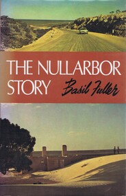
Book, Basil Fuller, The Nullarbor story, by Basil Fuller, 1970_
The history of development of the Nullarbor and the author's personal journey across this area of Australia. Hardback, 165 p., black and white photographs, col. dust jacket."C. G. Aitken"south australia, nullarbor -
 Greensborough Historical Society
Newspaper Clipping, Diamond Valley Leader, Drive to save course, 22/03/2017
A campaign to save Strathallan Golf Course is gaining steam with a petition against development garnering more than 1000 signatures.News article 1 page, black text, colour image.strathallan golf club, campaign to save, petition -
 Greensborough Historical Society
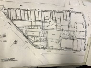
Planning Document, Banyule City Council, Site plan of Greensborough 1997, 28/07/1997
Site plans for the area bounded by Flintoff Street; Grimshaw Street; Main Street and Para Road Greensborough. these plans show the area before the development of Watermarc.This plan shows central Greensborough before the Watermarc developmentSet of 8 site plansgreensborough, greensborough swimming pool -
 Greensborough Historical Society
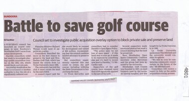
Newspaper Clipping, Diamond Valley Leader, Battle to save golf course, 05/07/2017
A suburban council has launched an urgent campaign to save Bundoora's Strathallan Golf Course from urban development.News article 1 page, black text.strathallan golf club, darebin council, bundoora -
 Greensborough Historical Society
Newspaper Clipping, Diamond Valley Leader, Vision for golf site, 02/08/2017
La Trobe University has broken its silence over the future of Strathallan Golf Course, revealing a vision for the land that includes residential development, sports facilities and bike trails.News article 1 page, black text.strathallan golf club, la trobe university, darebin council, bundoora -
 Greensborough Historical Society
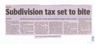
Newspaper Clipping, Subdivision tax set to bite, 13/09/2017
Mum and dad developers face being slugged with an extra tax to subdivide their properties.News article 1 page, black text.tax, subdivision plans, land development, banyule city council -
 Greensborough Historical Society
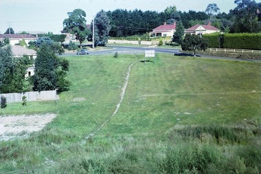
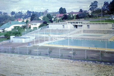
Photograph - Digital Image, Geoffrey Vanner, Greensborough Pool site, 1962c
The site for Greensborough Swimming Pool prior to development. The Pool opened in 1964.Digital copy of colour photograph. greensborough swimming pool -
 Greensborough Historical Society
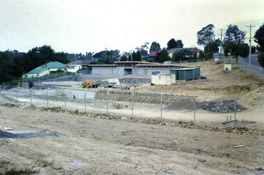
Photograph - Digital Image, Geoffrey Vanner, Greensborough Pool development 1964, 1963_
The site for Greensborough Swimming Pool during development. The Pool opened in 1964.Digital copy of colour photograph. greensborough swimming pool -
 Greensborough Historical Society
Photograph - Digital Image, Geoffrey Vanner, Greensborough Pool development 1963, 1963_
The site for Greensborough Swimming Pool during development. In these photos the pool buildings have been constructed. The Pool opened in 1964.Digital copy of colour photograph. greensborough swimming pool -
 Greensborough Historical Society
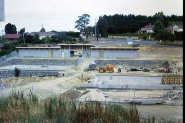
Photograph - Digital Image, Geoffrey Vanner, Greensborough Pool development 1964, 1964_
The site for Greensborough Swimming Pool during development. In these photos the pools have been filled. The Pool opened in 1964.Digital copy of colour photograph. greensborough swimming pool -
 Greensborough Historical Society
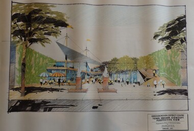
Planning Document, Shire of Diamond Valley, Greensborough District Centre, Town Square Concept Plans 1991, 1991_02
Plans and concept drawings for the proposed development of the Greensborough District Centre, Town Square. Shire of Diamond Valley existed from 1964 to 1994.7 plans and 2 concept drawings, black and coloured ink on white paper.shire of diamond valley, greensborough -
 Greensborough Historical Society
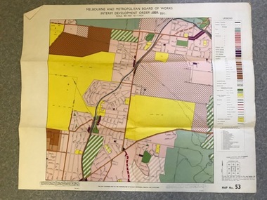
Map, Melbourne and Metropolitan Board of Works Interim Development Order 1961 Map No. 53, 27/09/1961
Denotes Zones and Reservations comprising part of the municipalities of Eltham, Heidelberg, Preston and Whittlesea, approved 27.9.61. Includes Mont Park Hospital and Watsonia Military Camp.Colour plan Date printed on plan (1959) has been over stamped with 1961. Also stamped with Government Gazette date of 27.9.1961. "Scale 800 feet to 1 inch"greensborough, watsonia -
 Greensborough Historical Society
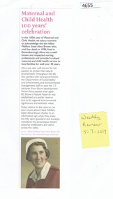
Newspaper Clipping, The Weekly Review, Maternal and child health 100 years' celebration, 05/07/2017
Biographical notes on Infant Welfare Sister Alma Brown, who lived and worked in Greensborough. She was also passionate about protecting the natural environment. After her death, her property was established as Brown's Nature Reserve to stop development of the area.News article, black and red print, sepia photographalma brown, browns nature reserve greensborough -
 Greensborough Historical Society
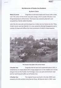
Article, Norm Colvin, My memories of Poulter Ave residents, by Norm Colvin, 28/07/2016
Details of the development and occupation of sites in Poulter Avenue and Bicton Street Greensborough, compiled by resident Norm Colvin.12 pages, text, black and white photographs and colour subdivision plan.poulter avenue greensborough, bicton street greensborough