Showing 2417 items matching "1857-1858"
-
 Phillip Island and District Historical Society Inc.
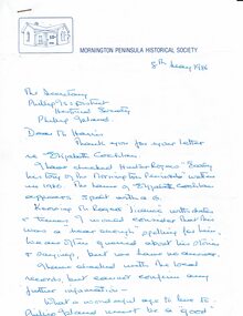
Letter, Eliza Cochlan, information on spelling of her name, 1986
The spelling of Eliza's surname varies between Coghlan and Cochlan in various sources.The letter does not provide proof of either. List of applicants for land at Schnapper Point [Mornington, including Phillip Island], early settlers and their date of arrival. An extract from "Early History of Mornington" showing residents of Schnapper Point in 1858.HistoricalHand written letter from the secretary of the Mornington Peninsula Historical Society re the spelling of Eliza Cochlan's name . Dated 8/5/1986 Also 3 typed pages containing a list of applicants for Phillip Island land grants and extract from The Early history of Mornington.Letter addressed to Mr Harris, secretary PIDHSeliza cochlan, land grant, early phillip island settlers, land ballot -
 Greensborough Historical Society
Photograph - Digital image, Prudence Partington, 1875c
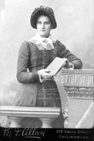
Prudence Partington was born in 1858 at a cottage at the Watsonia Toll Gate operated by her father Charles. The family later moved to Willis Vale. After their parents’ deaths, Maria and Prudence moved to a house in Sellars Street Watsonia in 1890. They lived together until their deaths in 1930, just two months apart.A pioneer Greensborough family.Digital copy of black and white studio photograph.prudence partington, partington family -
 Greensborough Historical Society
Photograph - Digital Image, Prudence Partington, 1883c
Prudence Partington was born in 1858 at a cottage at the Watsonia Toll Gate operated by her father Charles. The family later moved to Willis Vale. After their parents’ deaths, Maria and Prudence moved to a house in Sellars Street Watsonia in 1890. They lived together until their deaths in 1930, just two months apart.A pioneer Greensborough family.Digital copy of black and white studio photograph.prudence partington, partington family -
 Greensborough Historical Society
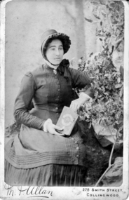
Photograph - Digital Image, Prudence Partington, 1888c
Prudence Partington was born in 1858 at a cottage at the Watsonia Toll Gate operated by her father Charles. The family later moved to Willis Vale. After their parents’ deaths, Maria and Prudence moved to a house in Sellars Street Watsonia in 1890. They lived together until their deaths in 1930, just two months apart.A pioneer Greensborough family.Digital copy of black and white studio photograph.prudence partington, partington family -
 Greensborough Historical Society
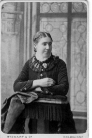
Photograph - Digital image, Prudence Partington, 1900c
Prudence Partington was born in 1858 at a cottage at the Watsonia Toll Gate operated by her father Charles. The family later moved to Willis Vale. After their parents’ deaths, Maria and Prudence moved to a house in Sellars Street Watsonia in 1890. They lived together until their deaths in 1930, just two months apart.A pioneer Greensborough family.Digital copy of black and white studio photograph.prudence partington, partington family -
 Hume City Civic Collection
Photograph, late 1990s
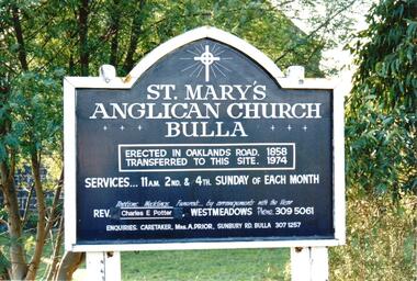
St. Mary's Anglican Church at Bulla was originally built on the outskirts of Bulla township in 1858. In the early 1970s it was moved to its present site to make way for the flight path at the newly constructed Tullamarine Airport. The former site was on the corner of Oaklands and Sunbury Roads and is covered with vegetation. The church was designed by Thomas Taylor.A coloured photograph of the board which is along the fence line outside St. Mary's Church at Bulla. The white writing is on a navy blue background and is framed in white. The notice gives details of services, clergy and caretaker.churches, religion, anglican church, taylor, thomas, potter, charles e. rev., prior, a., st. mary's anglican church, george evans collection -
 Hume City Civic Collection
Photograph, late 1990s
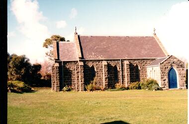
St. Mary's Anglican Church at Bulla was originally built on the outskirts of Bulla township in 1858. In the early 1970s it was moved to its present site to make way for the flight path at the newly constructed Tullamarine Airport. The former site was on the corner of Oaklands and Sunbury Roads and is covered with vegetation. The church was designed by Thomas Taylor.A profile view of the west side of St. Mary's Anglican Church at Bulla and the garden area around the church. A slate covered gable roof has been constructed over the porch nave and chancery with a cross at each end of the roof over the nave. 6 bluestone buttresses and 3 lance windows are along the side with 3 small lancet windows and a blue painted wooden lancet door on the porch.churches, religion, taylor, thomas, st. mary's anglican church, george evans collection -
 Linton and District Historical Society Inc
Photograph, William and Elizabeth Todd and Family, circa 1906
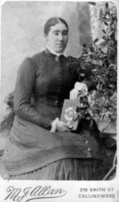
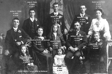
Elizabeth Bennett (b. 1858), married William Todd (b. 1855) in 1882 and they had nine children. They were actively involved in the Linton community, particularly with the Church of England, where Mrs. Todd was organist for many years. They celebrated their Golden Wedding at Linton in 1932, by which time they were living in Ballarat.Scanned/modified copy of a photograph of the Todd family, believed to have been taken in Ballarat around 1905/1906. Members of the family are identified by names and dates, which have been printed across the photo.todd family, elizabeth todd, elizabeth bennett, william todd snr., arthur (paddy) todd, john (jack) todd, william j. (billy) todd, milton todd, susie (lucy agnes) todd, charles (charlie) todd, violet todd, millicent todd, stella todd -
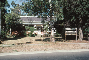 Eltham District Historical Society Inc
Slide - Photograph, Wingrove Cottage, Main Road, Eltham, c.Mar. 1989
"Wingrove Cottage" was built 1858/59 for Charles Symons Wingrove, long serving Secretary and Engineer to the Eltham District Road Board and Shire Council. Sitauted on Main Road Eltha, it is on the Victorian Heritage Database and considered locally significant. In 1989 when this photo was taken the building was being used as a community clinic.See Victorian Heritage Database citation https://vhd.heritagecouncil.vic.gov.au/places/6357435mm colour positive transparency (1 of 28) Mount - Kodak KodachromeProcess Date MAR 89Meltham, main road, wingrove cottage, wingrove cottage community clinic -
 Greensborough Historical Society
Photograph, Prudence Partington, 1888c
Prudence Partington was born in 1858 at a cottage at the Watsonia Toll Gate operated by her father Charles. The family later moved to Willis Vale. After their parents’ deaths, Maria and Prudence moved to a house in Sellars Street Watsonia in 1890. They lived together until their deaths in 1930, just two months apart.A pioneer Greensborough family.Sepia studio photograph of woman.prudence partington, portrait photographs, partington famiy -
 Eltham District Historical Society Inc
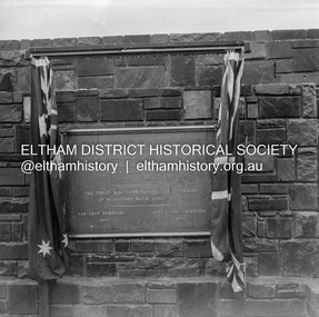
Negative - Photograph, J.A. McDonald, Upper Yarra Dam, 26 Nov. 1957
Upper Yarra Reservoir Opened by His Excellency The Governor of Victoria General Sir Dallas Brooks K.C.B.., K.C.M.G., K.C.V.O., D.S.O., K.St.J. On 26th November, 1957 This tablet also commemortyaes the centenary Of Melbourne's water supply system Yan Yean Reservoir 1857 Upper Yarra Reservoir 1957Record of various Shire of Eltham infrastructure works undertaken during the period of 1952-1962 involving bridge and road reconstruction projects, sometimes with Eltham Shire Council Project Reference numbers quoted. It was during this period that a number of significant improvements were made to roads and new bridges constructed within the shire that remain in place as of present day (2022). In many situations, the photos provide a tangible visible record of infrastructure that existed throughout the early days of the Shire. The album was put together by or under the direction of the Shire Engineer, J.A. McDonald.infrastructure, shire of eltham, 1957-11-26, opening ceremony, plaques, sir dallas brooks, upper yarra dam, upper yarra reservoir -
 Eltham District Historical Society Inc
Negative - Photograph, J.A. McDonald, Upper Yarra Dam, 26 Nov. 1957
Upper Yarra Reservoir Opened by His Excellency The Governor of Victoria General Sir Dallas Brooks K.C.B.., K.C.M.G., K.C.V.O., D.S.O., K.St.J. On 26th November, 1957 This tablet also commemortyaes the centenary Of Melbourne's water supply system Yan Yean Reservoir 1857 Upper Yarra Reservoir 1957Record of various Shire of Eltham infrastructure works undertaken during the period of 1952-1962 involving bridge and road reconstruction projects, sometimes with Eltham Shire Council Project Reference numbers quoted. It was during this period that a number of significant improvements were made to roads and new bridges constructed within the shire that remain in place as of present day (2022). In many situations, the photos provide a tangible visible record of infrastructure that existed throughout the early days of the Shire. The album was put together by or under the direction of the Shire Engineer, J.A. McDonald.infrastructure, shire of eltham, 1957-11-26, opening ceremony, plaques, upper yarra dam, upper yarra reservoir -
 Greensborough Historical Society
Photograph - Digital image, Ruston family, 1865c
Peter Ruston and Martha Roberts had seven children, there are five in this photograph. Anne (1857-83), Martha (1860-1883) between Peter's knees, Sarah (1863-1945), Rachel (1865-1883), Sarah (1865-1957), Mary (1868-1869), Peter (1873-1924) and William (1874-1973).A pioneer Greensborough family.Digital copy of black and white photograph.peter rustin, peter ruston, martha roberts -
 St Kilda Historical Society
Photograph - Photo map, 28/01/1951
One of a series of photo-maps produced for the Department of Crown Lands and Survey (1857-1983). For correlation with a current map, and access to other historical photo maps of Victoria, see the Historic Photo-Maps Index published by the Department of Environment, Land, Water and Planning at https://services.land.vic.gov.au/DELWPmaps/historical-photomaps/Black and white aerial photograph1424-45 SECRET 534 Run 18 Lens 12" Melbourne Metropolitan 12150 28.1.51 M639albert park, st kilda junction, st kilda pier, catani gardens, st kilda, prahran, albert park lake, 1951, middle park, st kilda beach, windsor -
 St Kilda Historical Society
Photograph - Photo map, 17/01/1951
One of a series of photo-maps produced for the Department of Crown Lands and Survey (1857-1983). For correlation with a current map, and access to other historical photo maps of Victoria, see the Historic Photo-Maps Index published by the Department of Environment, Land, Water and Planning at https://services.land.vic.gov.au/DELWPmaps/historical-photomaps/Black and white aerial photograph1414-21 538 Run 19 Lens 12" Melbourne Metropolitan 12150 17.1.51 M586st kilda, st kilda botanical gardens, peanut farm, elwood, 1951, point ormond, elwood canal, st kilda beach -
 St Kilda Historical Society
Photograph - Photo map, 28/01/1951
One of a series of photo-maps produced for the Department of Crown Lands and Survey (1857-1983). For correlation with a current map, and access to other historical photo maps of Victoria, see the Historic Photo-Maps Index published by the Department of Environment, Land, Water and Planning at https://services.land.vic.gov.au/DELWPmaps/historical-photomaps/Black and white aerial photograph1424-118 534 Run 20 Lens 12" Melbourne Metropolitan 12150 18.1.51M639elwood, point ormond, elwood park, elsternwick park, elwood beach, 1951 -
 St Kilda Historical Society
Photograph - Photo map, 17/01/1951
One of a series of photo-maps produced for the Department of Crown Lands and Survey (1857-1983). For correlation with a current map, and access to other historical photo maps of Victoria, see the Historic Photo-Maps Index published by the Department of Environment, Land, Water and Planning at https://services.land.vic.gov.au/DELWPmaps/historical-photomaps/Black and white aerial photograph1414-20 538 Run 19 Lens 12" Melbourne Metropolitan 12150 17.1.51 M586elwood, elsternwick, st kilda east, balaclava, ripponlea, 1951 -
 St Kilda Historical Society
Photograph - Photo map, 28/01/1951
One of a series of photo-maps produced for the Department of Crown Lands and Survey (1857-1983). For correlation with a current map, and access to other historical photo maps of Victoria, see the Historic Photo-Maps Index published by the Department of Environment, Land, Water and Planning at https://services.land.vic.gov.au/DELWPmaps/historical-photomaps/Black and white aerial photograph1424-44 534 Run 18 Lens 12" Melbourne Metropolitan 12150 28.1.51 M639 -
 St Kilda Historical Society
Photograph - Photo map, 28/01/1951
One of a series of photo-maps produced for the Department of Crown Lands and Survey (1857-1983). For correlation with a current map, and access to other historical photo maps of Victoria, see the Historic Photo-Maps Index published by the Department of Environment, Land, Water and Planning at https://services.land.vic.gov.au/DELWPmaps/historical-photomaps/Black and white aerial photograph1424-43 534 Run 18 Lens 12" Melbourne Metropolitan 12150 28.1.51 M639armadale, malvern, st kilda cemetery, caulfield north, st kilda east, 1951 -
 St Kilda Historical Society
Photograph - Photo map, 30/01/1960
One of a series of photo-maps produced for the Department of Crown Lands and Survey (1857-1983). For correlation with a current map, and access to other historical photo maps of Victoria, see the Historic Photo-Maps Index published by the Department of Environment, Land, Water and Planning at https://services.land.vic.gov.au/DELWPmaps/historical-photomaps/Black and white aerial photographVic 1093-62 Melbourne & Metropolitan Project Run 21 30.1.60 Lens 10" 8.200middle park, albert park, catani gardens, st kilda west, 1960 -
 St Kilda Historical Society
Photograph - Photo map, 30/01/1960
One of a series of photo-maps produced for the Department of Crown Lands and Survey (1857-1983). For correlation with a current map, and access to other historical photo maps of Victoria, see the Historic Photo-Maps Index published by the Department of Environment, Land, Water and Planning at https://services.land.vic.gov.au/DELWPmaps/historical-photomaps/Black and white aerial photographVic 1093-60 Melbourne & Metropolitan Project Run 21 30.1.60 Lens 10" 8.200st kilda, albert park, prahran, windsor, south yarra, 1960 -
 St Kilda Historical Society
Photograph - Photo map, 30/01/1960
One of a series of photo-maps produced for the Department of Crown Lands and Survey (1857-1983). For correlation with a current map, and access to other historical photo maps of Victoria, see the Historic Photo-Maps Index published by the Department of Environment, Land, Water and Planning at https://services.land.vic.gov.au/DELWPmaps/historical-photomaps/Black and white aerial photographVic 1092-36 Melbourne & Metropolitan Project Run 22 30.1.60 Lens 10" 8.200st kilda, st kilda pier, st kilda beach, catani gardens, 1960 -
 St Kilda Historical Society
Photograph - Photo map, 30/01/1960
One of a series of photo-maps produced for the Department of Crown Lands and Survey (1857-1983). For correlation with a current map, and access to other historical photo maps of Victoria, see the Historic Photo-Maps Index published by the Department of Environment, Land, Water and Planning at https://services.land.vic.gov.au/DELWPmaps/historical-photomaps/Black and white aerial photographVic 1092-38 Melbourne & Metropolitan Project Run 22 30.1.60 Lens 10" 8.200st kilda, st kilda beach, st kilda pier, catani gardens, 1960, st kilda botanical gardens, peanut farm -
 St Kilda Historical Society
Photograph - Photo map, 30/01/1960
One of a series of photo-maps produced for the Department of Crown Lands and Survey (1857-1983). For correlation with a current map, and access to other historical photo maps of Victoria, see the Historic Photo-Maps Index published by the Department of Environment, Land, Water and Planning at https://services.land.vic.gov.au/DELWPmaps/historical-photomaps/Black and white aerial photographVic 1092-40 Melbourne & Metropolitan Project Run 22 30.1.60 Lens 10" 8.200st kilda east, balaclava, ripponlea, st kilda cemetery, 1960 -
 St Kilda Historical Society
Photograph - Photo map, 30/01/1960
One of a series of photo-maps produced for the Department of Crown Lands and Survey (1857-1983). For correlation with a current map, and access to other historical photo maps of Victoria, see the Historic Photo-Maps Index published by the Department of Environment, Land, Water and Planning at https://services.land.vic.gov.au/DELWPmaps/historical-photomaps/Black and white aerial photographVic 1092-42 Melbourne & Metropolitan Project Run 22 30.1.60 Lens 10" 8.200malvern, caulfield, caulfield park, 1960 -
 St Kilda Historical Society
Photograph - Photo map, 30/01/1960
One of a series of photo-maps produced for the Department of Crown Lands and Survey (1857-1983). For correlation with a current map, and access to other historical photo maps of Victoria, see the Historic Photo-Maps Index published by the Department of Environment, Land, Water and Planning at https://services.land.vic.gov.au/DELWPmaps/historical-photomaps/Black and white aerial photographVic 1091-112 Melbourne & Metropolitan Project Run 23East 30.1.1960 Lens 10" 8.200elwood, point ormond, elwood park, elwood canal, 1960 -
 St Kilda Historical Society
Photograph - Photo map, 30/01/1960
One of a series of photo-maps produced for the Department of Crown Lands and Survey (1857-1983). For correlation with a current map, and access to other historical photo maps of Victoria, see the Historic Photo-Maps Index published by the Department of Environment, Land, Water and Planning at https://services.land.vic.gov.au/DELWPmaps/historical-photomaps/Black and white aerial photographVic 1091-110 Melbourne & Metropolitan Project Run 23East 30.1.60 Lens 10" 8.200elwood, elsternwick, elsternwick park, ripponlea, st kilda east, caulfield, balaclava, 1960 -
 St Kilda Historical Society
Photograph - Photo map, 30/01/1960
One of a series of photo-maps produced for the Department of Crown Lands and Survey (1857-1983). For correlation with a current map, and access to other historical photo maps of Victoria, see the Historic Photo-Maps Index published by the Department of Environment, Land, Water and Planning at https://services.land.vic.gov.au/DELWPmaps/historical-photomaps/Black and white aerial photographVic 1091-1 Melbourne & Metropolitan Project Run 24East 30.1.60 Lens 10" 8.200elwood, elwood beach, elwood park, 1960 -
 St Kilda Historical Society
Photograph - Photo map, 30/01/1960
One of a series of photo-maps produced for the Department of Crown Lands and Survey (1857-1983). For correlation with a current map, and access to other historical photo maps of Victoria, see the Historic Photo-Maps Index published by the Department of Environment, Land, Water and Planning at https://services.land.vic.gov.au/DELWPmaps/historical-photomaps/Black and white aerial photographVic 1091-2 Melbourne & Metropolitan Project Run 24East 30.1.60 Lens 10" 8.200elwood, elwood park, elwood beach, elsternwick park, 1960 -
 St Kilda Historical Society
Photograph - Photo map, 3/3/1964
One of a series of photo-maps produced for the Department of Crown Lands and Survey (1857-1983). For correlation with a current map, and access to other historical photo maps of Victoria, see the Historic Photo-Maps Index published by the Department of Environment, Land, Water and Planning at https://services.land.vic.gov.au/DELWPmaps/historical-photomaps/Black and white aerial photographVic 1833 Melbourne 1963 Project Run 15 3.3.64 Lens 205 152.70 M/M 5.150 56prahran, fawkner park, south yarra, albert park, 1964