Showing 8604 items matching "bridge-spike"
-
 Stawell Historical Society Inc
Photograph, Delley's Bridge
Delley's Bridge Halls Gap c1917 showing Creek Bed. Similar to Photo 1242-1 transport -
 Stawell Historical Society Inc
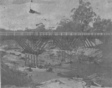
Photograph, Campbell’s Bridge over the Wimmera River 1961
Newly built Campbell’s Bridge over the Wimmera River. Built by Redman Bros. Opened in 1961.stawell shire -
 Stawell Historical Society Inc
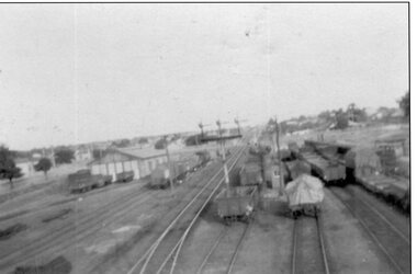
Photograph, Stawell Railway Yards viewed from the Step Bridge 1930's -- 2 Photos
Two B/W Stawell railway yards. Taken from step bridge 1930's.stawell transport -
 Eltham District Historical Society Inc
Photograph, Tillings timber yard, Bridge Street, Eltham, 1968, 1968
Photographer is standing on Bridge Street looking east on the main road to Greensborough from Eltham. Bridge Street under re-construction. Across the road from Tillings timber yard is Sharmac Industries which was a factory now occupied by Bunnings. It gave off a bad smell. This was the main light industrial area in the Shire of Eltham. Digital copy of colour photographfred mitchell collection, 1968, eltham, bridge street, n.j. tillings, tillings timber yard, light industrial area -
 The Beechworth Burke Museum Research Collection
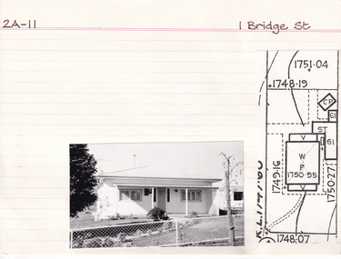
Card (Series) - Index Card, George Tibbits, 1 Bridge Street, Beechworth, 1976
George Tibbits, University of Melbourne. Faculty of Architecture, Building and Town & Regional PlanningIndex system that support the research for Beechworth : historical reconstruction / [by] George Tibbits ... [et al]Arranged by street names of BeechworthEach index card includes: street name and number of property, image of property, allotment and section number, property owners and dates of ownership, description of the property according to rate records, property floor plan with dimensions.beechworth, george tibbitsbeechworth, george tibbits -
 Eltham District Historical Society Inc
Negative - Photograph, Warrandyte Bridge over River Yarra, c.1910
View of the 1875 timber trestle bridge over the Yarra River reproduced from a newsprint image. Also known as Anderson's Creek (Road) Bridge A contract was accepted for William Elliot to erect a bridge over the Yarra River at Warrandyte on Anderson's Creek Road and other improvements for £1,331.6.2 - Gazette No. 143. Tuesday, November 13th 1860 - http://gazette.slv.vic.gov.au/view.cgi?year=1860&class=general&page_num=2161&state=V&classNum=G143&id=). The bridge was washed away by floods in 1863. It was replaced with a taller timber trestle structure in October 1875, designed and built by C.S. Wingrove, Shire Clerk, Engineer and Surveyor for Eltham Shire Council. A replacement for this bridge was commenced in 1955 to cope with increasing traffic and this structure was widened in 2018 to meet further traffic demands. Argus (Melbourne, Vic. : 1848 - 1957), Thursday 23 September 1875, page 7 ________________________________________ THE WARRANDYTE BRIDGE. The ceremony of formally opening the newly erected bridge over the Yarra at Ander-son's Creek was performed on Monday last, in the presence of the members of the Eltham and Bulleen shire councils whose territories it joins, and a goodly number of the residents of the district. The task was delegated to Mr. Cameron, M.L.A., who, after a few introductory remarks declared the bridge to be opened, and christened it the " Warrandyte Bridge." The party then adjourned to Grant's Hotel, where a cold collation had been prepared. The chair was taken by the president of the Eltham shire (Mr. John Bell) and the vice chair by Mr. Kent, a member of the Bulleen council. Mr Robert Williamson proposed "Success to the bridge," coupling with it the name of Mr. Cameron, to whose exertions was in the main to be attributed the erection of that structure which was an ornament to the district and would prove of great service to both sides of the river. Mr. Cameron, in responding, alluded to the great difficulties, mainly of a pecuniary nature, that had been encountered in carrying out the project, and which had only been got over by their united efforts and by the liberal spirit in which the late Commissioner of Roads had dealt with the case. The healths of the contractor and the engineer were also drunk. The bridge is a trussed timber one, resting on yellow box piles sunk into the solid rock, each pier being weighted with 50 tons of stone. The abutments consist of dry stone walls, 6ft. thick at the base, and tapering to 3ft. on the top, the face of the work having a batter of 1 to 1. The length of the bridge is 308ft., there being four openings in the centre of 66ft. each, and two at the ends of 20ft. each. The width in the clear is 9½ft., and the height from the bed of the river about 33ft. The approaches comprise 1,100 cubic yards of earthwork, and the formation of 48 chains of sideling, the whole cost of the work, which was carried out under the direction of the engineer to the Eltham Shire Council, being £1,413.This photo forms part of a collection of photographs gathered by the Shire of Eltham for their centenary project book,"Pioneers and Painters: 100 years of the Shire of Eltham" by Alan Marshall (1971). The collection of over 500 images is held in partnership between Eltham District Historical Society and Yarra Plenty Regional Library (Eltham Library) and is now formally known as the 'The Shire of Eltham Pioneers Photograph Collection.' It is significant in being the first community sourced collection representing the places and people of the Shire's first one hundred years.Digital image 4 x 5 inch B&W Neg B&W Print 12.5 x 9 cmsepp, shire of eltham pioneers photograph collection, warrandyte, bridge -
 Eltham District Historical Society Inc
Photograph, Widening of Main Road Bridge over Diamond Creek, Eltham, c.1984, 1984c
Four colour photographs showing road works for widening of the Main Road bridge over Diamond Creek; two showing Main Road south of Mt Pleasant Road and one from the corner of Antoinette Blvd, Eltham, Vic.eltham, main road, diamond creek, main road bridge, bridges, construction -
 Ballarat Tramway Museum
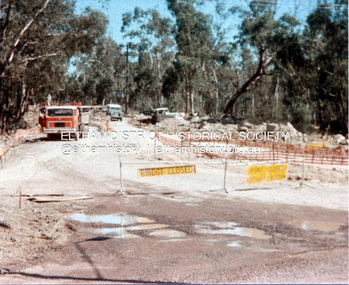
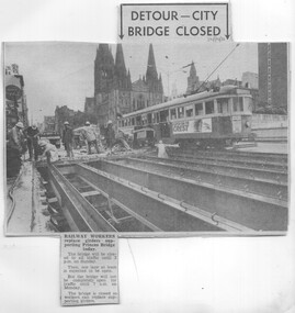
Newspaper, Herald & Weekly Times Ltd, "Detour - City Bridge Closed", 24/10/1970 12:00:00 AM
Newspaper Clipping from The Sun newspaper 24/10/1970 about the replacement of bridge girders in Swanston St. over the Railway lines with W2 381 in the background. Gives details of road closure. Good photo of the type of structure."24/10/70" in blue ink in top left hand corner.trams, tramways, swanston st., mmtb, bridges -
 Lakes Entrance Historical Society
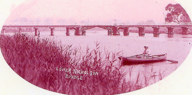
Photograph - Bridges, 1900
Opened March 1889, centre lifting span unsuccessful so shipping trade up Nicholson River effectivly terminatedPink toned scanned photograph of the first bridge across the Nicholson River. Shows a timber bridge with centre designed as a drawbridge. Woman in rowing boat in foreground. Nicholson VictoriaNicholson River Bridgebridges, waterways -
 Eltham District Historical Society Inc
Folder, Warrandyte Bridge, 1999
Printouts marked "M Houghton" (Murray Houghton was a local historian from Warrandyte Historical Society) headed "literature search - second Warrandyte bridge" with transcriptions from outward correspondence letter book files from Eltham Shire Secretary and Engineer C.S. Wingrove to various parties 1874 - 1879 which relate to the bridge at Warrandyte. 11 pagesHG Booklet 21batt, batt's hotel, brock, c.s. wingrove, christmas hills, eltham shire council, harry gilham collection, kilpatrick, road construction, victoria hall, war memorial, warrandyte bridge, wingrove, yarra flats, yarra glen -
 Eltham District Historical Society Inc
Negative - Photograph, View, Bridge Street, Eltham, c.1890
View towards Montmorency Estate from Main Road, Eltham about 1890. Looking down Bridge Street across the bridge (1875). At the corner of Susan Street is the Hill family home. Reproduced in "Montmorency; the farm on the Plenty" by Maureen Jones, 2015, p43 - 'View towards Montmorency Estate from main Road, Eltham, c.1890'This photo forms part of a collection of photographs gathered by the Shire of Eltham for their centenary project book,"Pioneers and Painters: 100 years of the Shire of Eltham" by Alan Marshall (1971). The collection of over 500 images is held in partnership between Eltham District Historical Society and Yarra Plenty Regional Library (Eltham Library) and is now formally known as 'The Shire of Eltham Pioneers Photograph Collection.' It is significant in being the first community sourced collection representing the places and people of the Shire's first one hundred years.Digital image 4 x 5 inch B&W Negshire of eltham pioneers photograph collection, eltham, bridge street, bridge street bridge, hill family home, montmorency, susan street -
 Eltham District Historical Society Inc
Photograph, Old Lower Plenty Bridge, c.1970
Old bridge across the Plenty River at Lower Plenty now part of the Plenty River Trail. Part of a slide show presentation "Bridges & Waterways of the Shire" by Russell Yeoman to the 13 September 1989 Society meeting. The presentation included slides of historic photos from the Shire of Eltham Pioneers collections as well as several recent views.Black and white photographmain road, plenty river, bridge, lower plenty, plenty river trail -
 Eltham District Historical Society Inc
Negative - Photograph, Russell Yeoman, Old Lower Plenty Bridge, c.1970
Old bridge across the Plenty River at Lower Plenty now part of the Plenty River Trail. Part of a slide show presentation "Bridges & Waterways of the Shire" by Russell Yeoman to the 13 September 1989 Society meeting. The presentation included slides of historic photos from the Shire of Eltham Pioneers collections as well as several recent views.Roll of 35mm black and white negative film, 4 of 7 stripsIlford HP4bridge, lower plenty, main road, plenty river, plenty river trail -
 Eltham District Historical Society Inc
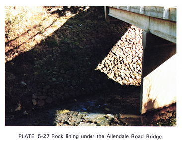
Work on paper (Sub-Item) - Photograph, Rock lining under the Allendale Road Bridge, 1976
Colour photograph of rock lining along the Diamond creek under the Allendale Road Bridge, Eltham Northrock lining, bridge, eltham north, diamond creek -
 Greensborough Historical Society
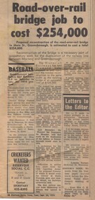
Newspaper Clipping - Digital Image, Diamond Valley News, Main Street Road and Rail Bridge job to cost $254,000, 1974, 24/09/1974
Proposed reconstruction of the road-over-rail bridge in Main Street Greensborough was expected to cost $254,000 in 1974. Digital copy of newspaper clipping, black text.main street greensborough, greensborough station, rail bridge greensborough -
 Greensborough Historical Society
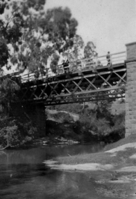
Photograph - Digital image, Bridge over Plenty River, 1930-1940
Photograph of old bluestone bridge over the Plenty River in Greensborough. This photo is from the Lorraine Coates Collection.Digital copy of black and white photograph.plenty river greensborough, bluestone bridge greensborough -
 Greensborough Historical Society
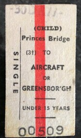
Ticket - Digital Image, VicRail, Train ticket: Princes Bridge to Aircraft or Greensborough, Child, 1977, 30/12/1977
Digital image of "Princes Bridge to Aircraft or Greensborough" child's train ticket, single journey, November 1977. Part of a collection of miscellaneous historical images with a connection to the local area.Digital image of train ticket. White with red strip and black text.train tickets, greensborough station, princes bridge -
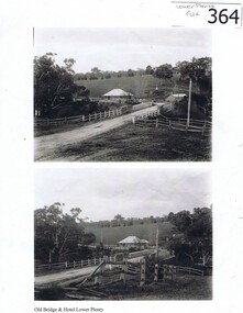 Greensborough Historical Society
Photograph (copy), Old Bridge and Hotel Lower Plenty, 1925c
2 historical views of the Lower Plenty bridge and hotel. Original photographs are in the Victorian State Library collection.Both the bridge and hotel remain but are in a very different landscape. This shows the area about 110 years ago.A4 photocopy of 2 black and white photographslower plenty, lower plenty hotel, plenty river, lower plenty river bridge. -
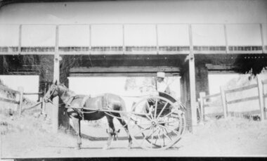 Stawell Historical Society Inc
Photograph, Deep Lead -- Bunyip Bank Rail Crossing up-grade with a horse & cart in font of the bridge.1933-1934
Deep Lead Bunyip Bank Rail Crossing being up-graded 1933- Buggy in front of bridge.stawell transport railways -
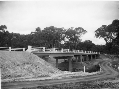
 Eltham District Historical Society Inc
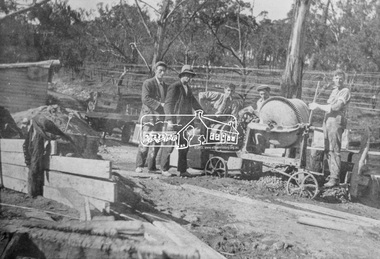
Photograph, Construction of the new concrete bridge over the Diamond Creek on Main Road, Eltham, c.May 1926
Construction of the new concrete bridge over the Diamond Creek on Main Road, Eltham, c.May 1926. Viewed from northern approach looking east, the access drive running off Antoinette Boulevard parallel to Main Road is visible as well as the power lines that used to run in front of Eltham Park (Eltham Lower Park). Also visible is a tree situated beside the roadway. It is believed this is the same tree that remains today as a dead tree trunk immediately adjacent to the road verge armco near the corner of Antoinette Boulevard. The original long suspension bridge over the Diamond Creek on Main Road at Eltham collapsed during flooding of the Diamond Creek on October 13 and 14, 1923. The original bridge was built around 1840 for the coach road when Cobb & Co.'s coach was the only conveyance between Eltham and Melbourne. Widespread damage was done in Melbourne and surrounding areas by floods resulting from the overflow of the Yarra at many points along its banks. A temporary bridge rigged up was severely damaged by the flooding of the creek and was closed to vehicular traffic in April 1924. A new concrete bridge was constructed to replace it and by May 1926 all the concrete piles and abutments had been completed. The bridge was finally completed and opened for traffic in September 1926, almost three years after it initially collapsed.This photo forms part of a collection of photographs gathered by the Shire of Eltham for their centenary project book,"Pioneers and Painters: 100 years of the Shire of Eltham" by Alan Marshall (1971). The collection of over 500 images is held in partnership between Eltham District Historical Society and Yarra Plenty Regional Library (Eltham Library) and is now formally known as the 'The Shire of Eltham Pioneers Photograph Collection.' It is significant in being the first community sourced collection representing the places and people of the Shire's first one hundred years.Photo print 9 x 12.5 cmshire of eltham pioneers photograph collection, eltham, bridge, diamond creek (creek), eltham south, main road bridge, wingrove park, antoinette boulevard, significant tree, cement mixer, bridge construction -
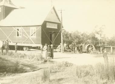
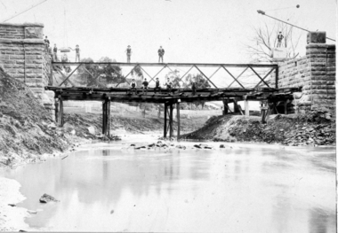 Clunes Museum
Photograph
PHOTOGRAPH OF BRIDGE UNDER CONSTRUCTION.CONSTRUCTION OF "GOVERNMENT BRIDGE" CLUNES.1896local history, photography, photographs, bridges -
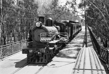 Eltham District Historical Society Inc
Photograph, VR Commissioner's Special train, steam locomotive D3-639 crossing the Echuca-Moama Road Rail Bridge over the Murray River from Moama, NSW to Echuca, Victoria, 1962
VR Commissioner's Special train, steam locomotive D3-639 crossing the Echuca-Moama Road Rail Bridge over the Murray River from Moama, NSW to Echuca, Victoria. Commissioner Edgar Henry Brownbill on footplate, 1962. Commissioner Edgar Henry Brownbill was in office 1957 to 1967. George Coop advises - "The train on the Eltham/Moama bridge is actually the Commissioner’s Special on one of its inspection tours of the VR rail system. This was a very grand special train with accommodation for the Commissioner and staff in carriages also used once for the Royal Train and other State purposes. You can just see the Commissioner of the day, dressed in his suit and wearing engine drivers gloves, standing in the loco cab doorway. A good ‘hands on’ impression is created amongst local staff if can be seen that the boss is no ‘desk jockjey’. The observation car on the back was originally made for the ’Spirit of Progress’. I climbed up onto the bridge iron plate work to get this view. It was safe enough as the cantilevered pedestrian walkway was still on the east side at the time." "I was resident in Echuca from Jan. ’59 to approx. May ’64. At that time the single Echuca/Moama bridge was a combined road/rail bridge. The rail gauge was 5’3” and still is, I believe, on the new bridge that sits just upstream of the old one. This rail line into NSW has always been 5’3" gauge because it has no connection with any NSW tracks. The old Echuca/Moama bridge, locally called the ‘Iron Bridge’ has, over years, undergone some structural changes. The two lattice iron hoops arcing over the roadway have been raised and lowered and changed design. Presently a pedestrian walkway is cantilevered off the west (or downstream) side of the bridge. It used to be on the eastern side. Guess changes went in when new rail bridge only was built on the eastern side as well." Image dated as c.1963 based on same image in Port of Echuca collection (possibly frame 32 of film) (print 19.5 x 24.5cm) On reverse in pencil: "Brown card" in black pen: "Commissioners special. F. Brown on Footplate. George C.L. Coop c1963". https://victoriancollections.net.au/items/59d575b921ea6e1278d78042 However based on frame no. 10, date set as 1962Digital TIFF file Scan of 35mm Ilford FP3 black and white negative transparencyd3-639, d3-class steam locomotive, echuca-moama road rail bridge, edgar henry brownbill, george coop collection, murray river, vr commissioner's special train -
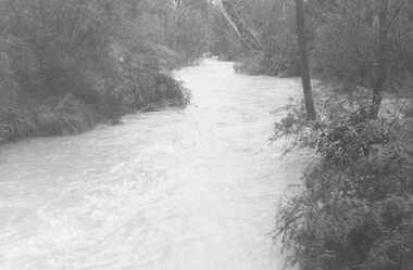 Ringwood and District Historical Society
Photograph, Mullum Creek in flood, July 1963. Taken from foot bridge at end of Adelaide St., Ringwood
See also 2982Typed below photograph, "Mullum Creek in Flood - 1963". Other photographs read, "Mullum Creek in flood, July 1963. Taken from foot bridge at end of Adelaide St." -
 Ringwood and District Historical Society
Photographs, 1979-80 MMBW pipe line project at Hubbard Reserve, North Ringwood � Track down to creek bridge
Part of a 43-photo record of the MMBW�s engineering feat in drilling a 12 inch pipe line up to 40 feet deep through rock hardened by volcanic action associated with geological fault that occurs along the line. The work took place from October 1979 to May 1980 on the southern boundary of Hubbard Reserve, North Ringwood. The collection was presented to the Ringwood Historical Research Group by J Clarke on 9th June 1980.E565 N12 13 May 1980 A43 My old track down to the bridge over the creek. The pipe line went to the right of the big tree 40-foot down. -
 Ringwood and District Historical Society
Photograph, Church of England relocation: About to cross bridge over Mullum Creek, Warrandyte Rd (undated)
Smaller photograph that appears to be the original from which this photograph was taken reads, "About to cross bridge over Mullum Creek, Warrandyte Rd. English Church" Appears to be Church of England. -
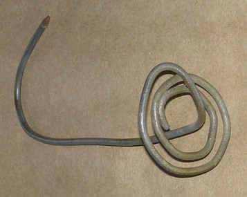 Heyfield & Districts Historical Society
Bill spike, George Edward Barraclough (1906-1981), 1940s-1950s
George Barraclough (1907-1981), a landholder from north of Licola, in the Victorian Great Divide, made a number of these spikes, as needed. As accounts were paid, receipts were pasted to the account, the account was impaled on the spike, and the spike was rehung on a nail on a wall stud. All transactions dealing with money were filed in this manner, as an orderly way of tracking items that were usually remotely ordered and delivered on the mail car. George Barraclough used No8 in a number of creative ways, and his durable and untilitarion toasting forks are still in family use today. After George died in 1981 the spikes with their accounts passed to his daughter Linda Barraclough, who archived the accounts and later made copies available for study. Those accounts form a record of the businesses of Heyfield for 1940s and 1950s.This bill hook is of historical significance as a survivor of bush ingenuity and bush filing systems. Commercially made bill spikes were in common use in offices, where they usually consisted of a heavy metal base with an upright pointed piece of wire. Number 8 fencing wire was an important and readily accessible repair commodity for rural dwellers, and achieved iconic status as the most generic method of repair for cars broken down (resort to nearest fence) and was even used to hold houses together. Referring to "No 8 fencing wire" became a type of Australian shorthand for bush ingenuity. It is no longer available, being replaced by 4mm high tensile wire. This item is important both as an example of inventive use of No8 wire, and also as an example of the bush filing methods in use in the 1940s and 1950s. No 8 fencing wire holds a similar position in New Zealand - see Wikipedia NZ at http://en.wikipedia.org/wiki/Number_8_wire A section of number 8 fencing wire twisted to form a bill spike. It has a rounded.base made from several twists of wire in a flat platform, with the remaining wire rising from the centre to form a stem that terminates in a hook with a sharpened point.wire, bush ingenuity, barraclough, licola north -
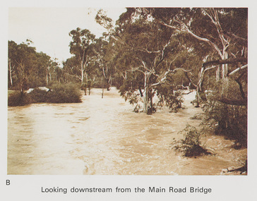 Eltham District Historical Society Inc
Work on paper (Sub-Item) - Photograph, Flooding, looking downstream from Main Road Bridge, Eltham 8 April 1977
Colour photograph. Looking downstream on the Diamond Creek from Main Road Bridge, Eltham , 8 April 1977. flood, diamond creek, flooding, main road, eltham -
 Malmsbury Historical Society
Photograph (Item), B/W Bridge Or Water Race Over A River, Malmsbury c1900
Associated with - Malmsbury Or Coolgardie? Buildings - "Bridge, Water Race" People - "Ellis, Florence Sarah; Ellis Godfrey William" -
 Eltham District Historical Society Inc
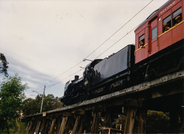
Photograph, Steam and electric trains on the the Trestle Bridge at Eltham, Nov 1992, 1992
Three colour photographs; one featuring an Hitachi electric commuter train and two of the Steamrail steam train which participated in the Shire of Eltham 1992 18th Community Festival as they crossed the Eltham Trestle Bridge. See also Photo 564.shire of eltham, festivals, trestle bridge, eltham, bridges, steamrail, steam train, hitachi electric train -
 Eltham District Historical Society Inc
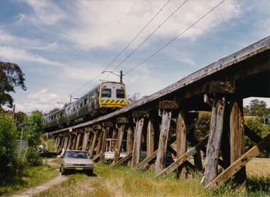
Photograph, Steam and electric trains on the the Trestle Bridge at Eltham, Nov 1992, 1992
Three colour photographs; one featuring an Hitachi electric commuter train and two of the Steamrail steam train which participated in the Shire of Eltham 1992 18th Community Festival as they crossed the Eltham Trestle Bridge. See also Photo 564.shire of eltham, festivals, trestle bridge, eltham, bridges, steamrail, steam train, hitachi electric train