Showing 1326 items matching "car park"
-
 Phillip Island Conservation Society Inc.
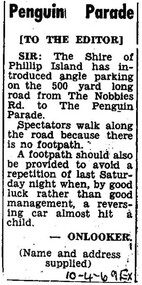
Work on paper - Photocopy of newspaper cutting, Editor, Wonthaggi Express newspaper, "Penguin Parade [TO THE EDITOR]", 10. 04.1969
... cars to be parked along the main road leading to the Penguin... not capped. It was not uncommon for many cars to be parked along ...This letter to the editor of the Wonthaggi Express newspaper was written by “ONLOOKER (name and address/supplied)” in 1969 at a time when the Phillip Island Penguin Parade was under the management of the Phillip Island Shire Council. There was very limited parking at the Penguin Parade at that stage, and visitor numbers on any night were not capped. It was not uncommon for many cars to be parked along the main road leading to the Penguin Parade. This was a cause of a great deal of concern as visitors to the Parade walked back to their cars in the dark along the main road after the Parade finished some hours after sunset. At that time there was no designated Phillip Island newspaper, with the Wonthaggi Express also covering some news from Phillip Island.The letter articulates the concern felt by many local residents and visitors to the Penguin Parade with regard to the lack of parking and other infrastructure for tourism on Phillip Island, and the Phillip Island Penguin Parade in particular. Having been published in the Wonthaggi local newspaper of the time, the Wonthaggi Express, also indicates that either there was no local newspaper being published on Phillip Island, or that the author submitted to both local newspapers in order to get their message across.Single column letter to the editor in 3 short paragraphs. Black ink on white paper. Photocopy of original article. 10-4-69 EX (referring to 10th April 1969, Wonthaggi Express newspaper)phillip island penguin parade, letter to the editor, parking problems, wonthaggi express newspaper, phillip island conservation society historical archive -
 The Beechworth Burke Museum
Photograph - Photographs, E. Yellard, c. 1950's
... with three cars parked in driveway turning circle in the foreground... with three cars parked in driveway turning circle in the foreground ...Two rectangular black and white photographs of the Beechworth Mental Hospital (Mayday Hills) administrative building showing the left and right hand sides of the exterior building with three cars parked in driveway turning circle in the foreground taken in the 1950's by E. Yellard. Mayday Hills Hospital, originally known as the Beechworth Lunatic Asylum was constructed between 1864-67 designed by The Public Works Department. The hospital is made up of a number of buildings, landscaping, ha-ha, workshops, laundry, administrative facilities and farmland, it was constructed in 'Italianate' style by a team of up to two hundred and fifty workers (Woods p. 122). The asylum was established in response to the need for the regional shire to locally care for those particularly affected by their time working the Ovens goldfield during the Indigo Shire gold rush era where poor living conditions and isolation were significantly affecting the welfare of a great many people through poverty and lack of resources. The gaol and orphan labour systems were not able to effectively support to give housing, rehabilitation and ongoing care for the mentally ill, and transporting to Melbourne by waggon was a time consuming and counter-productive solution when the metro facilities were already overcrowded. According to Woods (A Titan's Field p. 122), between 1901 and 1911 a large percentage (thirty five percent in 1901 and twenty four in 1911) of the Beechworth population were either patients or inmates of Beechworth institutions, Mayday Hills accounted for some six hundred and seventy four patients in 1901, Beechworth's Mayday Hills was chosen as the site of Victoria's newest asylum, at the time, due to the landscape and altitude. The hilltop atmosphere and the native fauna, it was argued, would assist in the cure of the patients kept at the hospital (Wood 1985, 122). The positioning of the hospital had a beneficial effect on the rural town and the large volume of people living at the hospital and contributing to this population growth is counted as reason for the survival of Beechworth as a regional township. According to the Victorian Heritage database, during the period 1921-1950 Mayday Hills underwent some modernisation by Public Works Department architect Percy Everett which included a nurses' hostel and new ward which were further developed and continued to function as a mental hospital up until 1995 when it was sold to LaTrobe university. The building and grounds are listed on the Victorian Heritage Register under criterion A, B, D, E and F.These photographs give a good indication of the ongoing use of Mayday Hills from its original establishment in the 1860's through to almost one hundred years later when these photographs were taken. The clarity of the images combined with the style and make of the cars in the foreground give a good indication of the time period and show the continued use and need for the facility over the years. Through images of building facades such as these, we might gain fuller understanding of the structural and aesthetic characteristics to be used in any future development or restorative work.2 x black and white rectangular photographs [copies] printed on Ilford photographic paper8688.1 reverse: Beechworth / Mental / Hospital / 80% 19cm / 12 cm / 80% / 728 / New / Print / BMM / 8688.1 / E. / Yellard / [Stamped : ILFORD] 8688.2 reverse: Beechworth / Mental / Hospital / E. / Yellard / BMM / 8688.1 / [Stamped : ILFORD]administrative building, black and white photographs, beechworth, mental hospital, beechworth mental hospital, mayday hills, cars, 1950, e. yellard, the public works department, public works department, hospital, mayday hills hospital, beechworth lunatic asylum, lunatic asylum, asylum, ovens goldfield, indigo shire, indigo shire gold rush -
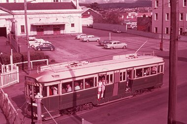
 Ballarat Tramway Museum
Photograph - Geelong 4 - Moorabool St, late 1930s
... angle-parked motor cars. The T&G building is finished. The bar... building, and many angle-parked motor cars. The T&G building ...The photo taken at the corner of Moorabool and Malop Streets is looking south along Moorabool St. Shows Geelong tram 4 with the destination of North, about to turn into Malop St with several passengers boarding the tram. In the background is a safety zone sign, the Solomons store, the T&G building, and many angle-parked motor cars. The T&G building is finished. The bar traffic lights don’t appear to be at the Moorabool and Ryrie St corner yet so the photo was taken between 1934 and 1939Yields information about Geelong late 1930s and tramway operations.Black and white photograph - plain back.geelong, moorabool st, malop st, tramways, tram 4, safety zone -
 Royal District Nursing Service (now known as Bolton Clarke)
Photograph - Photograph, black and white, 15 05 1967
... with the other parked Holden cars are part of the RDNS fleet of vehicles. ... with the other parked Holden cars are part of the RDNS fleet of vehicles ...The Royal District Nursing Service (RDNS) Sister is leaving Headquarters, 452 St. Kilda Road, Melbourne, to administer nursing care to patients in their own homes. The Sisters nursed patients referred by Hospitals and General Practitioners giving treatments, such as injections, wound care and doing other procedures, as well as assisting them with general care when required. The Sister is driving an Australian built Holden car of the 1960s which, along with the other parked Holden cars are part of the RDNS fleet of vehicles. From its inception in 1885 the Trained nurses (Nurses) of the then named Melbourne District Nursing Society (MDNS), later named Royal District Nursing Service (RDNS) gave high quality nursing care to patients in their own homes. They nursed patients referred by Hospitals and General Practitioners giving treatments, such as injections, wound care and doing other procedures, as well as assisting them with general care when required. From the early days the Nurses taught the importance of good hygiene, cleanliness, good nutrition in the prevention and curing of disease and in maintaining good health, as well as giving advice and support to the patient and their carers. The Sisters liaised with the patient’s Doctor. District has had various modes of transport over the last 130 years. At first the Nurses walked the streets and lane ways amid the slums of central Melbourne. As the Society expanded bicycles, public transport, District cars, the use of a Motor Auxiliary, nurses own cars, and even a motorcycle were used, and all these forms were intermingled until RDNS had its own fleet of vehicles. By 2009 there were 598 cars in the fleet and the nurses travelled 9 million 200,000 kilometres – this is equivalent to 12 trips to the moon and back. The Royal District Nursing Service (RDNS) building at 452 St. Kilda Road, Melbourne was originally called 'Airlie', the childhood home of Stanley Melbourne Bruce, the Prime Minister of Australia 1923-1929. RDNS, then named Melbourne District Nursing Service (MDNS) moved into this building as their Nurses Home and Headquarters in 1953. MDNS was given Royal patronage in 1966 and continued to occupy the building until 1996. 452 St. Kilda Road, Melbourne is listed on the Victorian Heritage Register. In the foreground of this black and white photograph are three cars on St. Kilda Road passing Arthur Street on their left. In the centre is a Royal District Nursing Service, (RDNS), Sister sitting at the driving wheel of her RDNS grey Holden car in Arthur Street, at the corner of St. Kilda Road. Behind the car are two round poles inset in the nature strip near the kerb; the pole on the right holds the street signs 'Arthur St' which points to the left of the photograph, and 'St Kilda Rd' points towards the number '452' attached to a square concrete column and metal spiked fence running down the right of the photograph behind the nature strip. In the background of the photograph is the corner view showing two sides, part in Arthur Street and part in St. Kilda Road, of RDNS Headquarters which is a large white two storey Italian style building, which has arched Arcadia on the ground floor, and an arched Arcade on the second floor; a flat roof with two chimneys is seen. A garden with trees can be seen running in front of both sides of the building and behind the cast iron spiked fence. In Arthur Street, to the left of the large building is a two storey white building with a tiled roof. It has a white solid fence in front of it Parked at the kerb in front of this building, and the section of RDNS large white building in Arthur Street, are three other RDNS grey Holden cars. Parts of a large trees are seen on the left and right of the photograph.Photographers stamp. Quote GE 46rdns, royal district nursing service, rdns transport, rdns headquarters -
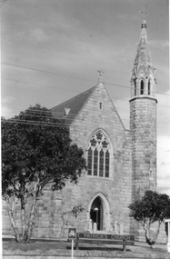 Stawell Historical Society Inc
Photograph, St. Patrick’s Catholic Church c 1965-1970
... of priest's residence on right. A car can be seen parked below... of priest's residence on right. A car can be seen parked below ...Views of St. Patrick’s Catholic Church. Two of the photos are identical showing the parish hall on left of photo and a small part of priest's residence on right. A car can be seen parked below the church fence. Photo recorded to be taken by Ruby Willy Estate. The other photo shows a different view with a timber sign out the front of the church and two trees either side of the sign. This third photo also just shows the priests house on the right and taken around 1965 -1970.Three black and white photos of St Patrick's Church. Two are identical showing parish Hall on left of photo and small part of priest's residence on right. The other photo of the church taken at a different angle shows two trees and a church sign out the front. Electricity lines can be seen across the photo.stawell -
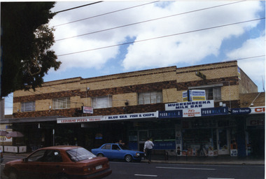 Glen Eira Historical Society
Photograph, Murrumbeena Road, 229-229A-231-231A-233, Murrumbeena, 2001
... includes parked cars, a person leaning on a car outside the fish... parked cars, a person leaning on a car outside the fish and chip ...Originally labelled "Beauville Estate, Established 1936, Still Thriving 65 years on, 10th March 2001", the Beauville Estate Album contains colour photographs of houses in the Estate. They were taken around the time of the Beauville Estate’s 65th Heritage Celebration held on 10/03/2001 and donated to the Caulfield Historical Society shortly afterwards. Photographer unknown. 227 Murrumbeena Road (Bev Baxter Chemist) is not part of HO12.City of Glen Eira’s Heritage Management Plan Vol 2 p79 (this is p84 of the pdf version) – HO12 Beauville Estate and environs, Murrumbeena: The Beauville Historic Area is important at the State level as the first large housing estate undertaken by the AV Jennings Construction Co, later Jennings Group Limited, Victoria’s largest home builder. It is important also as a very early estate development incorporating a range of features other than houses and including made roads, shops and recreation facilities. In this respect it was the forerunner of the comprehensively planned housing estate of the post war era. The estate is distinguished by its aesthetic values, as is the earlier and comparable Hillcrest Estate, which are formed by a combination of restrained diversity in house styles, with the exception of no. 30 in the emerging International style, and by a landscaped garden environment. Colour photograph of a group of commercial properties with ground level shops and upper level two toned brown, unpainted brick residences. The photograph taken from across the road also includes parked cars, a person leaning on a car outside the fish and chip shop and a pedestrian crossing the road. Shops shown are from left to right: Cafe Fresca, 231 Hair Creations, Leovorno Pizza, Blue Sea Fish & Chips, Murrembeena (sic) Milk Bar and a portion of the one storey shop Bev Baxter Chemist at the right end. LEOVORNO PIZZA / BLUE SEA FISH & CHIP / Herald Sun / Sunday / MURREMBEENA MILK BAR / PK's / SANDWICH BAR / Bev Baxtermurrumbeena, architectural styles, 1930's, inter war style, a.v. jennings, av jennings, jennings, beauville estate, murrumbeena road, commercial establishments, shops, pharmacies, milk bars, fish shops, sir albert victor jennings, a v jennings construction co, beauville estate heritage area, glen eira city council, architectural features, jennings group limited, land subdivision, beauville historic area, brick shops, brick features, hairdressers, pizza shops, restaurants -
 Ballarat Tramway Museum
Photograph - B&W print of donated negative, Ron E. Fluck, 1968
... the trolley pole back on. Two parked cars in the photograph. Photo... to assist in putting the trolley pole back on. Two parked cars ...Black and white print of a donated negative. Print made 8/1998. Photo of SEC tram at the Sebastopol terminus with the Royal Mail Hotel in the background. Photo taken during 1968. Tram still has destination of Sebastopol on north end, Fosters Lager sign on hotel and Twin Lakes sign on the tram. Tram overhead has the sheet metal device to assist in putting the trolley pole back on. Two parked cars in the photograph. Photo shows ground conditions at the terminus. Negative rescanned 9-5-2020 and image updated.tramways, trams, sebastopol, royal mail hotel, ballarat, 33, tram 33 -
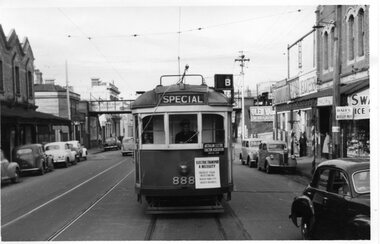 Ballarat Tramway Museum
Photograph - Black & White Photograph/s, Geoff Grant, 25/06/1955 12:00:00 AM
... Street railway bridge. Numerous parked cars of the era... Station, Victoria Street railway bridge. Numerous parked cars ...Black & white photo of M&MTB tram No. 888 from rear cab of 877 while on AETA tour of 25/6/1955 in Victoria Street, North Richmond, just to the west of the North Richmond Station, Victoria Street railway bridge. Numerous parked cars of the era in the street, and shops on both sides of street. Tram 888 has destination of "SPECIAL", carrying AETA auxiliary board and a board on front dash of tram that says "ELECTRIC TRANSPORT A NECESSITY , PROTECTS YOUR INVESTMEST, BUILDS YOUR CITY, CREATES BUSINESS"On typed paper on rear, "Shot out of the Rear cabin of 877 showing 888 tailing us on AETA Bourke St. tour. June 25 1955" and "Geoff Grant" stamp in btm rh cnr.trams, tramways, victoria st, bourke st, aeta, north richmond , tram 888 -
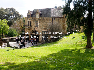 Eltham District Historical Society Inc
Photograph - Digital Photograph, Jim Connor, Eltham Cemetery Trust's launch at Montsalvat of Our Eltham - Artistic Recollections, 21 September 2017
... to the car park near Metery Road, are residents of the Eltham area... to the car park near Metery Road, are residents of the Eltham area ...Our Eltham - Artistic Recollections by Jim Connor, EDHS newsletter No. 236 October 2017 The Eltham Cemetery Trust, established in 1858, selected the existing burial site at Mount Pleasant Road on high ground overlooking the village of Eltham. The first recorded burial took place in 1861 in the Church of England section. Headstones depict the names of many early and well known local families. In recent years the Trust has encouraged the use of creative artistic elements within the natural bushland environment in their landscaped grounds adjoining Montsalvat. Their ongoing vision has been to offer the local communty a fresh and unique relationship to the Cemetery. On Thursday 21st September 2017 their latest commissioned art project titled ‘Our Eltham - Artistic Recollections’ was unveiled. It is a collection of panels collaboratively created by artist Nerina Lascelles and ceramicist Linda Detoma. The project was designed and constructed by Leigh Wykes using Australian stone with ironwork by Neil Carter. All contributors to this installation, located adjacent to the car park near Metery Road, are residents of the Eltham area. Our Eltham - Artistic Recollections is described as a celebration of life in the Shire since the opening of the Eltham Cemetery more than 150 years ago. Depicting scenes of life in and around Eltham, the collection offers deeper connections to the Eltham area through a series of visual narratives of Eltham’s past, environment and community. The project involves the artistic interpretation by Nerina Lascelles of historic and current images symbolically intermixed with locally indigenous flowers and plants. These are displayed on thirty-one ceramic panels by Linda Detoma, mounted within an iron fence by Neil Carter, upon an attractive rock wall constructed by Leigh Wykes. The Eltham District Historical Society is pleased to have contributed to this project. Russell Yeoman and Jim Connor from our Society have collaborated with Liz Pidgeon, Local and Family History Librarian at Yarra Plenty Regional Library on a selection of photographs, many from the Shire of Eltham Pioneers Collection we hold in partnership, located at Eltham Library. We also provided information on the images chosen. The Eltham Cemetery Trust has produced a booklet about this artwork, which can be viewed on the Cemetery website at: http://www.elthamcemetery.com/oureltham/#1 Our Eltham - Artistic Recollections is a significant monumental installation, which will encourage visitors to come to view this outstanding combination of local creative skills, set within the attractive grounds of the Eltham Cemetery. jim connor collection, eltham cemetery trust, montsalvat, our eltham artistic recollections, 2017-09-21 -
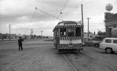
 Ballarat Tramway Museum
Photograph - Digital image, Wal Jack, 20/03/1949 12:00:00 AM
... area a number of angle parked cars. In the rear are Patersons... parked cars. In the rear are Patersons Furniture, Taylor ...Yields information the appearance of the SEC tramcar No. 23, which was often decorated in 1949 and the streetscape.Digital image from the Wal Jack Ballarat Album of trams No. 23 in Sturt St climbing the hill enroute to Gardens. Shows how the barrier rails were arranged. In front of the tram area a number of angle parked cars. In the rear are Patersons Furniture, Taylor and Taylor Chemists, Ballarat Fish Supply, Ritzy Cafe and Grill Rooms and a book store. The tram itself is looking shabby. Photo taken 20-3-1949. See image i2 for rear of photograph. See image i3 for hi res scan of print. See image i4 for hi res scan of negativeon rear of photo in ink, "SEC Ballarat, No. 23, in Sturt St, Ballarat 20-3-1949" and in top right hand corner Wal Jack copyright stamp with number "T99" written.trams, tramways, sturt st, city loop, tram 23 -
 Ballarat Tramway Museum
Photograph - Digital image, Wal Jack, 18/02/1940 12:00:00 AM
... . A number of parked cars in the view. Has a light streak... of the centre poles, with No. 31 in the distance. A number of parked ...Yields information about Lydiard St North at the time of the removal of the centre poles.Digital image from the Wal Jack Ballarat Album of a photograph looking south from Mair St along Lydiard St North prior to the removal of the centre poles, with No. 31 in the distance. A number of parked cars in the view. Has a light streak on the left hand side and the George Hotel. Wal's album notes "No. 31 in Lydiard St 18/2/40 central poles removed next day." See image i2 for rear of photograph. See image i3 for hi res scan of print. See image i4 for hi res scan of negativeOn rear of photograph in ink "T136 Ballarat No. 31 in Lydiard St a week before centre standards were removed. Photo W. Jack"trams, tramways, lydiard st nth, poles, tram 31 -
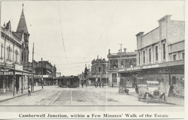 Melbourne Tram Museum
Photograph - Black & White Photograph/s, 1970's
... Road, c1920. Has a car (Ford Model T) parked in the street.... Has a car (Ford Model T) parked in the street and a motorcycle ...Black and white copy photograph from a Real Estate Poster of a bogie tram (HTT?) turning from Riversdale Road into Camberwell Road, c1920. Has a car (Ford Model T) parked in the street and a motorcycle. Camberwell Junction, Adair Bros, Wilson Real Estate Agents. Post office on the left hand side of the photo with the tower. Has title on photograph "Camberwell Junction, with a Few Minutes' Walk of the Estate"trams, tramways, mmtb, camberwell junction, camberwell rd -
 Rutherglen Historical Society
Post Card, various
... in Main Street, with cars of 1970s vintage parked along the street...., with cars of 1970s vintage parked along the street. Post Card ...Three black and white photographs of old postcards, mounted on a sheet of decorative grey paper. Top one is a view of Main Street, Rutherglen, looking west, featuring Younkman's Store and the Victoria Hotel. Middle one is also of Main Street, looking west, featuring the Star Hotel at the corner of High Street, with horses and carts in the street. Bottom one is of the Victoria Hotel in Main Street, with cars of 1970s vintage parked along the street.Centre photo has an upside down post mark: "Sydney | Jan 5 | 12 [illeg.] | 1909 | 75"main street, high street, star hotel, victoria hotel, s younkman & co -
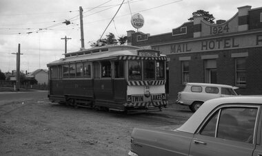
 Ballarat Tramway Museum
Photograph - B&W print of donated negative, Ron E. Fluck, 1968
... the trolley pole back on. Two parked cars in the photograph. Photo... to assist in putting the trolley pole back on. Two parked cars ...Black and white print of a donated negative. Print made 12/1998. Photo of SEC tram No. 33 at the Sebastopol terminus with the Royal Mail Hotel in the background. Photo taken during 1968. Tram still has destination of Sebastopol on north end, Fosters Lager sign on hotel and Twin Lakes sign on the tram. Tram overhead has the sheet metal device to assist in putting the trolley pole back on. Two parked cars in the photograph. Photo shows ground conditions at the terminus and taken at same time as Reg. Item 863. Driver turning the pole at the time. Negative rescanned 9-5-2020 and image updated.tramways, trams, sebastopol, royal mail hotel, ballarat, 33, tram 33 -
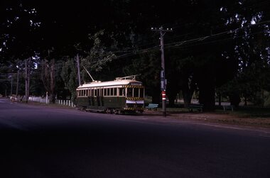 Ballarat Tramway Museum
Slide - 35mm slide/s - set of 2, Peter Moses, Jan. 1969
... and running south along Wendouree Parade - note the many parked cars... and running south along Wendouree Parade - note the many parked cars ...Set of two photos of SEC Ballarat No. 34 in Wendouree Parade at Gardens Loop. Tram has destination of "Mt Pleasant". .1 - No. 34 at the loop, waiting to depart. Note the signs on the poles and the seats at the stop. .2 - No. 34 has departed loop and running south along Wendouree Parade - note the many parked cars and trees in the street. Kodak cardboard mount slide, taken by Peter Moses assumed Jan. 1969, dated only "Jan", but date lines up with Bendigo slides and type of numbering. Could be 1970. See also Reg Item 3261 for photo used as Membership card for 2004 - 2005.On the rear of the slides in black ink "P. Moses" along bottom left or right hand corner in black ink.tramways, trams, wendouree parade, gardens loop, tram 34 -
 Charlton Golden Grains Museum Inc
Photograph, Charlton High St, centre south side c. 1994-95, c.1997
... building on LH side of photograph. Seven cars of various colours... of photograph. Seven cars of various colours parked in front ...Charlton Bakery established by Peter Klunder in 1876. Bakery owner in 1994 was Alan Tallentyre. Charlton Courier, previously the Charlton Tribune, closed c. 1996. Manchester Unity Office previously located in shop at western end of High St.Colour photograph of Charlton Bakery, Charlton Courier office and Manchester Unity office. Two storey State Bank building on LH side of photograph. Seven cars of various colours parked in front of the buildings. Signage on top of the buildings shows "Charlton Bakery" and "Courier". Tow different coloured green roofs on the verandahs and cast iron decoration on the verandah of the Courier/Manchester Unity building. Charlton Printing and Charlton Courier written on windows of the Courier office.charlton bakery, peter klunder, charlton courier, charlton tribune, manchester unity, charlton high st, charlton, business, industry -
 The Beechworth Burke Museum
Photograph, 1960s
... , and a parked car. Lake Sambell Caravan Park opened in 1959 owing..., and a parked car. Lake Sambell Caravan Park opened in 1959 owing ...This photograph was taken in the 1960s at Lake Sambell Caravan Park and visible in the photograph are individual caravan sites with electricity outlets, a large single-story building with a caravan park banner, dirt roads, a freestanding message board, and a parked car. Lake Sambell Caravan Park opened in 1959 owing to the work of R.E. Carter, Beechworth Shire engineer from 1954-63. Carter advocated for improvements to the lake and surrounding area in order to encourage tourism in Beechworth. The opening of the caravan park was part of many improvements to Lake Sambell made in this period by Carter including: the swimming pool in 1961, water skiing and boating facilities, and increased lake surface in 1964. These improvements were financed mainly by grants from the Tourist Development Authority. The popularity of caravanning in Australia exploded during this post-war period of the late 1950s and 1960s. This popularity was driven by multiple factors, including: the stopping of fuel rations, the accessibility of car ownership through the manufacturing of affordable cars, technological developments in caravan design, and the increase in prosperity and leisure time for many Australians. Facilities such as electrical outlets to power caravans are present in this photograph of Lake Sambell Caravan Park. Lake Sambell is an artificial lake that was developed on the previous site of the Rocky Mountain Mining Company workings and was officially opened by Minister for Lands, Mr Baily, on October 5, 1928. The disused and unattractive remains of the mine were converted into a recreational area intended for swimming, boating, and fishing. The lake is named after Mr L.H. Sambell, shire engineer and secretary of the Forward Beechworth Committee, who advocated for the enhancement of Beechworth into a tourist destination and was central to the planning and establishment of the lake. This photograph is of historical and social significance in providing insight into caravanning during the 1960s in Australia. Caravanning was extremely popular during the 1960s in Australia due to multiple social and economic factors including the stopping of fuel rations, the accessibility of car ownership through the manufacturing of affordable cars, technological developments in caravan design, and the increase in prosperity and leisure time for many Australians.Black and white rectangle photograph printed on photographic paper and unmounted.Reverse: 3536/ [logo back printing: KODAK/ VELOX/ PAPER] / C798 lake sambell caravan park, lake sambell, caravanning 1960s, caravan park, rocky mountain mining company, kodak velox paper, r.e. carter, l.h. sambell, caravan electricity outlets, tourist development authority, post-war prosperity, forward beechworth committee, lake sambell boating, lake sambell swimming pool, lake sambell fishing, artificial lake, travel 1960s, recreation 1960s -
 University of Melbourne, Burnley Campus Archives
Plan, Student Amenity Building (Citriodora) Courtyard, 1988-2000
... copies Entry from Rear Car Park Paving Plan. (15) Plan... copies Entry from Rear Car Park Paving Plan. (15) Plan ...Various plans for what is now known as the "Citriodora Courtyard." I copy tracing paper, 1 coloured original, 4 copies with additional notation 6 smaller copies with additional notation. (1) Planting Plan Plant Science Area V.C.A.H. Burnley designed by J. Hitchmough, drawn by S. Mullany 3 October 1988. (2) Student Amenity Quad Sketch Proposal by M. Green May '95. (3) Rough pencil design, New Design related to Horticultural pursuits of Burnley College. (4) Coloured, Proposed Citriodora Court Redevelopment. (5) 2 copies Citriodora Courtyard Presentation Concept Plan by Adrian Bonifacio. November 2000. (6) Landscape Graphics II Assoc. Diploma in Horticulture (Amenity) Assignment 2 - Planting Plan May 1988. (7) Laminated, Preliminary Plan 2 of 4 Citriodora Lawn Burnley by Kate Szmal B.A.S.H. (8) Laminated, Preliminary Plan Student Amenity Building Courtyard V.C.A.H. Burnley by Caroline Lodge. (9) 1 tracing paper and 1 paper copy University of Melbourne Burnley College Student Amenity Building Courtyard 19.8.99. (10) Setout Plan, Planting Plan & Surface Finishes, Details Courtyard & Entrance, ACM Landscape Architecture: Concrete Paving Topsoil, Mulch - notes. "Phil Tulk," handwritten on reverse. (11) Laminated, V.C.A.H. Preliminary Plan p3 of 5 Project No 1 Student Amenity Building Courtyard by K. Watson 15-8-95. (12) Citriodora Courtyard Redevelopment Concept Plan by Judy Brookes November 2000. 2 copies of Drawing 1 of 2, 1 copy Drawing 2 of 2. (13) Proposed Outdoor Eating Area Student Amenities Block: Scheme 1 pp 2-5 of 5, 16.10.96. Scheme 2 pp 3-5 of 5, 16.10.96. Scheme 8 3 copies p1 of 2, 2 copies p2 of 2, 23.6.97, Paving Types p1 of 1, 30.9.99, handwritten on reverse,"to Phil from Nicki." (14) 2 copies Entry from Rear Car Park Paving Plan. (15) Plan by Margaret Kitching 8.8.90. citriodora courtyard, vcah, centenary courtyard, plant science area, k. watson, s. mullaney, j. hitchmough, judy brookes, kate szmal -
 Eltham District Historical Society Inc
Postcard - Photograph postcard, Panorama at Eltham, Vic, c.1923
... would be present day CLC car park looking southwest across... would be present day CLC car park looking southwest across ...The Rose Series P. 4284 post card Taken from near what would be present day CLC car park looking southwest across Diamond Street, present-day Andrew Park to the railway station and developing Eltham shopping precinct. Arthur Street visible, Pryor and Luck Street not evident. Sunnybrook, the Taylor home is visible at the top of the hill in Bible Street. Only three residences visible in Arthur Street on the southern side, two of these are the David Harbison Rest Home at 10 and 12 Arthur Street (built and opened in November 1919), present day site of Eltham Mall. There are none on the north side of the street. Based on 1945 aerial view there are 8 buildings on the northern side between Main Road and Bible Street which and given the extent of commercial development on Main Road, it is estimated this image is circa 1925. Luther Haley was the first to build an open a baker and General Store in this location next to the railway station in 1902. However, it took nearly twenty years until the early to mid-1920s when a period of significant growth in the Eltham shopping centre happened with many businesses relocating their operations from the original town centre of Maria Street in Little Eltham as well as new businesses opening. Other stores/buildings noted (L-R) are: Stationmaster's House built circa 1910 Eltham Hardware Store opposite the railway station first opened on Main Road opposite the Railway Station around late 1922. An advertisement placed in the Hurstbridge Advertiser advised that the Hardware Store had just opened with a varied stock of Saws, Hammers, Nails, Shovels, Screw Drivers, and every article required in a house or on a farm. People were also encouraged to try their Jams, Pickles, Sauces, Cups and Saucers, etc. Newsagency with 'Leader' advertising on awning - E. J. Andrew opened his newsagency shop opposite the station in March 1923, advertising for sale stationery, school requisites and periodicals. Bird Brothers Cash Grocer & Fruiterer opposite the railway station offering summer drinks and confectionery a specialty with a full Stock of groceries of the best quality always on hand at city prices opened December 1921 William Capewell's Butcher shop at the corner of Dudley Street. Capewell previously had a small shop in front of the station opposite Luck Street. He enlisted in the AIF during WW1 and returned home in 1919. He re-applied for a slaughtering license in February 1920 and was advertising by October 1922 supplying all districts. Not visible (or not yet identified) but in business by October 1922 were: J.H. Fraser, Carpenter and Builder at Luck Street opposite the station George A. Danslow, Hairdresser and Tobacconist opposite the railway station Miss Barber's 'Blue Gum' Soda Fountain opened October 1922 opposite the railway station (hidden behind Stationmaster's House). It was so named due to its proximity to a tall Blue Gum tree G.H. McDonald Boot Repairer opposite the railway station In December 1923 the first portion of the main street to be formed from Dudley to Arthur streets was almost completed. This is the section in front of Capewell's Butcher shop though it is difficult to fully make out from the photoDigital file only Postcards scanned from the collection of Michael Aitken on loan to EDHS, 2 Sep. 2022michael aitken collection, eltham, postcards, arthur street, david harbison rest home, electrine candles, eltham railway station, eltham shopping centre, lloyd's general store, red rattler, rose series postcard, rose stereograph company, tait train, velvet soap, andrew park, bible street, bird brothers cash grocer & fruiterer, bird brothers cash grocer and fruiterer, butcher, diamond street, dudley street, eltham hardware and timber, eltham hardware store, eltham mall, main road, station masters house, stationmaster's house, sunnybrook, w.j. capewell, w.j. capewell butcher shop -
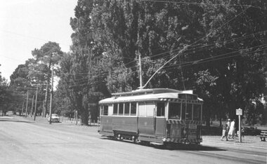
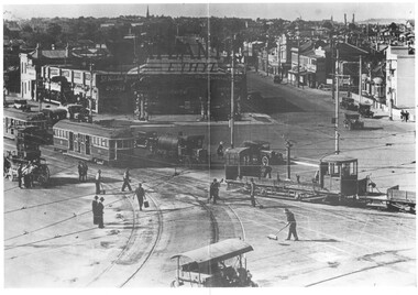
 Ballarat Tramway Museum
Slide - 35mm slide/s - set of 9, Noel Simons, Sept. 1971
... and car park in background. Taken from the signal box. 1174.2... of passengers. Railway station building and car park in background ...Set of 9 Kodak Ready-mount with slides made from the Association of Railway Enthusiast Provincial Tramways film strip. Reference Item 2560 details the ARE Film Strip, and provide references to other slides. See also Reg. item 1164. 1174.9 on plain white mount. 1174.1 - Tram 40 North bound for Lydiard St. North at the Railway Gates, with the gates closed. Tram carrying a heavy load of passengers. Railway station building and car park in background. Taken from the signal box. 1174.2 - Tram 12 bound for Gardens, photographed across the median strip plantation near Dawson St. Image i2a - adjusted 9/2021 to remove colour cast. 1174.3 - Tram 43 in bound along Wendouree Parade near Barrett Ave, passing a former tram stop and with "Warning Oncoming Trams" sign mounted on an adjacent pole. See also Reg. item 1172.1 for a photo taken in May 1971. This photo taken after the closure of the Victoria St. line, as the tram stop has been painted out. 1174.4 - Looking along the track to Sebastopol terminus on the west side of Albert St. - telephoto shot showing bogie tram in the far distance. Shows the nature of the track, poles, tram stop frequency and in the fare distance the terminus. Also show the trees that used to be along this section of the track. 1174.5 - No. 42 showing "Special" in Macarthur St. approaching Drummond St. north. Photo taken from under the verandah of a shop on the south side of the street that were many years later to become the Tramcar Restaurant. Note metal fence to cemetery. 1174.6 - Nos. 21 (Sebastopol) crossing 14 (Lydiard St. Nth) at the loop between Sayle and Grey St. Photo taken looking south. 1174.7 - No. 12 bound for Mt Pleasant, in Bridge St. about to stop at the junction for the two routes. Telephoto photo looking west along Bridge St. with many cars in the photo. Very few people on the street itself. 1174.8 - No. 30 and 17 at the City Terminus, on the north side of Sturt St. Taken from the Post Office corner with the Town Hall in the background. 1174.9 - No. 39 inbound along Sturt St. West. with many cars on the road. Bus stop on a pole on the other side of the road.1174.1 - "No. 40 on Lydiard St. North service waits at the level crossing at Ballarat Railway Station." 1174.2 - "No. 12 bound for 'Gardens' seen across the centre plantation in Sturt St." 1174.3 - "Barrett Ave." 1174.4 - "The Sebastopol route near the terminus" 1174.6 - "Nos. 21 and 14 crossing at Sayle St. Loop on Sebastopol route" 1174.7 - "No. 12 at Eastern end of Bridge St." 1174.8 - "Nos. 30 and 17 in Sturt St. at Cnr of Lydiard St." 1174.9 - "No. 39 City bound from 'Gardens" in Sturt St. West" All have date stamp of "Sep 1971" in black ink. Writing in blue ink.tramways, trams, lydiard st. nth, railway crossing, sturt st, wendouree parade, sebastopol, macarthur st., bridge st., sturt st. west, tram 12, tram 14, tram 17, tram 21, tram 30, tram 39, tram 40, tram 42, tram 43 -
 Ballarat Tramway Museum
Photograph - Black & White Photograph/s, Ron Hann, Jan. 1963
... - shows the track in the foreground, the gardens and parked cars..., the gardens and parked cars. Source of photo - same as Reg item ...Yields information about the Gardens terminus at the time and the view across to the Gardens.Black and white print on heavy matt photographic paper: 3847.1 - No. 20 at the Gardens Loop with a family, walking away from the tram. See also Reg Item. 473 for another print of the same photograph. Photo taken looking at rear of tram, with a family walking away from the tram towards the Gardens Pavilion (Lake Lodge in 1997). Has two ads beneath the drivers windows, one about the dancing, the other cannot be read. See Reg Item 3847 for another print of the same photograph. 3847.2 - Looking across to the Gardens from the Gardens Loop tram stop - shows the track in the foreground, the gardens and parked cars. Source of photo - same as Reg item 3841 - Ron Hann, note added 2/2010.On rear in pencil "20 Gardens 1963" and "1.45x2" and "Gardens Loop 1963"tramways, trams, gardens, wendouree parade, tram 20 -
 Glen Eira Historical Society
Document - Glen Eira Residents Association
... construction of car parks at Caulfield Racecourse. 2/A copy of Glen... construction of car parks at Caulfield Racecourse. 2/A copy of Glen ...Six items pertaining to Glen Eira Residents Asssociation Inc. 1/Two copies of the minutes of a Committee Meeting of Glen Eira Residents Association Inc., held on 04/12/2001. The minutes cover a range of routine meeting items, as well as the postponed release of the Princes Park Master Plans and the proposed construction of car parks at Caulfield Racecourse. 2/A copy of Glen Eira Residents’ Association Inc.’s 30/05/2003 newsletter, notifying members of matters presently before Glen Eira City Council for purposes of evaluation. Matters include an admonishment to the Council to sort out anomalies between the C25 Amendment (80/20 Plan) and the Melbourne 2030 Plan, the success at convincing the Ministerial panel to adopt GERA’s views regarding the C14 Council Plan for the Caulfield Racecourse, a request for information from the Council regarding the previous year’s rate increase, a request for information from the Council regarding spending on planning for improvements to Princes Park, a call for the Council to improve its consultative procedures, a recommendation that the purpose of Glen Eira News be expanded to the making of suggestions for city improvement, and a notification of the measures implemented to improve the visibility of Caulfield Racecourse’s usability by the public. Includes a black-and-white photograph of Orrong Road, Elsternwick, illustrating what Glen Eira’s roads would look like if lined with trees, which was excluded from Glen Eira News on account of a current prohibition on the making of suggestions for city improvements. 3/Four copies of a booklet entitled ‘A Short Guide to Planning Procedures’, composed 08/2006, which endeavours to explain, as concisely as possible, the methodology by which Glen Eira City Council approves real estate developments and issues planning permits. 4/A booklet containing the minutes of the 05/10/2009 Annual General Meeting of Glen Eira Residents’ Association Inc. Details both routine items and more specific matters of discussion, such as inappropriate charges on the part of the Glen Eira City Council and the proposed inception of a questionnaire to evaluate local residents’ opinion of the Council. 5/A booklet announcing the 07/10/2010 Annual General Meeting of Glen Eira Residents’ Association Inc. at St. John’s Uniting Church, Elsternwick. Front cover details agenda and contains four colour photographs pertaining to public transport (buses, trams, trains) within the city. Interior features president Don Dunstan reflecting on issues relevant to GERA occurring over the preceding twelve months, with an emphasis on the dubious behaviour of the City Council, as well as two colour photographs: one of Dunstan himself and one of traffic at Elsternwick Junction. The rear cover contains the Financial Statement presented to the Meeting. 6Two copies of a printout of an article from the website of Glen Eira Residents’ Association Inc., accessed 19/06/2012, explaining the affects wrought as a result of the implementation of Planning Scheme Amendment C87. Said amendment changes the Planning Scheme protecting neighbourhood character by replacing the previous Significant Character Area (SCA) designation with the new designations of Neighbourhood Character Overlay (NCO) and Design and Development Overlay (DDO). In developing the Amendment, Glen Eira City Council commissioned Planisphere to procure the Planisphere Final Report, in which recommendations regarding the expansion, creation and deletion of SCAs were offered. The article contains a summary of said recommendations.glen eira residents’ association inc., clubs and associations, glen eira, meetings, minutes, campbell jack, dunstan don, marwick geoff, pleydell max, teseriero dominic, robins kevin, princes park, south caulfield, glen eira city council, local government, councillors, brennan martin, victorian local government association (vlga), erlich mayor, project manikato, caulfield racecourse, caulfield racecourse flat, racecourses, parks, car parks, kennedy cr., kennedy norman mr., crown land, glen eira road, rippon lea, c25 plan (80/20), melbourne 2030 plan, c14 council plan, rates, orrong road, elsternwick, trees, station street, caulfield north, neerim road, glenhuntly, glenhuntly park, orrong ward, grossbard cr., martens cr., building permits, delegated planning committee (dpc), steward joy, brohier peter, campbell fliss, scutt alex, ray darren, hannah brian, st. john’s uniting church, mees paul dr., elsternwick club, sandham street, melbourne weekly bayside, glen eira debates, walsh investigation, whelen investigation, forge cheryl cr., whiteside helen mayor, save our suburbs (sos), walsh mary, walsh kevin, french christine, elsternwick junction, planning scheme, planning scheme amendment c87, significant character areas (scas), planisphere final report, oakdene crescent, carnegie, blackwood street, housing diversity areas, urandaline grove, caulfield, normanby road/park crescent, kambrook road, balaclava road, hawthorn road tramway estate, caulfield south, ulupna road, ormond, murray street, prentice street, kambea grove, chestnut street, mcpherson avenue, queens avenue, caulfield east, derby crescent, clarinda street, st. james parade/downshire road, exhibition street, mckinnon, field street, boyd park, murrumbeena, lindsay avenue, lydson street -
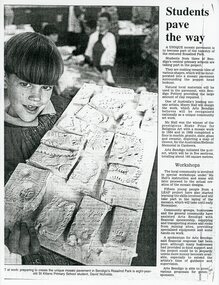 Bendigo Historical Society Inc.
Article - MERLE HALL COLLECTION: ROSALIND PARK CREATIVE VILLAGE BENDIGO NEWSPAPER ARTICLES, 1997
... a keen interest in the new-look base of the Rosaling Park poppet... a keen interest in the new-look base of the Rosaling Park poppet ...MERLE HALL COLLECTION: ROSALIND PARK CREATIVE VILLAGE BENDIGO NEWSPAPER ARTICLES 3858.9a Young boy holding a board of mosaic tiles probably at a workshop. Article begins: A unique mosaic pavement is to become part of the tapestry of the restored Rosalind Park. Students from three of Bendigo's central primary schools are taking part in the project. Photo Caption reads ART at work: preparing to create the unique mosaic pavement in Bendigo's Rosaling Park is eight year old St Killians Primary School student, David Nicholds. 3858.9b A newspaper coloured photo from the poppet head of two young people standing on and looking down on the mosaic at the lookout. Caption reads: Passing students take a keen interest in the new-look base of the Rosaling Park poppet head. The mosaic was created through an Art Bendigo project. LEAP workers helped install the five sections using stone tiles made by local primary school students. Depicting the saddle reef formations in the area the work has been designed and created by Bendigo artise Maery Hall. Picture: Peter Hyett. 3858.9c A photo from the poppet head lookout looking down at a worker with a broom, sweeping the mosaic. 3858.9d Two women crouching on the ground viewing the work done on the mosaic. One woman holds books and papers; in the far background over the car-park is the Sacred Heart Cathedral, the Bendigo Art Gallery and the Capital Theatre. 3858.9e Newspaper article along with coloured photo of the poppet head lookout in Bendigo's Rosalind Park. In the foreground are two young people arranging the mosaics. The article begins: Mosaic pavements began taking shape at the base of the Rosaling Park poppet head lookout yesterday. The pavement will cover about 130 square metres, in five sections, and have been designed as a memorial to Bendigo's mining history and traditions. 3858.9f Newspaper article July 29, 1997 entitled 'Bendigo Paving the Way' - photo of artist Maery Gabriel at the official opening of the heritage mosaic. Pictures: Tania Bond. Photo of Maery taken from the poppet head looking down on the mosaic. Als a smaller photo with details of the mosaic design. Opening paragraphs of the artical: Arts Bendigo and the City of Greater Bendigo are paving the way to an improved Rosalind Park with the official opening of the 'Bendigo Heritage Mosaic'. The mosaic is more than 100 square metres of decorated pavement sections surrounding the poppet head lookout at the park. The paving was designed by mosaic artist Mary Gabriel and depicts Bendigo's mining history and colour throughout. -
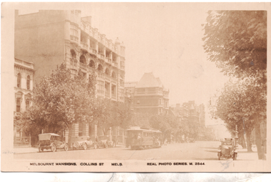 Melbourne Tram Museum
Postcard, Valentine's, "Melbourne Mansions Collins St Melb", 1919c
... . There are several parked cars and horse drawn wagons on the south side.... There are several parked cars and horse drawn wagons on the south side ...Postcard Real photo number M2844, titled "Melbourne Mansions Collins St Melb", by Valentine Sons. Featuring a west bound cable tram set in Collins Street between Exhibition and Russell Streets bound for Spencer Street, The trailer car appears to be No 52 and also has a non-standard destination box fitted on the side. The Melbourne Mansions Building. 91 - 101 Collins Street, was funded by David Syme proprietor of The Age newspaper and built in 1906. It is thought to be the first block of residential flats within the city limits. The building was demolished in 1958 to make way for Consolidated Zinc Building (CRA) completed in 1962. but since demolished. The large building further along Collins Street is the Austral Building completed in 1891. There are several parked cars and horse drawn wagons on the south side of Collins Street and an early Morris Oxford (Bullnose) on the northside. Behind that is one of the early ornate electric street lighting poles of the era. The photo has been taken around 1919 as the fourth floor addition to The Alexandra Club is visible in the photo. Unfortunately this particular copy of the photo has faded over time.Demonstrates a Valentine and Sons Real photograph postcard.Postcard - Real photograph - divided back unused.cable trams, collins st, tramways, tram 52 -
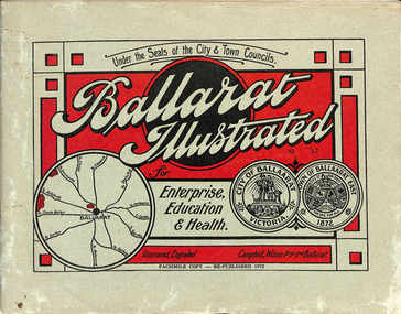 Ballarat Tramway Museum
Book, "Ballarat Illustrated", 1972
... on right-hand side of road. Car parked by Post Office has a car..., shows piles on right-hand side of road. Car parked by Post ...Original c 1914 (see below), facsimile copy - re-published 1972. Original features photos of Ballarat City and Town, its buildings, parks and the various industries and organisations that were in Ballarat at the time of publication, including ESCo. Many photos features ESCo trams. Photos sepia toned. Has some red colour block printing on the front cover and rear, for Star Oil Engines. On inside back cover is a map with the places of interest and tram route map, marked in red. Pages are un-numbered. Original published by Ballarat East Town Council and Ballaarat City Council. On cover has number stamped in black in, "No. 87" (assume facsimile copy No.). Photos with publication show tram No. 21, built 1913 and ESCo photo page shows Mr. Pringle as Manager. Mr Pringle became manager in January 1911, As there is no photos of the "Avenue of Honour", or other mention of the first world war, assume original published about 1913 or 1914. Original shows Engravings and printing by "Campbell Wilson Prop Ltd, Ballarat". See Other Information as well for more listing details. High Resolution image added 31/8/2012 of i2 of ESCo page and i3 for Ballarat identies and sheet i4 extracted for Mr Pringle. PDF scan of full document added 21/5/2019 - see images btm633-1i.pdf and btm633-2i.pdf Notes on "Ballarat Illustrated" Reg. Item No. 733 From notes made by Neville Gower 12/1/1997 Cover: Inside front cover: Last paragraph, "Facilities for Travelling" - Electric trams serve all parts of Ballarat. Page 3: Street Scene, Municipal Town Hall, showing tram wiring Page 7: Street Scene, Lydiard St. North, intersection and tramway centre, with ESCo tram No. 21 in the bottom photo. Other photos features trams as well in Sturt St and Lydiard St. North. Page 9: Street Scene, Top photo of Sturt St. from Lydiard St. looking east, shows piles on right-hand side of road. Car parked by Post Office has a car registration number "9007". Bottom photo, an tram climbing hill, shows double trolley in the street, with early English type of pull offs. Page 13: Street Scenes and Historic Buildings: One of five photos, shows Victoria St. looking East, with tram track prominent in photo and how stone work was set up about the rails and overhead poles. Page 23: Street scene, Gardens North Entrance gates, shows details of gates near St. Aidans Drive. Note double trolley wire on poles, and style of insulators. No trams in photo, three ladies walking down the track. Page 37: Street Scene; Lydiard St views, top left hand photo, shows Railway station and railway gates with signal gantry and horse drawn vehicles. Tram tracks apparent. Bottom left hand photo shows Lydiard St. North, near Post Office, double track with centre poles - Single wire per track. Top right hand photo, showing Cemetery gates in background. Bottom right hand photo - from north end of Lydiard St. South, looking north, with an ESCo tram in background. Also has a parked car on left hand side. Page 45: Street Scenes - Bridge St; top photo at west end of Bridge St. with ESCo No. 11 with possibly double trolley wire in photo. Bottom photo at east end of Bridge St. with tram in background, shows junction. Double trolley heading out to Mt. Pleasant, single trolley for Victoria St. Page 45: Street Scenes - Bridge St; top photo at west end of Bridge St. with ESCo No. 11 with possibly double trolley wire in photo. Bottom photo at east end of Bridge St. with tram in background, shows junction. Double trolley heading out to Mt. Pleasant, single trolley for Victoria St. Page 61: Street Scenes and Historic Buildings - Public Institutions Ballarat - top left hand photo of the Hospital shows some tram track in foreground, with double trolley wire. Top right photo is of the Orphanage, the name of the tram terminus for many years. Page 68: Electric Supply Co. of Victoria's pages - top photo showing powerhouse in background, across the lake, can hardly see anything for the trees, except for the chimney. Bottom photos of the steam Turbo Generators and the switchboard. Gives Mr. P.J. Pringle as Chief Engineer and General Manager. He took over in Jan. 1911. Page 69: Ballarat East Views - features photo of Black Hill open cut, Ballarat East Railway Station, Ballarat Fire Station and "Victoria St. looking East", repeat of photo printed on page 12, but slightly darker. Image on system includes fire station and railway station, - Ballarat East. Page 78: Series of photos of various Ballarat VIP's of the era, fourth one in on top line features "P.J.Pringle, Electric Supply Co." Inside Back cover - map of Ballarat including tram lines and places of interest marked in red. Gives a detailed photographic presentation of Ballarat in 1914.80 page book with, in addition, light green card covers, titled "Ballarat Illustrated". Loose copy of page 9 and 10 held.trams, tramways, ballarat, local history, heritage buildings, esco -
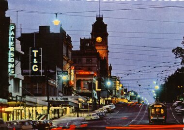 Ballarat Tramway Museum
Postcard, Nu-color-vue or Nucolorvue Productions, Sturt St at night, late 1960's or early 1970's
... parked cars in Sturt St, with red lines from the tail lights... signs. Has many parked cars in Sturt St, with red lines from ...Demonstrates post card making by a major postcard manufacture, late 1960's and yields information about Sturt St at night.Colour postcard with serrated edges of a Ballarat bogie tram at dusk in Sturt St, parked in City Loop. with Town Hall in background. Tram has destination of "CITY". Photo includes illuminated Paterson, T&G, Myer and the Vegas theatre signs. Has many parked cars in Sturt St, with red lines from the tail lights of vehicles moving on image. On rear , printed in dark green ink is the card details etc. "Ballarat, Victoria, Sturt St, Ballarat at dusk looking to the Town Hall." Nucolorvue card, BT 69. 2nd copy - in good order. See also Reg. Item 1176 for colour slide of this view. 960 copy 1 - made by enlarging postcard to an A4 print by colour photocopying and laminated for display purposes. Made July 2000 for the Trams at Night exhibition in the depot. Made by W.Doubleday. Has four Velcro dots on rear. Overall size 208H x 296W. Stored in same box at rear of large photos area in an A4 plastic folder. trams, tramways, ballarat, town hall, sturt st., tram 8 -
 Melbourne Tram Museum
Photograph - Illustration/s, Vintage Drivers Club, Mar. 1985
... of parked motors cars in the image. Reference Timeline History... a number of parked motors cars in the image. Reference Timeline ...Illustration from the centre page spread of "Vintage Driver No. 332 - March 1985" of the construction of St Kilda junction electric tram track with work on the paving and overhead being completed. Has tram 571 in the photos along with the Colas motor tank (tar?) , workmen sweeping the roadway, a road roller and the Ballast Motor 11 with a trailer being pushed. Photo c1930. Has the St Kilda Junction service station in the background. Photo possibly shows the resurfacing of the junction. Has a number of parked motors cars in the image. Reference Timeline History of Melbourne Tramway gives trackwork completed at St Kilda Junction, but the Ballast Motor being completed 1927, tram 571 entered service August 1929.trams, tramways, aeta, tours, ticket, south melbourne depot, hanna st depot, tram 571, tram 11 -
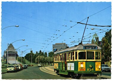 Ballarat Tramway Museum
Postcard, Nu-color-vue or Nucolorvue Productions, MMTB tram No. SW5 834 southbound in St Kilda Road
... in the background. Has as number of parked motor cars on either side... of Remberance in the background. Has as number of parked motor cars ...Colour postcard with serrated edges of MMTB tram No. SW5 834 southbound in St Kilda Road with the Shine of Remberance in the background. Has as number of parked motor cars on either side of the road. Tram is showing destination of "East Malvern - Darling Road", route 3. Has ads on ends and side of tram, but out of focus. One is for "Dufor Engine Valves" Card by Nucolorvue. On rear of card printed in dark green ink is "MELBOURNE, VICTORIA/ St. Kilda Road with tram and Shine of Remembrance." Also wording for stamp location, copyright etc. On left hand edges is "ML 132", Set EW. Second copy added 21/07/2001. Card is ML 132 NCV1106 - a lot more sharper or in focus card, different colours.trams, tramways, melbourne, st kilda road -
 Bendigo Military Museum
Photograph - Speedmaster Printing Press Media Announcement and Army Survey Regiment Open Day, Fortuna Villa, Bendigo, 1990
... , with civilian visitors. .25) - Photo, colour, 1990. Cars parked in Chum..., with civilian visitors. .25) - Photo, colour, 1990. Cars parked in Chum ...The first photograph was probably taken at a media event announcing the introduction of the Heidelberg Speedmaster printing press in late 1990. LTCOL Rene van den Tol was the CO of the Army Survey Regiment from 1989 to 1991. Partly obscured behind the CO was Mr Bruce Reid, who was the newly elected federal member for Bendigo. The media event was held in Wayzgoose Hall, Lithographic Squadron’s new purpose-built building constructed to house the Speedmaster 102 printing press. The remaining 29 photographs were taken at an Army Survey Regiment Open Day at Fortuna Villa, Bendigo on the 24th of February 1990. This occasion was one of several events held to commemorate the 75th anniversary of the formation of the Royal Australian Survey Corps. Although historical tours of Fortuna occurred on a regular basis, this was the first technical open day since 1972. The Royal Australian Survey Corps recognised that an Open Day was the best way for the local community in Bendigo to gain an insight into the unit’s important role as Defence’s map production agency, its technical equipment, and its economic importance to Bendigo. It also gave them an opportunity to tour through historic Fortuna Villa. This occasion is covered in more detail in page 143 of Valerie Lovejoy’s book 'Mapmakers of Fortuna – A history of the Army Survey Regiment’ ISBN: 0-646-42120-4. Refer to Item 6291.6P for more photos of the Open Day.The first photograph was probably taken at a media event announcing the introduction of the Speedmaster printing press at Army Survey Regiment Fortuna Villa, Bendigo in late 1990. The remaining 29 photographs were taken at an Open Day on the 24th of February 1990. The colour and black & white photographs were printed on photographic paper and are part of the Army Survey Regiment’s Collection. The photographs were scanned at 300 dpi. .1) - Photo, colour, 1990. L to R: Unidentified civilian visitor/media, SSGT Ian Nichols, unidentified (x2), SGT Dale Hudson (white top), unidentified (x2), MAJ John South, MHR Mr. Bruce Reid, CO LTCOL Rene van den Tol. .2) - Photo, black & white, 1990. WO1 Gary Warnest, civilian visitors. .3) to .4) - Photo, colour, 1990. WO2 Adrian 'Charlie' Creedy, civilian visitors. .5) - Photo, colour, 1990. Civilian visitors. .6) to .7) - Photo, colour, 1990. Civilian visitors, CPL Peter Peterson. .8) - Photo, black & white, 1990. L to R: LCPL Sandy Winn, civilian visitor. .9) - Photo, colour, 1990. L to R: CPL Steve McGuiness, civilian visitors. .10) - Photo, black & white, 1990. Display of digital storage media. .11) - Photo, colour, 1990. L to R: Mr Pat Thwaites outlining utilisation of satellite imagery to civilian visitors. .12) - Photo, colour, 1990. MAJ Peter Clarke with civilian visitors. .13) - Photo, colour, 1990. Unidentified technician with civilian visitors. .14) - Photo, colour, 1990. SGT Barry Hogan with civilian visitors. .15) - Photo, colour, 1990. SPR Ian Baldwin with civilian visitors. .16) - Photo, black & white, 1990. SPR Ian Baldwin with civilian visitors. .17) - Photo, black & white, 1990. SGT Sherri (Dally) Burke with civilian visitors. .18) - Photo, colour, 1990. L to R: SPR Jeanette (Lane) Dury-Lane, CPL Diane (Thomas) Soutar with civilian visitors. .19) - Photo, colour, 1990. L to R: unidentified technician, CPL Col McInnes, LCPL Charmian McKean. .20) - Photo, black & white, 1990. CAPT Peter Parkes. .21) - Photo, black & white, 1990. L to R: LCPL Janet Murray, MAJ Bob Coote, SPR Gary Lord. .22) - Photo, black & white, 1990. LT Marty Lyons with civilian visitors. .23) - Photo, colour, 1990. LT Marty Lyons with civilian visitors. .24) - Photo, black & white, 1990. SSGT Ian Nichols, CPL Dale Hudson, Planeta printing press, with civilian visitors. .25) - Photo, colour, 1990. Cars parked in Chum Street outside entrance to Fortuna Villa. .26) - Photo, colour, 1990. Civilian visitors near Fortuna Villa’s front door viewed from back gate. .27) - Photo, colour, 1990. Civilian visitors enjoying views of the garden from Fortuna Villa’s rooftop. .28) - Photo, colour, 1990. Civilian visitors enjoying views of the garden from Fortuna Villa’s verandah and rooftop. .29) - Photo, colour, 1990. Civilian visitors enjoying BBQ cooked by CPL Paul Baker and SPR Shona Hastie outside Lithographic Squadron. .30) - Photo, colour, 1990. BBQ cooked by CPL Paul Baker outside Lithographic Squadron..1P to .30P – no annotationsroyal australian survey corps, rasvy, army survey regiment, army svy regt, fortuna, asr, printing, litho -
 Ballarat Tramway Museum
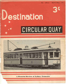
Book, Jack Richardson, "Destination Circular Quay", 1958
... buses, tram car ferry, Moore Park junction arrangements, notes... buses, tram car ferry, Moore Park junction arrangements, notes ...Forty page book including paper covers titled "Destination Circular Quay" edited by Jack Richardson, in association with N.L. Chinn and R.L. Young and published by Traction Publications, Destination Series No. 3 in 1958. Briefly details the tramways in Sydney operated by the Department of Government Transport, details each class of passenger rolling stock, with photographs, experimental cars, trailers, specialist cars, works trams, trolley buses, tram car ferry, Moore Park junction arrangements, notes re the Sydney Harbour Bridge, a map of the network in the near CBD area of Sydney and on the rear cover, a map of Sydney. Provides information on the South Pacific Electric Railway (reference Australian Electric Transport Museum), and other publications of Traction Publications. See htd1307i2.pdf for a scan of the book. Includes many photographs. .1 - Book - 56 pages + card cover, printed on semi gloss paper, centre stapled, with two colour covers - as for above. Printed 1967. Has a map of the Sydney system on the inside or the rear cover. The rear cover has a list of publications of the publisher. See htd1307i2.pdf for a scan of the book.On the front cover in black ink "Ex ARHS Archives Vic"trams, tramways, sydney, nswgt, tramcars