Showing 3431 items
matching distance
-
 Bendigo Historical Society Inc.
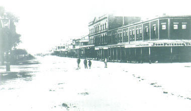
Photograph - PALL MALL, 1876
Black and White Photo of Pall Mall, Building at the Corner of Pall Mall and Mitchell Streets has the Sign 'John Paterson' and 'John Paterson Tailor', 4 small children are at the centre of the photo, Beehive Building, Shamrock Building in the distance, Markings on rear of the photo are 'Pall Mall', 'Holterman Collection 1876'buildings, commercial, pall mall, john paterson, beehive, shamrock -
 Bendigo Historical Society Inc.
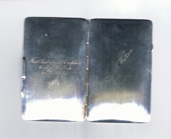
Memorabilia - BASIL WATSON COLLECTION: STERLING SILVER CARD CASE, 1917
Sterling silver card case (B Watson) - hinged with single brass leaf insider engraved with details of Watson's flights and achievements in Australia - destinations,distance, time, date inscribed on inside of case.. On front ''Basil G. Watson''; on back ''First Australian to Loop the Loop in Australia'' (engraved inscriptions)person, individual, basil watson -
 El Dorado Museum Association Inc.
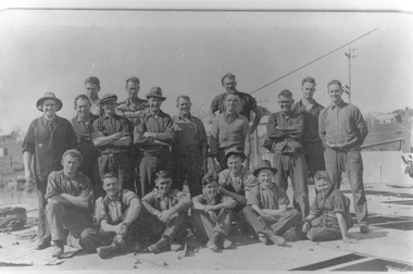
Photograph - Digital Image
Dredge Workers, c. late 1930s. Cock's El Dorado Gold & Tin Mining Dredge operated between 1936 and 1954. At the time of its construction, the dredge was the largest in the Commonwealth, producing 2,198 kg of gold.mining, gold, gold mining, dredge, cock's el dorado dredge, men, miners, el dorado, eldorado -
 Stawell Historical Society Inc
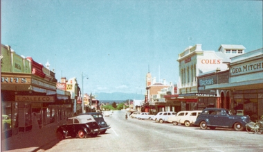
Photograph, Main Street Stawell looking West with Geo. Mitchell shop on the right c 1955 -- Coloured
Coloured photo c 1955 Main Street Scene looking West. Geo Mitchell Draper on right with Coles and Macrows. On the left E. Dale & Co. shop sign is visible. Either side of the street has cars parked at an angle with a soft canopy car parked on the left side.Colour photograph looking down Main St Stawell with the Grampians in the distance c 1955. This coloured photo has shops either side in view and cars parked at an angle along the street. Coles, Macrows and Geo. Mitchell shops are on the right and E. Dale & Co shop sigh is visible on the left.stawell business streetscape -
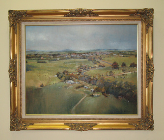 South Gippsland Shire Council
Painting. Oil, Leongatha Landscape
Framed oil painting titled: "Leongatha Landscape" painted by Harris Smith. Features scene of farming property in the foreground and township of Leongatha in the distance. Rolling hills, flora, buildings and sky. Gold decorative frame with cream textured vinyl window mount. Painted in shades of browns, greens, blues and yellows. -
 Kew Historical Society Inc
Photograph - High Street looking north to Burke Road, 1907-08
While a number of subdivisions of what was to become Kew East occurred in the 1880s, such as the 'Mount Pleasant Estate' (1888) and 'Monterey Estate' (1888), Glynn's Lot 91 remained open farmland until the Harp Estate (1912) was sold, hence the undeveloped nature of the view in 1907-8.A rare image of the open farmland in the eastern part of Kew looking towards Burke Road in 1907-8.Damaged, and very rare, black & white photograph of what was to become the suburb of East Kew, taken by a member of the Bennett family in 1907-8. The photograph is taken from the Harp of Erin Hotel showing, apart from a building on the left (no longer extant), fenced open farmland stretching into the far distance.HIGH ST LOOKING NOTRTH TO BURKE RD FROM HARP / EDWD GLYNN'S LOT 91 FROM 1851 / GIFT FROM BENNETT FAMILY 22 HARP RD EAST KEW 1980 / 1907-8harp of erin, high street -- east kew (vic), harp estate -
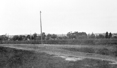 Surrey Hills Historical Society Collection
Photograph, Corner of Braemar and Melrose Streets, Box Hill North
Reproduced by permission of Mr John Arnold from his book: "The Riversdale Golf Club - a history, 1892-1977." Copyright to book: Riversdale Golf Club. Surrey Hills Golf Club operated from 1892-1908 then moved and became Riversdale Golf Club. The game was played across paddocks from Trafalgar Street, Mont Albert to Whitehorse Road and down Victoria Crescent to where Box Hill TAFE is now located in Elgar Road. There were problems with cows eating the tee flags! The clubhouse still exists as 30 Trafalgar Street.Black and white panoramic photo taken from the corner of Braemar and Melrose Streets, Box Hill North. There is a large area of ground in the front. A fence and hedge traverse the photo in the middle distance in front of which is a tall light pole. Behind the hedge mature trees and houses can be made out.Caption: "Bottom: The same view today taken from the corner of Braemar and Melrose Streets, Box Hill North, or, from the position of the threesome to the left in the above photograph." + in grey lead pencil in Jocelyn Hall's hand (No 290)sports grounds, surrey hills golf club, riversdale golf club, melrose street, braemar street, surrey hills, john arnold -
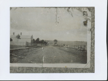
 Tarnagulla History Archive
Photograph looking up Commercial Road, Tarnagulla, Looking up Commercial Road, Tarnagulla, c.1960s
Murray Comrie Collection. Original print.Monochrome photograph. View looking up Commercial Road, Tarnagulla, from the Poverty Street intersection. Street deserted - no people or vehicles visible. Building with text 'Williams & Clouston's' visible at far right. Willersdorf;s store opposite, and the Borough Council Chambers can vaguely be seen in the left distance. tarnagulla, businesses, commercial road -
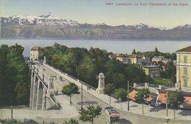 Bendigo Historical Society Inc.
Postcard - ROY AND DORIS KELLY COLLECTION: LAUSANNE. LE PONT CHAUDERON ET LES ALPES, 1900-1920
Postcard, coloured photo of Lausanne showing the Chauderon Bridge over the Flon Valley with the Swiss Alps in the background. Light pedestrian traffic over the bridge with a tram and shops in foreground. Lake Lausanne in the middle distance. Printed on the back 'Edition Art. Perrochet & David, La Chaux-de-Fonfs-Lausanne'postcard, photograph, postcard, lausanne, switzerland, chauderon bridge, swiss alps -
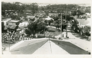 Lakes Entrance Historical Society
Postcard - Whiter's Camp Park, 1935
Black and white postcard showing an extensive portion of Whiter's Camp Park, taken from the elevated tankstand looking south to the main entrance. Lake and hummocks in distance. Cabin, tents and petrol bowser as well as a crowd of people in image and roof of rotunda directly under photographer. Lakes Entrance Victoriatourism, camping, caravan parks -
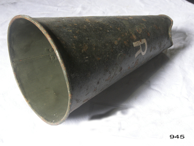 Flagstaff Hill Maritime Museum and Village
Functional object - Megaphone, 1920-1940
A megaphone or loudhailer is usually portable or hand-held, the cone-shaped acoustic horn used to amplify a person's voice or other sounds and direct it in a given direction. Used to communicate with others over distances. In Greek mythology, "Stentor" was a Greek herald during the Trojan War. His name has given rise to the adjective "stentorian", meaning loud-voiced, for which he was famous. The large funnel-shaped device is made of painted metal that is riveted together. It has no metal mouthpiece at the narrow end but rather a larger opening that is associated with a movie directors megaphone. It could also be used in a maritime situation or anywhere a person needs to amplify their voice to give directions to others over a distance. The Megaphone has significance for its provenance and historic value, and also as a relatively rare item of equipment once used worldwide in not only marine situations, or light house stations as well as many other differing types of applications where a person voice was needed to be amplified when communicating with others.Pressed Metal megaphone or loud hailer, with rolled wire rims, folded seam and riveted handle painted green and marked "R" "R"warrnambool, flagstaff-hill, flagstaff-hill-maritime-museum, maritime-museum, shipwreck-coast, flagstaff-hill-maritime-village, megaphone, loud hailer, directors megaphone, communication device -
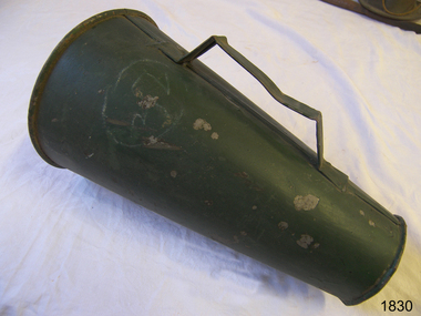 Flagstaff Hill Maritime Museum and Village
Functional object - Megaphone, 1920-1940
A megaphone or loudhailer is usually portable or hand-held, the cone-shaped acoustic horn used to amplify a person's voice or other sounds and direct it in a given direction. Used to communicate with others over distances. In Greek mythology, "Stentor" was a Greek herald during the Trojan War. His name has given rise to the adjective "stentorian", meaning loud-voiced, for which he was famous. The large funnel-shaped device is made of painted metal that is riveted together. It has no metal mouthpiece at the narrow end but rather a larger opening that is associated with a movie directors megaphone. It could also be used in a maritime situation or anywhere a person needs to amplify their voice to give directions to others over a distance. The Megaphone has significance for its provenance and historic value, and also as a relatively rare item of equipment once used worldwide in not only marine situations, or light house stations as well as many other differing types of applications where a person voice was needed to be amplified when communicating with others.Megaphone or loud hailer, metal painted green with handle and a large indented mouth piece. Nonewarrnambool, flagstaff-hill, flagstaff-hill-maritime-museum, maritime-museum, shipwreck-coast, flagstaff-hill-maritime-village, megaphone, loud hailer, directors megaphone, communication device -
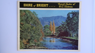 Kiewa Valley Historical Society
Brochure - Shire of Bright, Shire of Bright Tourist Centre of N.E. Victoria, Pre 1966
Bright and the surrounding towns were developing a large tourism industry which the Shire of Bright continues to promote, encouraging tourists to visit throughout the year. This high quality brochure has magnificent photos with a map showing the area and the distance (in miles) from the centre - the township of Bright.This brochure is promoting the Shire of Bright encouraging tourism in the area. This is important for the Shire as tourism is the main industry for the Shire. It is interesting to see how tourism has changed (or not) in the area.14 pages on glossy paper including colored and black and white photos. The front cover has the title at the top with yellow print on black background. Below the title is a large colored photo of a river, autumn trees and mountain. The back cover is a large colored photo of a man amongst the snow gums in the snow. The towns covered are Bright, Wandiligong, Eurobin, Mt Buffalo, McKay Creek Power Station, The Kiewa Hydro Electric Scheme, Mt Beauty, Kiewa, Bogong including tourist destinations in these areas and their surrounds.tourism; mt beauty; the kiewa valley; bright shire -
 Bialik College
Document (item) - COVID-Safe Plans, 2020-2022, 2020-2021
Plans outlining the protocols introduced by the school, creche and kindergarten to prevent the spread of coronavirus, including hygiene practices, social distancing and testing expectations, parent access, and advice about talking to children about COVID-19. Please contact [email protected] to request access to this record.covid, policies, 2020s -
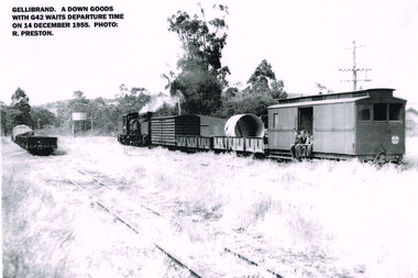 Otway Districts Historical Society
Photograph, R. Preston, Gellibrand: DOWN goods with G42 awaiting departure, 14 December 1955
A DOWN goods train consisting of a G42 locomotive, a louvre van, two NQ trucks and a guard's van awaits departure from Gellibrand. Three youths are seated in the doorway of the guard' van. On the near track further NQ trucks are parked. A water tank appears in the distance.A DOWN goods train with locomotive G42 awaits departure time from Gellibrand on 14 December 1955. B/W.gellibrand; railways; locomotive g42; louvre van; nq trucks; guard's van; water tank; -
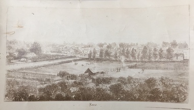 Kew Historical Society Inc
Print, Jenny Rudolph, Kew
The point of view of the artist is looking towards Kew from the vicinity of Xavier College. The paddocks in the foreground are bordered by Wellington Street. In the distance the towers of the asylum can be see, further narrowing the date to after 1870s. The work exists in a number of original versions including a colour print.Kew, ca. 1870 - ca. 1880. Reproduction of a book plate from an original wood engraving, of an elevated view of trees and paddocks with a town in the background. The illustration is signed R. JENNY Sc. [Rudolph Jenny 1827-1905, lithographer.] A version from which this reproduction may have been made was donated to the State Library of Victoria by the National Trust, Victoria in 1985. kew (victoria), wellington street -- kew (vic.) -
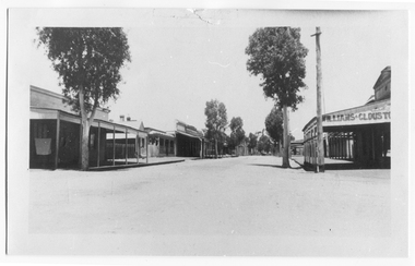
 Stawell Historical Society Inc
Photograph, Main Street looking west from Bull & Mouth Hotel with Named Shops in the 2nd Photo -- 2 Photos c1907/08
Main Street Stawell c1907 Left is Bull & Mouth Hotel, Playfords, Whiteside & Co Taylors Carters Boot shop. On right Rotunda in distance, T Browns Furniture, George Mitchell, Norman A Harding, W.C. Barker Picture framing. Rose Series P 2725The Rose Series. P. 2725 Main Street, Stawell, Victoria stawell streetscape -
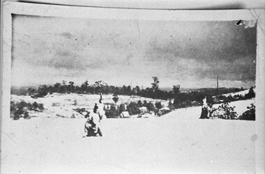
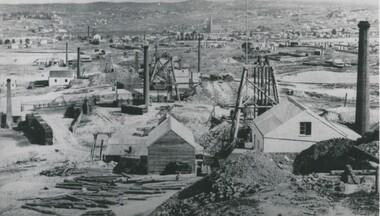 Bendigo Historical Society Inc.
Photograph - MINING AREA VIEW FROM NEW CHUM HILL, 1875
Black and white photograph. View overlooking mining area from New Chum Hill in the early 1870's showing four poppet legs and at least nine chimneys (small chimneys and poppets at L distance). Golden Square Methodist Church, Laurel Street C distance. Inscriptions on back: 'MNG 21' and round 'Historical society of Victoria, Bendigo Branch' stamp. Typed on front: 'Looking South from New Chum Hill in early 1870's. The rich 'Lazarus New Chum' in foreground. Other rich New Chum Mines in background'. History of object: Previous Acc. No. 'MNG 21', James Lerk, 26.11.1999, N.J. Caire, photograph 1875'.N.J. Caireplace, mining site, see also 2001.004.01 -
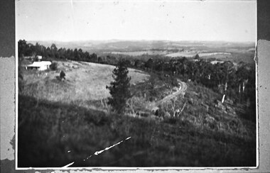
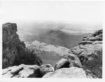 Halls Gap & Grampians Historical Society
Photograph, C 1960s
The valley is known as Fyans Valley and the township of Halls Gap. Photo is typical of those taken by the Forestry Commission (Vic) during the 1960s.Photo shows two rocky outcrops in the foreground framing a valley in the distance below. A partial view of a mountain range flanks the valley. Plains of trees and open fields, and also a lake, can be seen beyond the mountain range. Within the valley in the middle of the photo buildings, roads and cleared land can be seen.scenery, fyans valley -
 Federation University Historical Collection
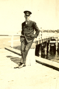
Photograph - Black and White, Frank Wright at a pier, 1920s
Frank Wright was a renown resident of Smeaton, where he was born on 2 August 1901. He lived at Laura Villa, and attended Smeaton State School. His father William was a gold miner and his mother's name was Sarah. Their family won many singing and instrumental awards. Frank was tutored by Percy Code and was awarded a gold medal for the highest marks in the ALCM examinations in the British Colonies at the age of seventeen years. He became the Australian Open Cornet Champion by the age of eighteen. A year later, Frank conducted the City of Ballarat Band, and later the Ballarat Soldiers’ Memorial Band. He formed the Frank Wright Frisco Band and Frank Wright and his Coliseum Orchestra. These bands won many South Street awards, and Frank as conductor won many awards in the Australian Band Championship contest. In 1933 Frank Wright sailed to England to conduct the famous St Hilda’s Band and was later appointed Musical Director of the London County Council, where he organized many amazing concerts in parks, in and around the London district. He was made Professor of Brass and Military Band Scoring and conducted at the Guildhall of Music and Drama. Frank was often invited to adjudicate Brass Band Championships around Europe, in Australia, including South Street and in New Zealand. The Frank Wright Medal at the Royal South Street competition is awarded to an individual recognized as making an outstanding contribution to brass music in Australia.Black and white photograph of a young man with his hands in his pockets, leaning against the bollard of a pier. The man is dressed in the Ballarat City Band uniform and cap. Behind him the pier extends into the water and in the distance on the far side of the water can be seen a headland with houses and buildings. The man is Frank Wright.frank wright, ballarat city band, pier, conductor, brass band -
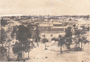
 Bendigo Historical Society Inc.
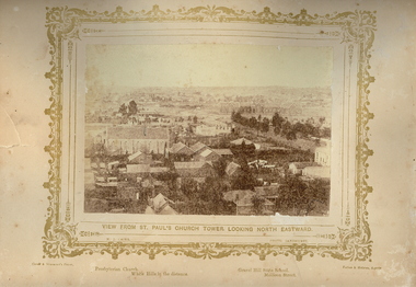
Photograph - VIEWS OF BENDIGO: BENDIGO N.E. FROM ST PAUL'S CHURCH, c.1870's
Sepia photograph 'View of Bendigo No. 48'. Depicts a view of Bendigo City from St Paul's Church Tower. Inscriptions: top margin, 'View of Bendigo, No. 48', 'Presbyterian Church, White Hills in the distance', 'Gravel Hill State School, Mollison Street' 'MP 163'. (Three copies) Nicholas CaireN J Caireplace, streetscape, bendigo -
 Bendigo Historical Society Inc.
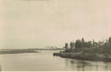
Postcard - ACC LOCK COLLECTION: B&W PHOTO OF A RIVER, EGYPT, POSTCARD, 1914-1918
Poastcard, WW1, B&W photo of one of the river Nile tributaries. Trees on the right side bank and palm trees in the distance beyond a small craft on the river. Handwritten in ink on the back - North of one of the tributaries of the Nile. Egypt Dec '15 Also handwritten in pencil - more of right side to appearpostcard, postcard, ww1, egypt, river nile -
 Bendigo Historical Society Inc.
Photograph - HARRY BIGGS COLLECTION: LOOKING SOUTH AT EAGLEHAWK, c1875
Photograph. Harry Biggs Collection. 3 black & white photos looking south at Eaglehawk. Circa 1875. Photographer Caire. An overview of the City of Eaglehawk. Town Hall Hotel can be seen in the distance. The word Drapers is to the left. Trees are in the foreground. Eaglehawk State School is on the skyline (tall building with the bell tower).Caire.photograph, streetscape, eaglehawk, harry biggs collection, looking south at eaglehawk, eaglehawk state school, town hall hotel, eaglehawk town hall, eaglehawk post office -
 Southern Sherbrooke Historical Society Inc.
Photograph - Puffing Billy line near The Tanks
B&W photo of the Puffing Billy line near The Tanks below Glen Park Farm. On the left is the house of the Dunham family, with shedding in the background. The land slopes down to the track then falls quite steeply away to a treed area. In the distance can be seen land which is now part of Cardinia Reservoir. -
 Southern Sherbrooke Historical Society Inc.
Photograph - A little bit of “Aura” snow
Photograph taken from the hill to the north of Menzies Creek. There has been a heavy snowfall and dark clouds are in the sky. In the centre of the photo St Cuthberts Church is visible in the distance, with houses beyond it. Buildings are also visible in the vicinity of the railway station. An indistinct object in the foreground of the photo may be two children playing. -
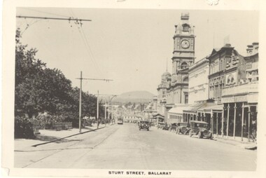 Ballarat Tramway Museum
Photograph - Digital image, 1930
Yields information the buildings, buildings and scene in Sturt St looking East from Doveton St.Digital image from the Wal Jack Ballarat Album of a postcard - titled "Sturt St Ballarat", looking east along the south side of Sturt St from Dawson St. Tram in the far distance. Has a number of motor vehicles in the photograph. No details of the manufacturer on the back of the photograph - see image i2.trams, tramways, esco, sturt st, dawson st -
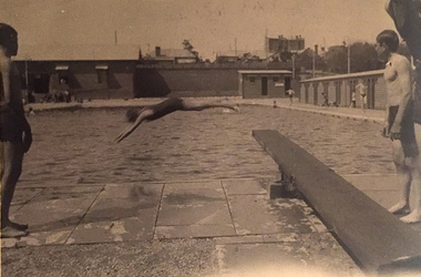 Kew Historical Society Inc
Photograph, Kew Municipal Baths, 1930s
W.D. Vaughan in 'Kew's Civic Century' (1960) has a chapter (XXII, pp.103-105) on the Kew Swimming Pool (aka Kew Baths). In the chapter he recounts debate in Council from 1912 about the need for a swimming pool. The first concrete step toward achieving this occurred in 1914 when Council purchased the Tramways Sheds on the corner of High and Disraeli Streets in 1914. Further adjoining land in High Street was compulsorily acquired in 1923. The final plans were accepted in 1925 and following public tender, Messrs. Weavill and Keast were appointed to construct the pool at a cost of 5,418/9/-. The baths were formally opened on 18 November 1925 by George Ramsay, Mayor of Kew. (The Kew Swimming Club was founded in the same year.) Vaughan notes that "mixed bathing was not permitted at the Kew Baths until January, 1928, when it was allowed every evening (except Sundays) and Friday afternoons. A few years later these restrictions were removed altogether".Small B&W photograph of two boys standing beside a diving board at the old Kew Swimming Pool while in the distance a woman dives into the pool. The photograph can be dated to the years 1929-33, as the wooden grandstand was not erected until 1929 and it was before a new high swimming platform was erected in 1933."Old Swimming Pool Kew. D4. 92"kew swimming pool - kew (vic), sport and recreation - kew (vic), kew baths - kew (vic), mayors of kew - cr. george ramsay - kew (vic), kew swimming club -
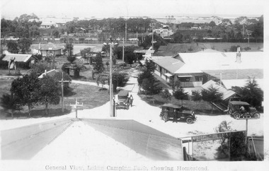 Lakes Entrance Historical Society
Postcard, 1928c
Black and white photograph of Whiters Park, showing residence and office, gardens, tennis court, early model car by the petrol bowser, electric lights on tall poles. Opposite park entry is Aults Motor Engineer, scattered cottages. In distance is Cunninghame Arm, sand hummocks and ocean. Lakes Entrance Victoriaresort, township, transport, recreation -
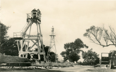 Lakes Entrance Historical Society
Postcard - Lookout tower Jemmy's Point, 1940
Black and white small format postcard of the timber observation lookout at Jemmys Point, Lakes Entrance, Victoria, showing the updated and safer steps from ground to observation deck, with fenced landing at halfway point. Old log and seat still nearby, signal light on steel tower a short distance away.historic sites, navigation, fences -
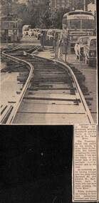 Melbourne Tram Museum
Newspaper, The Age, track reconstruction work in Bridge Road Richmond, c1974
Newspaper clipping from an undated Melbourne page, about track reconstruction work in Bridge Road Richmond, between Burnley St and the Yarra River. Shows the temporary trackwork slew along the road with a long line of cars alongside. In the distance is a tram showing Kew Depot, route 23. Work c1974.trams, tramways, bridge rd, trackwork, route 23, temporary track