Showing 4285 items matching "forests"
-
 Southern Sherbrooke Historical Society Inc.
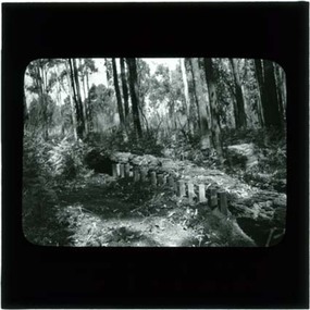
Photograph, Termite fence line test, Belgrave
Black and white photo, c.1923-32, taken from a lantern slide, showing a termite fence line test along a termite-infested log. Log is surrounded by open forest. -
 Southern Sherbrooke Historical Society Inc.
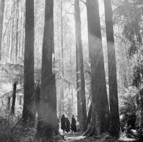
Photograph, Sherbrooke Forest 1968
Black and white photo showing a group of four or more people walking in Sherbrooke Forest between mountain ash trees. Treeferns are also visible. Created by the Australian News and Information Bureau. -
 Otway Districts Historical Society
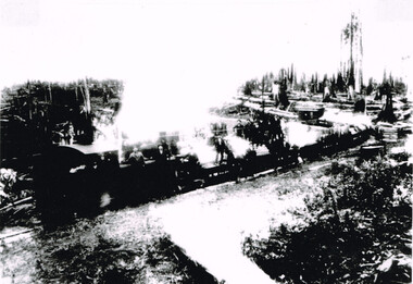
Photograph, Knox Collection, Beech Forest: train hauling timber, 1912
B/W/ "NA" class locomotive, NQR wagons and NC guard's van hauling timber near Gardner's property in Beech Forest in 1912. Note the workmen clustered on the engine and wagons.beech forest; railway; -
 Otway Districts Historical Society
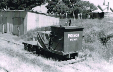
Photograph, R. Preston, Beech Forest: poison trolley, 1958, 8 January 1958
B/W. Poison trolley NG No.1 on the Gang Shed siding at Beech Forest on 8 January 1958. The Gang Shed is shown. In the right background the Otway Shire Secretary's house.beech forest; railways; -
 Otway Districts Historical Society
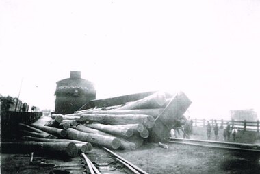
Photograph, Derailment at Beech Forest, c.1950, c.1950
B/W. In c.1950 in Beech Forest an NQR wagon load of wood is derailed while changing tracks behind an NA-class locomotive. People are watching. On the left are NQR wagons.beech forest; railways; -
 Bendigo Historical Society Inc.
Slide - DIGGERS & MINING: THE DIGGINGS - THE DIGGERS
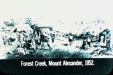
Diggers & Mining: The Digging - The Diggers. Slide depicts areas of Forest Creek, Mount Alexander, 1852. Timber Buildings and miners. Markings: 15 994.LIF:6. Used as a teaching aid.hanimounteducation, tertiary, goldfields -
 Tennis Australia
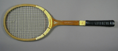
Racquet, Circa 1950
A Forest Hills 7-Ply tennis racquet, with ribbon whipping around shoulders and shaft. Materials: Wood, Nylon, Ink, Glue, Lacquer, Metal, Ribbon, Leather, Adhesive tape, Painttennis -
 Lakes Entrance Historical Society
Photograph, 1999
Also three other photographs taken at siding of Colquhoun Railway Siding, donated by Jan McDougall in 2000Colour photograph taken at the site of the previous Colquhoun Railway siding, showing the position of the dismantled track and some sleeper remains, surrounded by young growth forest and scrub. East Gippsland Victoriahistoric site, railway -
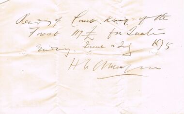 Bendigo Historical Society Inc.
Document - ANCIENT ORDER OF FORESTERS NO 3770 COLLECTION: RECEIPT
Receipt written on a piece of cream paper from H. L. Atkinson saying he received £117 from Court King of the Forest. June & July. Signed H L Atkinson.societies, aof, correspondence, ancient order of foresters no 3770 collection, - receipt, court king of the forest, h l atkinson -
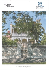 Bendigo Historical Society Inc.
Document - BROCHURE 57 FOREST STREET, BENDIGO - ILLIRA
Coloured brochure for real estate agents McKean McGregor and First National featuring 57 Forest Street, Bendigo. Photos of the exterior and interior plus floor plan. The name of the house ''Illira''buildings, house, illira -
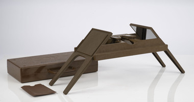
 Creswick Campus Historical Collection - University of Melbourne
Equipment, Spiegel Relaskop
Instrument. Relascope. The relascope, invented by Walter Bitterlich, is a multi-use instrument for forest inventory. It is primarily used to find height of a tree, basal area of a tree and diameter of a tree anywhere along the bole. This instrument is used mostly for applications involving variable radius sample plots in a forest survey.Equipment32485 -
 Department of Energy, Environment and Climate Action
Foldable Stereoscope
This stereoscope was used to view a pair of separate and overlapping aerial photos as a single three-dimensional image. This smaller foldable unit could be easily used in the field but larger, mirror stereoscope was used in offices. The aerial images were used to map forest types, timber stands, new roads and tracks, firebreaks, boundaries of timber harvesting, plantations, bushfires, insect and disease attack and so on In 1928, the Forests Commission undertook its first major aerial photography project over 15,000 acres of forest which is said to be the first of its kind in Australia. During the Second World War, large areas of Victoria were photographed by RAAF and used to produce orthophoto maps. By 1945 aerial photography of 13,000 square miles (3.4 M ha) was completed, including much of the inaccessible eastern forests. The Forests Commission started developing its own small format photography in the early 1970s. Simple, cheap and rapid methods of obtaining photographs using 70mm and 35mm cameras were developedFoldable plastic stereoscope in box Benallaforests commission victoria (fcv), surveying, forest measurement -
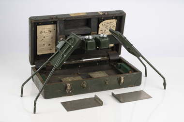 Department of Energy, Environment and Climate Action
Stereoscope
This stereoscope was used to view a pair of separate and overlapping aerial photos as a single three-dimensional image. Smaller units and could be easily used in the field but this larger, mirror stereoscope was used in offices. The aerial images were used to map forest types, timber stands, new roads and tracks, firebreaks, boundaries of timber harvesting, plantations, bushfires, insect and disease attack and so on In 1928, the Forests Commission undertook its first major aerial photography project over 15,000 acres of forest which is said to be the first of its kind in Australia. During the Second World War, large areas of Victoria were photographed by RAAF and used to produce orthophoto maps. By 1945 aerial photography of 13,000 square miles (3.4 M ha) was completed, including much of the inaccessible eastern forests. The Forests Commission started developing its own small format photography in the early 1970s. Simple, cheap and rapid methods of obtaining photographs using 70mm and 35mm cameras were developedFoldable metal stereoscope in wooden box with mirror covers Ex Dept of Defenceforests commission victoria (fcv), surveying, forest measurement -
 Ballan Shire Historical Society
Map - Map. Korweinguboora, Department of Lands and Survey, Korweinguboora. Counties of Talbot and Grant
A map of the Korweinguboora area showing roads, forests, railway lines and properties with the owners names.The inclusion of the names of landowners is of significance and value to historians.A map of the Korweinguboora area showing land subdivisions and names of owners and other physical features. There is a scale in chains. No date is certain but it could be 1902. The map has been repaired with sellotape.There are various pencil annotations but the are difficult to read.talbot, moorarbool west, wombat, bullarto, korweinguboora, moorarbool east, dean, wombat state forest, barkstead -
 Greensborough Historical Society
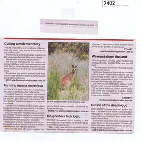
Newspaper Clipping, Culling a mob mentality, 28/10/2015
Diamond Valley Leader Letters to the Editor discuss the issue of kangaroos at Gresswell Forest Reserve.News clipping, black text, colour image.kangaroos, gresswell forest reserve -
Creswick Campus Historical Collection - University of Melbourne
Document, The Future of Forestry and Forest Science Conference, 2010
The Future of Forestry and Forest Science Conference, September 30 - October 2. Delegate handbookBook -
Creswick Campus Historical Collection - University of Melbourne
Photograph - Photographs Tasmanian forestry and forest landscapes
Tasmanian forestry and forest landscape photographs taken by Dan Kitchener, New Norfolk TasmaniaPhotographs -
 Creswick Campus Historical Collection - University of Melbourne
Photograph - Photographs of forests and plantations in England, Wales, France and Scotland, 1935
Photographs of forests and plantations in England, Wales, France and Scotland with notes about each photographPhotographs -
Stawell Historical Society Inc
Book - Report, Grampians National Park Draft Management Plan, 1985
For Public comment to National Park Service, Victoria. A Division of the department of Conservation, Forest and LandsSoft Cover with B/W Photo of aerial view of ranges of Grampians. Black taped Spine binding.$5 Barry Clugston -
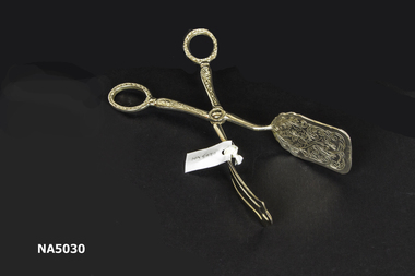 Whitehorse Historical Society Inc.
Domestic object - Silver plate cake server, 1934
Owned by donor Pat Richardson's mother Vera McDowell(nee Edwards) of Forest Hill.Silver plated cake server. Scissor action, flat spoon with three pronged top piece. Fine engraving.food serving, table cutlery -
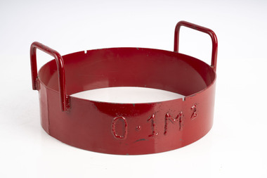 Department of Energy, Environment and Climate Action
Fuel sampling ring
Used to sample fine fuels on the forest floor. The ring was pushed into the litter to sample 0.1m2Heavy metal ring with sharpened bottom edgeforests commission victoria (fcv), bushfire, forest measurement -
 Whitehorse Historical Society Inc.
Article, Farewell Forest Hill Rotary, Sep 2024
After 49 years, the Rotary Club of Forest Hill handed back its charter on 30/06/2024non-fictionAfter 49 years, the Rotary Club of Forest Hill handed back its charter on 30/06/2024rotary club of forest hill, service clubs -
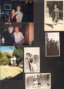 Bendigo Historical Society Inc.
Photograph - POWELL COLLECTION: VARIOUS PHOTOGRAPHS
COLLECTION OF PHOTOGRAPHS. Comprises 8 B&W photos of individuals or groups (various era) with no names provided; 4 colour photographs of people (couples) with no names provided; 2 B&W photographs with name identification on back - Russell January 1942; Russell & Audrey with Bridesmaids & Best Man Shirley's husband - Best Man Jack's daughter - small bridesmaid on left; one B&W? ( Polaroid) photograph of building - on reverse - Campbell Connelly, Bendigo (cnr. Forest St and High St). This photo shows the current building (2015 Chinese restaurant) with adjoining builiding in Forest St having Taubman's advertisement and corner building having a sign pointing up Forest St to the City Centre Motel. -
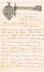 Bendigo Historical Society Inc.
Document - ANCIENT ORDER OF FORESTERS NO. 3770 COLLECTION: CORRESPONDENCE
Letter, with printed letterhead and emblem, to the Secretary of Court King of the Forest from the Secretary of Court Inglewood No 3985, dated Nov 6th 1876. Letter mentions a member who has gone off New Zealand and left his wife and daughter in Nettle Street, Sandhurst. He would like his name added to Court King of the Forest Surgeons list. Also mentions Surgeons fees on account of Bros Josiah Smith and le Huray.societies, aof, correspondence, ancient order of foresters no. 3770 collection - correspondence, court inglewood, h w brett, josiah smith, le huray, court king of the forest -
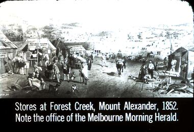 Bendigo Historical Society Inc.
Slide - DIGGERS & MINING. STORES AT THE DIGGINGS, c1852
Diggers & Mining. Stores at the diggings. Stores at Forest Creek, Mount Alexander, 1852. Note the office of the Melbourne Morning Herald. Slide show the busy area of Forest Creek stores. From left to right the signs that can be read: ? Argus Office, Gold bought and sold here, Bryce Ross's Newspaper and General Agency Office, STG '52 marked at bottom left corner of picture. Markings: 7 994.LIF. 5. Used as a teaching aid.hanimounteducation, tertiary, goldfields -
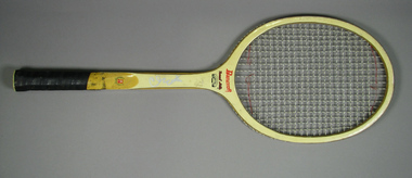 Tennis Australia
Racquet, Circa 1975
A Bancroft Forest Hills tennis racquet, with bamboo laminated frame, and patterned leather handle. Bancroft logo features across base of head. Throat features model name, and linear decal image of Forest Hills main court. Wreathed 'B' trademark on lower shaft, and red 'B' trademark on butt cap. Illegible autograph features along shaft on obverse. Materials: Wood, Nylon, Leather, Glue, Lacquer, Metal, Ink, Plastic, Painttennis -
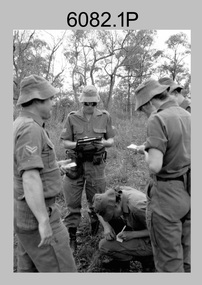 Bendigo Military Museum
Photograph - Army Survey Regiment - Regimental Training Navigation Exercise, 1985
This is a set of 16 photographs of Army Survey Regiment personnel undertaking a non-tactical navigation exercise, part of the field phase of regimental training in the Wellsford Forest, Bendigo 1985. This was one of the six regimental training objectives outlined in the administrative instruction – Exercise “City Soldier” accompanying these photos. The other objectives were SLR rifle and M30 grenade handling revision, and first aid at Fortuna; RATEL at Wellsford Forest and rifle shooting at Wellsford Rifle Range. Personnel from Air Survey, Cartographic, Lithographic and Headquarters Squadrons were reallocated to four training platoons for one week from 7th to 11th October 1985.This is a set of 16 photographs of Army Survey Regiment personnel undertaking a navigation exercise in the Wellford Forest, Bendigo 1985. Black & white photos .1P to .10P are printed on photographic paper and scanned at 300 dpi. Photos .11P to .16P are on 35mm negative film and scanned at 96 dpi. They are part of the Army Survey Regiment’s Collection. .1) - Photo, black & white, 1985, L to R: CPL Mick Minchin, SGT Alan Staley, CPL Megan (McBurney) Reynolds SPR Wendy (Leitinger) McCarthy. .2) - Photo, black & white, 1985, L to R: unidentified, SPR Wendy (Leitinger) McCarthy, CPL Megan (McBurney) Reynolds, unidentified, SGT Alan Staley, SPR Dave Lawler. .3) - Photo, black & white, 1985, L to R: CPL Greg Honan, CPL Grant McGuinness, SPR Leah (Hoffman) Peppler, CPL Ken Peters, SSGT Ian ‘Rock’ Thistleton, SSGT Kevin ‘Spook’ Kennedy. .4) - Photo, black & white, 1985, unidentified personnel. .5) - Photo, black & white, 1985, L to R: CPL Peter ‘Spoon’ Lefel, unidentified, CPL Mick ‘Buddha’ Ellis. .6) - Photo, black & white, 1985, L to R: SSGT Harald Mai, unidentified. .7) - Photo, black & white, 1985, unidentified personnel. .8) - Photo, black & white, 1985, unidentified personnel. .9) - Photo, black & white, 1985, WO1 Dick Manley. .10) - Photo, black & white, 1985, L to R: LT Brenton MacDonald, LT Kathie Ryan, WO1 Brian Mead. .11) - Photo, black & white, 1985, L to R: LT Carol Dunstan, unidentified, CPL John Reid. .12) - Photo, black & white, 1985, L to R: WO1 Dick Manley, unidentified, LT Carol Dunstan. .13) - Photo, black & white, 1985, L to R: unidentified (x2), WO1 Dick Manley. .14) - Photo, black & white, 1985, LT Brenton McDonald. .15) - Photo, black & white, 1985, L to R: CPL Megan (McBurney) Reynolds, SPR Wendy (Leitinger) McCarthy, CPL Mick Minchin. .16) - Photo, black & white, 1985, L to R: SPR Wendy (Leitinger) McCarthy, CPL Mick Minchin..1P to .16P – No personnel are identified.royal australian survey corps, rasvy, army survey regiment, army svy regt, fortuna, asr -
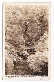 Marysville & District Historical Society
Postcard (item) - Black and white postcard, Rose Stereograph Company, Talbot Drive, Marysville, Vic. No. 5. Beech Grove, 1913-1967
A postcard in a series produced by the Rose Stereograph Company in Victoria, Australia as a souvenir of Marysville.A black and white photograph taken along Lady Talbot Drive, Marysville, Victoria, of the area known as the Beech Grove. The Beeches Rainforest Walk is a loop that starts at Taggerty Cascades before winding through Myrtle Beech and Mountain Ash woodland and is one of the many walking tracks in and around Marysville. It is accessible from Lady Talbot Drive which is a 24 kilometer scenic rainforest car journey which passes a number of walks and waterfalls in the Yarra Ranges National Park. Lady Talbot Drive is named after Lady Sarah Elizabeth, the wife of Sir Reginald Talbot, who was the Governor of Victoria from 25th April, 1904 to 6th July 1908. This postcard was produced by the Rose Stereograph Company as a souvenir of Marysville.POST CARD The "Rose" Set/ De Luxe A Real Photograph/ Produced in Australia Published by the Rose Stereograph Co./ Armadale, Victoria. This is just to remind you of/ Marysville - I am spending the/ weekend up here & thoroughly/ enjoying it./ Love to all of you L. McIver All best honey + thanks for/ a lovely day E. + P. F.talbot drive, marysville, victoria, beech grove, p. 2310, rose series postcard, postcard, souvenir, beeches rainforest walk, sarah elizabeth talbot, sir reginald talbot, mountain ash, myrtle beech -
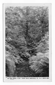 Marysville & District Historical Society
Postcard (item) - Black and white postcard, Rose Stereograph Company, Talbot Drive, Marysville, Vic. No. 5, Beech Grov, 1913-1967
A postcard in a series produced by the Rose Stereograph Company in Victoria, Australia as a souvenir of Marysville.A black and white photograph taken along Lady Talbot Drive, Marysville, Victoria, of the area known as the Beech Grove. The Beeches Rainforest Walk is a loop that starts at Taggerty Cascades before winding through Myrtle Beech and Mountain Ash woodland and is one of the many walking tracks in and around Marysville. It is accessible from Lady Talbot Drive which is a 24 kilometer scenic rainforest car journey which passes a number of walks and waterfalls in the Yarra Ranges National Park. Lady Talbot Drive is named after Lady Sarah Elizabeth, the wife of Sir Reginald Talbot, who was the Governor of Victoria from 25th April, 1904 to 6th July 1908. This postcard was produced by the Rose Stereograph Company as a souvenir of Marysville.POST CARD The "Rose" Series/De Luxe A Real Photograph/ Produced in Australia Published by the Rose Stereograph Co./ Armadale, Victoria. MATHESONtalbot drive, marysville, victoria, beech grove, p. 2310, rose series postcard, postcard, souvenir, beeches rainforest walk, sarah elizabeth talbot, sir reginald talbot, mountain ash, myrtle beech -
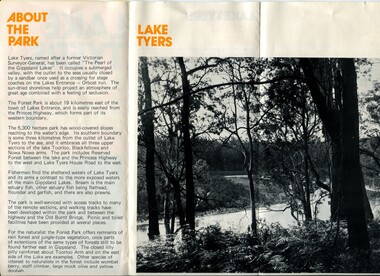 Orbost & District Historical Society
pamphlet, Lake Tyers Forest Park, 1960's
This pamphlet would have been produced as a tourist guide to East Gippsland.This item is a useful reference tool.A three fold glossy, pamphlet titled"Lake Tyers Forest Park". It contains information, a map and black / white photographs of Lake Tyers Park. Print colours are brown, white, yellow and black.pamphlet lake tyers-forest-park