Showing 1104 items matching "information map"
-
 Melbourne Tram Museum
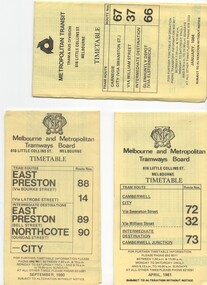
Document - Timetable/s, Melbourne & Metropolitan Tramways Board (MMTB), "MMTB Tram Timetables", 1980 - 1984
Set of 13 MMTB Tram timetables, folded sheets, 10 sections, providing timetables for specific routes, day of week giving information on tram times at specific time points, route map, sections and fares and organisation address - 616 Little Collins St. Melbourne. .1 - Route 72, 32 and 73 - Camberwell City via Swanston St (72), via William St (32) and Camberwell Junction (73) printed on yellow paper, dated April 1981 .2 - Route 88, 14, 89 and 90 - East Preston via Bourke St (88), via Latrobe St (14), East Preston Bell St (89) and Northcote Dundas St (90) to the city, printed on yellow paper, dated September 1980. .3 - Route 67, 37 and 66 - Carnegie - City via Swanston St (67), via William St (37) and Glenhuntly Depot (66) - printed on yellow paper, dated Jan. 1984 -has the Metropolitan Transit Logo. .4 - Route 70, 71 and 76 - Wattle Park - Nov 1979 .5 - Route 77, 78 and 79 - Prahran - City, Prahran - North Richmond - Nov 1979 .6 - Route 82 and 223 - Footscray - Moonee Ponds - tram and bus - Jan 1981 .7 - Route 1, 2, 4 - South Melbourne Beach - Feb 1981 .8 - Route 5 and 35 - Malvern - April 1981 .9 - route 70, 71, 76 - Wattle Park - April 1981 .10 - Route 15, 16, 53 and 55 - St Kilda Beach - Feb 1981 .11 - Route 6, 36. 7 - Glen Iris - July 1981 .12 - Route 59, 49, 51, 52, 82 - Essendon Airport March 1982 .13 - Route 48, 24, 40, 41, 29 North Balwyn - March 1982trams, tramways, mmtb, timetables, melbourne, fares, route 1, route 2, route 4, route 5, route 6, route 7, route 14, route 15, route 16, route 24, route 29, route 32, route 35, route 36, route 37, route 40, route 41, route 48, route 49, route 51, route 52, route 53, route 55, route 59, route 66, route 67, route 70, route 71, route 72, route 73, route 76, route 77, route 78, route 79, route 81, route 82, route 88, route 89, route 90, route 223 -
 Melbourne Tram Museum
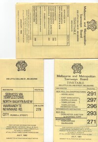
Ephemera - Timetable/s, Melbourne & Metropolitan Tramways Board (MMTB), "MMTB Bus Timetables", 1981 - 1984
Timetables for specific routes, day of week giving information on tram times at specific time points, route map, sections and fares and organisation address - 616 Little Collins St. Melbourne. All printed on yellow paper. .1 - Timetable for Box Hill via Shoppingtown and Templestowe, Doncaster bus services, dated July 1981 - routes 291, 297, 296, 293 and 271. .2 - Services via Templestowe, North Balwyn and Kew, Warrandyte and Newmans Rd - routes 276, 278 and 279 - July 1982 .3 - Services via East Doncaster, North Balwyn, Kew, Warrandyte, City, Shoppingtown - routes 277, 280, 281 and 268 - dated Jan. 1983 .4 - ditto as above, including Park Orchards and Donvale - routes 265, 262, 261, 260, 266 and 264 - dated Feb. 1983 .5 - North Altona - City Route 232 - April 1984 - issued by Metropolitan Transit with their logo. 6 - Garden City, Port Melbourne - City - Sept 1982 - routes 201, 202 7 - Sunshine - Footscray - City - Routes 230 and 231 - Jan. 1982 8 - North Altona - City - MMTB logo, route 232 - Nov. 1982 9 - East Kew, Box Hill, Doncaster - Express bus - Box Hill to City - routes 284, 270, 300 - April 1982 10 - Ringwood - Warrandyte, Park Orchards, Mitcham - routes 313, 31, 315 and 316 - Jan. 1983Yields information about MMTB Bus services early 1980s and 1 The Met badged item.Set of 9 MMTB and 1 MTA Bus timetables, folded sheets, 8 sections.trams, tramways, mmtb, timetables, melbourne, fares, east kew, box hill, doncaster, north altona, route 232, route 201, route 202, route 220, route 231, route 284, route 270, route 300, route 313, route 314, route 315, route 316 -
 Melbourne Tram Museum
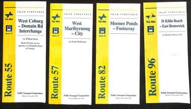
Ephemera - Timetables - set of four The Met, Public Transport Corporation (PTC), Nov. 1994
Yields information about The Met tram routes and their timetables..1 - Route 55 - West Coburg - Domain Interchange via William St - dated Nov. 1994 .2 - Printed 28-page book stapled timetable for "West Maribyrnong - City Route 57" tram service, dated Nov. 1994. The "The Met" logo, was published by the Public Transport Corporation. Document No. TT011 Provides a map, description of route, time points, timetable, ticketing information, some ticketing information, introduction by the Manager Essendon Depot, including a photo - Chris Hatzis and an image of a single truck (No. 8) tram available for hire as a party tram and a adverts for the City Circle Tram and Queen Victoria Market. .3 - Route 82 - Moonee Ponds - Footscray - dated Nov. 1994 .4 - Route 96 - St Kilda Beach - East Brunswick - dated March 1994trams, tramways, tickets, the met, tram services, timetables, route 57, city circle, route 55, route 82, route 96 -
 Melbourne Tram Museum
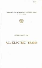
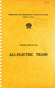
Document - Tender Document, Melbourne & Metropolitan Tramways Board (MMTB), "Tender Schedule for All-Electric Trams - Contract 2500", Jul. 1972
Comb bound (white plastic) specification or tender document, approx. 70 pages, with glossy card covers, titled "Tender Schedule for All-Electric Trams" and "Contract 2500", published by the Melbourne and Metropolitan Tramways Board, closing Monday 2 October 1972. Details the conditions of tender, conditions of contract, notes, specification, gives background information about Melbourne, dimensions, performance, drivers and conductors, trucks, wheels, brakes, electrical equipment, control panels and drawings. The drawings give a map of the system, typical city route, Glenferrie Road route (grade diagram), concrete track construction, min. radius curves, loading gauge, all-electric tram and mounting details for the trolley base, schedule of prices, tender form, form of contract, schedule of information to be provided by the tenderer. On the inside of the cover is a memo from D. Snell, Deputy Chairman to the Testing Engineer, dated 11/7/1972 about the tender being issued, but requesting least publicity and all enquiries to Mr. Snell. Part of the work to tender for the construction of Z class trams. Document scanned to pdf file word searchable. See Item 4388 for the Z3 document and 1583 for an August 1966 version and Reg item 4667 for a draft June 1965 version. 2nd copy added 7/8/2020 from Keith Kings papers.In in pencil in the top right hand corner of cover "1975" crossed out and "1972" written in. On first sheet in pencil, "Howard Smith" and "Laboratory 10 Feb 1975" stamped on.trams, tramways, specification, tenders, z class, mmtb, melbourne -
 Melbourne Tram Museum
Document - Tender Document, Melbourne & Metropolitan Tramways Board (MMTB), "Design, Manufacture and delivery of 100 only all-electric trams", Aug. 1966
Comb bound (white plastic) specification or tender document, approx. 70 pages, with glossy card covers, titled "Tender Schedule for All-Electric Trams", published by the Melbourne and Metropolitan Tramways Board, closing 12 September 1966. Details the conditions of tender, conditions of contract, notes, specification, gives background information about Melbourne, dimensions, performance, drivers and conductors, trucks, wheels, brakes, electrical equipment, control panels and drawings. The drawings give a map of the system, typical city route, Glenferrie Road route (grade diagram), concrete track construction, min. radius curves, loading gauge, all-electric tram and mounting details for the trolley base, schedule of prices, tender form, form of contract, schedule of information to be provided by the tenderer. Second copy from same donor added 9-3-2017 See Reg Item 2266 for the 1972 version and 4667 for a draft version - dated June 1965. See Item 4388 for the Z3 document. See Reg Item 4049 for associated newspaper cuttings.In red felt pen on top right hand corner "(1966)". Has stamp "Discarded from PTC Library 22 Oct. 1989" on front cover. 2nd copy has "1966" in ink in top right hand corner.trams, tramways, specification, tenders, z class, mmtb, melbourne -
 Melbourne Tram Museum
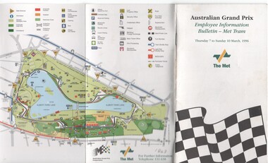
Pamphlet, The Met, "Australian Grand Prix - Employee Information Bulletin - Met Tram", Mar. 1996
Pamphlet or booklet - 20 pages, full colour printed on paper with a fold out map at the rear, centre stapled titled "Australian Grand Prix - Employee Information Bulletin - Met Tram". Published by The Met for the 1996 Grand Prix. Has details of the services, major loading points, rosters at the depot, traffic management, door procedures, crew arrangements and a calendar of events. Includes maps in the front of the Albert Park and the race course and loading points. Published for crew use. pdf copy added 28/9/17.trams, tramways, grand prix, albert park, events, the met -
 Melbourne Tram Museum
Document - Notice, Melbourne & Metropolitan Tramways Board (MMTB), "For Your Information", 9/1979 and 8/1980
Set of two foolscap notices regarding fares, travel cards, concession cards, day trippers, and general information. .1 - Blue foolscap sheet - titled "For your Information", for fares changes from 16/9/1979, gives details of fares and prepaid tickets in books of 20, also vintage tram trips, tram and bus charter rates, maps, timetables and contact details. .2 - pink foolscap sheet - titled "Information Guide for passengers:, as above, applicable from 3/8/1980, has details on section savers, day trippers, metro cards, etc.trams, tramways, notices and information, mmtb, fares, tickets, charters, information -
 Melbourne Tram Museum
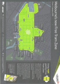
Map, Public Transport Victoria (PTV), "Melbourne's new Free Tram Zone", 2015
Printed A4 sheet - single sided off white sheet titled ""Melbourne's Free Tram Zone Map"., details the extent of the free tram zone or showing the tram lines that the free travel is allowed, locations, land marks, contact numbers and has the PTV logo in the top right hand corner and the Myki locos along with Yarra Trams and contact details for information. Dated 1/1/2015.trams, tramways, yarra trams, ptv, maps, free tram, melbourne -
 Melbourne Tram Museum
Pamphlet, Public Transport Victoria (PTV), "Buses replace trams", Feb. 2019
Pamphlet - six fold - A3 to DL side three colour printed on off-white paper, titled "Buses replace trams", advising intending passengers of the work between 23/2/2019 and 7/3/2019 due to track renewal on Holmes and Nicholson streets in Brunswick. Has a map, list of service changes, bus replacement guides and contact information. Has the logos of Transport for Victoria, Yarra Trams and PTV. Two copies held.trams, tramways, nicholson st, holmes st, tramway construction, route 1, route 6 -
 Melbourne Tram Museum
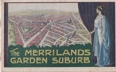
Book, T. M. Burke, "The Merrilands Garden Suburb", late 1919
Book - 12 pages with a fold out double page centre map, centre stapled, titled "The Merrilands Garden Suburb", a real estate marketing brochure for area to the west of the Reservoir rail line, known locally as Merrilands. Marketed on being a gardens suburb to the then Town Planning situation. Contains a suggested loop tram system. Has sales conditions, general information. Marketed by T. M. Burke of 340 Collin St Melbourne. Fold out surveyors map, by Saxil Tuxen, Licensed Surveyor date Oct. 1919. Shows suggested tram routes, reserves, and civic centre.trams, tramways, real estate, reservoir, proposals, new tramway, land -
 Melbourne Tram Museum
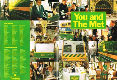
Pamphlet, Metropolitan Transit Authority (MTA), "You and the Met", 1983
Pamphlet - finished A4 full colour, 20 pages including 2 fold out sheets titled "You and the Met" issued July 1985 to introduce the Neighbourhood ticket system, new colour schemes and the "buzz" logo. Has a forward by Lynn Strouse, Chairman and Managing Director of the MTA. Explains the Met ticket system, types of tickets, map, Periodical tickets, concessions including the sixty save, and where to get information. Two copies held.trams, tramways, tickets, mta, the met, neighbourhood tickets, logos -
 Melbourne Tram Museum
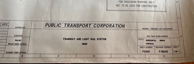
Drawing, Public Transport Corporation (PTC), Tramway and Light Rail System - P16245, 1990
Drawing shows the layout of the Melbourne tram system in 1990. Has a detail for the City area, prior to the expansion into Docklands and relocation of Batman Ave. Legend shows safety zones, loading zones, tram stops and substations, along with details of intersections, curves and crossovers.Yields detailed information about the Melbourne tram system layout in 1990.Dyeline print of drawing PTC drawing No. P16245tramways, tram stops, map, light rail, substations -
 Melbourne Tram Museum
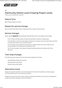
Document - Project Notice, Yarra Trams, "Glenhuntly Station Level Crossing Project works", May 2023
Project notice for - "Glenhuntly Station Level Crossing Project works" - tramway square. Gives details of alternative bus arrangements, maps and timing for the works. Work scheduled 5/5/2023 to mid July 2023.Yields information about the removal of the Glen Huntly station/road level crossing and the associated trackwork.Notice - 6 A4 page document - pdf version downloaded and printed version.tramways, public transport, level crossing, glen huntly road, glenhuntly, railway square, tramway square, trackworks -
 Melbourne Tram Museum
Document - Project Notice, Yarra Trams, "Collins St and Spencer St junction renewal works", June 2023
Project notice for - "Collins St and Spencer St junction renewal works" - Gives details of alternative arrangements, walking around the works, tram service changes, maps and timing for the works. Work scheduled 30/6/2023 to 9/7/2023. The last time that the junction was relaid was during 2011.Yields information about the renewal of the Collins St and Spencer St junction track work.Notice - 3 A4 page document - pdf version downloaded and printed version.tramways, public transport, collins st, spencer st, trackwork -
 Melbourne Tram Museum
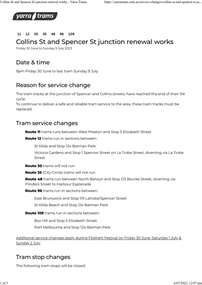
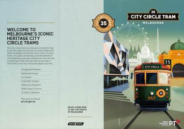
Pamphlet, Public Transport Victoria (PTV), "City Circle Tram", 2022
City Circle pamphlet - contains a map of the route and intersecting tram routes, with the route number "35" on both sides and major locations of interest. Has an image of W6 957 with a montage behind of inner Melbourne iconic buildings and the Docklands wheel. Gives times for the service with a QR code to check if the service is running that day Has Yarra Trams and PTV logos. In use during 2022/2023. On the day of cataloguing, Sunday, the service was shown as not running that day. Yields information about the City Circle tram service.Pamphlet - 3 fold DL - full colour. Two copies held.tramways, city circle, yarra trams, docklands, route 35, ptv -
 Melbourne Tram Museum
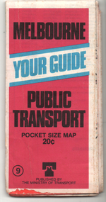
Ephemera - Map, Ministry of Transport, "Melbourne Your Guide PUblic Transport Pocket size map", 1979
... and transport information at the time. Melbourne map tram and bus ...Provided a detailed map of Melbourne's public transport, route number list and brief description. Has contact details for bookings and lost property etc. Priced 20c, published 1979 as map No. 9Demonstrates the methodology of providing map and transport information at the time.Fold out map (27 sections 9 across x 3 deep), coloured of Melbourne's Tram and Bus routes, route numbers, rail lines, detailed for the central part of Melbourne and insert section for Frankston. melbourne, map, tram and bus services, railways, mmtb, ministry of transport -
 Melbourne Tram Museum
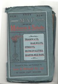
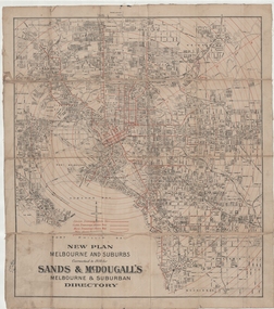
Map, Sands McDougall, Map of Melbourne and Suburbs showing Tramways, Railways, Streets, postal districts, Quarter-Mile Radii etc", c1922
Shows railways, cable and electric tram lines c1922. One of a number of maps produced by Sands McDougall of Collins St. Includes the Zoo horse tram lines. See acquisition and Research note by Duncan McAuslan. See items 2885, 6573, amd 6917 for other editions. On inside cover has current postal rates (including a war surcharge) and places worth visiting and on the rear cover, is an advertisement for Imperial ink.Yields information about Melbourne c1922 and its public transport lines. Produced by Sands and McDougall Pty Ltd of Collins St Melbourne. Folded sheet of paper 6 sections wide x 6 sections or folds deep contained within a green paper cover titled "Map of Melbourne and Suburbs showing Tramways, Railways, Streets, postal districts, Quarter-Mile Radii etc", showing both cable and electric tramways. maps, melbourne, cable trams, tramways, railways, horse trams, vr trams, sands mcdougall, zoo horse tramway, mmtb -
 Melbourne Tram Museum
Map, Sands McDougall, "New plan Melbourne and Suburbs Sands & McDougall's Melbourne and Suburban Directory", 1910
Shows railways, horse, cable and electric tram lines c1910. One of a number of maps produced by Sands McDougall of Collins St. Includes the MTOCo zoo horse tram lines, the NMETL and VR lines, but not the PMTT. Includes the Caulfield Elsternwick horse tram lines. Possibly included in Sands and McDougall directories based on the title. See items 2885, 6573 and 6916 for other editions. Yields information about Melbourne c1910 and its public transport lines. Cloth-backed and folded sheet of paper 5 sections wide x 4 sections or folds deep. Produced by Sands and McDougall Pty Ltd of Collins St Melbourne. maps, melbourne, cable trams, tramways, railways, horse trams, nmetl, vr trams, sands mcdougall, zoo horse tramway -
 Melbourne Tram Museum
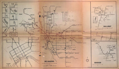
Map - Melbourne - Ballarat - Bendigo Tramways, 23-9-1969
Provides a detailed map of Melbourne, Ballarat and Bendigo tram lines - dated 23-9-1969. Shows street names, depot locations, depot layouts, track details including an insert for Sturt St Ballarat and destination locations. Provides a scale for each system. Not known who prepared the drawing.Yields information about the three operable Victorian systems at the date of preparation.Printed - dyeline? map on a folded sheet of papermap, melbourne, ballarat, bendigo, tramways, diagram -
 Melbourne Tram Museum
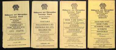
Ephemera - Timetables - MMTB Buses - set of 13, Melbourne & Metropolitan Tramways Board (MMTB), 1971 to 1973
Timetables - provide information on ticketing, fares, timing points, with a description of the route and a map. Not all services had been allocated a route number at the time. 1 - Garden City - Port Melbourne - City - routes 201, 202 - August 1972 2 - Williamstown Road - Footscray - Ballarat Rd - Route 223, Feb. 1972 3 - Deer Park, Sunshine Park, Sunshine, Footscray - City - routes 217, 219, 220, 229, 231 and 218 - Feb. 1972 4 - Deer Park West, Sunshine Park, Sunshine, Footscray - City - July 1973 5 - Fishermen's Bend - City - routes 233, 235 and 237 - March 1972 6 - Clifton Hill - Esternwick - Point Ormond - routes 246, 247 and 248 - August 1972 7 - Latrobe Uni - Northland - West Heidelberg - City - routes 256, 251, 253, 254, 252 and 255 August 1972 8 - East Kew, Box Hill, Doncaster, Shoppingtown - routes 284, 285 and 270 - July 1972 9 - Box Hill, Mitcham, East Doncaster, Ringwood - routes 287, 286, 288, 282, 283, and 272 - July 1972 10 - Box Hill - North Blackburn, route 290, printed on white paper - Sep. 1971 11 - Box Hill - Doncaster, Shoppingtown, Heidelberg, Templestowe, Serpells Rd and Lower Templestowe - routes 293, 296, 297, 271 - July 1972 12 Deer Park, Sunshine Park, Sunshine, Footscray - City - routes 217, 219, 220, 229, 231 and 218 - Saturdays and Sundays, printed on green paper - Feb. 1972 13 - Fishermans Bend - City - routes 233, 235 and 237 - June 1973 Yields information about MMTB Bus services during the 1970s. Set of twelve MMTB Bus timetables - multifolded printed on yellow paper, unless noted otherwise. timetable, mmtb, buses, port melbourne, garden city, williamstown rd, footscray, ballarat rd, sunshine, deer park, fisherman's bend, clifton hill, esternwick, point ormond, la trobe university, northland, west heidelberg, east kew, box hill, doncaster, shoppingtown, mitcham, ringwood, blackburn, templestowe, lower templestowe, fishermans bend -
 Melbourne Tram Museum
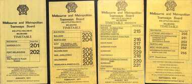
Ephemera - Timetables - MMTB Buses - set of 9, Melbourne & Metropolitan Tramways Board (MMTB), 1976 to 1978
Timetables - provide information on ticketing, fares, timing points, with a description of the route and a map. Not all services had been allocated a route number at the time. 1 - Garden City - Port Melbourne - City - routes 201 and 202 - Jan. 1977 2 - Bulleen - North Kew City - Routes 203, 204, 205, 206, 208 and 209 - Feb. 1977 3 - Deer Park West - Sunshine - Footscray - City - routes 215, 216, 217, 219. 218, 220, 231 with a Saturdays and Sundays timetable sheet printed on green paper - Aug. 1977 4 - La Trobe University - Northland - West Heidelberg - City - routes 256, 251, 253, 254, 252, 255 - Sept. 1978 5- Warrandyte - Park Orchards - Ringwood - routes 273, 274, 275 - June 1976 6 - Warrandyte - Donvale - Templestowe - Shoppingtown - City - routes 276, 277, 278, 294, 278, 280, 299, 268 - July 1976 7 - Box Hill - Mitcham, East Doncaster, Ringwood - routes 287, 286, 288, 282, 283, 272 - June 1976 8 - Box Hill - North Blackburn - route 290 - June 1976 9 - Box Hill - Heidelberg, East Doncaster, Shopping town - routes 291, 297, 296, 293, 271 and 269 - Sept. 1976Yields information about MMTB Bus services during the mid 1970s. Set of nine MMTB Bus timetables - multifolded printed on yellow paper, unless noted otherwise. timetable, mmtb, buses, port melbourne, garden city, deer park, fisherman's bend, west heidelberg, box hill, doncaster, shoppingtown, mitcham, ringwood, blackburn, templestowe, lower templestowe -
 Melbourne Tram Museum
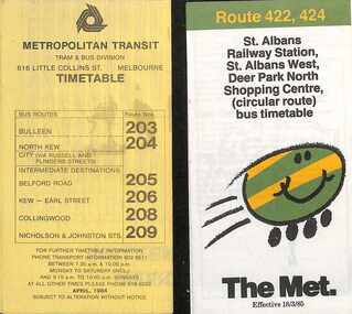
Ephemera - Timetables - The Met - buses - set of 2, The Met, 1984 and 1985
Timetables - provide information on ticketing, fares, timing points, with a description of the route and a map. 1 - Bulleen - North Kew - City, Belford Rd, Collingwood - routes 203, 204, 205, 206, 208, 209 - with the first "The Met" logo - April 1984 2 - St Albans - Deer Park North Shopping Centre - circular route - with the smiley face on wheels logo - dated 18/3/1985.Yields information about MMTB Bus services during the mid 1980s. Set of two The Met timetables, one printed on the folded sheet of yellow paper and the other on white paper.timetable, bulleen, north kew, collingwood, the met, deer park, st albans -
 Melbourne Tram Museum
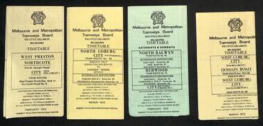
Ephemera - Timetables - MMTB trams - set of 7, Melbourne & Metropolitan Tramways Board (MMTB), 1972
Timetables - provide information on ticketing, fares, timing points, with a description of the route and a map. 1 - West Preston - Northcote - City - routes 9, 10, 11 - Feb. 1972 2 - North Coburg with connecting bus to Fawkner and Gowrie - Upfield on Sundays route 19, 20 and 18 - March 1972 3 - North Balwyn Burwood - City - routes 48, 40, 41, 37, 74, 75, 76, 28 - Feb. 1972 4 - West Coburg - Domain Road and West Coburg City on Sundays - routes 55, 56 and 68 - March 1972 5 - West Maribyrnong - City - (bus routes on Sunday only) - routes 57, 54, 60, 58 and 50 - Feb. 1972 6 - Essendon Aerodrome - City - route 49, 49, 52 and 51 - March 1972 7 - Footscray - Moonee Ponds - bus route on Saturday afternoons and Sundays - route 82 Feb. 1972Yields information about MMTB tram services during 1972Set of seven MMTB tram timetables - multifolded printed on yellow or green paper.timetable, mmtb, route 10, route 9, route 11, route 19, route 18, route 20, route 48, route 40, route 41, route 37, route 74, route 75, route 76, route 28, route 55, route 56, route 68, route 57, route 54, route 60, route 58, route 50, route 59, route 49, route 52, route 51, route 82 -
 Melbourne Tram Museum
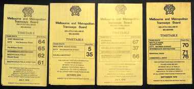
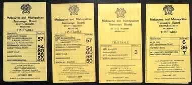
Ephemera - Timetables - MMTB trams - set of 8, Melbourne & Metropolitan Tramways Board (MMTB), 1976
Timetables - provide information on ticketing, fares, and timing points, with a description of the route and a map. Not all services had been allocated a route number at the time. 1 - East Brighton - City and via William St - routes 64, 65, 62 and 61 - July 1976 2 - Malvern (Burke Rd) to City and via Wiliam St - routes 5 and 35 - Oct. 1976 3 - Carnegie - City and via William St - routes 67, 37, and 66 - July 1976 4 - Wattle Parke - City and Camberwell depot - routes 70, 71 and 76 - Sept. 1976 5 - Kew - Cotham Road to St Kilda Beach - route 69 - August 1976 6 - East Preston - via Bourke or La Trobe, and East Brunswick - routes 88, 14, 89. 90, 96, 95, and 97 - Feb. 1976 7 - Toorak - City and via William St - routes 8 and 38 - August 1976 8 - St Kilda Beach and South Melbourne Beach and via William St - routes 15, 16, 53, 55, 1, 2 and 4 - Sept. 1976 Yields information about MMTB tram services during the 1970s. Set of 8 MMTB tram timetables - multifolded printed on yellow paper.timetable, mmtb, wattle park, east brighton, malvern, carnegie, kew, east brunswick, toorak, st kilda beach, south melbourne beach, route 64, route 65, route 62, route 61, roure 5, route 35, route 67, route 37, route 66, route 70, route 71, route 76, route 69, route 88, route 96, route 8, route 38, route 15, route 1, route 2, route 55, route 53 -
 Melbourne Tram Museum
Ephemera - Timetables - MMTB trams - set of 5, Melbourne & Metropolitan Tramways Board (MMTB), 1977 and 1979
Timetables - provide information on ticketing, fares, and timing points, with a description of the route and a map. Not all services had been allocated a route number at the time. 1 - West Maribyrnong - City - routes 57, 54, 60, 58 and 50 - Oct. 1979 2 - West Maribyrnong - City - routes 57, 54, 60, 58 and 50 - Feb. 1977 3 - East Malvern (Darling Rd) City - route 3 - Feb. 1977 4 - Glen Iris - City and via William St - routes 6, 36 and 7 - Jan. 1977 5 - Wattle Park - City - routes 70, 71 and 76 - Nov. 1979Yields information about MMTB tram services during the 1970s. Set of 5 MMTB tram timetables - multifolded printed on yellow paper.timetable, mmtb, west maribyrnong, east malvern, glen iris, route 57, route 54, route 60, route 58, route 50, route 3, route 6, route 36, route 7, wattle park, route 70, route 71, route 76 -
 Melbourne Tram Museum
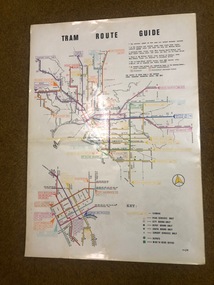
Map, Melbourne & Metropolitan Tramways Board (MMTB), "Tram Route Guide", Jun. 1982
Full colour map or poster printed on clear plastic with an adhesive peel off backing sheets, titled "Tram Route Guide". Map dated 6/82, showing routes with route numbers and names of main destinations. Has notes about the services, weekend bus replacements and telephone numbers for information. 1982 Note this version does not show the route 88 extension as similar map 1098 or 3765 does, but is a later version.trams, tramways, mmtb, map, routes, posters -
 Melbourne Tram Museum
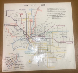
Map, Melbourne & Metropolitan Tramways Board (MMTB), "Tram Route Guide", Aug. 1979
Full colour map or poster printed on clear plastic with an adhesive peel off backing sheets, titled "Tram Route Guide". Map dated 8/79, showing proposed extension to Bundoora, routes with route numbers and names of main destinations. Has notes about the services, weekend and telephone numbers for information. 1979 2 copies held. See Reg Item 1098 for a smaller version of this map.trams, tramways, mmtb, map, routes, posters -
 Melbourne Tram Museum
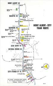
Map, Melbourne & Metropolitan Tramways Board (MMTB), Set of 15 tram route maps, 1977 to 1979
Series of 15 colour route maps for various tram lines or groups of tram lines for the MMTB. Some have the Transport Information Centre telephone printed on them, others have a label stuck on. Some are finished with a plastic laminate finish on either one or both sides. Show the major cross streets, parks, schools, other tram routes, major stop numbers and railway lines. Two copies of each held unless noted otherwise. .1 - Mont - Albert City - R11/77, shows routes 43. 47. 45. 44 .2 - Malvern, East Malvern, Carnegie and East Brighton Tram Routes (from St Kilda Junction) - R1/79 - shows routes 5, 3, 67, 66, 61, 62 and 64. .3 - Swanston St tram guide - R1/79 - lists all routes and route numbers that branch or cross Swanston St between Grattan St and St Kilda Junction. .4 - St Kilda Rd Tram Routes R12/77 - details South Melbourne Beach, route 1 and route 2 and St Kilda Beach routes 15, 16 and 55 otherwise shows were the various routes branch off St Kilda Road. Copy 1 has "P14909" in pencil in the bottom right hand corner. .5 - Kew - St Kilda Beach - R1/79 - Route 69. .6 - Footscray - Moonee Ponds - R3/81 - Route 82 .7 - Flinders St tram routes - R5/78 - North Balwyn, East Burwood, routes 48, 40, 41, Hartwell, 28, 74 and 75 .8 - William St tram routes - Route 55, 56 and 63 - South Melbourne Depot and Domain. copy 2 has "P14913" in bottom right hand corner. .9 - Toorak Camberwell and Glen Iris tram routes with Camberwell Junction and Malvern Town Hall, R1/79, routes 8, 7, 6, 72 and 73 shown. .10 - Swanston St tram routes - R12/77 - shows all the Swanston St routes, including East Coburg and Moreland. .11 - Bourke St tram routes - R4/77 - East Brunswick Blyth St and East Preston Tyler St and intermediate routes, routes 95, 96, 97, 90, 89 and 88. .12 - as for .11, dated 1/85, showing extension to La Trobe University - has Metropolitan Transit logo. Only 1 copy held. Also shows route 92 and 87. .13 - Batman Ave tram routes - R9/77 - Wattle Park, North Richmond and Prahran - routes 70, 71, 78 and 79. .14 - City route guide - R9/77 - showing all route numbers and destinations that passed through the CBD. .15 - Elizabeth St tram routes - R12/77 - Essendon Airport, West Maribyrnong, North Coburg lines, routes 50, 58, 60, 54, 57, 52. 49, 59, 18, 20 and 19. Copy 1 has "P14905" in pencil in bottom left hand corner.trams, tramways, maps, route guide, route numbers, routes, mont albert, route 43, route 47, route 45, route 44, route 42, malvern burke rd, east preston, carnegie, east brighton, south caulfield, route 5, route 3, route 67, route 62, route 64, route 66, glenhuntly tram depot, swanston st, st kilda rd, south melbourne beach, st kilda beach, route 1, route 2, route 15, route 16, route 55, kew- cotham road, route 69, route 79, route 82, footscray, moonee ponds, flinders st, north balwyn, kew, east burwood, burwood, hartwell, richmond, route 48, route 40, route 41, route 28, route 74, route 75, route 56, route 63, william st, west coburg, toorak, camberwell, glen iris, malvern town hall, route 72, route 73, route 7, route 8, bourke st, route 6, route 95, route 96, route 97, route 90, route 89, route 89, east preston, east brunswick, la trobe university, clifton hill, route 92, route 87, route 70, route 71, route 78, route 79, north richmond, prahran, wattle park, essendon airport, west maribyrnong, north coburg, route 50, route 58, route 60, route 54, route 57, route 52, route 49, route 59, route 18, route 20, route 19, batman ave -
 Melbourne Tram Museum
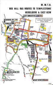
Map, Melbourne & Metropolitan Tramways Board (MMTB), Set of 8 bus route maps, 1977 to 1979
Series of colour route maps for various bus or groups of tram lines for the MMTB. Some have the Transport Information Centre telephone printed on them, others have a label stuck on. Some are finished with a plastic laminate finish on either one or both sides. Show the major cross streets, parks, schools, other tram routes, major stop numbers and railway lines. .1 - Box Hill bus routes to Templestowe - R38/82, Heidelberg and East Kew, includes Doncaster, Shoppingtown and Newmans Road. .2 - Clifton Hill - R2/79 - Elsternwick, Point Ormond and St Kilda Junction .3 - Footscray, Sunshine, Deer Park, Nth Altona, Fishermen's Bend, Highpoint and Williamstown Road - R2/79. .4 - Bulleen - City - Port Melbourne - Garden City Bus Route, including Kew, Collingwood - R6/78 .5 - City - Warrandyte and East Doncaster including Newmans Road, Templestowe, East Doncaster, Donvale, Shopping town, and Kew. R3/82. .6 - West Heidelberg, La Trobe University, Northland - R3/81 .7 - Box Hill, Ringwood to East Doncaster and Warrandyte, Park Orchards, North Blackburn R3/82. .8 - Geelong - Herne Hill, Rollins Road, Donnybrook Rd, North Shore and Corio Villagetrams, tramways, maps, route guide, route numbers, routes, buses, box hill, templestowe, doncaster, east kew, heidelberg, clifton hill, point ormond, elsternwick, footscray, sunshine, deer park, north altona, fishermen's bend, highpoint, williamstown rd, bulleen, kew, collingwood, port melbourne, garden city, warrandyte, donvale, la trobe university, northland, ringwood, park orchards, mitcham, blackburn, geelong -
 Melbourne Tram Museum
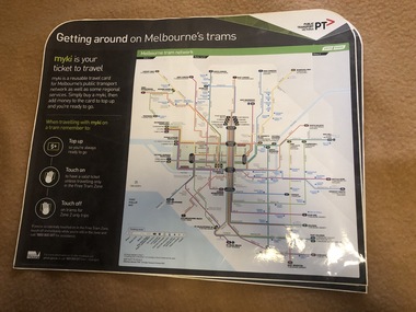
Map, Orajet, "Melbourne tram network", "Getting around on Melbourne's trams", Jan. 2015
Large plastic sheet, with an adhesive back and cover protective sheet - titled "Melbourne tram network" and "Getting around on Melbourne's trams" with PTV, Metro, Yarra Trams logos, shows fare zones, ticketing, free tram zone and information about Myki and how to use it.. Published 2015. Printed by Orajet, digital printing media. Has rounded corners along the top edge and square corners in both bottom corners. Two copies held.On rear in felt pen "Camira Orange Fine"trams, tramways, yarra trams, ptv, maps, free tram, melbourne, myki