Showing 14493 items matching "property"
-
 Whitehorse Historical Society Inc.
Article, Plaques unveiled, 1970
Commemorative plaques were unveiled at Antonio Park.Commemorative plaques were unveiled at Antonio Park, dedicated to the Antonio Family who settled on the site and later bequeathed the property to the Nunawading City Council (Photo of niece of the Antonio brothers)Commemorative plaques were unveiled at Antonio Park.antonio park mitcham, dobie, dorothy, rotary club of nunawading, sheppard, harry, antonio family, city of nunawading -
 Eltham District Historical Society Inc
Document - Property Binder, 1045 Main Road, Eltham
Businesses, Eltham, Eltham Physiotherapy & Sports Injuries, Main Roadmain road, eltham, property, shops, businesses, russell yeoman, jim connor, eltham district historical society, plenty river, old eltham road, kangaroo ground, nillumbik council, barry rochford, main road eltham, luck street eltham, aladdin antiques montmorency, main road eltham roundabout, steven white, geoff glynn, michael murray, harold herd, enver camdal, helen bodycomb, rhonda noble, jeph neale, chris marks, john brumby, andrew haermeyer, sherryl garbutt, eltham shopping centre, eltham chamber of commerce and industry, norman williams, pat power, john graves, wattletree road eltham, bolton street eltham -
 Whitehorse Historical Society Inc.
Article - Manningham Matters, Dr Richard Lay, Highways and Byways of Manningham, June 2021
August Schwerkolt walked between his properties at Northcote and Mitcham and probably crossed the Yarra River at the Banksia St bridge and took the ridge route which is now the Manningham, Doncaster and Mitcham Roads.August Schwerkolt walked between his properties at Northcote and Mitcham and probably crossed the Yarra River at the Banksia St bridge and took the ridge route which is now the Manningham, Doncaster and Mitcham Roads.non-fictionAugust Schwerkolt walked between his properties at Northcote and Mitcham and probably crossed the Yarra River at the Banksia St bridge and took the ridge route which is now the Manningham, Doncaster and Mitcham Roads.schwerkolt august, mitcham, doncaster road, mitcham road -
 Eltham District Historical Society Inc
Document - Property Binder, 66 Susan Street, Eltham
Newspaper clipping (photocopy/digital only): End for a historic house, Lyndal Reading, Diamond Valley Leader, February 1, 2006, p9Alistair Knox Park, Eltham, Eltham Skate Park A small cream cottage with green roof. The farmhouse built in the late 1800s by the Crozier Family. Subsequently owned by the Hill Family. Purchased in the early 1960s and by 1965 the property was owned by the Shire of Eltham. Employees of the Shire lived in the house. Susan Street originally ran all the way north of Bridge Street to the bend where it turned to the left into Brisbane Street. Today that section of Susan Street has been renamed as an extension of Brisbane Street. In 2006 the Shire of Nillumbik demolished the house which had been subject to extensive vandalism. In accordance with heritage advice and a permit condition a sign was placed on the site outlining the history of the building. This was installed and remained in place till about 2016 when it was removed. The land adjoins Alistair Knox Park. By 2010 the Eltham Skate Park was developed. In 2022 a major renovation and extension took place. Sources: EDHS Newsletter No 171 November 2006alistair knox park, eltham, eltham skate park, house, susan street -
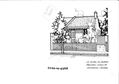
 Kew Historical Society Inc
Drawing - Property Illustration, Margaret Picken, 7 Hume Street, Kew, 1998
After training as a Cartographic Draftsman within the mining industry, I worked as a property illustrator for real estate firms in the eastern suburbs of Melbourne for 23 years from 1983. I initially photographed houses with a Polaroid camera and made a 'thumbnail' sketch while there. The photos were used to scale off a sketch in pencil and then that sketch was overlaid with drafting film and the 'pen and ink' completed. The pens I used were the Rotring ‘Rapidigraph’ drafting pens. The ink was also made by Rotring (German).The film was ‘Rapidraw’, polyester drafting film, double matte. It takes a very fine line and doesn’t bleed. As well as house sketches, there were often floor plans and site plans ordered. Aerial sketches were ordered when the property needed an overall view. (Margaret Picken, 2020)The house at 7 Hume Street was designed in 1955 by the modernist architect Douglas Alexandra (1922-2000). Between 1951 and 1996, Alexandra completed a number of significant projects including a regional art gallery and library complex at Hamilton, Victoria (1958-59). The residence in Hume Street is included in the RAIA Victorian Chapter's 20th Century Buildings Register. The house, and another residence in Molesworth Street (1961), is one of his notable residential projects. The aerial property illustration of the house by Margaret Picken was commissioned by the real estate agent Woodards in 1998. Gift of Margaret Picken, 2020Pen and ink property illustration on drafting film of 7 Hume Street, Kew by Margaret Picken.7 HUME ST., KEW / MARGARET PICKEN ~98 / WOODARDS ~ HAWTHORN artist -- margaret picken 1950-, 7 hume street - kew (vic)., d.d. alexandra - architect, property illustrations -- buildings -- kew (vic.) -
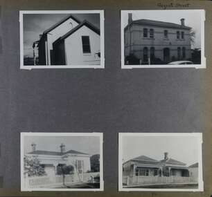 Glen Eira Historical Society
Album - Album page, Regent Street, Circa 1972
This photograph is part of the Caulfield Historical Album 1972. This album was created in approximately 1972 as part of a project by the Caulfield Historical Society to assist in identifying buildings worthy of preservation. The album is related to a Survey the Caulfield Historical Society developed in collaboration with the National Trust of Australia (Victoria) and Caulfield City Council to identify historic buildings within the City of Caulfield that warranted the protection of a National Trust Classification. Principal photographer thought to be Trevor Hart, member of Caulfield Historical Society. Most photographs were taken between 1966-1972 with a small number of photographs being older and from unknown sources. All photographs are black and white except where stated, with 386 photographs over 198 pages. At least 2 of these houses (17 and 84) are contributory properties to HO72 Elsternwick Estate and environs.Page 172 of Photograph Album with four photographs of differerent properties on Regent Street.Handwritten: Regent Street [top right] / 17 [under bottom left photo] / 84 [under bottom right photo] / 172 [bottom right]trevor hart, regent street, elsternwick, houses, mansions, cast iron work, verandahs -
 Lakes Entrance Historical Society
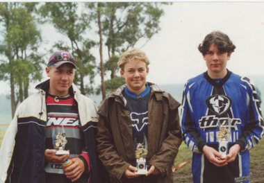
Photograph - Ben Dyllan Damien Alcodk and Jason Basaler, Lakes Post Newspaper, 1/11/2001 12:00:00 AM
Ben Dyllan Damien Alcodk and Jason Basaler placegetter in 125 cc Junior Motor Cross event held at Klienite property Bete Bolong VictoriaColour photograph showing Ben Dyllan Damien Alcodk and Jason Basaler placegetter in 125 cc Junior Motor Cross event held at Klienite property Bete Bolong Victoriaclubs, sports, events -
 Lakes Entrance Historical Society
Photograph - Daniel Joiner, Kyle DeCecco and Sam Whelan, Lakes Post Newspaper, 1/11/2001 12:00:00 AM
Daniel Joiner, Kyle DeCecco and Sam Whelan place getters of 80cc B grade Motor Cross meet at Kleinitz property Bete Bolong VictoriaColour photograph showing Daniel Joiner Kyle DeCecco and Sam Whelan place getters of 80cc B grade Motor Cross meet at Kleinitz property Bete Bolong Victoriaclubs, sports, events -
University of Melbourne, School of Chemistry
File
Properties of Solids -
University of Melbourne, School of Chemistry
File
Properties of gases -
University of Melbourne, School of Chemistry
File
Properties of liquids -
 Melton City Libraries
Photograph, Darlingsford, Unknown
Darlingsford propertylocal identities, local architecture, council -
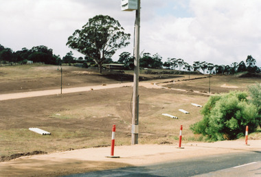 Lakes Entrance Historical Society
Photograph, Holding M, 2006
Property and subdivision believed to have been done by Bill and Kaye Reddenbach.Colour photograph of early stage of residential development showing roadways formed through property, drainage pipes placed ready for installation, street lighting in place. Photograph taken from school, looking east. Swan Reach Victorialand development, housing -
 Eltham District Historical Society Inc
Document - Property Binder, Eltham Town Square, Commercial Place, Eltham
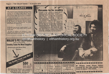
1. Dreams to be reality, The Valley Voice, 15 August 1979, p2 - announcement of proposed town square of 1800 square metres of shop area and open courtyard to be sited in the carpark between Arthur Street and Pryor street. The plans also included tree-lined walkways from both Arthur Street and a pededstrian footbridge across Main Road leading to aregular open-air market and tavern. Shop owners facing Main Road were to be encouraged to turn their businesses towards the square. On reverse side - 'General' Marshall and his troops; Valley votes in five new faces, The Valley Voice, 15 August 1979, p1 - picture showing newly elected Cr Robert Marshall 2. Square plan on display, Diamond Valley News, Tuesday, June 23, 1981, p1 - Council's prefered proposal on display to the public. On same page a story about the son of Cr Bob Manuell being attacked on the train from the city. On reverse side - Helping people - here and abroad by Marguerite Marshall, Diamond Valley News, Tuesday, June 23, 1981, p2 - about Keith Ryall of Zig Zag Road, the Apex international councillor for Australia 3. Plan: Eltham Town Centre property Acquisition, Shire of Eltham March 1994businesses, arthur street, bible street, commercial place, dudley street, eltham, franklins supermarket, luck street, main road, map, mcewans, pryor street, safeway supermarket, apex club, bronwyn ryall, keith ryall, zig zag road, cr bob manuell, cr robert allen, det sgt noel murphy, eltham chamber of commerce, eltham police, eltham shire council, eltham town square, lorraine manuell, pauline toner mp, robert manuell, rodney roscholler, shire planner, vicrail, elections, h&j white general store, hurstbridge, leslie bowker, main street, mrs marshall, pam lawson, robert marshall, rosemary tovey, central park, comfort station, eltham little theatre, montmorency, public toilets, rotex cinema, were street -
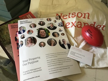 Greensborough Historical Society
Advertising package, Nelson Alexander, 25/05/2019
Promotional material issued on Nelson Alexander's "Foundation Day", 25 May 2019. Foundation Day is an initiative of the Nelson Alexander Charitable Foundation, supporting local charities. Includes five property description leaflets, business card, cloth shopping bag and miniature plastic AFL football.Advertising promotional package containing five property description documents and leaflets, business card, cloth shopping bag and miniature plastic AFL footballreal estate agents, nelson alexander -
 Hawthorn Historical Society
Drawing - Property Illustration, 16A Haines Street, Hawthorn
'After training as a Cartographic Draftsman within the mining industry, I worked as a property illustrator for real estate firms in the eastern suburbs of Melbourne for 23 years from 1983. I initially photographed houses with a Polaroid camera and made a 'thumbnail' sketch while there. The photos were used to scale off a sketch in pencil and then that sketch was overlaid with drafting film and the 'pen and ink' completed. The pens I used were the Rotring ‘Rapidigraph’ drafting pens. The ink was also made by Rotring (German).The film was ‘Rapidraw’, polyester drafting film, double matte. It takes a very fine line and doesn’t bleed. As well as house sketches, there were often floor plans and site plans ordered. Aerial sketches were ordered when the property needed an overall view.' (Margaret Picken, 2020)This property illustration is one of a series created by Margaret Picken for a range of real estate agents in Melbourne between c. 1983 and c. 2006. Each work is signed and dated by the artist.Gift of Margaret Picken, 2020Pen and ink property illustration on drafting film of 16A Haines Street, Hawthorn by Margaret Picken. Incorrectly labelled as 18 Haines Street, as signified by the 'wrong sketch' marking at the top.18 Haines Street, Hawthorn, Margaret Picken, 99, Woodards - Hawthorn. Wrong Sketch.artist - margaret picken 1950- -
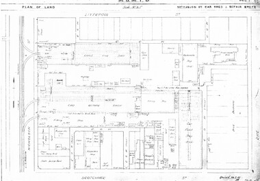 Melbourne Tram Museum
Drawing, Melbourne & Metropolitan Tramways Board (MMTB), "Central Bus Garage", "Nicholson St car shed and repair shops", c1938
Set of four photocopied plans or drawings on A3 sheets of the "Central Bus Garage" and the "Nicholson St car shed and repair shops" .1 - Plan showing block and details of the cable car facilities, repair shops and car paint shop - drawing dated 28-7-1933. .2 - Plan of the block showing the various properties and buildings - shows bus garage location. .3 - South part of drawing No. 1019 - showing the various properties, title details, purchased costs and dates - includes the hospital at Rae St - see Reg Item 1738.2 for details. Dated 8/1940. .4 - North part of the above drawing.trams, tramways, drawings, depots, property, cable trams, nicholson st, central bus garage, buses -
 Coal Creek Community Park & Museum
Glass Bottle
Tall bottle with leaves inscribed on itThis Bottle is the property of O.T.LTD -
 National Vietnam Veterans Museum (NVVM)
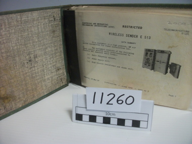
Manual, Wireless Sender E513
Green linen covered metal binder. Training manual for Wireless Sender E513. Plastic sleeve for each page of (Aust) Telecommunication sheetsProperty of US Governmentmanual, wireless communications -
 National Vietnam Veterans Museum (NVVM)
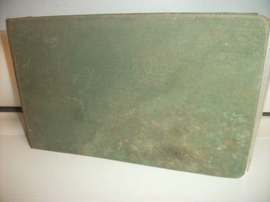
Manual, Wireless Sender C11, 1959 Approx
Green linen covered metal binder. Training manual for Wireless Sender C11. Plastic sleeve for each page of (Aust) telecommunication sheetsProperty of US Governmentmanual, wireless communications -
 Ringwood RSL Sub-Branch
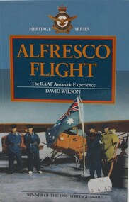
Book - RAAF, Royal Australian Air Force Museum, Alfresco Flight, Published 1991
The RAAF Antarctic Experience by David Wilson Soft Cover 135 printed pages, text and black and white photos. Property of the Ringwood RSL -
Whitehorse Historical Society Inc.
Document, Sylvia's memory gem
Sylvia Pilven, who is a local resident, relates stories of her life to Dorothy Williams.Sylvia Pilven, who is a local resident, relates stories of her life to Dorothy Williams. She was the last of the Williamson Family and lived to 98, dying in 1907. The Williamson family property was in Mt Pleasant Road TunstallSylvia Pilven, who is a local resident, relates stories of her life to Dorothy Williams. williamson, alfred, williamson, isabella, mount pleasant road tunstall -
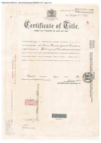 Ringwood and District Historical Society
Document, Certificate of Title - W.G. Carter, Grandview Grove, Warranwood, Victoria, (later Bemboka Road) - part of Crown Section Twenty, Parish of Warrandyte, County of Evelyn - 1947
A4 copies of Landata Victoria Historical Search documents - Vol 7052 Fol 1410222. Includes Carter Family Tree property notes. William George Carter of Grandview Grove Ringwood, Nurseryman, is now the proprietor - three acres or thereabouts shown on map (12202a) - 14th March, 1947. Transfer B284834 Registered 21 September, 1961 - 1 acre shown on map (12202c) north of Plymouth Road. NOTES ON GRANDVIEW GROVE PROPERTY (Carter Family Tree extract) The Grandview Grove property was purchased by William (Bill) and Doreen Carter in 1947 as three acres of uncleared bushland. They had a 2 bedroom fibro-cement house built on the land which they informally called "Willoreen". With Doreen looking after sons Peter (born in 1940) and Robin (born in 1950), Bill worked locally at Croydon Dairy. The family spent much of their spare time clearing the land, where Bill then grew and sold fruit, flowers and berries, particularly strawberries, as a hobby and to supplement their income. Bill continued to do so while Peter and Robin were growing up, and after Doreen died in 1958. In 1961 Bill sold one of the three acres to one of his seven sisters, Grace, who lived in Kew but later moved to Rosebud and sold the land without ever building on it. During the 1960s, Grandview Grove was renamed Bemboka Road. After retiring as a milkman, Bill moved to Rosebud, Vic, and in 1977, sold the property to the Anglican Church, who were looking to invest in the site in anticipation of proposed future residential development in the area. As nearby properties were subdivided during the 1980s, the house, which the Church had initially utilised as low-cost family accommodation, was modified internaly to become a church/Sunday school. By the early 2000s, construction of a contemporary-design church and carparking area between the house and street alignment had been completed but the house remained as a detatched meeting room until falling into disrepair and was eventually demolished around 2010. -
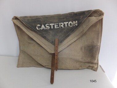 Flagstaff Hill Maritime Museum and Village
Functional object - Courier Bag, Government of Victoria, Late 19th to mid-20th centuries
The courier bag was once government property, as indicated by the broad arrow symbol. The flap has the name 'Boronia' - an area near Melbourne - overstamped with the town name 'Merino', and on the other side of the flap is the town 'Casterton'. Merino and Casterton are renowned for large sheep farming properties in Victoria's western district. Perhaps the courier bag was originally used between Melbourne and Boronia. During the late 19th and early-to-mid 20th centuries, a government-operated railway service was active in in the western district of Victoria. It served remote properties, including a line between Merino and Casterton. The train delivered mail, cash, supplies documents, business records and people between the sheep farm properties and the township of Casterton.This courier bag is an example of the connections and business between people in the remote areas of western Victoria. It was likely used by Victoria's railway system that transported people, goods, documents and cash between the districts of western Victoria.Courier bag; beige canvas rectangular bag with triangular black canvas flaps and a leather strap and buckle closure. The bag has stencilled stamps of three towns - Casterton, Merino and Boronia. It also has the government property symbol of a broad arrow.White stencilled paint "CASTERTON" Black stencilled paint "BORONIA" [barely visible] White over-stamped stencilled paint "MERINO"warrnambool, shipwreck coast, flagstaff hill, flagstaff hill maritime museum, flagstaff hill maritime village, bag, pouch, document pouch, courier bag, western district, western victoria, 19th century, 20th century, railway, rural business, rural trade, boronia, casterton, merino, sheep farm, sheep property, canvas bag, canvas courier bag, government courier bag, broad arrow -
 Surrey Hills Historical Society Collection
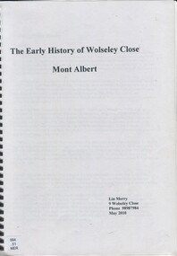
Book, The early history of Wolseley Close, Mont Albert, 2010
Includes copy of will of William Clark. Resident of the property at 9 Wolseley Close in 1910. Includes copy of the Alan Holts home occupier / tenant records - names from 1920 - 1980. Includes photo of Wolseley Close house, taken 1888/1889 plus colour photo of Wolseley Close house taken by Lin Merry, 2010. Land Title information, surveys, subdivision Includes list of occupants of the house, p.17Includes some plans of houses built in Wolseley Close, Mont Albert, Victoria. Outlines details of property at 9 Wolseley Close19p : col illcragg family, windsor crescent, surrey hills, (mr) william ainger, (mr) isaiah ainger, whitehorse road, noorn hill, house names, koonda, d j maloney, (mrs) louisa clara maggs, taramera, union road, st.abbs, york street, (mr) william henry cleverdon, wolseley street, windsor park estate, tarawera, merry family, clinton family, adams family, tel-el-kebir, farrell family, (mr) william clark, trafalgar street, (mr) (sir) matthew davies, (mr) c h james, (mr) james munro, (mrs) elizabeth clark, langdale, (mr) stanley dewar, (mr) john jose, (mrs) emily hampton, potton, (mr) alexander potton, (mr) john atkinson morris, freehold investment & banking co., mont albert, windsor park surrey hills, dalton family, (mr) henry wood, wolseley close -
Whitehorse Historical Society Inc.
Document, Winlaton, 1/11/2008 12:00:00 AM
Short history of 'Winlaton', a grand home built by J. T. Tweddle in 1909.Short history of 'Winlaton', a grand home built by J. T. Tweddle in 1909. The property was later converted to an institution for girls named 'Winlation Youth Training Centre'. The Building was demolished in the early 1990s for residential development.Short history of 'Winlaton', a grand home built by J. T. Tweddle in 1909. winlaton youth training centre, residential development -
 Sunbury Family History and Heritage Society Inc.
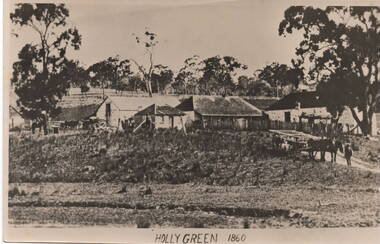
Photograph, 'Holly Green' 1860
The property in the photograph is 'Emu Bottom' possibly after George Evans leased it, as the caption across the image reads 'Holly Green' 1860.An old non-digital black and white photograph with a cream border of a rural property showing the homestead on the RHS and three out buildings and trees in the background. A man is standing with a horse and open dray on the lower RHS of the image.'emu bottom', holly green, george evans, sunbury, homesteads -
 Warrnambool and District Historical Society Inc.
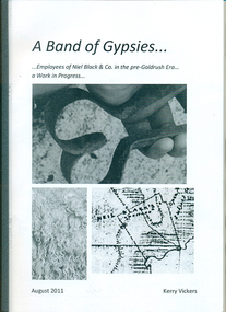
Booklet, A band of gypsies: employees of Niel Black & Co in the pre-goldrush era: a work in progress
Niel Black was an early settler in the Western District of Victoria who held large tracts of land including Glenormiston and The Sisters estates. Black was responsible for bringing many employees to the area. The employees' names, birthplace, arrival date, marriage partner/s, other employers are tabulated. An overview of Black's properties and conditions of the time is also included.This booklet documents those who came to the Western District to work for Niel Black prior to the goldfishes of the 1850s.In-house booklet with plastic sleeve outer cover, with black & white images of sheep shears, wool and a map of the Black property. All text is in black.emigration, employment, family history, early victorian squatters -
 Bendigo Historical Society Inc.
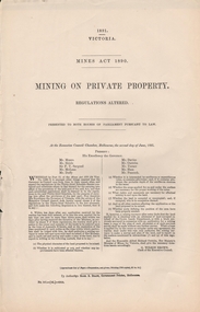
Document - MINING ON PRIVATE PROPERTY, 1891
MINING ON PRIVATE PROPERTYgovernment, state, mines act -
 City of Kingston
Pamphlet - Colour, Duffus Bros, Railway Reserve Highett, c. 1923
Sales plan for land in the suburb of Highett, titled Railway Reserve, incorporating properties along Wolseley Street, Livingston Street, Highett Road and Worthing Road. The developing urban area of Highett within the City of Kingston. This land sale pamphlet illustrates the subdivision of land within the municipality and the changing demographic of the district as new houses and shops are constructed close to infrastructure.Colour pamphlet advertising thirty eight shop and villa sites for sale at the Railway Reserve, Highett. Incorporates a map of the reserve with properties available on Wolseley Street, Livingston Street, Highett Road and Worthing Road. Handwritten in grey pencil: assumed sale price recorded on subdivisions 1-7, 10, 22, 23 and 34 Handwritten in grey pencil on subdivision 4: C. Nevill / City of Melbourne bank Handwritten in grey pencil across subdivision 7: 49' Handwritten in grey pencil across subdivision 21 and 22: 134' Handwritten in grey pencil across subdivision 25 and 26: 200' Handwritten in grey pencil across subdivision 36 and 37 and both top and bottom: 120' Hand drawn in blue pencil: outline of subdivision 4 Hand drawn in blue pencil: outline of subdivisions 7, 23, 28, 37, 38 along left hand side, subdivisions 38, 37 and 36 on Wolseley Street, subdivisions 30 and 29 along Wolseley Street, subdivisions 29 and 24 along the middle of the plan, subdivisions 24 and half of 25 along Livingston Street, half of subdivision 20 along the middle of the plan, subdivisions 21 and 22 along the Right of Way between Livingston Street and Highett Road, and along the right hand border of subdivision 7. Handwritten in ink adjacent to the subdivision plan, updside down, in the bottom right hand corner: 276 / 54 / 280 / 45 / 320 / 202 / 200 / 134 / horizontal line / 11/14 Handwritten in ink adjacent to the subdivision plan, updside down, in the bottom right hand corner: 1714)2200(15 / 1714 / horizontal line / 486land sales, highett