Showing 938 items matching "reservoirs"
-
 Wodonga & District Historical Society Inc
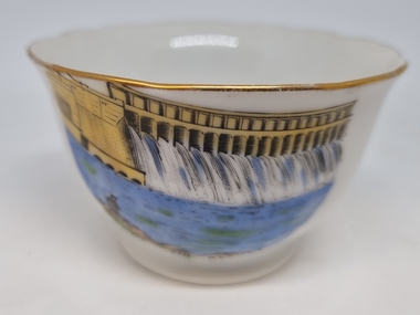
Souvenir - China Bowl - Hume Weir, Albury, Westminster Fine China Australia, c1957
This item is from a collection donated by descendants of John Francis Turner of Wodonga. Mr. Turner was born on 6 June 1885. He completed all of his schooling at Scotts Boarding School in Albury, New South Wales. On leaving school, he was employed at Dalgety’s, Albury as an auctioneer. In 1924 John was promoted to Manager of the Wodonga Branch of Dalgety’s. On 15/03/1900 he married Beatrice Neal (born 7/12/1887 and died 7/2/1953) from Collingwood, Victoria. They had 4 daughters – Francis (Nancy), Heather, Jessie and Mary. In 1920, the family moved From Albury to Wodonga, purchasing their family home “Locherbie” at 169 High Street, Wodonga. "Locherbie" still stands in Wodonga in 2022. The collection contains items used by the Turner family during their life in Wodonga. Westminster Fine China Australia started in the Melbourne suburb of Cheltenham at 7 Arnold Street, in 1954 by Stanley Rogers and Son Ltd. They initially used imported blanks from Japan, which were made to their specifications, and which were then decorated locally. They produced a standard range of shapes for souvenir ware, later expanding into a wide range of tea sets, dinnerware and many other styles of china ware. The Abbey mark, based on Westminster Abbey in London, was used from the start of production until about 1962.The Hume Weir was constructed in the late 1920s and was a critical state in the development of water management in the Murray Darling Basin. At the time of its construction it was the largest water reservoir in the British Empire. Small bowl with gold trim printed with an image of the Hume Weir, Albury. The trademark of Westminster Fine China Australia is on the under side of the plate.On front beneath image "Hume Weir, Albury" Underneath the plate, surrounding an image of Westminster Abbey "FINE CHINA/WESTMINSTER CHINA /AUSTRALIA" souvenirs, westminster china, hume weir australia, memorabilia albury -
 Wodonga & District Historical Society Inc
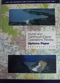
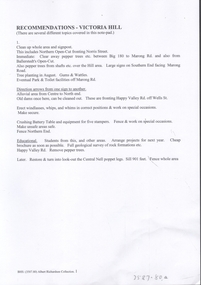
Book - Hume and Dartmouth Dams : Operations Review Options Paper, Hume and Dartmouth Dams Operations Review Reference Panel, 1998
In December 1996 the Murray-Darling Basin Ministerial Council agreed that the way in which Hume and Dartmouth Dams are operated should be reviewed. This options paper is the result of the review to November 1998. It describes the issues that have been identified as needing attention, the way in which the panel has gone about its task, the tensions that arise because of competing objectives for managing the regulated Murray, and possible improvements and changes to the balance between competing objectives. This paper was submitted to the interested stakeholders and the public for feedback.non-fictionIn December 1996 the Murray-Darling Basin Ministerial Council agreed that the way in which Hume and Dartmouth Dams are operated should be reviewed. This options paper is the result of the review to November 1998. It describes the issues that have been identified as needing attention, the way in which the panel has gone about its task, the tensions that arise because of competing objectives for managing the regulated Murray, and possible improvements and changes to the balance between competing objectives. This paper was submitted to the interested stakeholders and the public for feedback.hume reservoir, dartmouth dam, murray-darling basin, water management -
 Wodonga & District Historical Society Inc
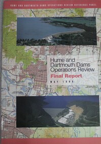
Book - Hume and Dartmouth Dams : Operations Review Final Report and Recommendations, Hume and Dartmouth Dams Operations Review Reference Panel, May 1999
During 1997 and 1998, the Hume and Dartmouth Dams Operations Review Reference Panel has undertaken a broadly based review of the way in which these two major water storages were operated. The Panel’s terms of reference were essentially to consider how the operating rules might be amended to better address the competing objectives of water supply, environmental enhancement and flood mitigation. This report includes summaries of feedback considered by the reference panel as well as its final recommendations.non-fictionDuring 1997 and 1998, the Hume and Dartmouth Dams Operations Review Reference Panel has undertaken a broadly based review of the way in which these two major water storages were operated. The Panel’s terms of reference were essentially to consider how the operating rules might be amended to better address the competing objectives of water supply, environmental enhancement and flood mitigation. This report includes summaries of feedback considered by the reference panel as well as its final recommendations.hume reservoir nsw, dartmouth dam victoria, water management -
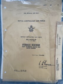
 Moorabbin Air Museum
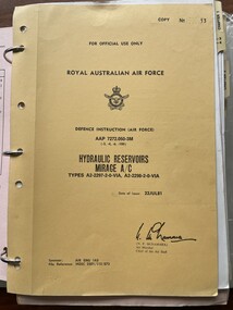
Manual (item) - (SP) AAP 7272.050-3M Mirage Hydraulic Reservoirs Types A2-2297-2-0-V1A,A2-2298-2-0V1A
-
 University of Melbourne, Burnley Campus Archives
Newspaper - Newspaper Cutting, The Leader, Horticultural Notes, 1893
Copy of article in "The Leader" (Melbourne) on 7 January, 1893. Yan Yean water supplied to Burnley Gardens.the leader, yan yean, reservoir, irrigation, burnley gardens -
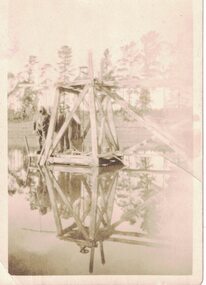 Linton and District Historical Society Inc
Photograph, Diver at Linton Reservoir, 1927, 1927
Small black and white image of a diver standing on a wooden structure over a body of water. (See also Registration no. 1849).divers, linton reservoir -
 Moorabbin Air Museum
Manual (Item) - (SP) AAP 7272.012-3M Hydraulic reservoir parts A2373 A23739
-
Healesville Sanctuary Heritage Centre
Newspaper - Cutting, Yarra Valley news, Sanctuary Lake shows "wonderful foresight", 12 March 1968
Report of speech by Mr Borthwick (Minister for Water Supply) at opening of the coranderrk reservoir.photocopynon-fictionReport of speech by Mr Borthwick (Minister for Water Supply) at opening of the coranderrk reservoir. 1960s -
 Bendigo Historical Society Inc.
Document - VICTORIA HILL - THE BENDIGO DIGGINGS, PRELIMINARY DRAFT FOR BROCHURE
BHS CollectionNine typed pages of notes on a preliminary draft for a brochure on the Bendigo Diggings. First part is the objective which is to preserve the mining history and to have exhibits in the places they were used, e.g. quartz mining machinery exhibited in a quartz mining area, not on an alluvial field. Part B is historical notes on the area. Part C is the Site - Victoria Hill area. Part D is Stage One which consists of carpark area, technological museum, restaurant, mineral haulage line, picnic ground, earthworks and planting over the area. Part E is Stage Two which will consist of the open-air exhibits, in the area surrounded by the mineral haulage line, and the Central Nell Gwynne mine on the west side of the site. Part F is Stage Three which will consist of the winery, the steam tram track, the lake, the wildlife sanctuary and various buildings associated with gold mining. Part G is Costing with the prices to be filled in. Parts H and I are the Appeal and the Committee. Details to be filled in. Notes prepared by Albert Richardson.mining, marketing, victoria hill, victoria hill, the bendigo diggings - preliminary draft for brochure, aust national travel association, tullamarine jetport, emu bottom homestead, kyneton historical museum, chinese joss house, eaglehawk museum, whipstick scrub, cairn curran reservoir, castelmaine historical museum and market hall, national trust, ballarat hiatorical park, echuca's hopwood gardens, swan hill folk museum, gibson's mount alexander no 2 squatting run, captain brown, chief commissioner wright, hustler's reef, thomas hustler, mining board, drainage of reefs act 1862, first world war, bendigo amalgamated goldfields, second world war, sandhurst, w c vahland, battery trams, horse trams, steam trams, electric trams, central nell gwynne mine, theodore ballerstadt, george lansell, new chum hill, ballerstadt's open cut, 180 mine, new chum syncline battery, william rae, victoria quartz, wittscheibe's 'jeweller's shop', luffsman and sterry, gold mines hotel, adventure, bendigo and district tourist association, bendigo city council, bendigo branch of the royal historical society of victoria, professor brian lewis, school of architecture and building at the university of melbourne, taylor horsfield, lord robert cecil, south australian gold commissioner -
University of Melbourne, Burnley Campus Archives
Plan, Merri Creek Management Committee Base Map, c. 1990
(1) 2 sets Base Maps Scale 1:5000 MCMC. (2.) 2 sets Merri Creek remnant vegetation Scale 1:5000.merri creek, management plan, northcote, coburg, reservoir, fawkner, thornbury, remnant vegetation -
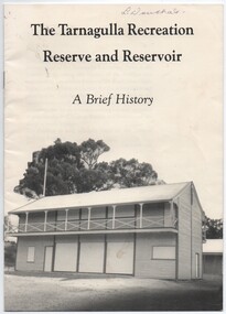 Tarnagulla History Archive
Booklet, Tarnagulla Recreation Reserve and Reservoir, 1990
-
 Ballarat Heritage Services
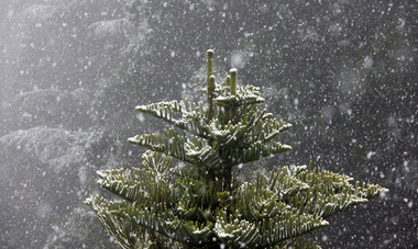
Photograph - Digital photographs, L.J. Gervasoni, Snow at the Wombat Hill Botanic Gardens, Daylesford, c2012-2016
The Daylesford Botanic Gardens are of historic, scientific (botanic), and aesthetic significance to the State of Victoria. The Daylesford Botanic Gardens are historically significant as a fine example of a regional botanic garden demonstrating the typical characteristics of a carriage drive, informal park layout, decorative structures and works such as the memorial tower, conservatory, rotunda, cascade and fernery, which contrasts with the open lawns planted with specimen trees, areas of intensive horticultural interest and close proximity to a township developed during the mid to late nineteenth century. The Daylesford Botanic Gardens are historically significant for the design input by noted landscape designer William Sangster, and for the survival of his 1884 plan, which is a rare example of a plan from this prolific garden designer. The Daylesford Botanic Gardens are of scientific (botanic) significance for the extensive conifer collection and cool climate plants. The Gardens contain an outstanding collection of conifers and other mature trees, many of which were donated by renowned botanist Ferdinand von Mueller. Significant trees include Pinus ponderosa (Western Yellow Pine), Pinus coulteri (Big Cone Pine), twoAbies nordmanniana (Caucasian Fir), Abies pinsapo, (Spanish Fir) and a Cedrus atlantica f. glauca(Blue Atlas Cedar), Pinus wallichiana (Bhutan Pine), Pinus pinaster (Maritime Pine), Sequoiadendron giganteum (Giant Redwood), (Monkey Puzzle) and Aesculus hippocastanum (Horse Chestnut), many the largest or finest examples in Victoria. Other outstanding trees include a Tilia cordata (Small-leaved European Linden), a row of Cupressus lusitanica (Mexican cypress), a Quercus robur (English Oak) planted in 1863, avenues of Dutch Elms and a rare Quercus leucotrichophora (Himalayan Oak). The Daylesford Botanic Gardens are of aesthetic significance as a rare example of a botanic garden spectacularly sited on an extinct volcanic cone which allows a panoramic view, aided by the 1938 Pioneers’ Memorial Tower, as well as vistas within and out of the gardens and from the township to the gardens. As the most prominent local landmark, the Garden’s vertical dominance in the landscape provides a dark contrast to the elms avenues, oaks and other deciduous species. (Heritage Victoria Register, )Digital imagesdaylesford, snow, weather, climate, winter, daylesford botanic gardens, botanic gardens, wombat hill, wombat hill botanic gardens, pinetum, trees, reservoir -
 Tarnagulla History Archive
Booklet: The Tarnagulla Recreation Reserve and Reservoir, A Brief History
-
 Greensborough Historical Society
Book - Annual Report, Diamond Valley Football League, Diamond Valley Football League. Annual Report and Balance Sheet. Season 1967, 15/03/1965
A complete record of the DVFL season 1967, includes financial report, description of events, membership, teams, scores from the seasons games and winners of best and fairest awards for all divisions and age groups. including black and white photos. In 1967 the Division 1 Premiers were Greensborough Football Club.This annual report covers many teams from within the Diamond Valley area. Includes junior and senior teams.Foolscap size book. 50 pages, printed on single and double sided of pages . Larger buff cover with black text and. Includes typed tables and black and white photosaustralian rules football, greensborough football club, diamond valley football league, dvfl, northern football league, nfl, northern football netball league, nfnl, reservoir lakeside football club -
 Greensborough Historical Society
Book - Annual Report, Diamond Valley Football League, Diamond Valley Football League. Annual Report and Balance Sheet. Season 1968, 15/03/1965
A complete record of the DVFL season 1968, includes financial report, description of events, membership, teams, scores from the seasons games and winners of best and fairest awards for all divisions and age groups. including black and white photos. In 1968 the Division 1 Premiers were Templestowe Football Club.This annual report covers many teams from within the Diamond Valley area. Includes junior and senior teams.Foolscap size book. 53 pages, printed on single sides of pages . Larger blue cover with black text and. Includes typed tables and black and white photosaustralian rules football, greensborough football club, diamond valley football league, dvfl, northern football league, nfl, northern football netball league, nfnl, reservoir lakeside football club -
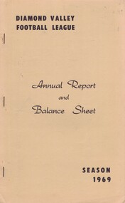 Greensborough Historical Society
Book - Annual Report, Diamond Valley Football League, Diamond Valley Football League. Annual Report and Balance Sheet. Season 1969, 15/03/1965
A complete record of the DVFL season 1969, includes financial report, description of events, membership, teams, scores from the seasons games and winners of best and fairest awards for all divisions and age groups. including black and white photos. In 1969 the Division 1 Premiers were Eltham Football Club.This annual report covers many teams from within the Diamond Valley area. Includes junior and senior teams.Foolscap size book. 53 pages, printed on single sides of pages . Larger buff cover with black text and. Includes typed tables and black and white photosaustralian rules football, greensborough football club, diamond valley football league, dvfl, northern football league, nfl, northern football netball league, nfnl, reservoir lakeside football club -
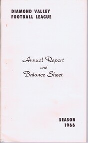 Greensborough Historical Society
Book - Annual Report, Diamond Valley Football League, Diamond Valley Football League. Annual Report and Balance Sheet. Season 1966, 15/03/1965
A complete record of the DVFL season 1966, includes financial report, description of events, membership, teams, scores from the seasons games and winners of best and fairest awards for all divisions and age groups. In 1966 the Division 1 Premiers were Greensborough Football Club.This annual report covers many teams from within the Diamond Valley area. Includes junior and senior teams.Foolscap size book. 45 pages, printed on single sides of page . Larger buff cover with black text and. Includes typed tables. australian rules football, greensborough football club, diamond valley football league, dvfl, northern football league, nfl, northern football netball league, nfnl, reservoir lakeside football club -
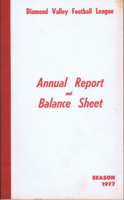 Greensborough Historical Society
Book - Annual Report, Diamond Valley Football League, Diamond Valley Football League. Annual Report and Balance Sheet. Season 1977, 1977
A complete record of the DVFL season 1977, includes financial report, description of events, membership, teams, scores from the seasons games and winners of best and fairest awards for all divisions and age groups. including black and white photos. In 1977 the Division 1 Premiers were Reservpor Lakeside Football Club.This annual report covers many teams from within the Diamond Valley area. Includes junior and senior teams.Foolscap size book. 63 pages, printed on single sides of pages . Larger buff cover with black text and includes typed tables and black and white photosaustralian rules football, greensborough football club, diamond valley football league, dvfl, northern football league, nfl, northern football netball league, nfnl, reservoir lakeside football club -
 Darebin Art Collection
Artwork, other, Brian Scott, Rec Art. THE RETURN OF THE DODO RECART PROJECT (A65601) and Reservoir Recovery Depot Outlook Environmental (A65601), 2009
Rec Art is a public art project that utilised only materials discovered at the Resource Recovery Centre.5 metre long x 1.8 metre high collage made of cut & assembled recycled metal signage. -
 Darebin Art Collection
Painting, Sid Cross, Blue Moon Over Reservoir, 2013
reservoir -
 Darebin Art Collection
Drawing, Nick Stella, Reservoir Boy: a sketched portrait of Barry Dickins with 'The Billy Boy' in mind, 2011
-
 Bendigo Historical Society Inc.
Document - VICTORIA HILL - RECOMMENDATIONS FOR VICTORIA HILL
BHS CollectionHandwritten notes on recommendations for cleaning up and signposting Victoria Hill. Also contains list of photos from the Bendigonian of 1899. List of photos: Shamrock Mine, Undershot Water Wheel at Diamond Hill for Phillips Crushing Battery. Mr. Ballerstedt's Crushing Battery at Victoria Hill, Thompson's Foundry at Castlemaine, Machinery made for Bendigo Mines, Air Compressor at Shenandoah Mine, Winding Engine at Koch's Pioneer Mine, Poppet Legs at Koch's Pioneer Mine, Air Compressor at New Chum Railway Mine, Fortune Hustlers G M Co Bendigo View of Mine, Winding Plant and Afternoon Shift and Underground Work in the New Chum Railway. Also mentioned are notes on Machinery made by Thompsons. Also, a carbon copy of Annual Report to Bendigo Branch Royal Historical Society, Victoria 1/7/71. Mentioned in the Report are: Historical Ball, The Central Deborah, Victoria Hill, Tours and Society Business. Albert Richardson document?document, victoria hill, recommendations for victoria hill, north old chum, ballerstedt's rich 24 yard claim, floyds battery lansell's big 180, the bendigonian 26/1/1899, 2/2/1899, 20/4/1899, 11/5/1899, 10/8/1899, 14/9/1899, shamrock mine, undershot waterwheel at diamond hill, phillips crushing battery, mr ballerstedt's crushing battery, thompson's foundry, shenandoah mine, koch's pioneer mine, new chum railway mine, fortuna hustlers g m co bendigo, new chum railway, st mungo lady barkly, catherine reef, new moon, rae's open cut, old court house eaglehawk, police barracks, vic wodetzki, joss house, central deborah, central nell gwynne, mr harold curnow, bendigo branch royal historical society victoria, mrs kingerlee, felicity kingerlee, mr h biggs, city council, rotary club of bendigo south, white hills cemetry, chinese joss house, bendigo pottery, mr derham, reservoir high, princess theatre, a n a hall, mr hattam, col. sprenger, survey corps, a richardson -
 Narre Warren and District Family History Group
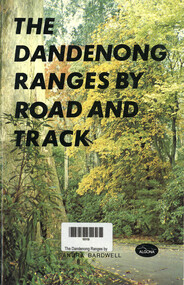
Book, Sandra Bardwell, The Dandenong Ranges by Road and Track, 1981
Tour routes in the Dandenong Ranges, including maps.64 p.; 22 cmnon-fictionTour routes in the Dandenong Ranges, including maps.dandenong ranges, tourism, cardinia reservoir, emerald lake park, aura vale lake, crystal brook park, bimbimbie wildlife park, guidebook -
 Bendigo Historical Society Inc.
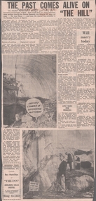
Newspaper - VICTORIA HILL - VICTORIA HILL NEWSPAPER ARTICLE
Two copies of newspaper articles titled ''The Past Comes Alive on 'The Hill'' from the Bendigo Advertiser dated 3/7/1971. Some history, a guided tour by two busloads of students and some plans are mentioned in the article. There are also two photos in the article. In one photo three Rotarians of Bendigo South, Mr. Vic Wodetski, Mr. Jack Bright and Mr. A. E. Richardson are inspecting some of the concentric rings of iron oxide and the quartz spur running through the centre of the outcrop on Victoria Hill. In the other photo Mr. jack Bright is looking at the natural curves of colour in the stone of Victoria Hill.newspaper, bendigo advertiser, victoria hill, victoria hill newspaper article, central deborah, victoria hill open cut, joss house, bendigo potteries, mr a e richardson, bendigo historical society, mr j hattam, reservoir high school, mr w j derham, rotary club of bendigo south, bendigo and district tourist association, victoria quartz mine, george lansell's big 180, theodore ballerstedt, goldmines hotel -
 Bendigo Historical Society Inc.
Document - Black and white laminated photo of flow of water from Lake Eppalock. 1964
John Perry Collection. Laminated copy of photo of crowd watching flow of water from the opened valve at the wall of Lake Eppalock during its commissioning. March, 1964. Lake Eppalock was created by flooding to town of Wild Duck. The dam was built by the State Rivers and Water Supply Commission of Victoria. The dam wall height is 45 metres (148 ft) and the main embankment is 1,041 metres (3,415 ft) long. At 100% capacity the dam wall was designed to hold back 304,651 megalitres (6.7014×10¹⁰ imp gal; 8.0480×10¹⁰ US gal) of water. The surface area of Lake Eppalock is 3,011 hectares (7,440 acres) and the catchment area is 2,124 square kilometres (820 sq mi). The controlled spillway is capable of discharging 8,040 cubic metres per second (284,000 cu ft/s). Lake Eppalock supplies both stock and domestic water to the Campaspe irrigation district. It also serves as a water supply to Bendigo and Heathcote and, in more recent times, Ballarat. The lake is a major attraction for those engaging in watersports, with a number of tourist parks and accommodation facilities available. Permissible activities on the lake include high-speed boating, water skiing, sailing, canoeing, fishing and swimming. The lake's water levels were low for approximately eight years between 2002 and 2010 during a prolonged drought, which restricted the amount of recreational activity until rainfall in the latter half of 2010 returned the lake to 100 percent capacity. Built between 1961 and 1964, Lake Eppalock remains the only water storage on the Campaspe River system.water, dam, reservoir, eppalock, wild duck -
 Bendigo Historical Society Inc.
Map - Map of Lake Eppalock shoreline when empty
John Perry Collection. Laminated copy of map detailing Lake Eppalock shoreline when empty. Circa 1951. Has colored highlighter lines following roads leading to lake shoreline and various inundated old roads and tracks on lakebed. The dam was built by the State Rivers and Water Supply Commission of Victoria. The dam wall height is 45 metres (148 ft) and the main embankment is 1,041 metres (3,415 ft) long. At 100% capacity the dam wall was designed to hold back 304,651 megalitres (6.7014×10¹⁰ imp gal; 8.0480×10¹⁰ US gal) of water. The surface area of Lake Eppalock is 3,011 hectares (7,440 acres) and the catchment area is 2,124 square kilometres (820 sq mi). The controlled spillway is capable of discharging 8,040 cubic metres per second (284,000 cu ft/s). Lake Eppalock supplies both stock and domestic water to the Campaspe irrigation district. It also serves as a water supply to Bendigo and Heathcote and, in more recent times, Ballarat. The lake is a major attraction for those engaging in watersports, with a number of tourist parks and accommodation facilities available. Permissible activities on the lake include high-speed boating, water skiing, sailing, canoeing, fishing and swimming. The lake's water levels were low for approximately eight years between 2002 and 2010 during a prolonged drought, which restricted the amount of recreational activity until rainfall in the latter half of 2010 returned the lake to 100 percent capacity. Built between 1961 and 1964, Lake Eppalock remains the only water storage on the Campaspe River system.map, eppalock, reservoir, lake, water -
 Bendigo Historical Society Inc.
Map - Laminated map of Lake Eppalock at full capacity
John Perry Collection. Laminated copy of map of Lake Eppalock at full capacity. Had highlighter markings of old roads which appear to be still in use. The dam was built by the State Rivers and Water Supply Commission of Victoria. The dam wall height is 45 metres (148 ft) and the main embankment is 1,041 metres (3,415 ft) long. At 100% capacity the dam wall was designed to hold back 304,651 megalitres (6.7014×10¹⁰ imp gal; 8.0480×10¹⁰ US gal) of water. The surface area of Lake Eppalock is 3,011 hectares (7,440 acres) and the catchment area is 2,124 square kilometres (820 sq mi). The controlled spillway is capable of discharging 8,040 cubic metres per second (284,000 cu ft/s). Lake Eppalock supplies both stock and domestic water to the Campaspe irrigation district. It also serves as a water supply to Bendigo and Heathcote and, in more recent times, Ballarat. The lake is a major attraction for those engaging in watersports, with a number of tourist parks and accommodation facilities available. Permissible activities on the lake include high-speed boating, water skiing, sailing, canoeing, fishing and swimming. The lake's water levels were low for approximately eight years between 2002 and 2010 during a prolonged drought, which restricted the amount of recreational activity until rainfall in the latter half of 2010 returned the lake to 100 percent capacity. Built between 1961 and 1964, Lake Eppalock remains the only water storage on the Campaspe River system.map, water, dam, reservoir, eppalock -
 Bendigo Historical Society Inc.
Map - Laminated worksheet - identification of inundated artifacts at Lake Eppalock
John Perry Collection. Laminated copy of worksheet identifying inundated artifacts at Lake Eppalock when at 10% capacity. The dam was built by the State Rivers and Water Supply Commission of Victoria. The dam wall height is 45 metres (148 ft) and the main embankment is 1,041 metres (3,415 ft) long. At 100% capacity the dam wall was designed to hold back 304,651 megalitres (6.7014×10¹⁰ imp gal; 8.0480×10¹⁰ US gal) of water. The surface area of Lake Eppalock is 3,011 hectares (7,440 acres) and the catchment area is 2,124 square kilometres (820 sq mi). The controlled spillway is capable of discharging 8,040 cubic metres per second (284,000 cu ft/s). Lake Eppalock supplies both stock and domestic water to the Campaspe irrigation district. It also serves as a water supply to Bendigo and Heathcote and, in more recent times, Ballarat. The lake is a major attraction for those engaging in watersports, with a number of tourist parks and accommodation facilities available. Permissible activities on the lake include high-speed boating, water skiing, sailing, canoeing, fishing and swimming. The lake's water levels were low for approximately eight years between 2002 and 2010 during a prolonged drought, which restricted the amount of recreational activity until rainfall in the latter half of 2010 returned the lake to 100 percent capacity. Built between 1961 and 1964, Lake Eppalock remains the only water storage on the Campaspe River system.map, artifacts, eppalock, reservoir -
 Bendigo Historical Society Inc.
Map - Black and white map pertaining to Lake Eppalock
John Perry Collection. Laminated copy of map pertaining to Lake Eppalock. Gives details of dwellings, bridges and ford crossings. The dam was built by the State Rivers and Water Supply Commission of Victoria. The dam wall height is 45 metres (148 ft) and the main embankment is 1,041 metres (3,415 ft) long. At 100% capacity the dam wall was designed to hold back 304,651 megalitres (6.7014×10¹⁰ imp gal; 8.0480×10¹⁰ US gal) of water. The surface area of Lake Eppalock is 3,011 hectares (7,440 acres) and the catchment area is 2,124 square kilometres (820 sq mi). The controlled spillway is capable of discharging 8,040 cubic metres per second (284,000 cu ft/s). Lake Eppalock supplies both stock and domestic water to the Campaspe irrigation district. It also serves as a water supply to Bendigo and Heathcote and, in more recent times, Ballarat. The lake is a major attraction for those engaging in watersports, with a number of tourist parks and accommodation facilities available. Permissible activities on the lake include high-speed boating, water skiing, sailing, canoeing, fishing and swimming. The lake's water levels were low for approximately eight years between 2002 and 2010 during a prolonged drought, which restricted the amount of recreational activity until rainfall in the latter half of 2010 returned the lake to 100 percent capacity. Built between 1961 and 1964, Lake Eppalock remains the only water storage on the Campaspe River system.eppalock, map, water, dam, reservoir -
 Bendigo Historical Society Inc.
Map - Map of overlay of lake Eppalock at full capacity. Map 'C'
John Perry collection. Map 'C'. Laminated map of overlay of Lake Eppalock at full capacity. Circa 1951. The dam was built by the State Rivers and Water Supply Commission of Victoria. The dam wall height is 45 metres (148 ft) and the main embankment is 1,041 metres (3,415 ft) long. At 100% capacity the dam wall was designed to hold back 304,651 megalitres (6.7014×10¹⁰ imp gal; 8.0480×10¹⁰ US gal) of water. The surface area of Lake Eppalock is 3,011 hectares (7,440 acres) and the catchment area is 2,124 square kilometres (820 sq mi). The controlled spillway is capable of discharging 8,040 cubic metres per second (284,000 cu ft/s). Lake Eppalock supplies both stock and domestic water to the Campaspe irrigation district. It also serves as a water supply to Bendigo and Heathcote and, in more recent times, Ballarat. The lake is a major attraction for those engaging in watersports, with a number of tourist parks and accommodation facilities available. Permissible activities on the lake include high-speed boating, water skiing, sailing, canoeing, fishing and swimming. The lake's water levels were low for approximately eight years between 2002 and 2010 during a prolonged drought, which restricted the amount of recreational activity until rainfall in the latter half of 2010 returned the lake to 100 percent capacity. Built between 1961 and 1964, Lake Eppalock remains the only water storage on the Campaspe River system.map, water, eppalock, dam, reservoir