Showing 1028 items matching "water river"
-
 Lakes Entrance Historical Society
Photograph - Johnsonville School, Lakes Post Newspaper, 1996
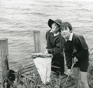
... the Tambo River as part of water watch program at primary school... jetty, collecting samples from the Tambo River as part of water ...Black and white photograph of two children Coban Duffy and Nicole Rijs with net on small jetty, collecting samples from the Tambo River as part of water watch program at primary school Johnsonville Victoriaschools, students, activities -
 Lakes Entrance Historical Society
Photograph - Johnsonville School, Lakes Post Newspaper, 1996
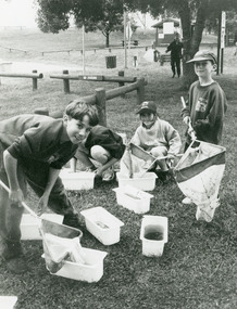
Black and white photograph of small group of children one named as Scott Froud on bank of Tambo River, with nets and buckets of water, samples collected for the water watch program at primary school Johnsonville Victoriaschools, activities -
 Bacchus Marsh & District Historical Society
Map, General Plan for Water Supply Works, Shire of Bacchus Marsh 1887
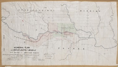
Debate about water supply and its planning and development took place in the Bacchus Marsh region from the 1850s through into the twentieth century. This plan was part of documentation to support an application for an additional loan of money from the Ministry of Water Supply to the Bacchus Marsh Shire Water Supply Trust. The plan includes the route of a proposed water channel in the Parwan area, and other features of water supply infrastructure such as the location of standpipes and gates are also shown on the plan.A single page paper map showing a general plan for the supply of water in the Bacchus Marsh area.The plan shows the route of the 'Main Channel' near the Werribee River and a proposed route for a Parwan Channel. The location of 'Dryden's House' near the Werribee River is also shown and the locations of land held by T. (Tom) Oliver and the Racecourse Reserve in Maddingley. Scale 40 chains to 1 inch. The plan is signed by Bacchus Marsh Shire Engineer, W.E. Standfield. The map is pasted into a bound volume containing 76 maps or plans in total. High resolution digital image stored on BMDHS computer network. General Plan of Water Supply Works in the Shire of Bacchus Marsh. Accompanying application for 2nd additional Loan. Original Waterworks district. Additional area. W.E. Standfield, 30/8/87.water supply, water supply maps, water supply bacchus marsh, irrigation, bacchus marsh victoria maps -
 Wodonga & District Historical Society Inc
Photograph - Bethanga Bridge
The Bethanga Bridge was built between 1927 and 1930 as a joint venture between Victoria and New South Wales and was a key element of the River Murray Waters Agreement. It consists of nine spans of 82 metres long. Each span is supported between double reinforced concrete pylons and a riveted steel camel back Pratt truss. The overall span of the bridge is a length of 752 metres. It was completed in 1929 at a cost of £194,000. The road deck was initially constructed from timber but was replaced in 1961 with a concrete waffle slab deck 7.7metres wide. In 1961 the bridge deck and truss structure were raised 300 millimetres to allow for the enlargement of the lake. The bridge was designed in NSW by road engineer Percy Alan and the trusses were built by the Charles Ruwolt Pty. Ltd. Charles Ruwolt Pty. Ltd. was originally established by Charles Ruwolt as a foundry at Wangaratta in 1902 and transferred its operations to Richmond, Melbourne in 1914. By 1938 it had become one of the biggest engineering companies in Australia. After Charles Ruwolt’s death in 1946, Vickers Ltd. acquired the company and in 1948 the firm became known as Vickers Ruwolt Pty. Ltd. Because of the Bethanga Bridge’s unique location, over the waters of a dam with the border running down the centre of the body of water, the Bethanga Bridge is the only built structure shared by both Victoria and New South Wales. As the border of New South Wales aligns with the southern bank of the Murray River all of the other bridges along its length are deemed to be in New South Wales. The Bethanga Bridge is listed on both the New South Wales State Heritage Register and the Victorian Heritage Database. In 2015 the Bethanga Bridge was nominated for a heritage award by the Institution of Engineering Australia.These images are significant because they document the construction of a bridge which links Victoria and New South Wales and has been recognised for its historical, technical and engineering significance.A collection of photos documenting the construction of the Bethanga Bridge which links the States of Victoria and New South Wales as part of the construction of the Hume Dam .bethanga bridge, hume dam constuction, charles ruwolt, percy allan engineer -
 Lakes Entrance Historical Society
Photograph - S.S. Tambo, 1885 c
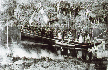
Black and white photograph showing S S Tambo, trail trip 1882 on Tambo River shows large crowd on boat, bunting flying from mast, two small row boats either side. Thick bush on far bank. Post and rail fence going into the water lower right hand corner. Camp oven or boiler and camp fire lower left hand corner. Tambo Upper Victoriaboats and boating, tourism, waterways -
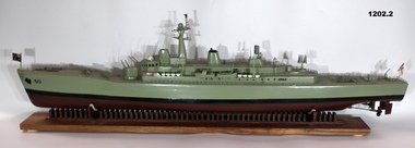 Bendigo Military Museum
Craft - MODEL & BASE, HMAS SWAN
Model of HMAS Swan built by Shipwright Charles Axiak. Original ship construction in Melbourne and entered service 1970. Was a River Class Destroyer. Model maker worked in British Dockyards during WW2 and emigrated to Australia in 1955. He worked in Williamstown dockyards involved with construction of the Swan,1. Model of River Class Destroyer. green in colour from water line. Black line and brown at bottom. Small Australian flag at front and naval flag at back. 2. Wooden stand, tailor made to hold the model of the 'Swan'. Brown in colour with long flat board and separate pieces of wood embedded in the base to make the cradle. High points of cradle covered by some white felt to protect boat. Bottom of stand has felt studs."50" painted at front of boat.ships model, hmas swan -
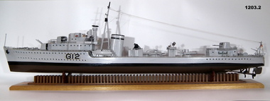 Bendigo Military Museum
Craft - MODEL & BASE, HMS KASHMIR
Model of HMS Kashmir built by Shipwright Charles Axiak. He originally trained and worked in British dockyards during WW2. Emigrated to Australia in 1955 and finished working in Williamstown dockyards building the River Class Destroyers K Class Destroyers built in UK in 1930's.1. Model of K-class Destroyer UK. Grey in colour above water line and brown below water line with black stripe dividing. Model has complete details of deck, guns and screws. 2. Wooden stand tailor made to hold the model of the ship. Brown in colour with long flat board. Small individual pieces of wood glued to the top to form the cradle for the boat. Also 4 felt footings at bottom of cradle.G.12 painted on side.ships model, hms kashmir -
 Bacchus Marsh & District Historical Society
Map, O'Hagan v Shire of Bacchus Marsh, Allotment 5, Sec 16, Parish of Korkuperrimul
The purpose for this map being created or the date when it was made has not been established. It appears to be documentation relating to a legal dispute by a landowner named O'Hagan and the Shire of Bacchus Marsh. Features identified on the map are allotment 5, section 16, Parish of Korkuperrimul, a 'cultivation paddock', a section of the Werribee River, the path of a section of a 'Main Channel', and a barrier or filled in section across the Werribee River called 'Lee's Filling'. The O'Hagan is likely to be Patrick O'Hagan, 1829-1914 who arrived in Bacchus Marsh in 1864 and was a prominent citizen and landowner in the area for many years until his death in 1914.Single page map showing allotment 5, section 16 in the Parish of Korkuperrimul, Scale 4 chains to inch. Part of a set of maps which are pasted into a bound volume containing 76 maps or plans in total. High resolution digital image stored on BMDHS computer network. Stamped: Munzt, Bace and Muntz, Civil Engineers and Licensed Surveyors , 388 Collins Streetbacchus marsh victoria maps, water supply structures and establishments, watercourses -
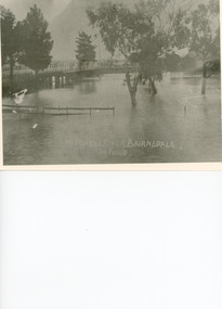 Lakes Entrance Historical Society
Photograph - Floods, 1919
Black and white photograph showing Mitchell River in flood at the old highway bridge at east end of town. Roof of Imperial Hotel in background at far end of bridge, trees and fences under water in foreground. Bairnsdale Victoriabridges, flooding -
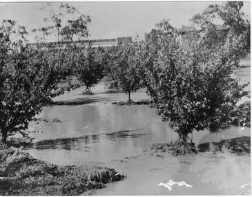 University of Melbourne, Burnley Campus Archives
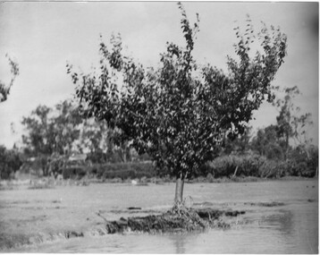
Photograph - Black and white print, Orchard in Flood, 1934
Black and white photograph. Orchard in flood: shows fruit trees standing in water.On reverse, "Orchard Yarra River in flood Dec 1934."orchard, yarra river, floods, 1934, fruit trees -
 University of Melbourne, Burnley Campus Archives
Photograph - Black and white print, Orchard After Flood, 1934
Black and white photograph. Orchard after flood: shows single fruit tree surrounded by water. Enlargement.orchard, yarra river, floods, 1934, fruit tree -
 Federation University Historical Collection
Book, Final recommendations Ballarat Study Area Land Conservation Council, Victoria, 1982, 1982
... bulldog ballarat common wildlife water timber flora rivers geology ...Yellow soft covered report of 95 pages . The contents of the report include: Parks, reference areas, wildlife reserves, water production, harwood production, softwood production, flora Reserves and Flora and Fauna reserves, bushland reserves, historic area and reserves, rivers and streams, Roadside conservation and Highway parks, Education areas and School Plantations, Lake Reserves, geological reserves, recreation, scenic reserves, agriculture, mineral and stone production, utilities and survey, township land, Uncommitted Land, military training, other reserves and public land. Maps include: The Study area 1: 250 000 Supplementary Mapsland conservation authority, ballarat, endowment plantations, pine plantations, langi ghiran state park, mount buangor state park, enfield state park, ballarat-creswick regional park, rossbridge, black lake, flax mill swamp, dereel lagoon, lake bolac, lake wongan, langi ghiran reservoir, gong gong reservoir, pincotts reservoir, beales reservoir, wilsons reservoir, moorabool reservoir, korweinguboora, korweinguborra reservoir, learmonth bores, sago hill, illabarook reservoir, ballarat water commission, dunneworthy, mount cole, mont lonarch, ben major, waterloo, trawalla, linton, ross creek, canadian, shepherds flat, lal lal, mount doran, raglan, chute, carngham, buninyong, watsons hill, enfield, cape clear, illabrook, rokewood junction, mount warrenheip, nerrina, jubilee, golden stream, australasian deep lead mine, happy valley school, piggoreet, berringa, bulldog, ballarat common, wildlife, water, timber, flora, rivers, geology, agriculture, warrenheip, biodiversity -
 Bendigo Historical Society Inc.
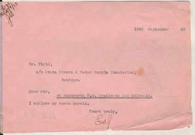
Document - MISS G ALICE JONES COLLECTION: ACCOUNT
... Rivers & Water Supply Commission Rushworth G.M. Syndicate ...Pink paper dated 19th September 33. Note to Mr. Field from GAJ mentioning she encloses her costs herein. "R5?9 del20/9/33 JW" written in the top left corner.the miss g alice jones collection - account, mr field, state rivers & water supply commission, rushworth g.m. syndicate and mcdonald -
 Eltham District Historical Society Inc
Photograph - Digital Photograph, Marguerite Marshall, Smith Dam, Karingal Drive, Eltham, 19 September 2006
The dam at the entrance to the Nerreman Gateway in Eltham was built according to an internationally acclaimed theory developed by the builder's father. In 1920, Victorian engineer B.A. Smith was awarded the American Society of Civil Engineers J. James R. Cross Gold Medal for his Technical Paper titled 'Arched Dams'. It was the first time this medal had been awarded outside the United States. The concrete arched dam across the Eltham West Drain was built in 1940 by B.A. Smith's son and engineer, D. B. (Bernie) Smith to water the 24 acre (9.75 ha) hobby farm owned by himself and new wife, Isa Smith. Upon completion of the dam a pump-house was constructed beside the creek but before the water could be pumped up the hill they had to dig a trench and lay 500m of 100mm water main to an elevated holding tank. The Smiths made the pump-house their home for several years until they constructed their home at the top of the hill overlooking Eltham and views extending to Kinglake. Following Bernie's death in 1983, Nerreman Park was subdivided between 1993 and 1995. Gordon Ford designed the landscaping and the pump-house was demolished. Covered under Heritage Overlay, Nillumbik Planning Scheme. Published: Nillumbik Now and Then / Marguerite Marshall 2008; photographs Alan King with Marguerite Marshall.; p137 The dam at the entrance to the Nerreman Gateway in Eltham, was built according to an internationally acclaimed theory developed by the builder’s father. In 1920, Victorian engineer B A Smith was awarded the American Society of Civil Engineers J. James R. Croes Gold Medal, for his Technical Paper titled Arched Dams. It was the first time this medal had been awarded outside America. An international example of the application of Smith’s work can be found in the design of the Hoover Dam on the Colorado River, Nevada, USA. Built between 1930 and 1936, it is recognised by the ASCE as one of ‘America’s Seven Modern Civil Engineering Wonders’.1 The concrete arched dam across the Eltham West Drain was built by B A Smith’s son and engineer, D B (Bernie) Smith. Bernie’s dam followed his father’s theory, having a curvature that takes maximum advantage of concrete’s great strength in compression. The water load is carried into the abutments because of this curvature, which permits a wall thickness of only 225 millimetres thick at its crest, despite the dam’s capacity of more than 4.5 megalitres. The Eltham dam was designed to water the 24 acre (9.75 ha) hobby farm belonging to newly married couple Bernie and Isa Smith. Bernie, from Armadale, and Isa, from a farm at Tyntynder near Swan Hill, were attracted to the hilly topography and the creek running through the property. It extended from Ryans Road, Eltham, to Karingal Drive, Montmorency and was adjacent to Meruka Park. The Smiths named it Nerreman Park using the Aboriginal word Nerreman meaning ‘River Bend’ as their creek had a pronounced bend.2 In 1940 the first thing Bernie did was to build a dam, and with Isa’s help, a pump-house, to secure a water supply for their cattle, pigs, chickens, orchard and vegetable gardens. It was also available for the fire-plugs, which they placed all over the property in case of bushfire. The couple built the pump-house beside the creek and installed a Tange three-plunger pump, which had originally supplied the City of Wodonga with water. But before the Smiths could pump water up the hill from the dam they had to dig a trench and lay about 550 yards (500m) of a four-inch (100mm) water main up to an elevated holding tank. The trench was dug with a single furrow plough drawn by an old draught horse. Living in rough conditions did not deter the Smiths, who made the pump-house their home, where they still lived when their first child was born in 1944. They later built their home at the top of their property overlooking Eltham, with magnificent views to Kinglake, the Dandenong Ranges and Melbourne. From 1946 it took them almost 20 years to complete the 36-square house with its 12-foot (3.6m) high ceilings. Material for the concrete roof and walls faced with sandstone, was ripped out of the ground on their property by plough pulled by tandem Clydesdale horses. Isa was a strong woman – two days before their second child was born – she set three huge sandstone boulders in place in the bottom wall of the garage. She also mixed all the cement for the house. A collapsed kitchen wall did not discourage her from rebuilding it in a week, while her husband was away working in the country. She later recalled: ‘We stood back to admire this beautiful wall we’d built and while we were looking at it, it came tumbling down’.3 Following Bernie’s death in 1983, Nerreman Park was subdivided, between 1993 and 1995. Local Gordon Ford designed the landscaping and the pump-house was pulled down. But the dam remains as a reminder of exceptional engineering4 – and of a remarkable couple.This collection of almost 130 photos about places and people within the Shire of Nillumbik, an urban and rural municipality in Melbourne's north, contributes to an understanding of the history of the Shire. Published in 2008 immediately prior to the Black Saturday bushfires of February 7, 2009, it documents sites that were impacted, and in some cases destroyed by the fires. It includes photographs taken especially for the publication, creating a unique time capsule representing the Shire in the early 21st century. It remains the most recent comprehenesive publication devoted to the Shire's history connecting local residents to the past. nillumbik now and then (marshall-king) collection, eltham, karingal drive, smiths dam, bernie smith, gordon ford, isa smith, nerreman gateway, nerreman park estate, dams -
 Bendigo Historical Society Inc.
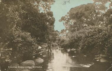
Postcard - Alice McGregor Postcard Collection, 1900 - 1920
Alice McGREGOR Born: 1908; unknown parents. Possibly adopted by the Salter family? Electoral Roll 1936: Highland Terrace Kangaroo Flat. Alice Mary Salter and William Robert Salter living together; presumed to be sister and brother. William Robert Salter was killed in a MVA in Bendigo in 1937 aged 26. In Victoria in 1938, Alice Mary Salter married James Thomas McGregor (born Victoria 1917, died Victoria 1983, buried Fawkner Cemetery) Lived: 1968; 22 Wade Street Golden Square Alice McGregor Died: 1999 aged 91 at Anne Caudle Centre, Bendigo Buried: Kangaroo Flat Cemetery See additional research. Postcard Album of Alice McGregor contained 86 post cards.Postcard Album of Alice McGregor containing 86 postcards. See 1400 Colour photo of the Erskine River, Lorne, Victoria Three figures fishing at the water's edge. Trees and shrubs growing on either bank. Addressed to Miss ? Stapleton, Arcade, Bendigo Sender - not decipherable Stamp dated 12 April 1905 postcard, collector, alice mcgregor -
 Bendigo Historical Society Inc.
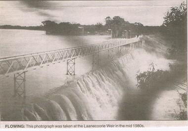
Newspaper - JENNY FOLEY COLLECTION: FLOWING
The Laanecoorie Weir on the Loddon River supplies both irrigation and domestic water. It was the second Victorian irrigation scheme after the Goulbourn. It was constructed 1889-1892 with the outlet valves installed in 1891.Bendigo Advertiser ''The way we were'' from 2003. Flowing: this photograph was taken at the Laanecoorie Weir in the mid 1980s. The clip is in a folder.newspaper, bendigo advertiser, the way we were -
 Merbein District Historical Society
Map, State Rivers & Water Supply Commission-Merbein Urban District n.d, unknown
... Rivers and Water Supply Commission Merbein township State Rivers ...state rivers and water supply commission, merbein township -
Merbein District Historical Society
Document, The Story of Merbein, 1909-1950s
... Arnold Willie Bennett Peter Lee Alex Bruce State Rivers and Water ...d.j. tulloch (author), cliffs white, h.w. hollis, james aif philpott, mr arnold, willie bennett, peter lee, alex bruce, state rivers and water supply commission, angus mccormick, yelta, merbein golf club, mrs e. spargo, merbein brass band, e.s. donaldson, f.a. deacon, william crosbie, e. fisher, j.h. hudson, c. bennett, w. adams, w.j. smith, e.s. collins, j.a. braidie, lake hawthorn, merbein train, mrs delahoy, c.j. sheridan, mrs delaney, mr bennett, picture theatres, post office, barney o'connor, dalmura, r.g. cameron, f.c. kane, myoora, h.g. lloyd, s.j. whiting, v. allen, r. allen, pioneer brick works, methodist church, methodist sunday school, h.c. lapthorne, merbein railway station, c. james, j.c. rose, n. treadwell, mrs wynne, miss troon, v. miss jarrett, miss e. bennett, miss cole, miss n. pearce, miss eva hollis, miss jean hollis, miss hazel hollis, miss kath hollis, mrs w.f. reeves, mrs r.m. voullaire, miss e. bannister, mr j. avery, mr l. holland, mr l.c. lapthorne, mr reeves, merbein public hall, mr j. worthington, merbein ana, mildura winery, research station, a.v. lyon, presbyterian church, s. thompson, a.s. lloyd, j.c. wishart, f. woods, e. smith, a.b. bruce, s. mcmeekin, finley fraser, a. fonder, e.w. wallis, james legge, gordon raff, g.l. hardie, p. murray, r.i. morris, james jones, v.f. hadleu, e. new, d.m. smith, charles weir, brigade fire, traders' association merbein, ratepayers' association merbein, p.v. appleby, a.j. chislett, w. bennett, d.w. peel, h. blaby, w. hazel, a.h. lee, w. grant, a.j. baldock, j. west, e. kelly, j.a. braidie, a.w. lee, j.h. russell, f. mckenzie, r.r. spence, p. swain, w.j. jones, i.w. heatherington, w.g. millhouse, e.w. smith, f.e.d. rankin, mr mcdonell, g. campaign, a. roots, friendly union of soldiers' wives and mothers, red cross society, merbein progress league, hugh a. leslie, a. hayles, j.p. power, j. davis, w.h. chaffey, f.j. walsh, a. roberts, d. richards, r.s. drury, a. robert, j.w. marrows, st john's church of england, r.b. davison, h.e. noltenius, g.e. menlove, st albans church of england - birdwoodton, mr wellington, progress association, elwood mead, merbein race course, rowing club, royal hall, j. lomax, f.j.p. pierson, c.h. foster, n. lumb, f.c. pierson., t. lumb, r. smith, w. quinsey, d. mctaggart, j. storer, l. mctaggart, j. walters, f.a. carmichael, n. smith, j.a. williams, d. walters, a. lever, l.u. alley -
Merbein District Historical Society
Newspaper, Sunraysia Daily - Merbein Golden Jubilee Feature (2 copies), 18 Aug.1959
... Merbein Rowing Club State Rivers & Water Supply Commission Merbein ...golden jubilee, merbein higher elementary school, land board, merbein cricket club, south merbein cricket club, merbein bowling club , merbein turf club, ana, mildura winery pty. ltd. (mildara), merbein victicultural research station, e.j. roberts, irymple packing company - merbein branch, mildura co-operative fruit company - merbein branch, merbein methodist church, merbein cwa, merbein baby health centre, birdwoodton soldier settlement, merbein rsl, nelson wellington (colonel), john mcleod, merbein guides, merbein rowing club, state rivers & water supply commission, merbein settlers progress association, big lizzie, women's welfare club, lake school, merbein dads association, commercial banking company of sydney ltd., murray valley horsemen's club -
Merbein District Historical Society
Photograph, Merbein Township- Looking east towards Pumping Station, 1936
... River Avenue (taken from Water Tower)...Merbein District Historical Society 36 Box St Merbein River ...river avenue (taken from water tower), chaffey park tennis courts -
Merbein District Historical Society
Administrative Record, Ledger, Irrigation Rate Book- Yelta, 1918-1919
... Blocks State Rivers and Water Supply Commission Yelta Ledger ...blocks, state rivers and water supply commission, yelta -
Merbein District Historical Society
Administrative Record, Ledger, Irrigation Rate Book- Yelta, 1919-1920
... Blocks State Rivers and Water Supply Commission Yelta Ledger ...blocks, state rivers and water supply commission, yelta -
Merbein District Historical Society
Administrative Record, Ledger, Irrigation Rate Book- Merbein, 1920-1921
... Rivers & Water Supply Commission Sunraysia Rural Water Authority ...state rivers & water supply commission, sunraysia rural water authority, water allocations - merbein, irrigators -
Merbein District Historical Society
Administrative Record, Ledger, Irrigation Rate Book- Yelta, 1920-1921
... Blocks State Rivers and Water Supply Commission Yelta Ledger ...blocks, state rivers and water supply commission, yelta -
Merbein District Historical Society
Administrative Record, Ledger, Irrigation Rate Book- Yelta, 1921-1922
... Blocks State Rivers and Water Supply Commission Yelta Ledger ...blocks, state rivers and water supply commission, yelta -
Merbein District Historical Society
Administrative Record, Ledger, Irrigation Rate Book- Yelta, 1923-1924
... Blocks State Rivers and Water Supply Commission Yelta Ledger ...blocks, state rivers and water supply commission, yelta -
Merbein District Historical Society
Administrative Record, Ledger, Irrigation Rate Book- Yelta, 1924-1925
... Blocks State Rivers and Water Supply Commission Yelta Ledger ...blocks, state rivers and water supply commission, yelta -
Merbein District Historical Society
Administrative Record, Ledger, Irrigation Rate Book- Yelta, 1925-1926
... Blocks State Rivers and Water Supply Commission Yelta Ledger ...blocks, state rivers and water supply commission, yelta -
Merbein District Historical Society
Administrative Record, Ledger, Irrigation Rate Book- Yelta, 1926-1927
... Blocks State Rivers and Water Supply Commission Yelta Ledger ...blocks, state rivers and water supply commission, yelta -
Merbein District Historical Society
Administrative Record, Ledger, Irrigation Rate Book- Yelta, 1927-1928
... Blocks State Rivers and Water Supply Commission Yelta Ledger ...blocks, state rivers and water supply commission, yelta