Showing 31762 items
matching south
-
 Tatura Irrigation & Wartime Camps Museum
Folder - survey maps
Maps of no 14 A, B, C and D internment camps and documents on Loveday Camp, South Australia. Donated by Gerhard Meinke concerning Loveday Camp. Brief outline of camps life, release and repatriation, list of deaths, of POW's and internees.Blue back clear plastic folder containing maps of No 14 camp and documents on Loveday Camp.gerhard meinke, loveday camp, camp 14, south australian internment camps, japanese internees -
 Hume City Civic Collection
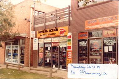
Photograph, 26/10/1980
The three brick shops were part of the later commercial development which emerged along O'Shanassy Street. These shops were built on the northern side of Brook Street. Earlier commercial development was confined to the south side of Brook Street.A coloured photograph of a street scape in O'Shanassy Street showing three shop fronts. At the time the photograph was taken the shops were occupied by Kilkenny Real Estate Agent, Camera Action and Heron Electrics. There is a roof top patio area above the camera shop and two treated pine rails are along the nature strip.o'shanassy street, sunbury, kilkenny real estate, camera action, heron electrics, george evans collection -
 Hume City Civic Collection
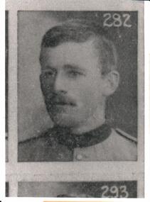
Photograph, c 1901
This is a photograph of Prtivate William Hanlen from Tullamarine No. 1160, 5th Victorian Mounted Rifles Contingent. he was one of several local enlistments for the Boer War in South Africa. In June 1901 he was listed as being dangerously illThis is a copy of a photograph of a soldier.Written on the back: PTE.W.S. HANDLENboer war, soldiers, uniforms, handlen, william, cossum, jeff, 5th mounted rifle contingent, george evans collection -
 National Wool Museum
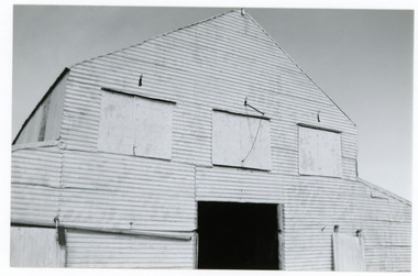
Photograph
Depicts Booyoolee Shed, which was built in 1856 and demolished in 1989. View of top of building. The three flaps could be opened to allow ventilation. Taken by John Bailey in South Australia at the request of Gael Shannon (former NWM employee). -
 National Wool Museum
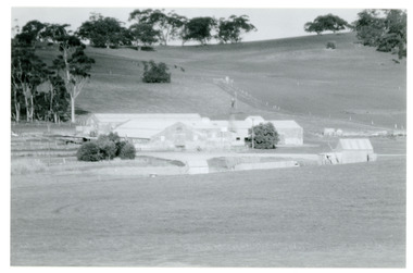
Photograph
Depicts Bungaree Shed, a big old store structure with the original part being commenced in 1842. View of buildings from north-west. Taken by John Bailey in South Australia at the request of Gael Shannon (former NWM employee). -
 National Wool Museum
Photograph
Depicts Bungaree Shed, a big old store structure with the original part being commenced in 1842. View of buildings from north/west. Taken by John Bailey in South Australia at the request of Gael Shannon (former NWM employee). -
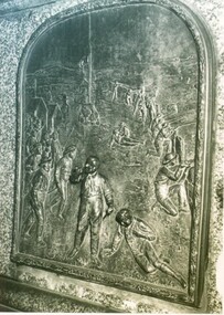 City of Ballarat Libraries
Photograph, Peter Lalor statue and reliefs
Peter Lalor statue and close up of bronze reliefs. Eureka Stockade relief on the south side and Lalor in Parliament on the north side of the statue. Located at the western end of the median strip where Dawson Street crosses Sturt Street.peter lalor, eureka stockade, statue, sturt street, dawson street, parliament -
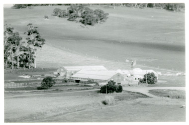
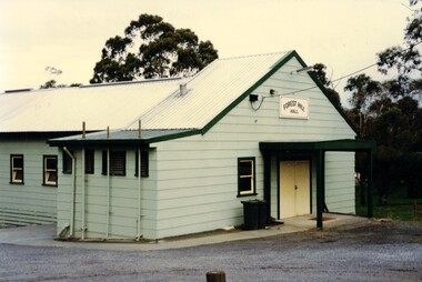 Whitehorse Historical Society Inc.
Photograph, Forest Hill Hall
The Forest Hill Hall was built before the 1960s and is situated on the South East side of the intersection of Canterbury and Springvale Rds.The hall seats 70 and can supply tables chairs and a stove. The floor is timber and there is a disability access. There are no parties allowedColoured photograph of a green building with a yellow door. Forest Hill Hall is printed on a board above the doorforest hill hall, halls -
Bialik College
Album (Item) - "Mikado", Bialik College, Theatre Production 199
1999 school musical production at Bialik College. Held at St Martins Youth Centre, South Yarra. Show dates August 20-31, September 1-2. Please contact [email protected] to request access to this record.1990s, bialik college, musical, theatre production, judaism -
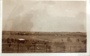 Kew Historical Society Inc
Photograph - Yarra Valley at Kew, 1918
During the nineteenth century, the land abutting the south side of the Yarra in Kew was devoted to dairy farming. In the twentieth century, before and after the construction of the Eastern Freeway, much of this low-lying area was used as golf courses and public parks.View of the farmland in the Yarra Valley at what is believed to be East Kew in 1918. Verso: "Willsmere / East Kew? / 1918"yarra river, yarra valley -
 Kew Historical Society Inc
Photograph - Yarra Valley at Kew, 1912
During the nineteenth century, the land abutting the south side of the Yarra in Kew was devoted to dairy farming. In the twentieth century, before and after the construction of the Eastern Freeway, much of this low-lying area was used as golf courses and public parks.Real-photo postcard of the farmland in the Yarra Valley in what is believed to be North Kew in 1912. Verso: "Willsmere / East Kew / 1912"yarra river, yarra valley, farming -- kew (vic.) -
Port Melbourne Historical & Preservation Society
Container - Gin Bottle, Olive Green Glass, 1880 - 1920
Was found by donor c 1985 when digging foundations for an extension to his home at 167 Princes Street (The area was adjacent vacant block on the south side of 167, one of the properties demolished in the 1970s to put in the Graham Street overpass).Glass hand made bottle, deep olive green, irregular in shape, four sided gin bottle. Date unknown.social activities -
Clunes Museum
Medal - MEDAL AND CASE, Andor Mészáros
Medal commemorating the Centenary of Government of Victoria and the Discovery of Gold, commissioned by the Victorian Government, designed by Andor Mészáros and minted by K.G. Luke, Melbourne, 1951. 1951 marked the centenary of Victoria's separation from the colony of New South Wales..1 CIRCULAR BRONZE MEDAL .2 DARK RED LEATHERETTE CASE WITH SPRING BUTTON, LINED WITH RED VELVET AND WHITE SATIN WITH GOLD EMBOSSING .1 OBVERSE: Horse bounding left, broken shackles on foreleg, carrying woman holding sword and man holding torch; around, EQUALITY AND JUSTICE THROUGH FREEDOM Artist's name behind horse's tail REVERSE: Two people puddling, one person holding a long shovel and the other rocking a gold cradle above, CENTENARY OF GOVERNMENT OF VICTORIA 1851 - 1951; inscribed, Awarded to Clunes Football Club Members and Champions 1951 .2 Embossed in gold on white satin liner K G. Luke Pty. Ltd. Medalists Melbourne. Victoria's coat of arms embossed in gold on the outer lidthe centenary of government of victoria 1851 - 1951, medal -
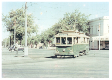 Ballarat Tramway Museum
Photograph - Tram 32 Hospital Corner, Hugh Ballment, late 1950s
Photograph show SEC Ballarat tram 32 turning from Drummond St South into Sturt St. Tram has the destination of Sebastopol which is incorrect. In the background is the grocery shop of H E Herbert. Photo late 1950s.Yields information about tram 32 late 1950s and Hospital Corner.Colour print with photographers stamp on rear.In ink on rear stamp of H R C Ballmenttramcars, city, tram 32, hospital corner, sturt st -
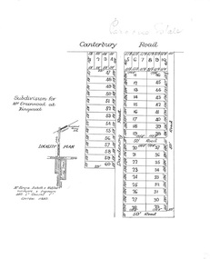 Ringwood and District Historical Society
Plan, Paradise Estate Subdivision, Ringwood, Victoria - circa 1925
Paradise Estate layout also included in Land Sale Brochure Titled Eureka Plan Book - Seven Delightful & Valuable Ringwood Estates - circa 1925, Reg. No. 5100.Subdivision plan of Paradise Estate, Ringwood, showing allotments for sale, with typed page attached showing block sizes and prices.Locality plan showing land for sale south of Canterbury Road, 1 Mile south of Ringwood Railway Station. Subdivison includes Canterbury Road and Dandenong Road (later Wantirna Road). Surveyors - McKenzie Aisbett & Webber, surveyors & engineers, 440 Little Collins Street, Melbourne, Telephone Central 11540. Subdivision for Mr Grenwood at Ringwood. Additional typewritten price list showing footage, price per foot, and price per block for Lots No. 1 to 60. Paradise Estate layout also included in Land Sale Brochure Titled Eureka Plan Book - Seven Delightful & Valuable Ringwood Estates - circa 1925, Reg. No. 5100. -
 Wodonga & District Historical Society Inc
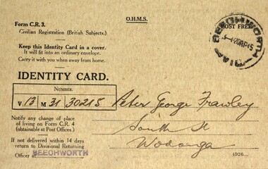
Document - Citizen Identity Cards World War II, Australian Federal Government, 1940s
These cards were issued during World War 11 to British subjects who were civilians. This included all non-indigenous adults born in Australia. The concept of Australian citizenship was only introduced by the Nationality and Citizenship Act of 1948. All adults had personal identity cards and were required to report changes of address to the government. These cards were particularly important in the identification and monitoring of Aliens (non-citizen residents) , particularly non-Europeans and Asian residents.Peter Frawley was a long-time resident of Wodonga. He was a veteran of Gallipoli and Fromelles. For his actions at Fromelles, he was awarded the French Croix de Guerre. After the war Peter became a successful jockey and one of his greatest successes was winning the Australian Steeple Chase at Caulfield in 1922. He was an active member of the Wodonga Turf Club and Bonegilla Race Club and a founding member of the Wodonga Show Society. Peter’s wife Connie was an integral member of the Wodonga Hospital fundraising committee, being awarded a life membership. Nereida Pearl Goyne (nee Emery) lived most of her life in Wodonga. She was actively engaged in the community until 2007 when she moved to Rutherglen where she passed away in January 2009.3 fawn coloured cards with black text, all stamped with the Beechworth Post Office stamp. They are identified as Form C.R.3 Civilian Registration (British Subjects).Written on both sides in ink: Detailed explanation of government regulations. On Card 1 in ink;" V13, M 31 ,30215" Signed "Peter George Frawley, South St Wodonga" Reversed signed by card holder and witness" On Card 2 in ink;" V13, M 02 ,2494" Signed Constance Frawley, South St Wodonga" Reversed signed C Frawley and witnessed P Frawley" Note - Ration book for 3 children" On Card 3 in ink;" V13, M 10 ,12251" Signed "Nereida Pearl Goyne, Bank St Wodonga" Reversed signed by card holder and witnessed by L.C. McCullough" Note Ration book for 2 children"identity cards, civilian registration, world war 2, ww11 -
 Ringwood and District Historical Society
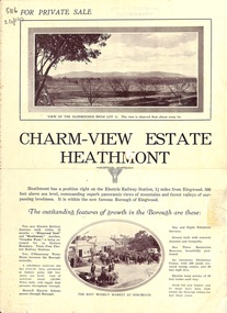
Flyer, Land Sale Brochure, Charm-View Estate, Heathmont, Vic. - c1926
Double sided folded page advertisement highlighting local facilities, services and layout of blocks for sale in Charm-View Estate.Subdivision includes Heathmont Road, Orchid Street, Bennett Avenue, Dickasons Road and Canterbury Road. (Agents) T. Burkitt & Co., Phone Ringwood 157, Overton & Co., 390 Chapel Street South Yarra, Phone Windsor 542. Solicitor A.V. Wischer, 443 Chancery Lane, Melbourne. -
 Glenelg Shire Council Cultural Collection
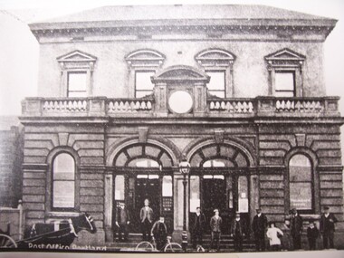
Photograph - Photograph - Post Office, Portland, n.d
Black and white reproductive photograph of earlier image. People standing in front of Post Office building - double storey bluestone with decorative stone balcony.Front: Post Office, Portland (on photograph original). Portland Post Office Cnr Bentinck & Cliff Streets c1900 (built 1991) (typed label, lower centre). Back: B21766/98 (pencil, upper left). State Library of South Australia Photographic Section. Order No. A16493 (stamp, centre).portland post office -
 Ringwood and District Historical Society
Newspaper, Scrapbook Clipping, Library Collection, Ringwood, Victoria, `
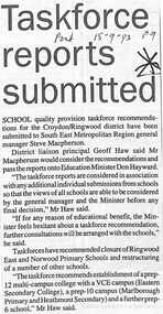
``Newspaper clipping from "The Post", 15-9-93, P9 School quality provision taskforce recommendations for the Croydon/Ringwood district have been submitted to South East Metropolitan General Manager Steve Macpherson. District Liaison proncipal Geoff Haw said Mr Macpherson would consider the recommendations and pass the reports onto Education Minister Don Hayward.` -
![Public Works Street Maintenance, Gellibrand Street [Kew]](/media/collectors/550653872162f11fb04854aa/items/58ce1cc9d0cde409d84fcde4/item-media/58cf6195d0cedc331404a41c/item-fit-380x285.jpg) Kew Historical Society Inc
Kew Historical Society IncPhotograph - Public Works Street Maintenance, Gellibrand Street, 1970
Public Works Street Maintenance, Gellibrand Street, Kew, Company supplied photograph of root clearance from drains. Inscribed above photo: "Cable winch setup with 'snatch block' in manhole. Sample of roots removed on spoil. Gellibrand St. 24.4.70." Company information: "General Descaling / Company / 1st Floor 66-68 Albert Road/ South Melbourne 3205 Victoria / Telephone 699 1455 / 699 1635."general descaling, drains, gellibrand street (kew) -
 Dandenong/Cranbourne RSL Sub Branch
Document - Citation to PM4551 Able Seaman Cyril Percy Whiteman R.A.N.R, Citation to ABLE SEAMAN CYRIL PERCY WHITEMAN, PM445,R .A. N.R, unknown
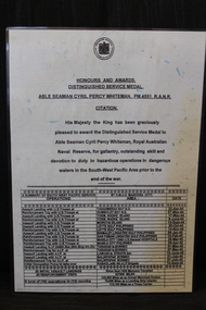
WWII historical significanceCitation His Majesty the King has been Graciously pleased to award the Distinguished Service Medal to Able Seaman Cyril Percy Whiteman. the Royal Australian Naval Reserve, for gallantry, outstanding skill and devotion to duty in hazardous operations in dangerous waters in the South-Wes Pacific Area prior to the end of the war. -
 The Beechworth Burke Museum
Photograph
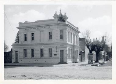
The old Bank of New South Wales building is located on the corner of Camp and Ford streets in Beechworth, Victoria. It was constructed between 1856 and 1857 from local honey coloured granite. It was designed by architects Robertson & Hale and is a two-storey rendered brick building and the original coat of arms is still visible. The coat of arms is distinctive and consists of a kangaroo, emu, lion, and rising sun. The rear of the building was surrounded by high granite walls for security as it was the original home for the local gold office. Beechworth Honey currently offers tourist accommodation in the Hive Apartment located in the former Bank of New South Wales Managers residence.The Bank of New South Wales building in Beechworth is significant for its location in one of Australia's most prominent goldfield towns. Of particular interest is the use of distinctive local Beechworth honey coloured granite in its construction. The building’s architecture is a simple, conservative classical style known as Renaissance Revival. It is one of the few known surviving works of the architects Robertson and Hale. The decorative composition above the main entrance and the counter in the banking chamber are of special interest.Black and white rectangular photograph printed on cardAHold bank of new south wales, bank of new south wales building, beechworth bank of new south wales, bank of nsw, beechworth 1850s, robertson and hale, architects robertson and hale, rendered brick, coat of arms, granite walls, local honey coloured granite, gold office, 1856, 1857, beechworth, beechworth honey, hive apartment, manager's residence, renaissance revival -
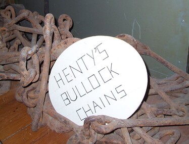 Glenelg Shire Council Cultural Collection
Functional object - Chains - bullock harness, n.d
Thought to be the chains used for the Henty's bullock harness. The Henty family are known as Victoria's earliest European settlers and pastoralists, emigrant squatters who played a defining role in the establishment of Portland and the development of the region's wool trade. Facing challenges as a farmer in early 19th-century England, West Sussex grazier Thomas Henty (1775–1839) turned his sights south to the colonies, where he believed his seven sons would have a brighter future as sheep breeders and wool producers. He had been the first to introduce merino to the south of England, and would do so in the colonies also.Thought to be the chains used for the Henty's bullock harness.Iron chains with fittings for bullock harnesses.farming, rural industry, henty, bullock, chains -
 Eltham District Historical Society Inc
Photograph, 1934 Floods at Eltham
Published in the Diamond Creek Basin Study, 1980 and identified at Diamond Creek, locality not identified, 1934. The location is actually looking south across the Diamond Creek towards Falkiner Street, beside the Main Road bridge at Eltham South from what is now part of Wingrove Park opposite Antoinette Boulevard. The bridge railing is just visible to the left of image. The large leaning Manna Gum beside the bridge still stands in 2021 alongside the Diamond Creek trail. In 1934 extensive flooding of the Yarra River and Diamond Creek set new records for flood plain level (Eltham Chronology, EDHS)Black and white photographCopied by Hugh Fisher, Photographer, 6 York Street Eltham A1678B Floods- Eltham - 1934floods, yarra river, eltham, flooding, diamond creek, flood -
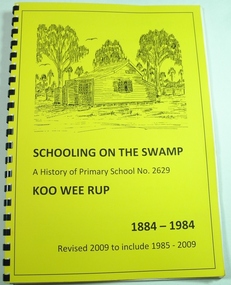 Koo Wee Rup Swamp Historical Society
Book, Koo Wee Rup Primary School, Schooling On The Swamp, November 2009
History of Koo Wee Rup Primary School. Includes information about other schools (past and present) in Koo Wee Rup Swamp area : Bayles, Caldermeade, Cardinia, Catani, Cora Lynn, Dalmore East, Iona, Island Road, Koo Wee Rup North, Koo Wee Rup South, Heath Hill, Lang Lang, Protectors Plains, Modella, Tooradin, Tooradin North, Yannathan, Yannathan South. School Centenary History updated and expanded for 125 anniversary of Koo Wee Rup Primary School (1884-2009) Includes brief account of geography of Koo Wee Rup Swamp, and local indigenous people.A history of Primary School No. 2629, Koo Wee Rup : 1884 - 2009 (Revised for school 125th. anniversary - November 2009) compiled by Don Jewell. 62 pages, A4, plastic spring binding.koo wee rup primary school, centenary history -
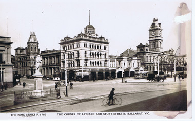 Ballarat Tramway Museum
Photograph - Digital image, Rose Stereograph Co, "Corner of Lydiard and Sturt Streets, Ballarat", c1929
Digital image titled "The Corner of Lydiard and Sturt Streets Ballarat Vic", photo looks south west from the Post Office steps towards the south west corner - has Craigs Hotel, National Mutual Life, town hall shops including Anderson Printer and the Town Hall in the picture along with Robbie Burns statue. The Rose Series Postcard No. P 1783. An ESCo tram is parked at the tram stop - No. 5? A number of horse drawn and motor vehicles are in the photograph. Wal has dated the photo about 1930 on the rear of the postcard and about 1929 in his album notes. See item 9193 for a copy print.Yields information the buildings, buildings and scene at the intersection of Sturt and Lydiard St with a number of vehicles in the view.Digital image from the Wal Jack Ballarat Album of a postcard .trams, tramways, esco, lydiard st, sturt st, town hall, tram 5 ? -
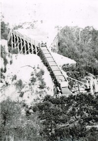 Otway Districts Historical Society
Photograph, Gellibrand Ballast Siding, c.1920
During construction of the railway in 1901 a ballast siding was originally opened 4.5 km south of Barongarook but the ballast proved inferior and a new ballast siding was opened 4 km south of Gellibrand to provide material for track construction. A spur siding, with points facing Beech Forest and a capacity for six trucks, was cut into the side of a slope. Above this was erected a loading bin and chute. This stone was of durable quality so the siding continued in commission after 1902 for periodic track re-ballasting. By the mid-1920s Victoria Railways found it more economic to use ballast from elsewhere so the siding was closed by 1925 and the rails lifted.B/W. Gellibrand Ballast Siding loading ballast down the slope, with five workmen watching at the base.gellibrand; ballast; railways; -
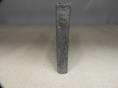 Carlton Football Club
Hardcover Book, Football Record 1914, 194
Hardcover book made in 1914 made to keep original copies of “The Football Record”. This book contains all Football Records relating to Carlton games for the season of 1914. Carlton won their fourth VFL/AFL premiership in 1914 defeating South Melbourne by 6 points at the MCG. Carlton 2.3 5.8 5.8 6.9 45 Sat 26-Sep-1914 2:50 PM Att: 30,495 Venue: M.C.G. South Melbourne 2.5 2.5 3.11 4.15 39 Carlton won by 6 pts Coach – Norman Clark Captain – Billy Dick Leading Goal-kicker – Bill Cook 27 Goals Hardcover book, worn -
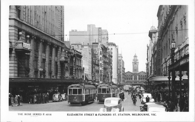 Melbourne Tram Museum
Postcard, Rose Stereograph Co, "Elizabeth Street & Flinders St Station, Melbourne", 1940s
Rose Series postcard No. P 4016 titled "Elizabeth Street & Flinders St Station, Melbourne", showing W5 class trams 742 and 737, both on route 18 in Elizabeth St looking south from Bourke Street. It is a very busy and congested scene with motor and horse-drawn trucks, cars, cyclist and pedestrians. Note the man in a peaked cap in the bottom right-hand corner - a Chauffeur? There is advertisement for "War Saving Certificates" on the balcony of London Stores. Other retailers in Elizabeth Street are Brash's music and Wittner Shoes. The new Royal Bank building is visible on the corner south east corner of Collins Street. Yields information about a busy scene in Elizabeth Street Melbourne in the 1940's .Postcard - printed real photograph with Rose Stereograph Co. name on the rear. Two copies held.Second copy has the K. J Magor stamp on the rear.tramways, trams, elizabeth st, tram 742, tram 737, w5 class, world war ii, route 18 -
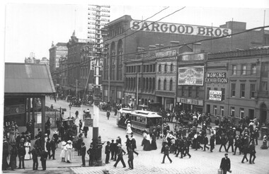 Melbourne Tram Museum
Photograph - Black and white - Flinders St, looking west from Swanston St, c1905
Photograph of Flinders St looking east from Swanston St - shows the entrance to Flinders St station prior to the construction of the current building. In the view are one cable tram, many pedestrians and some horse-drawn vehicles. A hoarding on the left hand side possibly indicates work is underway on the new station building. A sign on the pole advises that cable trams went to Spencer St for a penny and for 3d to Port Melbourne or South Melbourne. In the background are buildings for Sargood Bros, Thomas Whitelaw Home Decorators, The Hub, a sign on the Young & Jackson Hotel advertising a Women's Exhibition. There is a telephone pole line on the south side of Flinders St.Yields information about Flinders St, c1905.Black and white photograph on paper.In pencil on rear "163 OB"trams, tramways, cable trams, flinders st, flinders st station