Showing 999 items
matching government printer
-
 Federation University Historical Collection
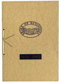
Book, Waller & Chester Printers, Shire of Buninyong 1858-1983, 1983
Documents special meeting of Buninyong Shire Council held on 30 August 1983 to commemorate the 125th anniversary of the first meeting of the Buninyong District Road Board.. Includes images of four generations of Archibald Fisken, photographic copy of Victoria Government Gazette proclamations of the Buninyong Road District, details of inaugural meeting and minutes of the first and second meetings, members of council 1983, a list of Chairmen, Mayors and Presidents and extracts from past records.Beige soft covered book 14 pages with images of four Archibald Fisken, KW McManus and other details related to the 100 years of the Bininyong Shire Council. Ink on paper.Shire of Buninyong 1858-1983buninyong shire council, buninyong road district, archibald fisken, local government -
 Federation University Historical Collection
Booklet, Luplau, Hewood & Riderm Printers, The School of Mines Ballaarat Annual Report 1883, 1883
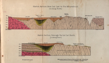
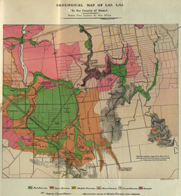
The School of Mines Ballaarat. Annual Report 1883. Statement of Receipts and expenditure, general balance sheet, and list of subscriptions donations 1882. Sketch of School of Mines. Sketch Section from Lal Lal to the Moorabool (looking north) Geological map of Lal Lal. In the County of Grant. Annual Report, Balance Sheet, Certificates granted by the Council, Examination Papers - Elementary Science Classes (Appendix), Extracts from Visitors' Book, Fees, Form of Bequest, Honorary Correspondents. Life Governors, Museum - open to visitors, Notes on the Geology of Lal Lal (with Geological Plan & Sections), Obituary, Office Bearers, Paper of Particulars, Rules of the Ballaarat Field Club and Science Society (Appendix), Report of the Curator of the Museum and Library, Report of the Superintendent of Laboratories, Report of the Lecturer in Mathematics, Report of the Lecturer in Mechanical Engineering, Report of the Lecturer in Telegraphy, Report of the Lecturer in Materia Medica, Statement of Receipts and Expenditure for the year 1882, Subjects and Lectures, Subjects and Examiners, Subscriptions and Donations, from 1st January to 31st December 1882.Ballaarat School of Mines annual Report. Hard cover red book of 101 pages. Includes plans on Lal Lal and surrounds. ballarat school of mines, annual report, balance sheet, certificates granted by the council, examination papers, extracts from the visitors' book, fees, form of bequest, honorary correspondents, life governors, museum, notes on the geology of lal lal, obituary: charles william thomas. one of the examiners in mining and surveying, office bearers, paper of particulars, rules of the ballaarat field club and science society, report of the curator of the museum and library, report of the superintendent of laboratories, report of the lecturer in mathematics, report of the lecturer in mechanical engineering, report of the lecturer in telegraphy, report of the lecturer in materia medica, statement of receipts and expenditure for the year 1882, subjects and lectures, subjects and examiners, subcriptions and donations, from 1st january to 31st december 1882, alf. mica smith, professor of chemistry, alf. mica smith, metallurgy, f. m. krause - professor of geology, mineralogy, scientific mining, t. h. thompson, practical mining, w. h. shaw mechanical engineering, h. reid, mechanical enginnering, phoenix foundry company (limited), a. a. buley, mathematics, f. m. krause, land, mining and engineering surveying, w. d. campbell, telegraphy, james oddie, vice-president, alf. mica smith, natural philosophy (elementary mechanics and hydrostatics, magnetism and electricty, sound, light and heat), j. f. usher, materia medica, pharmacy and physiology, examiner, professor h. m. andrew, m. a., examiner, h. d. de la poer wall, m. a, c. e., examiner, thomas mann, b. a., examiner, p. c. fitzpatrick, c. s., examiner, h. rosale, j.p., f.g.s, m.e. and m, examiner, john lewis, examiner, w. c. kernot, m.a., c.e., examiner, professor mccoy, examiner, j. cosmo newbery, c.m.g., b. sc., examiner, baron von mueller, k.c.m.g., m. et ph. d., f. r.s., examiner, sam. w. macgowan, examiner, w. p. bechervaise, examiner, r. l. j. ellery, f.r.s. govt. astronomer, examiner, f. m. krause, c.e., examiner, j. m. bickett, examiner, n. kent, examiner, a. martin, examiner, r. s. mitchell, examiner, w. h. keast, examiner, p. matthews, examiner, d. milliken, examiner, j. t. richards, examiner, jonathan robinson, examiner, t. h. thompson, examiner, h. brookes allen, m.d., examiner, joseph bosisto, examiner, c. r. blackett, m.l.a., examiner, wm. johnson, analyst to the government of victoria, ferdinand krause, ballarat field naturalists club, ferdinand von mueller, thomas mann, a.a. buley, ferrdinand krause, alfred mica smith, james oddie, william johnson, jonathan robinson, james bickett, r.l.j. ellery, cosmo newbery, ballarat field naturalists -
 Federation University Historical Collection
Booklet, The School of Mines Ballaarat Annual Report 1883, 1883
The School of Mines Ballaarat. Annual Report 1883. Statement of Receipts and expenditure, general balance sheet, and list of subscriptions donations 1883. Annual Report, Balance Sheet, Certificates granted by the Council, Examination Papers - Elementary Science Classes (Appendix), Fees, Honorary Correspondents. Life Governors, Museum - open to visitors, Office Bearers, Paper of Particulars, Report of the Curator of the Museum and Library, Report of the Superintendent of Laboratories, Report of the Lecturer in Mathematics, Report of the Lecturer in Mechanical Engineering, Report of the Lecturer in Telegraphy, Report of the Lecturer in Materia Medica, Report of the Lecturer of Astronomy, Scale of Charges for Assays and Analyses, Examinations Held, Statement of Receipts and Expenditure for the year 1883, Subjects and Lectures, Subjects and Examiners, Subscriptions and Donations, from 1st January to 31st December 1883.Ballaarat School of Mines annual Report. Soft cover pale green booklet of 67 pages. Includes a colour Geological Map of Lal Lal and a sketch Section from Lal Lal to the Moorabool. Inscription on front cover 'Office Copy' On pages 4 and 5 some names have been crossed out and others added.ballarat school of mines, annual report, balance sheet, certificates granted by the council, examination papers, fees, honorary correspondents, life governors, museum, office bearers, paper of particulars, ballarat school of mines museum, library, superintendent of laboratories, mathematics, mechanical engineering, telegraphy, lecturer in materia medica, statement of receipts and expenditure for the year 1882, examiners, subcriptions and donations, alfred mica smith, chemistry, metallurgy, f.m. krause, ferdinand krause, geology, mineralogy, scientific mining, t.h. thompson, practical mining, w.h. shaw, h. reid, mechanical enginnering, phoenix foundry company (limited), phoenix foundry, arthur. a. buley, mining, engineering surveying, walter. d. campbell, j. wall, astronomy, james oddie, natural philosophy, elementary mechanics and hydrostatics, magnetism and electricty, sound, light and heat, j.f. usher, materia medica, pharmacy, physiology, w.h. shawmechanical engineering, h.m. andrew, h.d. de la poer wall, thomas mann, p.c. fitzpatrick, h. rosale, john lewis, w.c. kernot, mccoy, j. cosmo newbery, baron von mueller, samuel w. macgowan, w.p. bechervaise, r.l.j. ellery, astronomer, j.m. bickett, james bickett, n. kent, a. martin, r.s. mitchell, w.h. keast, p. matthews, d. milliken, j.t. richards, jonathan robinson, h. brookes allen, joseph bosisto, c.r. blackett, m.l.a., william. johnson, government of victoria analyst, moorabool, lal lal, skipton, coal, skipton coal discovery, lal lal creek, moorabool falls, lal lal race course, lal lal falls, moorabool river, william h. keast -
 City of Moorabbin Historical Society (Operating the Box Cottage Museum)
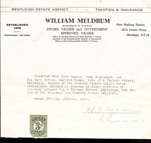
Document - Document, deposit receipt 1950, c1950
Mr John Herron and his wife Isa Mary Herron purchased the house at 4 Vickery Street Bentleigh in 1950 from Miss M Marriott. He was a descendant of John James an early settler dairyman in Moorabbin Shire and Miss M Marriott was a descendant of the early settler market gardeners Marriott family. Mr Herron lived there until 1989 and the house was then demolished and turned into a carpark for the busy Shopping precinct of Centre Road, Bentleigh.The Marriott family were early settler market gardeners from 1878 in the area of Dendy’s 1841 Special Survey and John Herron was a descendant of Philip Jones , a chair-maker, who settled in the area of East Brighton, now Bentleigh, in 1852An original paper statement of receipt issued by William Meldrum for £100 deposit paid on March 28th 1950 by Mr John Herron for purchase of the house at 4 Vickery Street BentleighBENTLEIGH ESTATE AGENCY TAXATION & INSURANCE / WILLIAM MELDRUM / ESTABLISHED / 1908 Incorporating W.H.Wood & Co., Next Railway Station,/ SWORN VALUER and GOVERNMENT / APPROVED VALUER 367 a Centre Road / Bentleigh / Telephone XU 1404 / Fellow of the Real Estate and Stock Institute of Victoria / Associate of the Commonwealth Institute of Accountants/ Fellow of the Commonwealth Institute of Valuers Stamp in left bottom VICTORIA STAMP DUTY 3d with signature initials / Letter dated 28th day of March 1950 and signed SP W Meldrum / C Raveand pioneers, early settlers, brighton, moorabbin, bentleigh, market gardeners, dairyman, dairy farmer, jones james, jones mary ann, jones martha, jones elizabeth ann, dendy henry, dendys special survey 1841, elster creek, melbourne, jones ethel may, herron isa mary, herron john, tram conductor, marriott m, solicitors, valuers, taxation, meldrum w, real estate -
 City of Moorabbin Historical Society (Operating the Box Cottage Museum)
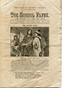
Magazine - The School Paper, Albert J Mullet, For Grades VII and VIII (1916), c1916
... of Victoria, printed Albert J Mullett, Government Printer, Melbourne ...Issue no 206 of The School Paper December 1916. This School Paper was owned by, Roy Marriott, a child of one of the pioneer families of City of Moorabbin.Issued by the Education Department of Victoria, printed Albert J Mullett, Government Printer, MelbourneA 16 page magazineEDUCATION DEPARTMENT VICTORIA / SCHOOL PAPER / For Grades VII and VIII (1916); Issue no 206 Ed. Dept of Victoria education, victoria, australian history, victorian education department, marriott, moorabbin, bentleigh, school -
 City of Moorabbin Historical Society (Operating the Box Cottage Museum)
Magazine - The School Paper for Grades V and VI (1918) No 233 - 229 Jan 1918- Nov 1918, Albert J Mullett for Department of Education Victoria Australia……………………………………………………, The School Paper for Grades V and VI (1918), c1918
... Albert J Mullett, Government Printer, Melbourne 1918 education ...Issue no 233 - 229 of The School Paper Jan - Nov 1918, 11 Editions. This binder with copies of The School Paper was owned by Roy and Wilfred Marriott, children of one of the pioneer families of City of Moorabbin.Issued by the Education Department of Victoria, printed Albert J Mullett, Government Printer, Melbourne 1918 Issue No 223-229 of The School Paper January – November 1918 This School Paper was owned by one of the pioneer families of City of Moorabbin, EDUCATION DEPARTMENT VICTORIA / SCHOOL PAPER / For Grades V and VI (1918); Issue no 233-229 Ed. Dept of Victoria / Poetry Number Signed W Marriott education, victoria, australian history, victorian education department, marriott, moorabbin, bentleigh -
 City of Moorabbin Historical Society (Operating the Box Cottage Museum)
Magazine - The School Paper for grads VII and VIII (1920), c 1920
... Mullett, Government Printer, Melbourne education victoria ...Issue no 242 - 253 of The School Paper Jan - Dec 1920, 12 Editions. This binder with copies of The School Paper was owned by W Marriott child of one of the pioneer families of City of Moorabbin,Issued by the Education Department of Victoria, printed Albert J Mullett, Government Printer, MelbourneThe School Paper For Grades VII and VIII (1920)EDUCATION DEPARTMENT VICTORIA / SCHOOL PAPER / For Grades V11 and VI11 (1920); Issue no 242 Ed. Dept of Victoria / Poetry Number education, victoria, australian history, victorian education department, marriott william, marriott geoff, market gardeners, pioneers, moorabbin shire, henry dendy special survey brighto 1841, east bentleigh state school no. 2083, wilfred marriott -
 City of Moorabbin Historical Society (Operating the Box Cottage Museum)
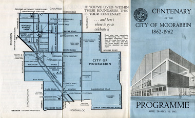
Pamphlet - Centenary of the City of Moorabbin 1862 - 1962, Programme April28 - May16, 1962, 1962
In 1962 the City of Moorabbin celebrated one hundred years of self local-government. The celebrations commemorated those who helped form the City of Moorabbin and to recognise their achievements. In May 1862 the Moorabbin district, which included Sandringham, Mentone and Mordialloc was made a Road Board District, on 27 January 1871 it was made a shire and then on 29 November 1934 Moorabbin was proclaimed a City. On 15 December 1994, the City of Moorabbin was abolished, and was split three ways; Bentleigh was transferred into the newly created City of Glen Eira along with the City of Caulfield; Cheltenham was transferred to the newly created City of Bayside, along with the Cities of Brighton and Sandringham; while the bulk of the city merged with the Cities of Mordialloc, Chelsea and parts of Springvale, to become the newly created City of Kingston.A souvenir of the celebration of 100 years of self government by theearly settlers from Moorabbin Roads Board 1862 until City of Moorabbin 1934-62 A tri-fold pamphlet colour print on outside and black and white inside. List of Councillors of City of Moorabbin 1961-1962 - Programme of all the events held to celebrate the Centenary of the City of Moorabbin from April 28 - May 16, 1962Centenary /of the / City of Moorabbin / 1862 -1962city of moorabbin, centenary, celebrations, floats, parade -
 City of Moorabbin Historical Society (Operating the Box Cottage Museum)
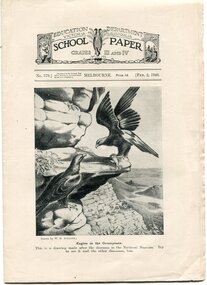
Magazine - The School Paper for Grades III and IV (1948) No 569 to 597; Feb 1948 to Dec 1948, 11 Editions, 1948
... Department of Victoria, printed J. J. Gourley, Government Printer ...School Papers were issued to the children going to school in the state of Victoria by the Education Department for a cost of 1 penny per issue. These copies were collected and saved by one of the pioneer families of City of Moorabbin.Issued by the Education Department of Victoria, printed J. J. Gourley, Government Printer, Melbourne The School Paper For Grades III and IV (1948)EDUCATION DEPARTMENT VICTORIA / SCHOOL PAPER / For Grades III and IV (1948)education, victoria, australian history, victorian education department, marriott william, marriott geoff, market gardeners, pioneers, moorabbin shire, henry dendy special survey brighto 1841, east bentleigh state school no. 2083 -
 City of Moorabbin Historical Society (Operating the Box Cottage Museum)
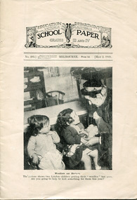
Magazine - The School Paper for Grades III and IV (1949) No 293 May and No 597 September, 2 editions, 1949
... Department of Victoria, printed J. J. Gourley, Government Printer ...These School Papers were issued to the children going to school in the state of Victoria by the Education Department for a cost of 1 penny per issue. This copy was collected and saved by one of the pioneer families of City of Moorabbin.Issued by the Education Department of Victoria, printed J. J. Gourley, Government Printer, MelbourneThe School Paper For Grades III and IV (1949) 12 pagesEDUCATION DEPARTMENT VICTORIA / SCHOOL PAPER / For Grades III and IV (1949)education, victoria, australian history, victorian education department, marriott william, marriott geoff, market gardeners, pioneers, moorabbin shire, henry dendy special survey brighto 1841, east bentleigh state school no. 2083 -
 City of Moorabbin Historical Society (Operating the Box Cottage Museum)
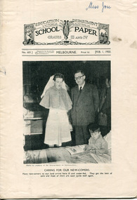
Magazine - The School Paper for Grades III and IV (1950), 1949
... Department of Victoria, printed J. J. Gourley, Government Printer ...These School Papers were issued to the children going to school in the state of Victoria by the Education Department for a cost of 1 penny per issue. This copy was collected and saved by one of the pioneer families of City of Moorabbin.Issued by the Education Department of Victoria, printed J. J. Gourley, Government Printer, MelbourneThe School Paper For Grades III and IV (1950) 12 pagesEDUCATION DEPARTMENT VICTORIA / SCHOOL PAPER / For Grades III and IV (1950)education, victoria, australian history, victorian education department, marriott william, marriott geoff, market gardeners, pioneers, moorabbin shire, henry dendy special survey brighto 1841, east bentleigh state school no. 2083 -
 City of Moorabbin Historical Society (Operating the Box Cottage Museum)
Magazine - The School Paper, Grades 5 and 6, No. 795 December 1968 and Grades 3 and 4, No. 809 December 1968, The last issue of The School Paper, 1968
... of Victoria, printed J. J. Gourley, Government Printer, Melbourne ...These School Papers were issued to the children going to school in the state of Victoria by the Education Department for a cost of 1 cent per issue. These were the last edition of the School Paper to be printed. This copy was collected and saved by one of the pioneer families of City of Moorabbin.Issued by the Education Department of Victoria, printed J. J. Gourley, Government Printer, MelbourneThe School Paper For Grades 5 and 6 (1968) and For Grades 3 and 4 (1968)EDUCATION DEPARTMENT VICTORIA / SCHOOL PAPER / For Grades III and IV (1950)education, victoria, australian history, victorian education department, marriott william, marriott geoff, market gardeners, pioneers, moorabbin shire, henry dendy special survey brighto 1841, east bentleigh state school no. 2083 -
 Bendigo Historical Society Inc.
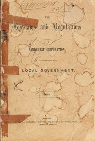
Book - BENDIGO SALEYARDS COLLECTION: THE BYE-LAWS AND REGULATIONS OF THE SANDHURST CORPORATION
Book with faded and stained pink cover. Much of the book held together with sticky tape. Titled The Bye-laws and Regulations of the Sandhurst Corporatiion, in connection with Local Government 1889. Printed by J. B. Young, General Printer, Book-Binder, Lithographer, &c., Lyttleton Terrace. Contained in the book are Regulations on buildings, parks, carriages, animals, noxious trades shops and tents.bendigo, council, cattle markets, bendigo saleyards collection - the bye-laws and regulations of the sandhurst corporation 1889, j b young, henry hattam, dugald macdougall, ebenezer neill, john buckley, j a woodward, w d c denovan, w g jackson, john delbridge, s h mcgowan, jacob cohn, j w colville, alexander bayne, d c sterry, john a woodward, patrick hayes, t jefferson conmnelly -
 Bendigo Historical Society Inc.
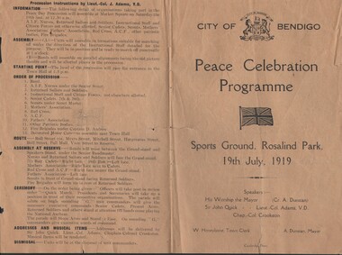
Document - PROGRAMME - PEACE CELEBRATION 1919, 1919
Programme - Peace Celebration 1919 - City of Bendigo. Held at Sports Ground, Rosalind Park, 19th July 1919. Programme (including Address by Sir John Quick), presided over by Cr A Dunstan, Mayor. Procession instructions on back page ( 4 pages - one fold) Printer: Cambridge Press.organization, government, city of bendigo -
 Bendigo Historical Society Inc.
Document - OFFICIAL INVITATION MAYOR OF BENDIGO. 7.10.1902, 7.10.1902
Card - Official Invitation by the Mayor of Bendigo and Mrs J.H. Curnow. Town Hall, Bendigo. 'At Home' 7.10.1902. Musical Programme. Songs sung/played by Mr J.Gray. Miss Ruby Lamb. Mr W.Cahill. Miss F.Bolton. Miss A & Mrs J.F.Warren. Miss Kilfedder. Mrs Higgins. Mrs J.Morgan. Mr J.F.Warren. Written on back Mayor 1902-03 and 1903-04. Card made with cardboard lace on edges, raised flower on front. City of Bendigo stamp on back. Photo of The Mayor and Mrs Curnow.T.Cambridge, Art Printer & Engr.organization, government, city of bendigo, card. official invitation bendigo mayor and mrs curnow. 7.10.1902. musical programe. -
 Bendigo Historical Society Inc.
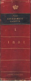
Book - MCCOLL, RANKIN AND STANISTREET COLLECTION: VICTORIAN GOVERNMENT GAZETTE, 1881
Book; 'Victorian Government Gazette', Volume LXI, 1st January to 30th June 1881. Rob't S. Brain, Acting Gov't Printer, Melbourne. 1872 pages.government, state, vic gov't gazette, mccoll rankin & stanistreet -
 Bendigo Historical Society Inc.
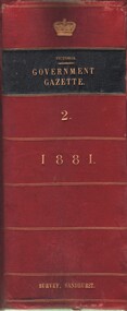
Book - MCCOLL, RANKIN AND STANISTREET COLLECTION: VICTORIAN GOVERNMENT GAZETTE, 1881
Book; 'Victorian Government Gazette'. Volume LXII. 1st July to 31st December 1881. John Ferres, Gov't Printer Melbourne. Pgs 1873 to 3663, plus index 33pages.MCCOLL RANKIN & STANISTREETgovernment, state, victorian government gazette vol ii, mccoll rankin & stanistreet -
 Bendigo Historical Society Inc.
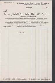
Document - CAMBRIDGE PRESS COLLECTION: ACCOUNT - ANDREW'S AUCTION ROOMS
Account page from Andrew's Auction Rooms, Queen Street and Lyttleton Terrace, Bendigo. James Andrew & Co. D. Andrew, Auctioneer. Government Auctioneers, Sworn Valuators, Produce and Commission Agents. Agents for the City Mutual Fire Insurance Coy. Date line ends 192-. Printed in black with blue cash lines.business, printers, cambridge press, cambridge press collection, andrew's auction rooms, james andrew & co., d andrew, city mutual fire insurance coy -
Port Melbourne Historical & Preservation Society
Book - Municipality of Sandridge, cash book, Mason and Firth, Printers, 1860
Cash Book - Municipality of Sandridge 1860-63. Cash and Contra headings. Pasted note to front inside cover. From Thomas Swallow. Marbled brown coverlocal government - municipal district of sandridge, thomas swallow -
Port Melbourne Historical & Preservation Society
Book, Arnell & Jackson, Printers, Manufacturing, Stationers, Town of Port Melbourne. Index to Government Gazettes, 1907
Town of Port Melbourne. Index to Government Gazettes. Copies of government gazettes from 1870s onwards. red leather cover and spinelocal government - borough of sandridge, local government - borough of port melbourne -
 Port Melbourne Historical & Preservation Society
Book - Victorian Municipal Directory, 1892
Donor's father, Mr W S Lang, was city valuer of City of Port MelbourneFaded green paper cover with 1898 and W S Lang stamped on front, Victorian Municipal Directory with gazeteer and waterworks. Irrigation Trusts record for 1898Title Page; "W S Lang, 11 Ashby Grove, Ivanhoe, Tel 499219built environment, local government - town of port melbourne, w s lang -
Port Melbourne Historical & Preservation Society
Book - Town of Port Melbourne, Contracts, 1900
Town of Port Melbourne contracts number 804 to 943 between 10.11.1903 and 20.09.1914. On inside cover details of printers and "No 89571 10.11.03"Contract Register, Town of Port Melbourne (on spine)local government - town of port melbourne -
Port Melbourne Historical & Preservation Society
Administrative Record - Agenda, Sandridge Borough Council, 18 Jan 1879
Business Agenda for Sandridge Borough Council meeting 1879local government - borough of sandridge, edward clark, town clerks -
Port Melbourne Historical & Preservation Society
Book - Town of Port Melbourne, Rates cash book, Arnell & Jackson, Printers, Manufacturing, Stationers, 1910 - 1914
Town of Port Melbourne. Rates cash Book. June 9th 1910 to June 4th 1914local government - town of port melbourne -
Port Melbourne Historical & Preservation Society
Book - Town of Port Melbourne, financial reports, Arnell & Jackson, Printers, Manufacturing, Stationers, 1909 - 1919
A.09.03.DB Council of the Town of Port Melbourne - financial reports for the period 1908/09 to 1920local government - town of port melbourne -
Port Melbourne Historical & Preservation Society
Book - Borough of Sandridge, rate book, Mason and Firth, Printers, 1860 - 1864
Borough of Sandridge Rate Book - arrears of rates fee for the years 1860 to 1864local government - borough of sandridge -
Port Melbourne Historical & Preservation Society
Book - Town of Port Melbourne, Contract ledger, Arnell & Jackson, Printers, Manufacturing, Stationers, 1893 - 1902
Town of Port Melbourne - Contract ledger 1893 to 1902local government - town of port melbourne -
Port Melbourne Historical & Preservation Society
Book - Town of Port Melbourne, Loans Ledger, Arnell & Jackson, Printers, Manufacturing, Stationers, 1881 - 1893
Town of Port Melbourne, Loans ledger covering loan liability for 1881, 1887, 1893. Lagoon Act liability. Total Loan liabilities. Loans 1881,1887, 1893. Expenditure and bank account. 1881-1915local government - town of port melbourne, local government - borough of sandridge, local government - borough of port melbourne -
Port Melbourne Historical & Preservation Society
Functional object - Printing block, City of Port Melbourne, 1930s - 1940s
Steel printer's block of City of Port Melbourne insignia vintage 1930s? Image is reversed in solid 4cm squarebusiness and traders, local government - city of port melbourne, printing -
Port Melbourne Historical & Preservation Society
Book - Port Melbourne Council, Arnell & Jackson, Printers, Manufacturing, Stationers, Dog Register, 1890 - 1901
Port Melbourne Council Dog registrations 1892 to 1901, with alphabetised index by surname of owner; with registration fee, breed, sex and age of dog recordedlocal government - town of port melbourne, domestic life, dogs