Showing 1194 items matching " howard"
-
 Ballarat Heritage Services
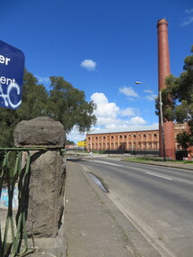
Photograph - Photograph - Colour, Sunnyside Mill Bridge over the Yarrowee, Hill Street, Ballarat, 2016, 17/09/2016
"A joint meeting of city and town ratepayers, convened by Messrs Francis Jago and Henry Johns, interested in the formation of a cart bridge in Hill street, over the Yarrowee Creek, was held on Saturday evening, in the Societies Hall, corner of Skipton and South streets, with the view of taking united action in the matter. Mr Morris was voted to the chair, : and about 60 persons were present. The chairman stated that the object of the meeting was that united influence should be brought to bear upon the City and Town Councils, so that a cartbridge should be erected. He said that Mount Pleasant would no doubt be thickly populated in a few years, and the bridge would prove a great boon to the inhabitants of the locality. By means of a cart bridge drays, would be enabled to save on their journeys to and fro between the mount and the batteries, at least a mile and a half each time. He hoped that the councillors for the south ward would assist them in this matter. Mr Jago, as one of the conveners of the meeting, said that united action on the part of both eastern and western ratepayers was requisite, so as to exert a strong pressure upon the City and Town Councils, in order that the work should be carried but. Mr Grainger moved the first resolution as follows;—“ That the construction of a cart bridge over the Yarrowee Creek at Sunnyside, to facilitate communication between the residents of the city and town, is urgently necessary, and that in the interests of both municipalities the two councils be asked to at once jointly carry out the work. In doing so he said that the necessity of a cart-bridge for the residents of Mount Pleasant would be apparent when the number of batteries, tanneries, and also the Woollen Mill, in the district were considered. The place was of growing import ance, and ready communication should at once be established. Another reason was that an immense saving in time would be effected. It was quite a common occurrence to see one, two, or three drays stuck in the bed of the creek which had gone that way to make a short cut. Now, what with the horses floundering about and breaking their harness, it seemed a wonder to him that life had not been destroyed before now, just through the want of a cartbridge. Mr Johns seconded the resolution. Mr Robert Calvert supported the resolution, and said that it was disgraceful action on the part of the representatives of the south ward that the work had not been executed long ago. They should come together like men and demand that the work should be done, and if not done they should not pay rates until it was. (A voice—“But they’ll make us.” Laughter.) The wooden footbridge across the creek was “only a wooden fabric, not fit for a Christian to walk across, and steps should be taken to remedy this also. Mr Blight, a resident of Mount Pleasant, said that, in common with others, he had been opposed to the erection of the bridge two years ago, but his views had since been altered. Cr. Morrison, who was present, said that the fault of the cartbridge not being erected over the Yarrowee at Hill street lay not with the City Council, but with their neighbors, who had always been opposed to its erection there. In 1874 a motion was carried at a meeting of ‘the City Council" by which the sum of £5OO had been voted to carry but the work. As the bridges over the Yarrowee were joint undertakings of the city and town, they had, by the provisions of an act of Parliament, called upon the Town Council to assist them in the erection of the bridge. In consequence, a conference of the two corporate bodies had taken place, when a motion was moved by Cr Howard, the representative of the south ward, and seconded by Cr Turpie, of Ballarat East—“ That the bridge should be erected at Hill street.” The motion was rejected, principally through the eastern representatives, who wanted the bridge lower down. Since then the two councils had often met to consider, the question of bridges over the Yarrowee Creek, but nothing had been done at the meetings, as the Eastern Council wanted the bridge in one place and the City Council in another. He had himself, when first elected to the council, given notice of motion affirming the desirability of a bridge, at the place now fixed upon. The Woollen Company was growing in importance, and a direct, road to its works would greatly advance its interests. For the working, expenses of each ward £400 was annually, appropriated; and this amount would not be sufficient carry out the work. They would have to obtain a special grant of about £900, as Hill street would require a culvert to be erected therein, as now it was virtually an open drain which carried the drainage of the western plateau to the Yarrowee. He advised that strong pressure should be exerted, specially upon the Eastern Council, and then the work might be carried out. He thought that if the foot bridge was repaired, and large stones thrown into the creek, it would do until the bridge could be erected. The chairman then put the resolution, and it was unanimously carried. Mr Hamilton moved the second resolution— “That Messrs Fern, Greenwood, Peirce, and Jago be deputed by the meeting to wait upon the City and Town Councils and present the first resolution; also that petitions in its favor be signed by all ratepayers interested.” Mr Haigh seconded the resolution, which was carried. Votes of thanks to Cr Morrison for his attendance, and to the chairman for presiding, were passed, and the proceedings terminated." (Ballarat Star, 9 August 1881, page 3) "WOOLLEN MILL BRIDGE YARROWEE IMPROVEMENTS Though brief the official ceremony of opening the bridge across the Yarrowee Creek, near the Sunnyside Woollen Mills, was of an interesting character. It took place at noon yesterday in the presence of the Mayors and councillors of the City and Town. Hon. F. Hagel thorn (Minister of Agriculture).Hon Brawn. M.L.C., Lt-Col Morton (Acting City Clerk). Mr J. Gent (Town Clerk of Ballarat East), Mr A. Farrer (City Engineer), Lt. L. Finch (who is about to leave for the Front, and who assisted Messrs A. Farrer and G. Maughan in carrying out the project, Mr W. Hurdsfield (Clerk of Works) and others. An apology was received from Mr J. McClelland, contractor for the work. Mayor Hill expressed pleasure in Introducing Mr Hagelthorn, who had at great personal sacrifice and inconvenience come from Melbourne to perform the opening ceremony of that beautiful bridge, which was of great improvements that had been effected.When Mr Hagelthorn was Minister of Pubic works he visited Ballarat specially to see the condition of the creek, which at that time was in a disgusting state from a sanitary standpoint. After viewing the position, and realising the justice of the claim. Mr Hagelthorn made strong representations to the Government of which the was a member with the result that it voted £17,000 for the work. That action had been the means of turning a plague spot into a thing of beauty. They therefore owed a deep debt of gratitude to Mr Hagelthorn and the Government of which he was a member, and they were particular grateful to Mr Hagelthorn for coming to Ballarat to perform the open ceremony. Mayor Levy said he could bear testimony to the good work Mr Hagelthorn had always done for Ballarat. In him Ballarat and district always had a good friend. He thought Mr Hagelthorn would feel amply gratified at seeing the good work that had been done. It would serve as some reward for the expenditure, on behalf of the residents of Bal larat, of the amount of money made available through Mr Hagelthorn's instrumentality for the two municipalities. Otherwise the City and Town councils would not have been able to carry out so necessary and so beneficial a work. There was a great amount of work yet to be done, and when the financial market became low stringent Mr Hagelthorn would no doubt be pleased to take the necessary steps to have money provided for further works which could not be undertaken at the present time. The adjacent woollen mill was a standing monument to what was being done in Ballarat, and what ever the City and Town Councils or the Government could do to encourage such manufacturing enterprise should be done, and he was glad to be able to say that was being done as far as finances would permit. He concluded by presenting Mr Hagelthorn with a gold mounted pocket-knife with which to cut the ribbon stretched across the centre of the structure as a bar to traffic. The Hon. F. Hagelthorn, who was greeted with applause said before him was a good work well done in the interests of the public. Real prosperity could only be achieved by a movement carried out by the people to increase natural productiveness. Most of them had been made aware, on account of the war par tiularly, that the people who were best equipped, the industries that were best organised, and the Governments that were most intelligently controlled would get the most of this world's goods and some of its luxuries that Would be denied other people less efficient. Any thing the Government could do to promote industry and to increase the reward of those engaged in it, both employer and employee, would be done. Most Governments would do but little in that regard. ... " (Ballarat Courier, 13 September 1916, page 4)Bluestone and iron bridge over the Yarrowee River at Hill Street, Ballarat.sunnyside mill, sunnyside woollen mill, ballarat woollen mill, bridge, yarrowee creek, francis jago, mount pleasant, yarrowee river, robert calvert -
 Federation University Historical Collection
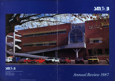
Booklet - Annual Review, Ballarat School of Mines Annual Review, 1986 -1991
The Ballarat School of Mines was established in 1870 through the initiatives of the Ballarat Mining Board making it the oldest site of technical education in Australia. The Board was concerned with the shortage of mine managers for the goldfields. Classes began in surveying, mathematics, and chemistry and a decade later they included metallurgy , assaying and geology. With the decline in goldmining the direction of the college changed and broadened, the art School was established and the Ballarat Junior Technical School developed. In 1976, the tertiary sector seperated from the School of Mines and Industries Ballarat to form the Ballarat College of Advanced Education. In the 1980s SMB was a Community College of Technical Education and Further Education (TAFE) offering a wide range of vocational, enrichment and preparatory programs. It is continuing the tradition of providing for the educaiton needs of people within the Central Highlands. During the 1970s and 80s it acquired and refurbished old buildings and developed new facilities to keep up with the needs of an expanding curriculum and student population. The era of these annual reports is just before the merger with the University of Ballarat.A number of soft card covered annual report for the Ballarat School of Mines. .1) 12 page black covered report featuring an image of the E.J. Tippett Library. Includes information on death of E.J. Tippett, disability policy, Peter Quinn, Patti McNulty, Bob Feary, Shane Everand, Integration, Fiona Watson, retirement of Robert Morgan, Opening of the carpentry and Joinery Facility in Davey Street, formation of the School of Business and Information Technology, Melissa Bone, opening of the E.J. T. Tippett Learning Resource Centre (Library), Refurbishment of the Administration Building, Food Service Building (Prospects), Court House Theatre, Enrolment centre, Museum, Creche, Women's Trade technical Program, Rural Education Program, Ararat Prison Program, Community Studies Section, Ararat Adult Literacy Group. Literacy Assistance for Undergraduates, Fire training, fitness, open Learning, Training & Employment Group, Awards, Filipino Visitors, oil Seed Research, Brunei, Barometer (gift) for Horticulture, Special Equipment (guillotine and brake press; programmable logic Controller; theodolite: laser lever; Universal testing Machine; Atomic Absorption Spectrophotometer)., organisational Structure. Photos include Ken Flecknoe, Peter Quinn, Patti McNulty, Bob Feary, Shane Everard, Fiona Watson,Linda Bland, Robert Morgan, David McCaughey, E.J. Tippett, Frank Sheehan, Julie Baulch, Jo Reeves, Col McCurry, Jenny Garnham .3) Blue covered book with a photograph of the M.B. John Building taken from Albert Street on the cover. Topics include: Ken Flecknoe, Peter Shiells, Ararat Campus, David Haddow, Kevin Martin, Rendle Hannah, Gary Eason, Geoff Pope, Albert Peart, M.B. John building opened, Hairdressing Salon, Community Centre, Creche, closure of Lydiard Street, Museum, Jenny Levison, Inskill, Small Business Training, Ballarat Eat free Library, Barkly Street, Wormalds Valve Group, Aboriginal Programs, Horticulture Center, Awards, Country fire Authority, tractor Donation, Women's Policy. Special purchases included surveying equipment with data recorder, test rig , CDT MIG welder, compact gas chromatograph with FID and single pen recorder, Olivetti stand-alone word processing unit. Images include Ken Flecknoe. Peter Shiells, John Crowe, Trevor Slater, Brian McLennan, Kerrie Cross, Albert Peart, John Cain, M.B. John, Enrollment Centre, Museum, Jo Watson, Wormalds, Brian Webber, Dianna Nikelson, Ian Aitken, Brendan B, Chez Dichiera, Heather Dixon, Julie Broadbent .4) 1993 - Brown and white soft covered annual review featuring students of the Ballarat School of Mines at work. Bill Gribble, Brian McLennan, Peter Shiells Retirement, Robert C. Lovett, Steven Mendelson, Max Palmer, Jenny Gough, Mary Molloy, Barrie Firth, Colin McCurry, Dora Hormann, Organisation Structure, Brewery Acquisition, Humffray Street Primary School, Grant Street Retaining Wall, Neville Bunning Plaque, VCE Plus, Ballarat Small Business centre, Ararat Prison, Ballarat Showgrounds Rotunda, .6) Green covered annual review with an aerial photograph over Albert Street, Ballarat. Content include Kerrie Cross, Peter Shiells. Kenneth Flecknoe Obituary, Ian Pimblett, Keith Boast, David Nicholson, Max Palmer, Brian Webber, Bob Lovett, Linda Bland, Prospects, Training restaurant, 3BBB, Malcolm Vallance, Aboriginal Programs, Ian Cathie, Koorie Support Unit, Caroline Hogg, 'Trained Men Make Their Own Terms' exhibition at the Gold Museum, Ricky Hains, Stephen Hughes, Jeff White, Dennis Bolster .8) Blue covered review for 1989. The contents include: Kerrie Cross, Peter Shiells, Ann McCaffrey, Kevin Alsop, Mary Molloy, Ross Furness, Robert Lovett, Victoria Street Student Hostel, Hugh Beggs, Ballarat Small Business Centre, Inskill, Ararat Campus, Hospitality and Tourism, Koorie Support Unit, Fiona Warsn, Bruce Staley, Terry Moran, Anthony Wonish, Ivan Deveson, Leo Shannon Memorial Award, Bryan Crebbin, Geoff Howard, R.C.W. Burdett, Jeff White, Ian Harris, Tom Wiseman, Bill Gribble, Allison Kay, Steven Mendelson, Keith Boast. .9) Grey covered book with a coloured photo of the Victoria Street Student Residence. Contents include: Kerry Cross, Peter Shiells, Morgan Bevan John Illuminated address. Jean Phillips, Koorie Support Unit, Andrew Sullivan, Victoria Street Student Residence, Horticulture, Inskill, Tertiary Awareness Project, Adult Education, Ivan Deveson, Brian Howe, Barry Jones, Joan Kirner, Andrew Trigg, Warren Perry, Murrell Rock Collections, Gwyn Hanssen-Piggott, Disability Awareness Day, Sebastopol Borough Logo, Phoebe Rimmer, Russell Jackson, R.J. Young Scholarship, Peter Muir, Founders Day Cake, Morgan John. .11) Black card covered booklet with five images of exteriors of the Ballarat School of Mines. the contents include: Jack Barker, Peter Shiells, Peter Ellyard, Ian Stoney, Terry Moran, Wayne Strong, David Ince, Simone Titheridge, Ian Aitken,Kevin Alsop, Bill Bridges, Clive Carmichael, Bob Feary, Rendle hannah, Roly Parfenovics, Graham Snibson, Kevin Stockdale, Len Wilson, Child Care Centre opening, Student accommodation, Victoria Street, Brewery site. naming buildings, E.J. barker. A.W. Steane K.J. Flecknow, Carpentry and joinery, Inskill, Hospitality, Pottery, ceramics, Founders' Day, Warren Perry, Agreement between Ballarat School of Mines and Ballarat university College, merger, Peter Baldwin, Awards, obituary Lindsay Hillman. Images include: Wayne Strong, David Ince, Simone Titheridge, kerrie Cross, Joan Kirner, Frank Sheehan, Bill Gribble Ros Wilkie, Judi O'Loughlin, Tony Leonard, Gemma Hearnes, Brendan Hill, Joanne Bell, Karl Moon, Stella Savy, Shirley Falkinder, Peter Baldwin, Jack Barker, Michael Ronaldson, David Kemp, Peter Shiells, Margot Healey, Sharon McLennan, Kerrie Firns, Petrena Brookers, Deb Goudappel, Claire Bond, Administration Building Lindsay Hillman. .13 ) Brown covered report with photographic images. Content includes: Pam Merrett. , Peter Shiells, Robert Lovett, Steven Mendelson, Max Palmer, Jenny Gough, Barrie Firth .14) Brown covered report with photographic images. Content includes: .15) Green covered report with photographic images. The blond woman standing on the right looking at a computer screen is Pam Merrett. Content includes: Bill Gribble, Ron Wild, Doug Sarah, Martin Hill, John Kemp, David Manterfield, Leslie Comy, Linette Penhall, Glen Martland. Virginia Fenelon. Michael Bracher, Brewery Building. Child care centre, Prospects Cafe Opening, Horticulture Training Centre, Retaining Wall, The Gordon, University of Ballarat and Ballarat School of Mines affiliation, Geoffrey Blainey, Ararat Community College Memo of understanding, Brian McLennan. Founders Day (Hadden Storey), Gwyn Hanssen-Pigott, Ken Latta, Neville Bunning Outstanding Achievement Award, Valerie Wilson, Jack Barker, John Sharpham, Jack Barker Resignation.ballarat school of mines, university of ballarat, integration, shane everard, robery morgan, linda bland, ballarat junior technical school, former court house, ken flecknoe, bruce muir, lindsay hillman, neil crouch, jack barker, keith boast, rex hollioake, m.b. john, bob lovett, brian mclennan, peter shiells, bruce tanner, jeff white, bryan crebbin, kerrie cross, ric dunlop, tom wiseman, barbara hughes, chris matheson, morgan b. john, albert street, steven mendelson, john crowe, ann mccaffrey, kevin alsop, mary molloy, ross furness, robert lovett, victoria street student hostel, student residences, hugh beggs, ballarat small business centre, inskill, ararat campus, hospitality and tourism, koorie support unit, fiona watson, bruce staley, terry moran, anthony wonish, ivan deveson, leo shannon memorial award, geoff howard, r.c.w. burdett, ian harris, bill gribble, allison kay, liz eddy, pam merrett, doug sarah, martin hill, john kemp, david manterfield, leslie comy, linette penhall, glen martland, virginia fenelon, michael bracher, brewery building, child care centre, prospects cafe, horticulture training centre, retaining wall, the gordon, university of ballarat and ballarat school of mines affiliation, geoffrey blainey, ararat community college memo of understanding, founders day, hadden storey, gwyn hanssen-pigott, ken latta, neville bunning outstanding achievement award, valerie wilson, john sharpham, kerry cross, morgan bevan john illuminated address, jean phillips, andrew sullivan, victoria street student residence, horticulture, inskill, tertiary awareness project, adult education, brian howe, barry jones, joan kirner, andrew trigg, warren perry, murrell rock collections, gwyn hanssen-piggott, disability awareness day, sebastopol borough logo, phoebe rimmer, russell jackson, r.j. young scholarship, peter muir, kenneth flecknoe obituary, ian pimblett, david nicholson, brian webber, prospects, training restaurant, 3bbb, malcolm vallance, aboriginal programs, ian cathie, caroline hogg, 'trained men make their own terms' exhibition at the gold museum, ricky hains, stephen hughes, dennis bolster, aboriginal education, e.j. tippett obituary, patti mcnulty, bob feary, equal opportunity officer, robert c. morgan, school of business and information technology, e.j. tippett library, e.j. tippett library opening, carpentry and joinery, women's trade and technical program, rural education program, ararat prison program, barometer, oil seed research, . bill gribble, peter shiells retirement, robert c. lovett, max palmer, jenny gough, barrie firth, colin mccurry, dora hormann, organisation structure, brewery acquisition, humffray street primary school, grant street retaining wall, neville bunning plaque, vce plus, ararat prison, ballarat showgrounds rotunda -
 Victorian Aboriginal Corporation for Languages
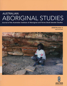
Periodical, Australian Institute of Aboriginal and Torres Strait Islander Studies, Australian Aboriginal studies : journal of the Australian Institute of Aboriginal and Torres Strait Islander Studies, 2008
Mawul Rom Project: Openness, obligation and reconciliation Morgan Brigg (Universtiy of Queensland) and Anke Tonnaer (University of Aarhus, Denmark) Aboriginal Australian initiatives to restore balanced relationships with White Australians have recently become part of reconciliation efforts. This paper provides a contextualised report on one such initiative, the Mawul Rom crosscultural mediation project. Viewing Mawul Rom as a diplomatic venture in the lineage of adjustment and earlier Rom rituals raises questions about receptiveness, individual responsibility and the role of Indigenous ceremony in reconciliation efforts. Yolngu ceremonial leaders successfully draw participants into relationship and personally commit them to the tasks of cross-cultural advocacy and reconciliation. But Mawul Rom must also negotiate a paradox because emphasis on the cultural difference of ceremony risks increasing the very social distance that the ritual attempts to confront. Managing this tension will be a key challenge if Mawul Rom is to become an effective diplomatic mechanism for cross-cultural conflict resolution and reconciliation. Living in two camps: the strategies Goldfields Aboriginal people use to manage in the customary economy and the mainstream economy at the same time Howard Sercombe (Strathclyde University, Glasgow) The economic sustainability of Aboriginal households has been a matter of public concern across a range of contexts. This research, conducted in the Eastern Goldfields of Western Australia, shows how economically successful Aboriginal persons manage ?dual economic engagement?, or involvement in the customary economy and the mainstream economy at the same time. The two economies sometimes reinforce each other but are more often in conflict, and management of conflicting obligations requires high degrees of skill and innovation. As well as creating financially sustainable households, the participants contributed significantly to the health of their extended families and communities. The research also shows that many Aboriginal people, no matter what their material and personal resources, are conscious of how fragile and unpredictable their economic lives can be, and that involvement in the customary economy is a kind of mutual insurance to guarantee survival if times get tough. Indigenous population data for evaluation and performance measurement: A cautionary note Gaminiratne Wijesekere (Dept. of Families, Housing, Community Services and Indigenous Affairs, Canberra) I outline the status of population census counts for Indigenous peoples, identifying information on Indigenous births and deaths, and internal migration estimates. I comment on the ?experimental? Indigenous population projections and question the rationale for having two sets of projections. Program managers and evaluators need to be mindful of limitations of the data when using these projections for monitoring, evaluating and measuring Indigenous programs. Reaching out to a younger generation using a 3D computer game for storytelling: Vincent Serico?s legacy Theodor G Wyeld (Flinders University, Adeliade) and Brett Leavy (CyberDreaming Australia) Sadly, Vincent Serico (1949?2008), artist, activist and humanist, recently passed away. Born in southern Queensland in Wakka Wakka/Kabi Kabi Country (Carnarvon Gorge region) in 1949, Vincent was a member of the Stolen Generations. He was separated from his family by White administration at four years of age. He grew up on the Cherbourg Aboriginal Reserve in the 1950s, when the policies of segregation and assimilation were at their peak. Only returning to his Country in his early forties, Vincent started painting his stories and the stories that had been passed on to him about the region. These paintings manifest Vincent?s sanctity for tradition, storytelling, language, spirit and beliefs. A team of researchers was honoured and fortunate to have worked closely with Vincent to develop a 3D simulation of his Country using a 3D computer game toolkit. Embedded in this simulation of his Country, in the locations that their stories speak to, are some of Vincent?s important contemporary art works. They are accompanied by a narration of Vincent?s oral history about the places, people and events depicted. Vincent was deeply concerned about members of the younger generation around him ?losing their way? in modern times. In a similar vein, Brett Leavy (Kooma) sees the 3D game engine as an opportunity to engage the younger generation in its own cultural heritage in an activity that capitalises on a common pastime. Vincent was an enthusiastic advocate of this approach. Working in consultation with Vincent and the research team, CyberDreaming developed a simulation of Vincent?s Country for young Aboriginal and non-Aboriginal persons from the Carnarvon Gorge region to explore Vincent?s life stories of the region. The use of Vincent?s contemporary paintings as storyboards provides a traditional medium for the local people to interactively re-engage with traditional values. Called Serico?s World, it represents a legacy to his life?s works, joys and regrets. Here we discuss the background to this project and Vincent?s contribution. A singular beeswax representation of Namarrkon, the Lightning Man, from western Arnhem Land RG Gunn (La Trobe University) and RL Whear (Jawoyn Association) Samples from a beeswax representation of Namarrkon, the Lightning Man, from western Arnhem Land were analysed for radiocarbon and dated to be about 150 years old. An underlying beeswax figure was found to be approximately 1100 years old. The Dreaming Being Namarrkon is well known throughout Arnhem Land, although his sphere of activity is concentrated around the northern half of the Arnhem Land plateau. Namarrkon is well represented in rock-paintings in this area and continues to be well represented in contemporary canvas-paintings by artists from the broader plateau region. We conclude that representations of Namarrkon in both painted and beeswax forms appear to be parallel manifestations of the late Holocene regionalisation of Arnhem Land. ?Missing the point? or ?what to believe ? the theory or the data?: Rationales for the production of Kimberley points Kim Akerman (Moonah) In a recent article, Rodney Harrison presented an interesting view on the role glass Kimberley points played in the lives of the Aborigines who made and used them. Harrison employed ethnographic and historical data to argue that glass Kimberley points were not part of the normal suite of post-contact artefacts used primarily for hunting and fighting or Indigenous exchange purposes, but primarily were created to service a non-Indigenous market for aesthetically pleasing artefacts. Harrison asserted that this market determined the form that these points took. A critical analysis of the data does not substantiate either of these claims. Here I do not deal with Harrison?s theoretical material or arguments; I focus on the ethnographic and historical material that he has either omitted or failed to appreciate in developing his thesis and which, in turn, renders it invalid. The intensity of raw material utilisation as an indication of occupational history in surface stone artefact assemblages from the Strathbogie Ranges, central Victoria Justin Ian Shiner (La Trobe University, Bundoora) Stone artefact assemblages are a major source of information on past human?landscape relationships throughout much of Australia. These relationships are not well understood in the Strathbogie Ranges of central Victoria, where few detailed analyses of stone artefact assemblages have been undertaken. The purpose of this paper is to redress this situation through the analysis of two surface stone artefact assemblages recorded in early 2000 during a wider investigation of the region?s potential for postgraduate archaeological fieldwork. Analysis of raw material utilisation is used to assess the characteristics of the occupational histories of two locations with similar landscape settings. The analysis indicates variability in the intensity of raw material use between the assemblages, which suggests subtle differences in the occupational history of each location. The results of this work provide a direction for future stone artefact studies within this poorly understood region.document reproductions, maps, b&w photographs, colour photographskimberley, mawul rom project, 3d computer game, storytelling, vincent serico, beeswax, namarrkon, artefact assemblages, strathbogie ranges, groote eylandt, budd billy ii -
 Flagstaff Hill Maritime Museum and Village
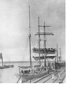
Photograph - Vessels Speculant and S. S. Flinders, Between 1902 and 1907
This photograph was one of ten photographs donated to Flagstaff Hill Maritime Museum and Village by Fred Trewartha. Frederick John Fox Trewartha (Fred) was a well-known Warrnambool businessman. He was born in Beeac near Geelong in 1920 and came to Warrnambool with his family as a very young child. He was apprenticed to his father John, as a saddler and later opened his own shop on Raglan Parade. He then moved into working with tarpaulins and canvases for the trucking industry. Fred was keenly interested in photography (and was a member of the Warrnambool Cine Club), yachting and boat building. He kept his yacht moored at Port Fairy for many years and participated in sailing events locally and interstate. He also built boats with his sons. He had the opportunity to meet many older sailors and it's thought this photo (and others in the set) may have been given to him by one of these men. Fred Trewartha died in 2016 in Warrnambool. The two identifiable ships in this picture are the "Speculant" and the "S. S. Flinders" - both coastal trading vessels that regularly came and went from Warrnambool. The third steamer on the left hasn't been identified The barquentine SPECULANT was a steel, three-masted sailing ship built in 1895 in Inverkeithing, Scotland, registered in Warrnambool, Victoria and wrecked at Cape Paton, Victoria, 10th February 1911. The SPECULANT had been involved in the timber trade between the United Kingdom and Russia, until sold to its Warrnambool owners and timber merchants Messrs. P.J. McGennan & Co. (Peter John McGennan) in 1902 for 3000 pounds and had her sailed to Warrnambool as her new port. Peter John McGennan was born in 1844 and worked as a builder and cooper in Holyhead, Anglesea, Wales. He immigrated to Australia in 1869 as a free settler and arrived in Warrnambool in 1871 and undertook management of a property in Grassmere for Mr. Palmer. Peter met his wife Emily in South Melbourne and they married in 1873. They had ten children including Harry who lived to 1965, and Andrew who lived until 1958. (The other children were their four brothers - John who was killed in the Dardenalles aged 35, Frederick who died aged 8, Peter who died aged 28, Frank who died aged 5 weeks - and four sisters - Beatrice who died age 89, Edith who died aged 49, Blanche who died aged 89 and Eveline who died aged 48.) In 1874 Peter starting a boating establishment on the Hopkins River. In 1875 he opened up a Coopers business in Kepler Street next to what was Bateman, Smith and Co., moving to Liebig Street, next to the Victoria Hotel, in 1877. In 1882 he then moved to Lava Street (which in later years was the site of Chandlers Hardware Store). He was associated with the establishment of the Butter Factory at Allansford. He started making Butter Boxes to his own design and cheese batts for the Butter Factory. In 1896 established a Box Factory in Davis Street Merrivale, employing 24 people at its peak, (it was burnt down in 1923); and in Pertobe Road from 1912 (now the Army Barracks building). Peter was a Borough Councillor for Albert Ward from 1885 to 1891, he commenced the Foreshore Trust (including the camping grounds along Pertobe Road), and he was an inaugural Director of the Woollen Mill in Harris Street, buying an extensive share-holding in 1908 from the share trader Edward Vidler. They lobbied the Town Hall to have a formal ‘Cutting’ for the waters of the Merri River to be redirected from its natural opening south of Dennington, to its existing opening near Viaduct Road, in order to have the scourings from the wool at the Woollen Mill discharged into the sea. He sold Butter Boxes around the state, and had to ship them to Melbourne by rail. Peter’s purchase of the SPECULANT in 1902 enabled him to back-load white pine from Kaipara, New Zealand to Warrnambool to make his butter boxes then, to gain profitability, buy and ship potatoes and other primary produce bound to Melbourne. (McGennan & Co. had also owned the LA BELLA, which had traded in timber as well, until she was tragically wrecked with the loss of seven lives, after missing the entrance channel to Warrnambool harbour in 1905. It appears that the SPECULANT was bought to replace the LA BELLA.) In 1911 the SPECULANT had been attempting to depart Warrnambool for almost the entire month of January to undergo docking and overhaul in Melbourne. A month of east and south-easterly winds had forced her to remain sheltered in Lady Bay, Warrnambool apart from one morning of northerlies, when an attempt was made to round Cape Otway; she had to return to shelter in Portland after failing to make any headway. With only 140 tons of sand ballast aboard, the ship would not have been easy to handle. Captain Jacobsen and his crew of nine, mainly Swedes, decided to make for Melbourne, leaving Portland Harbour on 5th February 1911. By the 9th they had reached Cape Otway, where they encountered a moonless night, constant heavy rain, and a heavy sea with a south-easterly wind blowing. After safely rounding Cape Otway the course was changed to east, then north-east to take the vessel to a point six miles off Cape Patton, following the orders of Captain Jacobsen, who told the crew to be very careful with the steering, as the wind and sea was running to leeward. The patent log (used to measure speed) had been out of order for the last four months as no-one in Warrnambool was able to fix it: it was intended to have it repaired in Melbourne. In the meantime the crew measured the vessel's speed by looking over the side and estimating wind strength. This compounded the difficulties of imprecise positioning, as the strong cross wind and sea were acting on the lightly laden vessel to steadily drive it towards the shore. At 3.30am on Friday 10 February 1911 Captain Jacobsen and the first mate were looking over the side of the vessel when they heard the sound of breakers and suddenly struck the rocks. The crew immediately knew they had no chance of getting the SPECULANT off, and attempted to rescue themselves by launching the lifeboat, which was instantly smashed to pieces. One of the crew then volunteered to take a line ashore, and the rest of the crew were all able to drag themselves to shore, some suffering hand lacerations from the rocks. Once ashore they began to walk along the coast towards Lorne, believing it was the nearest settlement. Realising their mistake as dawn broke they returned westwards to Cape Patton, and found a farm belonging to Mr C. Ramsden, who took them in and gave them a change of clothes and food. After resting for a day and returning to the wreck to salvage some of their personal possessions, at 10am on Saturday they set out for Apollo Bay, a voyage that took six hours, sometimes wading through flooded creeks up to their necks. The Age described the wreck as "listed to starboard. All the cabin is gutted and the ballast gone. There is a big rock right through the bottom of her, and there is not the slightest hope of getting her off". A Board of Marine inquiry found that Captain Jacobson was guilty of careless navigation by not taking steps to accurately verify the position of the vessel with respect to Cape Otway when the light was visible and by not setting a safe and proper course with respect to the wind and sea. It suspended his certificate for 6 months and ordered him to pay costs. The location of the wreck site was marked for a long time by two anchors on the shoreline, until in 1970 the larger of the two anchors was recovered by the Underwater Explorers' Club and mounted on the foreshore at Apollo Bay. The bell from the wreck was also donated to the Apollo Bay Surf Lifesaving Club but is recorded to have been stolen. Rusting remains of the wreck can still be found on the shoreline on the southern side of, and directly below Cape Patton. Parts of the SPECULANT site have been buried by rubble from construction and maintenance works to the Great Ocean Road, as well as by naturally occurring landslides. Peter J McGennan passed away in 1920. The Gates in the western wall of the Anglican Church in Henna Street/Koroit St are dedicated to him for his time of community work, which is matched with other prominent Warrnambool citizens; Fletcher Jones, John Younger, J.D.E (Tag) Walter, and Edward Vidler. After Peter J McGennan's death Harry, Andrew and Edith continued to operate the family business until July 11th 1923 when the company was wound up. (Andrew lived in Ryot Street Warrnambool, near Lava Street.) Harry McGennan (Peter and Emily’s son) owned the Criterion Hotel in Kepler Street Warrnambool (now demolished). His son Sid and wife Dot lived in 28 Howard Street (corner of Nelson Street) and Sid managed the Criterion until it was decided by the family to sell, and for he remained Manager for the new owners until he retired. Harry commenced the Foreshore Trust in Warrnambool around 1950. The McGennan Carpark in Pertobe Road is named after Harry and there are Memorial-Stone Gates in his memory. (The Gates were once the original entrance to the carpark but are now the exit.). The Patent Log (also called a Taffrail log) from the SPECULANT, mentioned above, and a number of photographs, are now part of the Collection at Flagstaff Hill Maritime Village.. The S. S. Flinders was built by A. J. Inglis, Ltd, Pointhouse, Glasgow in 1878 for the "Tasmanian Steam Navigation Company', Hobart which merged with the "Union Steamship Company" of New Zealand and it was later sold to the firm "McIlwraith, McEacham and Company". It was built of iron and was 1000 tons and 227 feet, 1 inch long. It was described as "splendidly fitted up for the carriage of passengers and her cargo space was also very large". In the saloon about 130 passengers could be accommodated while the second class had sufficient room for one hundred passengers. In 1890, the S. S. Flinders would leave Melbourne on Mondays and Thursdays at 5 pm and reach Warrnambool the following morning at 8 am. On the return it would leave Warrnambool on Wednesdays and Saturdays at 5 pm and reach Melbourne the following morning. In 1896, the Weekly Times described the "steamer Flinders (otherwise known as "the Warrnambool mailboat") as "as good a sample of a seagoing steamer as there is trading on the Victorian Coast at the present time". In April 1896 newspaper reports noted the S. S. Flinders took 2915 bags of potatoes from Warrnambool to Melbourne (the largest shipment of that season) as well as 50 tons of tinned rabbits from the Hamilton Preserving Factory. It was also noted that particularly during the Christmas period, there were excessive demands for berths from holiday makers wanting to enjoy a holiday in Warrnambool. In May 1903, the S. S. Flinders narrowly escaped destruction when an explosion and subsequent fire occurred during the passage from Melbourne to Warrnambool. A drum (which apparently contained carbide of calcium) exploded and blew off a hatch cover. As the steamer got to within a mile or two of Warrnambool, smoke was seen coming out of the hold and (unknown to the passengers) flames had taken hold. The crew quickly got to work - closing down all the hatches and pumping water into the hold through a hole in the saloon floor. There were 30 or 40 cases of kerosene on board. The Flinders continued on to Warrnambool and berthed at the Breakwater. The passengers all went ashore - many unaware of the danger they had been in. A telephone message was sent to the local Fire Brigade Station however the fire was extinguished before the firemen and their equipment arrived. After the hold was checked, the Flinders was certified as seaworthy and left for Portland. The Flinders continued to transport Western District produce as well as passengers from Warrnambool to Melbourne until 1906 when (due to a decrease in shipping trade during the Winter and the availability of train services) the Flinders was replaced by the smaller steamer "Dawn" and in 1907 when it was sold to the "Adelaide Steamship Company" for use in the Western Australia coastal trade, it was replaced by the "S. S. Barrabool".This photograph is a significant record of two of the well known coastal traders (the "Speculant" and the "Flinders") that sailed along the south west coast of Victoria for many years - transporting goods and passengers between Melbourne and Warrnambool.Black and white photograph of the Breakwater in Warrnambool with two ships docked and another in the bay. On the front boat (the Speculant), men can be seen at the wheel, on the deck and on the bottom two booms where they appear to be furling the sails. The sails of the top booms are already furled. A small boy can be seen on the deck and a young girl, two women and a dog are on the Breakwater. There is a steam ship (the S. S. Flinders) tied up behind the "Speculant" and an unidentified steam ship (with smoke coming from its smokestack) in the bay. There is a blue and black handwritten label on the back of the photo - naming the ships and the owner of the photo.Speculant and Flinders / Passenger ship in / Lady Bay / name of donor and phone numberflagstaff hill maritime museum and village, warrnambool, great ocean road, shipwreck coast, speculant, barque speculant, flinders, s. s. finders, steamship flinders, coastal trader, passenger ship, goods, steamer, breakwater, lady bay, warrnambool mailboat, p. j. mcgennan, peter john mcgennan, butter boxes, captain jacobsen, cape patton, tasmanian steam navigation company -
 Eltham District Historical Society Inc
Photograph - Aerial Photograph, Landata, Eltham; Crown Allotment 15, Section 5, Parish of Nillumbik (Stokes Orchard Estate), Dec. 1945
Centred on present day Diosma Rd, Stokes Pl, Nyora Rd and Eucalyptus Rd Historic Aerial Imagery Source: Landata.vic.gov.au Aerial Photo Details: Project No :5 Project : MELBOURNE AND METROPOLITAN AREA PROJECT Run : 36 Frame : 60546 Date : 12/1945 Film Type : B/W Camera : EAG4 Flying Height : 10200 Scale : 6000 Film Number : 195 GDA2020 : 37°42'47"S, 145°09'56"E MGA2020 : 338306, 5824438 (55) Melways : 22 C4 (ed. 42) A History of the Development of Crown Allotment 15, Section 5, Parish of Nillumbik – Stokes Orchard Crown Allotment 15, Section 5, Parish of Nillumbik (CA15) is a square allotment of 158 acres or approximately a quarter of a square mile. It lies just beyond the eastern end of Pitt Street, south of Nyora Road to the northern end of Eucalyptus Road and extends east from Eucalyptus Road to Reynolds Road. The topography of CA15 is generally steep, sloping up to a hill near the centre of the land, the ridgeline passing through the properties along the southern side of Diosma Road. Eucalyptus Road is a straight north-south road with its northern end at the north west corner of CA15. Until the end of the 1970s this road was an un-named Government Road and was largely not open to traffic. With residential development in the 1970s the road was constructed, and the council allocated the name obviously in recognition of the predominant species of the local bushland. CA15 was purchased from the Crown by George D’Arley Boursiquot, a prominent Melbourne printer, on 28th October 1852. On November 23, 1922, former Member for Gippsland and Melbourne Real Estate Agent, Hubert Patrick Keogh purchased the allotment then sold it March 13, 1925, to local farmer, Robert David Taylor, a former Shire of Eltham Councillor (1911-1920) and Shire President (1919). Taylor had extensive land holdings stretching west towards Bible Street and Main Road. The Taylor home was situated at the top of the hill in Bible Street at present day 82 Bible Street. At the time of Taylor’s purchase in 1925, CA15 was subdivided into 48 lots that could be described as small rural properties or large residential lots. A typical lot size was one hectare or 2.5 acres. The subdivision created two roads, Nyora Road, and Diosma Road, each following an irregular alignment between Eucalyptus and Reynolds Roads. However, the lots were not sold off separately nor were the roads constructed. The land effectively remained as one parcel for many further years. Robert David Taylor died November 30, 1934, and probate was granted to his son of the same name, Robert David Taylor of Bible Street, Salesman and William McLelland Vance Taylor of 73 Emmeline Street, Northcote, Clerk, with the transfer of the land into their names on July 8, 1935. Frank Stokes worked as a qualified accountant at Kennons leather factory in Burnley, while living at 1 Thomas Street, Mitcham. He suffered from migraines and wanted to return to working the land (he had previously worked on farms and orchards since coming to Australia from England in 1926, both in WA and Vic.). He first travelled to the district by train in July 1942 to find land with the intention to establish an orchard. By chance he met Arthur Bird of Bird Orchard (bounded by Pitt Street, Eucalyptus Road, and Wattle Grove) and they got talking over their common interest. Arthur put Frank up for the night and pointed out the land, 158 acres- part of the Taylor Estate- £900, Crown Allotment 15, Section 5, Parish of Nillumbik (CA15) somewhat diagonally opposite Bird Orchard. Stokes applied through the Riverina Agency to purchase the land who in turn applied for permission from Canberra to sell as there was a new government regulation introduced during the Second World War banning land sales except for immediate production. Stokes obtained a loan on his Mitcham house of £600 @ 5% and paid £450 deposit with quarterly payments of £15 spread over 5 years. Stokes was assisted and advised by Arthur Bird who farmed the neighbouring orchard. In early 1943 Stokes took possession and would catch the train out to Eltham on Fridays after work and began building a hut on the corner of Nyora Road and the Government Road (Eucalyptus Road) for shelter and to lock up tools. He established an orchard on the central western part of the land through the centre of which ran a natural waterway (part of the present-day linear park) and was able to pay a neighbour (Hawkins) to help with clearing and fencing 25 acres, and with a horse and single furrowed plough, planted approximately 2,500 fruit trees - cherries, peaches, plums, almonds, pears, apricots and lemons as well as a few apples and oranges; a massive task. Aerial photographs from the 1940s through to the 1990s clearly show the orchard with most of the larger CA15 site remaining as natural bushland. A huge problem was hares and rabbits eating all the new buds off the tiny trees. As well as laying poison he painted the trees with a mixture of cow manure and lime, often working by moonlight. Procurement of wire and wire netting was difficult because of the war but after much effort he obtained a permit from the Agricultural Department for supplies in March 1944. In February 1945 Stokes applied for a permit to build a “packing shed” as no house building was allowed. It was to be 33 feet x 21 feet and cost £312. It was constructed mostly from second-hand materials, which were hard to obtain, especially iron for roofing. Stokes finished work at Kennons on October 31, 1945, and in March 1946 he sold the family home at Mitcham for £1,230 plus £170 for furniture. On May 15, 1946, title to the CA15 property was issued to Frank Howard Alfred Stokes, Orchardist and Gladys Ethel Stokes, Married Woman, both of Pitt Street, Eltham. The family of five then moved into the very unfinished “packing shed” at Eltham, which was a struggle to weatherproof. Eventually rooms were divided off and lined with hessian bags and whitewashed. Their income was firewood (cut and sold), selling rockery stones and cut Sweet Bursaria. (It was discovered during the 1940s that Sweet Bursaria contained the sunscreen compound Aesculin. The RAAF utilised this compound from Sweet Bursaria during WW2 for pilots and gunners.) The orchard’s first fruit sale was a half-case of Le Vanq peaches in December 1947 for the price of 8 shillings. In 1956 plans for house were drawn and Glen Iris bricks purchased (1956 Olympic Rings variant). The building of the house commenced in 1957 - 12 feet of original packing shed was removed – and was completed in 1959. Water was connected from newly built pressure storage on the property at the end of 1959 and the electricity connection for the first time at 3pm on April 29, 1960. The house remains to present day (somewhat modified) at 1 Nyora Road, home to Nyora Studio Gallery. On occasions, spare remnants of the 1956 bricks have been known to be unearthed in gardens on the estate as they were utilised by Frank Stokes to fill in rabbit holes. On May 26, 1950, a parcel of land was compulsorily acquired by the Melbourne and Metropolitan Board of Works on the hilltop to establish an easement for a high-level service reservoir to augment Eltham’s water supply. The project also included pipe tracks for the necessary water mains. The reservoir has now been superseded by higher level water tanks east of Reynolds Road and its former site is now a public reserve. On November 27, 1964, the State Electricity Commission served notice to compulsorily acquire a further parcel through the eastern part of the land for a major electricity transmission line that augmented supply from the La Trobe Valley to Melbourne. The easement was registered February 11, 1966. The easement was widened July 18, 1969 for a second transmission line to be constructed. In 1971 Melbourne Metropolitan Planning Scheme amendments adopted Nyora Road as the boundary between a residential zone to the north and a rural zone to the south. This determined the future development of the land. In the mid-1970s the Shire of Eltham divided the orchard into numerous rate-able parcel lots, the 48 lots having been established in 1925 and the subsequent rates assessment proved unsustainable for Stokes. He commenced selling lots outside the boundary of the orchard, north of Diosma and South of Nyora. However shortly later the land between Nyora and Diosma Roads and west of the electricity easement was sold and subdivided into residential lots, a housing development by Macquarie Builders and marketed as the Stokes Orchard Estate. New streets were created, and most were named after trees, although one, Stokes Place, commemorates the former owners. The development was undertaken in two stages; Stage 1 (1975) encompassing Scarlet Ash Court, Ironbark Close and Peppermint Grove bounded by Nyora and Eucalyptus roads and Stage 2 (1978) encompassing Stokes Place, Orchard Way, The Crest and The Lookout bound by Nyora and Diosma roads. The developer, Macquarie Builders went bankrupt shortly after the release of Stage 2 leaving many purchasers to fend for themselves and arrange for their own independent builders. There were also difficulties with sewerage for the land immediately south of Diosma Road and so the conventional residential lots were abandoned in favour of larger lots. The development of Orchard Way, The Crest and The Lookout did not proceed as planned and the proposed lots were incorporated into five-acre parcels instead. These included a low-density group housing development by the Graves family and the award winning Choong House (1983) with Gordon Ford developed garden immediately next door situated on the ridge of the hill nestled amongst the original bush, Eucalypt trees and Sweet Bursaria. In 1994, Nillumbik Shire Council applied Significant Environment and Significant Landscape overlays upon the properties on the south side of Diosma Road to ensure protection of this natural bush garden environment. With the arrival of the sewer along Diosma Road in the 1990s, most of these five-acre parcels have since been subdivided multiple times. The Choong house presently sits on a 2.7-acre property, which in 2022 Nillumbik Council nominated for Cultural Significance Heritage protection and is considered potentially significant at State level. The Stokes family were also associated with the Eltham Christian Church. In the 1970s this church had met in temporary premises in Eltham. Lots of the original 1925 subdivision remained south of Nyora Road and a number of these lots were utilized for the Eltham Christian School, which was established by the Eltham Christian Church in 1981. The school operated on this site until 2000. The premises are now used by The Vine Baptist Church. By the mid-1980s the whole of CA15 had been developed for residential and school purposes, except for the sections north of Diosma Road and between the transmission lines and Reynolds Road. Sewerage issues had been resolved for the section north of Diosma Road and in 1987 it was in the process of being subdivided into residential lots. The development coincided with the discovery of colonies of the rare and endangered Eltham Copper Butterfly on the site. This resulted in a community and political campaign to save the butterfly habitat. With the co-operation of the land developer the subdivision was altered to create two bushland reserves in the critical butterfly habitat areas. In the late 1980s the State Government was investigating options for establishing a metropolitan ring road link between Diamond Creek and Ringwood. The chosen route was adjacent to Reynolds Road and so this created a freeze on development of CA15 between Reynolds Road and the electricity easement. The ring road proposal was eventually abandoned, and this part of the land was subdivided into low density residential lots. Diosma Road has been discontinued at the electricity easement and the eastern part incorporated into View Mount Court with access from Reynolds Road. The whole of CA15 has now been developed for residential or associated purposes, ranging from conventional density to quite low density south of Nyora Road. Some remnants of the orchard remain, a few cherry trees on the Graves property and a lone apple tree in Stokes Place. The butterfly reserves comprise significant areas of remnant bushland. Linear reserves through the estate link with central Eltham via the Woodridge linear reserve and with Research along the electricity easement. CA15 as it exists today has a complicated history of rural use, Government acquisition, urban development, and community action. References: • “Stokes Orchard, an incomplete history”; Russell Yeoman with Doug Orford • Correspondence, Beryl Bradbury (nee Stokes) • Aerial Photographs, 1931-1991, Landata (landata.vic.gov.au) • Certificate of Title, Vol. 4930 Fol. 985900 • Plan Number LP 10859 aerial photo, diosma road, eltham copper butterfly, eucalyptus road, ironbark close, nyora road, peppermint grove, peter & elizabeth pidgeon collection, power transmission lines, reynolds road, scarlet ash court, stokes orchard estate, stokes place, woodridge estate, frank stokes -
 Eltham District Historical Society Inc
Photograph - Aerial Photograph, Landata, Eltham; Crown Allotment 15, Section 5, Parish of Nillumbik (Stokes Orchard Estate), Nov. 1931
Centred over present day Reynolds Road and Mount Pleasant Road, Eltham (including Diosma Rd, Stokes Pl, Nyora Rd and Eucalyptus Rd) Historic Aerial Imagery Source: Landata.vic.gov.au Aerial Photo Details: Project No :1931 Project : MALDON PRISON Run : 21 Frame : 3160 Date : 11/1931 Film Type : B/W Camera : F8 Flying Height : 11000 Scale : 18860 Film Number : 60 GDA2020 : 37°43'31"S, 145°10'20"E MGA2020 : 338912, 5823086 (55) Melways : 22 E8 (ed. 42) A History of the Development of Crown Allotment 15, Section 5, Parish of Nillumbik – Stokes Orchard Crown Allotment 15, Section 5, Parish of Nillumbik (CA15) is a square allotment of 158 acres or approximately a quarter of a square mile. It lies just beyond the eastern end of Pitt Street, south of Nyora Road to the northern end of Eucalyptus Road and extends east from Eucalyptus Road to Reynolds Road. The topography of CA15 is generally steep, sloping up to a hill near the centre of the land, the ridgeline passing through the properties along the southern side of Diosma Road. Eucalyptus Road is a straight north-south road with its northern end at the north west corner of CA15. Until the end of the 1970s this road was an un-named Government Road and was largely not open to traffic. With residential development in the 1970s the road was constructed, and the council allocated the name obviously in recognition of the predominant species of the local bushland. CA15 was purchased from the Crown by George D’Arley Boursiquot, a prominent Melbourne printer, on 28th October 1852. On November 23, 1922, former Member for Gippsland and Melbourne Real Estate Agent, Hubert Patrick Keogh purchased the allotment then sold it March 13, 1925, to local farmer, Robert David Taylor, a former Shire of Eltham Councillor (1911-1920) and Shire President (1919). Taylor had extensive land holdings stretching west towards Bible Street and Main Road. The Taylor home was situated at the top of the hill in Bible Street at present day 82 Bible Street. At the time of Taylor’s purchase in 1925, CA15 was subdivided into 48 lots that could be described as small rural properties or large residential lots. A typical lot size was one hectare or 2.5 acres. The subdivision created two roads, Nyora Road, and Diosma Road, each following an irregular alignment between Eucalyptus and Reynolds Roads. However, the lots were not sold off separately nor were the roads constructed. The land effectively remained as one parcel for many further years. Robert David Taylor died November 30, 1934, and probate was granted to his son of the same name, Robert David Taylor of Bible Street, Salesman and William McLelland Vance Taylor of 73 Emmeline Street, Northcote, Clerk, with the transfer of the land into their names on July 8, 1935. Frank Stokes worked as a qualified accountant at Kennons leather factory in Burnley, while living at 1 Thomas Street, Mitcham. He suffered from migraines and wanted to return to working the land (he had previously worked on farms and orchards since coming to Australia from England in 1926, both in WA and Vic.). He first travelled to the district by train in July 1942 to find land with the intention to establish an orchard. By chance he met Arthur Bird of Bird Orchard (bounded by Pitt Street, Eucalyptus Road, and Wattle Grove) and they got talking over their common interest. Arthur put Frank up for the night and pointed out the land, 158 acres- part of the Taylor Estate- £900, Crown Allotment 15, Section 5, Parish of Nillumbik (CA15) somewhat diagonally opposite Bird Orchard. Stokes applied through the Riverina Agency to purchase the land who in turn applied for permission from Canberra to sell as there was a new government regulation introduced during the Second World War banning land sales except for immediate production. Stokes obtained a loan on his Mitcham house of £600 @ 5% and paid £450 deposit with quarterly payments of £15 spread over 5 years. Stokes was assisted and advised by Arthur Bird who farmed the neighbouring orchard. In early 1943 Stokes took possession and would catch the train out to Eltham on Fridays after work and began building a hut on the corner of Nyora Road and the Government Road (Eucalyptus Road) for shelter and to lock up tools. He established an orchard on the central western part of the land through the centre of which ran a natural waterway (part of the present-day linear park) and was able to pay a neighbour (Hawkins) to help with clearing and fencing 25 acres, and with a horse and single furrowed plough, planted approximately 2,500 fruit trees - cherries, peaches, plums, almonds, pears, apricots and lemons as well as a few apples and oranges; a massive task. Aerial photographs from the 1940s through to the 1990s clearly show the orchard with most of the larger CA15 site remaining as natural bushland. A huge problem was hares and rabbits eating all the new buds off the tiny trees. As well as laying poison he painted the trees with a mixture of cow manure and lime, often working by moonlight. Procurement of wire and wire netting was difficult because of the war but after much effort he obtained a permit from the Agricultural Department for supplies in March 1944. In February 1945 Stokes applied for a permit to build a “packing shed” as no house building was allowed. It was to be 33 feet x 21 feet and cost £312. It was constructed mostly from second-hand materials, which were hard to obtain, especially iron for roofing. Stokes finished work at Kennons on October 31, 1945, and in March 1946 he sold the family home at Mitcham for £1,230 plus £170 for furniture. On May 15, 1946, title to the CA15 property was issued to Frank Howard Alfred Stokes, Orchardist and Gladys Ethel Stokes, Married Woman, both of Pitt Street, Eltham. The family of five then moved into the very unfinished “packing shed” at Eltham, which was a struggle to weatherproof. Eventually rooms were divided off and lined with hessian bags and whitewashed. Their income was firewood (cut and sold), selling rockery stones and cut Sweet Bursaria. (It was discovered during the 1940s that Sweet Bursaria contained the sunscreen compound Aesculin. The RAAF utilised this compound from Sweet Bursaria during WW2 for pilots and gunners.) The orchard’s first fruit sale was a half-case of Le Vanq peaches in December 1947 for the price of 8 shillings. In 1956 plans for house were drawn and Glen Iris bricks purchased (1956 Olympic Rings variant). The building of the house commenced in 1957 - 12 feet of original packing shed was removed – and was completed in 1959. Water was connected from newly built pressure storage on the property at the end of 1959 and the electricity connection for the first time at 3pm on April 29, 1960. The house remains to present day (somewhat modified) at 1 Nyora Road, home to Nyora Studio Gallery. On occasions, spare remnants of the 1956 bricks have been known to be unearthed in gardens on the estate as they were utilised by Frank Stokes to fill in rabbit holes. On May 26, 1950, a parcel of land was compulsorily acquired by the Melbourne and Metropolitan Board of Works on the hilltop to establish an easement for a high-level service reservoir to augment Eltham’s water supply. The project also included pipe tracks for the necessary water mains. The reservoir has now been superseded by higher level water tanks east of Reynolds Road and its former site is now a public reserve. On November 27, 1964, the State Electricity Commission served notice to compulsorily acquire a further parcel through the eastern part of the land for a major electricity transmission line that augmented supply from the La Trobe Valley to Melbourne. The easement was registered February 11, 1966. The easement was widened July 18, 1969 for a second transmission line to be constructed. In 1971 Melbourne Metropolitan Planning Scheme amendments adopted Nyora Road as the boundary between a residential zone to the north and a rural zone to the south. This determined the future development of the land. In the mid-1970s the Shire of Eltham divided the orchard into numerous rate-able parcel lots, the 48 lots having been established in 1925 and the subsequent rates assessment proved unsustainable for Stokes. He commenced selling lots outside the boundary of the orchard, north of Diosma and South of Nyora. However shortly later the land between Nyora and Diosma Roads and west of the electricity easement was sold and subdivided into residential lots, a housing development by Macquarie Builders and marketed as the Stokes Orchard Estate. New streets were created, and most were named after trees, although one, Stokes Place, commemorates the former owners. The development was undertaken in two stages; Stage 1 (1975) encompassing Scarlet Ash Court, Ironbark Close and Peppermint Grove bounded by Nyora and Eucalyptus roads and Stage 2 (1978) encompassing Stokes Place, Orchard Way, The Crest and The Lookout bound by Nyora and Diosma roads. The developer, Macquarie Builders went bankrupt shortly after the release of Stage 2 leaving many purchasers to fend for themselves and arrange for their own independent builders. There were also difficulties with sewerage for the land immediately south of Diosma Road and so the conventional residential lots were abandoned in favour of larger lots. The development of Orchard Way, The Crest and The Lookout did not proceed as planned and the proposed lots were incorporated into five-acre parcels instead. These included a low-density group housing development by the Graves family and the award winning Choong House (1983) with Gordon Ford developed garden immediately next door situated on the ridge of the hill nestled amongst the original bush, Eucalypt trees and Sweet Bursaria. In 1994, Nillumbik Shire Council applied Significant Environment and Significant Landscape overlays upon the properties on the south side of Diosma Road to ensure protection of this natural bush garden environment. With the arrival of the sewer along Diosma Road in the 1990s, most of these five-acre parcels have since been subdivided multiple times. The Choong house presently sits on a 2.7-acre property, which in 2022 Nillumbik Council nominated for Cultural Significance Heritage protection and is considered potentially significant at State level. The Stokes family were also associated with the Eltham Christian Church. In the 1970s this church had met in temporary premises in Eltham. Lots of the original 1925 subdivision remained south of Nyora Road and a number of these lots were utilized for the Eltham Christian School, which was established by the Eltham Christian Church in 1981. The school operated on this site until 2000. The premises are now used by The Vine Baptist Church. By the mid-1980s the whole of CA15 had been developed for residential and school purposes, except for the sections north of Diosma Road and between the transmission lines and Reynolds Road. Sewerage issues had been resolved for the section north of Diosma Road and in 1987 it was in the process of being subdivided into residential lots. The development coincided with the discovery of colonies of the rare and endangered Eltham Copper Butterfly on the site. This resulted in a community and political campaign to save the butterfly habitat. With the co-operation of the land developer the subdivision was altered to create two bushland reserves in the critical butterfly habitat areas. In the late 1980s the State Government was investigating options for establishing a metropolitan ring road link between Diamond Creek and Ringwood. The chosen route was adjacent to Reynolds Road and so this created a freeze on development of CA15 between Reynolds Road and the electricity easement. The ring road proposal was eventually abandoned, and this part of the land was subdivided into low density residential lots. Diosma Road has been discontinued at the electricity easement and the eastern part incorporated into View Mount Court with access from Reynolds Road. The whole of CA15 has now been developed for residential or associated purposes, ranging from conventional density to quite low density south of Nyora Road. Some remnants of the orchard remain, a few cherry trees on the Graves property and a lone apple tree in Stokes Place. The butterfly reserves comprise significant areas of remnant bushland. Linear reserves through the estate link with central Eltham via the Woodridge linear reserve and with Research along the electricity easement. CA15 as it exists today has a complicated history of rural use, Government acquisition, urban development, and community action. References: • “Stokes Orchard, an incomplete history”; Russell Yeoman with Doug Orford • Correspondence, Beryl Bradbury (nee Stokes) • Aerial Photographs, 1931-1991, Landata (landata.vic.gov.au) • Certificate of Title, Vol. 4930 Fol. 985900 • Plan Number LP 10859 aerial photo, diosma road, eltham copper butterfly, eucalyptus road, ironbark close, nyora road, peppermint grove, peter & elizabeth pidgeon collection, power transmission lines, reynolds road, scarlet ash court, stokes orchard estate, stokes place, woodridge estate, frank stokes -
 Eltham District Historical Society Inc
Photograph - Aerial Photograph, Landata, Eltham; Crown Allotment 15, Section 5, Parish of Nillumbik (Stokes Orchard Estate), Jan. 1951
Centred on present day Diosma Rd, Stokes Pl, Nyora Rd and Eucalyptus Rd Historic Aerial Imagery Source: Landata.vic.gov.au Aerial Photo Details: Project No :65 Project : MELBOURNE AND METROPOLITAN PROJECT NO. 2 Run : 8 Frame : 71 Date : 01/1951 Film Type : B/W Camera : EAG9 Flying Height : 12200 Scale : 12000 Film Number : 1419 GDA2020 : 37°43'14"S, 145°09'46"E MGA2020 : 338081, 5823608 (55) Melways : 22 C6 (ed. 42) A History of the Development of Crown Allotment 15, Section 5, Parish of Nillumbik – Stokes Orchard Crown Allotment 15, Section 5, Parish of Nillumbik (CA15) is a square allotment of 158 acres or approximately a quarter of a square mile. It lies just beyond the eastern end of Pitt Street, south of Nyora Road to the northern end of Eucalyptus Road and extends east from Eucalyptus Road to Reynolds Road. The topography of CA15 is generally steep, sloping up to a hill near the centre of the land, the ridgeline passing through the properties along the southern side of Diosma Road. Eucalyptus Road is a straight north-south road with its northern end at the north west corner of CA15. Until the end of the 1970s this road was an un-named Government Road and was largely not open to traffic. With residential development in the 1970s the road was constructed, and the council allocated the name obviously in recognition of the predominant species of the local bushland. CA15 was purchased from the Crown by George D’Arley Boursiquot, a prominent Melbourne printer, on 28th October 1852. On November 23, 1922, former Member for Gippsland and Melbourne Real Estate Agent, Hubert Patrick Keogh purchased the allotment then sold it March 13, 1925, to local farmer, Robert David Taylor, a former Shire of Eltham Councillor (1911-1920) and Shire President (1919). Taylor had extensive land holdings stretching west towards Bible Street and Main Road. The Taylor home was situated at the top of the hill in Bible Street at present day 82 Bible Street. At the time of Taylor’s purchase in 1925, CA15 was subdivided into 48 lots that could be described as small rural properties or large residential lots. A typical lot size was one hectare or 2.5 acres. The subdivision created two roads, Nyora Road, and Diosma Road, each following an irregular alignment between Eucalyptus and Reynolds Roads. However, the lots were not sold off separately nor were the roads constructed. The land effectively remained as one parcel for many further years. Robert David Taylor died November 30, 1934, and probate was granted to his son of the same name, Robert David Taylor of Bible Street, Salesman and William McLelland Vance Taylor of 73 Emmeline Street, Northcote, Clerk, with the transfer of the land into their names on July 8, 1935. Frank Stokes worked as a qualified accountant at Kennons leather factory in Burnley, while living at 1 Thomas Street, Mitcham. He suffered from migraines and wanted to return to working the land (he had previously worked on farms and orchards since coming to Australia from England in 1926, both in WA and Vic.). He first travelled to the district by train in July 1942 to find land with the intention to establish an orchard. By chance he met Arthur Bird of Bird Orchard (bounded by Pitt Street, Eucalyptus Road, and Wattle Grove) and they got talking over their common interest. Arthur put Frank up for the night and pointed out the land, 158 acres- part of the Taylor Estate- £900, Crown Allotment 15, Section 5, Parish of Nillumbik (CA15) somewhat diagonally opposite Bird Orchard. Stokes applied through the Riverina Agency to purchase the land who in turn applied for permission from Canberra to sell as there was a new government regulation introduced during the Second World War banning land sales except for immediate production. Stokes obtained a loan on his Mitcham house of £600 @ 5% and paid £450 deposit with quarterly payments of £15 spread over 5 years. Stokes was assisted and advised by Arthur Bird who farmed the neighbouring orchard. In early 1943 Stokes took possession and would catch the train out to Eltham on Fridays after work and began building a hut on the corner of Nyora Road and the Government Road (Eucalyptus Road) for shelter and to lock up tools. He established an orchard on the central western part of the land through the centre of which ran a natural waterway (part of the present-day linear park) and was able to pay a neighbour (Hawkins) to help with clearing and fencing 25 acres, and with a horse and single furrowed plough, planted approximately 2,500 fruit trees - cherries, peaches, plums, almonds, pears, apricots and lemons as well as a few apples and oranges; a massive task. Aerial photographs from the 1940s through to the 1990s clearly show the orchard with most of the larger CA15 site remaining as natural bushland. A huge problem was hares and rabbits eating all the new buds off the tiny trees. As well as laying poison he painted the trees with a mixture of cow manure and lime, often working by moonlight. Procurement of wire and wire netting was difficult because of the war but after much effort he obtained a permit from the Agricultural Department for supplies in March 1944. In February 1945 Stokes applied for a permit to build a “packing shed” as no house building was allowed. It was to be 33 feet x 21 feet and cost £312. It was constructed mostly from second-hand materials, which were hard to obtain, especially iron for roofing. Stokes finished work at Kennons on October 31, 1945, and in March 1946 he sold the family home at Mitcham for £1,230 plus £170 for furniture. On May 15, 1946, title to the CA15 property was issued to Frank Howard Alfred Stokes, Orchardist and Gladys Ethel Stokes, Married Woman, both of Pitt Street, Eltham. The family of five then moved into the very unfinished “packing shed” at Eltham, which was a struggle to weatherproof. Eventually rooms were divided off and lined with hessian bags and whitewashed. Their income was firewood (cut and sold), selling rockery stones and cut Sweet Bursaria. (It was discovered during the 1940s that Sweet Bursaria contained the sunscreen compound Aesculin. The RAAF utilised this compound from Sweet Bursaria during WW2 for pilots and gunners.) The orchard’s first fruit sale was a half-case of Le Vanq peaches in December 1947 for the price of 8 shillings. In 1956 plans for house were drawn and Glen Iris bricks purchased (1956 Olympic Rings variant). The building of the house commenced in 1957 - 12 feet of original packing shed was removed – and was completed in 1959. Water was connected from newly built pressure storage on the property at the end of 1959 and the electricity connection for the first time at 3pm on April 29, 1960. The house remains to present day (somewhat modified) at 1 Nyora Road, home to Nyora Studio Gallery. On occasions, spare remnants of the 1956 bricks have been known to be unearthed in gardens on the estate as they were utilised by Frank Stokes to fill in rabbit holes. On May 26, 1950, a parcel of land was compulsorily acquired by the Melbourne and Metropolitan Board of Works on the hilltop to establish an easement for a high-level service reservoir to augment Eltham’s water supply. The project also included pipe tracks for the necessary water mains. The reservoir has now been superseded by higher level water tanks east of Reynolds Road and its former site is now a public reserve. On November 27, 1964, the State Electricity Commission served notice to compulsorily acquire a further parcel through the eastern part of the land for a major electricity transmission line that augmented supply from the La Trobe Valley to Melbourne. The easement was registered February 11, 1966. The easement was widened July 18, 1969 for a second transmission line to be constructed. In 1971 Melbourne Metropolitan Planning Scheme amendments adopted Nyora Road as the boundary between a residential zone to the north and a rural zone to the south. This determined the future development of the land. In the mid-1970s the Shire of Eltham divided the orchard into numerous rate-able parcel lots, the 48 lots having been established in 1925 and the subsequent rates assessment proved unsustainable for Stokes. He commenced selling lots outside the boundary of the orchard, north of Diosma and South of Nyora. However shortly later the land between Nyora and Diosma Roads and west of the electricity easement was sold and subdivided into residential lots, a housing development by Macquarie Builders and marketed as the Stokes Orchard Estate. New streets were created, and most were named after trees, although one, Stokes Place, commemorates the former owners. The development was undertaken in two stages; Stage 1 (1975) encompassing Scarlet Ash Court, Ironbark Close and Peppermint Grove bounded by Nyora and Eucalyptus roads and Stage 2 (1978) encompassing Stokes Place, Orchard Way, The Crest and The Lookout bound by Nyora and Diosma roads. The developer, Macquarie Builders went bankrupt shortly after the release of Stage 2 leaving many purchasers to fend for themselves and arrange for their own independent builders. There were also difficulties with sewerage for the land immediately south of Diosma Road and so the conventional residential lots were abandoned in favour of larger lots. The development of Orchard Way, The Crest and The Lookout did not proceed as planned and the proposed lots were incorporated into five-acre parcels instead. These included a low-density group housing development by the Graves family and the award winning Choong House (1983) with Gordon Ford developed garden immediately next door situated on the ridge of the hill nestled amongst the original bush, Eucalypt trees and Sweet Bursaria. In 1994, Nillumbik Shire Council applied Significant Environment and Significant Landscape overlays upon the properties on the south side of Diosma Road to ensure protection of this natural bush garden environment. With the arrival of the sewer along Diosma Road in the 1990s, most of these five-acre parcels have since been subdivided multiple times. The Choong house presently sits on a 2.7-acre property, which in 2022 Nillumbik Council nominated for Cultural Significance Heritage protection and is considered potentially significant at State level. The Stokes family were also associated with the Eltham Christian Church. In the 1970s this church had met in temporary premises in Eltham. Lots of the original 1925 subdivision remained south of Nyora Road and a number of these lots were utilized for the Eltham Christian School, which was established by the Eltham Christian Church in 1981. The school operated on this site until 2000. The premises are now used by The Vine Baptist Church. By the mid-1980s the whole of CA15 had been developed for residential and school purposes, except for the sections north of Diosma Road and between the transmission lines and Reynolds Road. Sewerage issues had been resolved for the section north of Diosma Road and in 1987 it was in the process of being subdivided into residential lots. The development coincided with the discovery of colonies of the rare and endangered Eltham Copper Butterfly on the site. This resulted in a community and political campaign to save the butterfly habitat. With the co-operation of the land developer the subdivision was altered to create two bushland reserves in the critical butterfly habitat areas. In the late 1980s the State Government was investigating options for establishing a metropolitan ring road link between Diamond Creek and Ringwood. The chosen route was adjacent to Reynolds Road and so this created a freeze on development of CA15 between Reynolds Road and the electricity easement. The ring road proposal was eventually abandoned, and this part of the land was subdivided into low density residential lots. Diosma Road has been discontinued at the electricity easement and the eastern part incorporated into View Mount Court with access from Reynolds Road. The whole of CA15 has now been developed for residential or associated purposes, ranging from conventional density to quite low density south of Nyora Road. Some remnants of the orchard remain, a few cherry trees on the Graves property and a lone apple tree in Stokes Place. The butterfly reserves comprise significant areas of remnant bushland. Linear reserves through the estate link with central Eltham via the Woodridge linear reserve and with Research along the electricity easement. CA15 as it exists today has a complicated history of rural use, Government acquisition, urban development, and community action. References: • “Stokes Orchard, an incomplete history”; Russell Yeoman with Doug Orford • Correspondence, Beryl Bradbury (nee Stokes) • Aerial Photographs, 1931-1991, Landata (landata.vic.gov.au) • Certificate of Title, Vol. 4930 Fol. 985900 • Plan Number LP 10859 aerial photo, diosma road, eltham copper butterfly, eucalyptus road, ironbark close, nyora road, peppermint grove, peter & elizabeth pidgeon collection, power transmission lines, reynolds road, scarlet ash court, stokes orchard estate, stokes place, woodridge estate, frank stokes -
 Eltham District Historical Society Inc
Photograph - Aerial Photograph, Landata, Eltham; Crown Allotment 15, Section 5, Parish of Nillumbik (Stokes Orchard Estate), Feb. 1956
Centred on present day Diosma Rd, Stokes Pl, Nyora Rd and Eucalyptus Rd Historic Aerial Imagery Source: Landata.vic.gov.au Aerial Photo Details: Project No :250 Project : MELBOURNE OUTER SUBURBS PROJECT Run : 18 Frame : 94 Date : 02/1956 Film Type : B/W Camera : EAG9 Flying Height : 10000 Scale : 12000 Film Number : 1176 GDA2020 : 37°42'30"S, 145°09'44"E MGA2020 : 338008, 5824963 (55) Melways : 22 C3 (ed. 42) A History of the Development of Crown Allotment 15, Section 5, Parish of Nillumbik – Stokes Orchard Crown Allotment 15, Section 5, Parish of Nillumbik (CA15) is a square allotment of 158 acres or approximately a quarter of a square mile. It lies just beyond the eastern end of Pitt Street, south of Nyora Road to the northern end of Eucalyptus Road and extends east from Eucalyptus Road to Reynolds Road. The topography of CA15 is generally steep, sloping up to a hill near the centre of the land, the ridgeline passing through the properties along the southern side of Diosma Road. Eucalyptus Road is a straight north-south road with its northern end at the north west corner of CA15. Until the end of the 1970s this road was an un-named Government Road and was largely not open to traffic. With residential development in the 1970s the road was constructed, and the council allocated the name obviously in recognition of the predominant species of the local bushland. CA15 was purchased from the Crown by George D’Arley Boursiquot, a prominent Melbourne printer, on 28th October 1852. On November 23, 1922, former Member for Gippsland and Melbourne Real Estate Agent, Hubert Patrick Keogh purchased the allotment then sold it March 13, 1925, to local farmer, Robert David Taylor, a former Shire of Eltham Councillor (1911-1920) and Shire President (1919). Taylor had extensive land holdings stretching west towards Bible Street and Main Road. The Taylor home was situated at the top of the hill in Bible Street at present day 82 Bible Street. At the time of Taylor’s purchase in 1925, CA15 was subdivided into 48 lots that could be described as small rural properties or large residential lots. A typical lot size was one hectare or 2.5 acres. The subdivision created two roads, Nyora Road, and Diosma Road, each following an irregular alignment between Eucalyptus and Reynolds Roads. However, the lots were not sold off separately nor were the roads constructed. The land effectively remained as one parcel for many further years. Robert David Taylor died November 30, 1934, and probate was granted to his son of the same name, Robert David Taylor of Bible Street, Salesman and William McLelland Vance Taylor of 73 Emmeline Street, Northcote, Clerk, with the transfer of the land into their names on July 8, 1935. Frank Stokes worked as a qualified accountant at Kennons leather factory in Burnley, while living at 1 Thomas Street, Mitcham. He suffered from migraines and wanted to return to working the land (he had previously worked on farms and orchards since coming to Australia from England in 1926, both in WA and Vic.). He first travelled to the district by train in July 1942 to find land with the intention to establish an orchard. By chance he met Arthur Bird of Bird Orchard (bounded by Pitt Street, Eucalyptus Road, and Wattle Grove) and they got talking over their common interest. Arthur put Frank up for the night and pointed out the land, 158 acres- part of the Taylor Estate- £900, Crown Allotment 15, Section 5, Parish of Nillumbik (CA15) somewhat diagonally opposite Bird Orchard. Stokes applied through the Riverina Agency to purchase the land who in turn applied for permission from Canberra to sell as there was a new government regulation introduced during the Second World War banning land sales except for immediate production. Stokes obtained a loan on his Mitcham house of £600 @ 5% and paid £450 deposit with quarterly payments of £15 spread over 5 years. Stokes was assisted and advised by Arthur Bird who farmed the neighbouring orchard. In early 1943 Stokes took possession and would catch the train out to Eltham on Fridays after work and began building a hut on the corner of Nyora Road and the Government Road (Eucalyptus Road) for shelter and to lock up tools. He established an orchard on the central western part of the land through the centre of which ran a natural waterway (part of the present-day linear park) and was able to pay a neighbour (Hawkins) to help with clearing and fencing 25 acres, and with a horse and single furrowed plough, planted approximately 2,500 fruit trees - cherries, peaches, plums, almonds, pears, apricots and lemons as well as a few apples and oranges; a massive task. Aerial photographs from the 1940s through to the 1990s clearly show the orchard with most of the larger CA15 site remaining as natural bushland. A huge problem was hares and rabbits eating all the new buds off the tiny trees. As well as laying poison he painted the trees with a mixture of cow manure and lime, often working by moonlight. Procurement of wire and wire netting was difficult because of the war but after much effort he obtained a permit from the Agricultural Department for supplies in March 1944. In February 1945 Stokes applied for a permit to build a “packing shed” as no house building was allowed. It was to be 33 feet x 21 feet and cost £312. It was constructed mostly from second-hand materials, which were hard to obtain, especially iron for roofing. Stokes finished work at Kennons on October 31, 1945, and in March 1946 he sold the family home at Mitcham for £1,230 plus £170 for furniture. On May 15, 1946, title to the CA15 property was issued to Frank Howard Alfred Stokes, Orchardist and Gladys Ethel Stokes, Married Woman, both of Pitt Street, Eltham. The family of five then moved into the very unfinished “packing shed” at Eltham, which was a struggle to weatherproof. Eventually rooms were divided off and lined with hessian bags and whitewashed. Their income was firewood (cut and sold), selling rockery stones and cut Sweet Bursaria. (It was discovered during the 1940s that Sweet Bursaria contained the sunscreen compound Aesculin. The RAAF utilised this compound from Sweet Bursaria during WW2 for pilots and gunners.) The orchard’s first fruit sale was a half-case of Le Vanq peaches in December 1947 for the price of 8 shillings. In 1956 plans for house were drawn and Glen Iris bricks purchased (1956 Olympic Rings variant). The building of the house commenced in 1957 - 12 feet of original packing shed was removed – and was completed in 1959. Water was connected from newly built pressure storage on the property at the end of 1959 and the electricity connection for the first time at 3pm on April 29, 1960. The house remains to present day (somewhat modified) at 1 Nyora Road, home to Nyora Studio Gallery. On occasions, spare remnants of the 1956 bricks have been known to be unearthed in gardens on the estate as they were utilised by Frank Stokes to fill in rabbit holes. On May 26, 1950, a parcel of land was compulsorily acquired by the Melbourne and Metropolitan Board of Works on the hilltop to establish an easement for a high-level service reservoir to augment Eltham’s water supply. The project also included pipe tracks for the necessary water mains. The reservoir has now been superseded by higher level water tanks east of Reynolds Road and its former site is now a public reserve. On November 27, 1964, the State Electricity Commission served notice to compulsorily acquire a further parcel through the eastern part of the land for a major electricity transmission line that augmented supply from the La Trobe Valley to Melbourne. The easement was registered February 11, 1966. The easement was widened July 18, 1969 for a second transmission line to be constructed. In 1971 Melbourne Metropolitan Planning Scheme amendments adopted Nyora Road as the boundary between a residential zone to the north and a rural zone to the south. This determined the future development of the land. In the mid-1970s the Shire of Eltham divided the orchard into numerous rate-able parcel lots, the 48 lots having been established in 1925 and the subsequent rates assessment proved unsustainable for Stokes. He commenced selling lots outside the boundary of the orchard, north of Diosma and South of Nyora. However shortly later the land between Nyora and Diosma Roads and west of the electricity easement was sold and subdivided into residential lots, a housing development by Macquarie Builders and marketed as the Stokes Orchard Estate. New streets were created, and most were named after trees, although one, Stokes Place, commemorates the former owners. The development was undertaken in two stages; Stage 1 (1975) encompassing Scarlet Ash Court, Ironbark Close and Peppermint Grove bounded by Nyora and Eucalyptus roads and Stage 2 (1978) encompassing Stokes Place, Orchard Way, The Crest and The Lookout bound by Nyora and Diosma roads. The developer, Macquarie Builders went bankrupt shortly after the release of Stage 2 leaving many purchasers to fend for themselves and arrange for their own independent builders. There were also difficulties with sewerage for the land immediately south of Diosma Road and so the conventional residential lots were abandoned in favour of larger lots. The development of Orchard Way, The Crest and The Lookout did not proceed as planned and the proposed lots were incorporated into five-acre parcels instead. These included a low-density group housing development by the Graves family and the award winning Choong House (1983) with Gordon Ford developed garden immediately next door situated on the ridge of the hill nestled amongst the original bush, Eucalypt trees and Sweet Bursaria. In 1994, Nillumbik Shire Council applied Significant Environment and Significant Landscape overlays upon the properties on the south side of Diosma Road to ensure protection of this natural bush garden environment. With the arrival of the sewer along Diosma Road in the 1990s, most of these five-acre parcels have since been subdivided multiple times. The Choong house presently sits on a 2.7-acre property, which in 2022 Nillumbik Council nominated for Cultural Significance Heritage protection and is considered potentially significant at State level. The Stokes family were also associated with the Eltham Christian Church. In the 1970s this church had met in temporary premises in Eltham. Lots of the original 1925 subdivision remained south of Nyora Road and a number of these lots were utilized for the Eltham Christian School, which was established by the Eltham Christian Church in 1981. The school operated on this site until 2000. The premises are now used by The Vine Baptist Church. By the mid-1980s the whole of CA15 had been developed for residential and school purposes, except for the sections north of Diosma Road and between the transmission lines and Reynolds Road. Sewerage issues had been resolved for the section north of Diosma Road and in 1987 it was in the process of being subdivided into residential lots. The development coincided with the discovery of colonies of the rare and endangered Eltham Copper Butterfly on the site. This resulted in a community and political campaign to save the butterfly habitat. With the co-operation of the land developer the subdivision was altered to create two bushland reserves in the critical butterfly habitat areas. In the late 1980s the State Government was investigating options for establishing a metropolitan ring road link between Diamond Creek and Ringwood. The chosen route was adjacent to Reynolds Road and so this created a freeze on development of CA15 between Reynolds Road and the electricity easement. The ring road proposal was eventually abandoned, and this part of the land was subdivided into low density residential lots. Diosma Road has been discontinued at the electricity easement and the eastern part incorporated into View Mount Court with access from Reynolds Road. The whole of CA15 has now been developed for residential or associated purposes, ranging from conventional density to quite low density south of Nyora Road. Some remnants of the orchard remain, a few cherry trees on the Graves property and a lone apple tree in Stokes Place. The butterfly reserves comprise significant areas of remnant bushland. Linear reserves through the estate link with central Eltham via the Woodridge linear reserve and with Research along the electricity easement. CA15 as it exists today has a complicated history of rural use, Government acquisition, urban development, and community action. References: • “Stokes Orchard, an incomplete history”; Russell Yeoman with Doug Orford • Correspondence, Beryl Bradbury (nee Stokes) • Aerial Photographs, 1931-1991, Landata (landata.vic.gov.au) • Certificate of Title, Vol. 4930 Fol. 985900 • Plan Number LP 10859 aerial photo, diosma road, eltham copper butterfly, eucalyptus road, ironbark close, nyora road, peppermint grove, peter & elizabeth pidgeon collection, power transmission lines, reynolds road, scarlet ash court, stokes orchard estate, stokes place, woodridge estate, frank stokes -
 Eltham District Historical Society Inc
Photograph - Aerial Photograph, Landata, Eltham; Crown Allotment 15, Section 5, Parish of Nillumbik (Stokes Orchard Estate), Jan. 1962
Centred on present day Diosma Rd, Stokes Pl, Nyora Rd and Eucalyptus Rd Historic Aerial Imagery Source: Landata.vic.gov.au Aerial Photo Details: Project No :539 Project : MELBOURNE-GEELONG PROJECT Run : 5 Frame : 14 Date : 01/1962 Film Type : B/W Camera : RC5 Flying Height : 6000 Scale : 15840 Film Number : 1524 GDA2020 : 37°42'42"S, 145°09'51"E MGA2020 : 338177, 5824603 (55) Melways : 22 C4 (ed. 42) A History of the Development of Crown Allotment 15, Section 5, Parish of Nillumbik – Stokes Orchard Crown Allotment 15, Section 5, Parish of Nillumbik (CA15) is a square allotment of 158 acres or approximately a quarter of a square mile. It lies just beyond the eastern end of Pitt Street, south of Nyora Road to the northern end of Eucalyptus Road and extends east from Eucalyptus Road to Reynolds Road. The topography of CA15 is generally steep, sloping up to a hill near the centre of the land, the ridgeline passing through the properties along the southern side of Diosma Road. Eucalyptus Road is a straight north-south road with its northern end at the north west corner of CA15. Until the end of the 1970s this road was an un-named Government Road and was largely not open to traffic. With residential development in the 1970s the road was constructed, and the council allocated the name obviously in recognition of the predominant species of the local bushland. CA15 was purchased from the Crown by George D’Arley Boursiquot, a prominent Melbourne printer, on 28th October 1852. On November 23, 1922, former Member for Gippsland and Melbourne Real Estate Agent, Hubert Patrick Keogh purchased the allotment then sold it March 13, 1925, to local farmer, Robert David Taylor, a former Shire of Eltham Councillor (1911-1920) and Shire President (1919). Taylor had extensive land holdings stretching west towards Bible Street and Main Road. The Taylor home was situated at the top of the hill in Bible Street at present day 82 Bible Street. At the time of Taylor’s purchase in 1925, CA15 was subdivided into 48 lots that could be described as small rural properties or large residential lots. A typical lot size was one hectare or 2.5 acres. The subdivision created two roads, Nyora Road, and Diosma Road, each following an irregular alignment between Eucalyptus and Reynolds Roads. However, the lots were not sold off separately nor were the roads constructed. The land effectively remained as one parcel for many further years. Robert David Taylor died November 30, 1934, and probate was granted to his son of the same name, Robert David Taylor of Bible Street, Salesman and William McLelland Vance Taylor of 73 Emmeline Street, Northcote, Clerk, with the transfer of the land into their names on July 8, 1935. Frank Stokes worked as a qualified accountant at Kennons leather factory in Burnley, while living at 1 Thomas Street, Mitcham. He suffered from migraines and wanted to return to working the land (he had previously worked on farms and orchards since coming to Australia from England in 1926, both in WA and Vic.). He first travelled to the district by train in July 1942 to find land with the intention to establish an orchard. By chance he met Arthur Bird of Bird Orchard (bounded by Pitt Street, Eucalyptus Road, and Wattle Grove) and they got talking over their common interest. Arthur put Frank up for the night and pointed out the land, 158 acres- part of the Taylor Estate- £900, Crown Allotment 15, Section 5, Parish of Nillumbik (CA15) somewhat diagonally opposite Bird Orchard. Stokes applied through the Riverina Agency to purchase the land who in turn applied for permission from Canberra to sell as there was a new government regulation introduced during the Second World War banning land sales except for immediate production. Stokes obtained a loan on his Mitcham house of £600 @ 5% and paid £450 deposit with quarterly payments of £15 spread over 5 years. Stokes was assisted and advised by Arthur Bird who farmed the neighbouring orchard. In early 1943 Stokes took possession and would catch the train out to Eltham on Fridays after work and began building a hut on the corner of Nyora Road and the Government Road (Eucalyptus Road) for shelter and to lock up tools. He established an orchard on the central western part of the land through the centre of which ran a natural waterway (part of the present-day linear park) and was able to pay a neighbour (Hawkins) to help with clearing and fencing 25 acres, and with a horse and single furrowed plough, planted approximately 2,500 fruit trees - cherries, peaches, plums, almonds, pears, apricots and lemons as well as a few apples and oranges; a massive task. Aerial photographs from the 1940s through to the 1990s clearly show the orchard with most of the larger CA15 site remaining as natural bushland. A huge problem was hares and rabbits eating all the new buds off the tiny trees. As well as laying poison he painted the trees with a mixture of cow manure and lime, often working by moonlight. Procurement of wire and wire netting was difficult because of the war but after much effort he obtained a permit from the Agricultural Department for supplies in March 1944. In February 1945 Stokes applied for a permit to build a “packing shed” as no house building was allowed. It was to be 33 feet x 21 feet and cost £312. It was constructed mostly from second-hand materials, which were hard to obtain, especially iron for roofing. Stokes finished work at Kennons on October 31, 1945, and in March 1946 he sold the family home at Mitcham for £1,230 plus £170 for furniture. On May 15, 1946, title to the CA15 property was issued to Frank Howard Alfred Stokes, Orchardist and Gladys Ethel Stokes, Married Woman, both of Pitt Street, Eltham. The family of five then moved into the very unfinished “packing shed” at Eltham, which was a struggle to weatherproof. Eventually rooms were divided off and lined with hessian bags and whitewashed. Their income was firewood (cut and sold), selling rockery stones and cut Sweet Bursaria. (It was discovered during the 1940s that Sweet Bursaria contained the sunscreen compound Aesculin. The RAAF utilised this compound from Sweet Bursaria during WW2 for pilots and gunners.) The orchard’s first fruit sale was a half-case of Le Vanq peaches in December 1947 for the price of 8 shillings. In 1956 plans for house were drawn and Glen Iris bricks purchased (1956 Olympic Rings variant). The building of the house commenced in 1957 - 12 feet of original packing shed was removed – and was completed in 1959. Water was connected from newly built pressure storage on the property at the end of 1959 and the electricity connection for the first time at 3pm on April 29, 1960. The house remains to present day (somewhat modified) at 1 Nyora Road, home to Nyora Studio Gallery. On occasions, spare remnants of the 1956 bricks have been known to be unearthed in gardens on the estate as they were utilised by Frank Stokes to fill in rabbit holes. On May 26, 1950, a parcel of land was compulsorily acquired by the Melbourne and Metropolitan Board of Works on the hilltop to establish an easement for a high-level service reservoir to augment Eltham’s water supply. The project also included pipe tracks for the necessary water mains. The reservoir has now been superseded by higher level water tanks east of Reynolds Road and its former site is now a public reserve. On November 27, 1964, the State Electricity Commission served notice to compulsorily acquire a further parcel through the eastern part of the land for a major electricity transmission line that augmented supply from the La Trobe Valley to Melbourne. The easement was registered February 11, 1966. The easement was widened July 18, 1969 for a second transmission line to be constructed. In 1971 Melbourne Metropolitan Planning Scheme amendments adopted Nyora Road as the boundary between a residential zone to the north and a rural zone to the south. This determined the future development of the land. In the mid-1970s the Shire of Eltham divided the orchard into numerous rate-able parcel lots, the 48 lots having been established in 1925 and the subsequent rates assessment proved unsustainable for Stokes. He commenced selling lots outside the boundary of the orchard, north of Diosma and South of Nyora. However shortly later the land between Nyora and Diosma Roads and west of the electricity easement was sold and subdivided into residential lots, a housing development by Macquarie Builders and marketed as the Stokes Orchard Estate. New streets were created, and most were named after trees, although one, Stokes Place, commemorates the former owners. The development was undertaken in two stages; Stage 1 (1975) encompassing Scarlet Ash Court, Ironbark Close and Peppermint Grove bounded by Nyora and Eucalyptus roads and Stage 2 (1978) encompassing Stokes Place, Orchard Way, The Crest and The Lookout bound by Nyora and Diosma roads. The developer, Macquarie Builders went bankrupt shortly after the release of Stage 2 leaving many purchasers to fend for themselves and arrange for their own independent builders. There were also difficulties with sewerage for the land immediately south of Diosma Road and so the conventional residential lots were abandoned in favour of larger lots. The development of Orchard Way, The Crest and The Lookout did not proceed as planned and the proposed lots were incorporated into five-acre parcels instead. These included a low-density group housing development by the Graves family and the award winning Choong House (1983) with Gordon Ford developed garden immediately next door situated on the ridge of the hill nestled amongst the original bush, Eucalypt trees and Sweet Bursaria. In 1994, Nillumbik Shire Council applied Significant Environment and Significant Landscape overlays upon the properties on the south side of Diosma Road to ensure protection of this natural bush garden environment. With the arrival of the sewer along Diosma Road in the 1990s, most of these five-acre parcels have since been subdivided multiple times. The Choong house presently sits on a 2.7-acre property, which in 2022 Nillumbik Council nominated for Cultural Significance Heritage protection and is considered potentially significant at State level. The Stokes family were also associated with the Eltham Christian Church. In the 1970s this church had met in temporary premises in Eltham. Lots of the original 1925 subdivision remained south of Nyora Road and a number of these lots were utilized for the Eltham Christian School, which was established by the Eltham Christian Church in 1981. The school operated on this site until 2000. The premises are now used by The Vine Baptist Church. By the mid-1980s the whole of CA15 had been developed for residential and school purposes, except for the sections north of Diosma Road and between the transmission lines and Reynolds Road. Sewerage issues had been resolved for the section north of Diosma Road and in 1987 it was in the process of being subdivided into residential lots. The development coincided with the discovery of colonies of the rare and endangered Eltham Copper Butterfly on the site. This resulted in a community and political campaign to save the butterfly habitat. With the co-operation of the land developer the subdivision was altered to create two bushland reserves in the critical butterfly habitat areas. In the late 1980s the State Government was investigating options for establishing a metropolitan ring road link between Diamond Creek and Ringwood. The chosen route was adjacent to Reynolds Road and so this created a freeze on development of CA15 between Reynolds Road and the electricity easement. The ring road proposal was eventually abandoned, and this part of the land was subdivided into low density residential lots. Diosma Road has been discontinued at the electricity easement and the eastern part incorporated into View Mount Court with access from Reynolds Road. The whole of CA15 has now been developed for residential or associated purposes, ranging from conventional density to quite low density south of Nyora Road. Some remnants of the orchard remain, a few cherry trees on the Graves property and a lone apple tree in Stokes Place. The butterfly reserves comprise significant areas of remnant bushland. Linear reserves through the estate link with central Eltham via the Woodridge linear reserve and with Research along the electricity easement. CA15 as it exists today has a complicated history of rural use, Government acquisition, urban development, and community action. References: • “Stokes Orchard, an incomplete history”; Russell Yeoman with Doug Orford • Correspondence, Beryl Bradbury (nee Stokes) • Aerial Photographs, 1931-1991, Landata (landata.vic.gov.au) • Certificate of Title, Vol. 4930 Fol. 985900 • Plan Number LP 10859 aerial photo, diosma road, eltham copper butterfly, eucalyptus road, ironbark close, nyora road, peppermint grove, peter & elizabeth pidgeon collection, power transmission lines, reynolds road, scarlet ash court, stokes orchard estate, stokes place, woodridge estate, frank stokes -
 Eltham District Historical Society Inc
Photograph - Aerial Photograph, Landata, Eltham; Crown Allotment 15, Section 5, Parish of Nillumbik (Stokes Orchard Estate), Apr, 1963
Centred on present day Diosma Rd, Stokes Pl, Nyora Rd and Eucalyptus Rd Historic Aerial Imagery Source: Landata.vic.gov.au Aerial Photo Details: Project No :486 Project : MELBOURNE (1963) PROJECT Run : 6 Frame : 122 Date : 04/1963 Film Type : B/W Camera : RC8 Flying Height : 5100 Scale : 9600 Film Number : 1805 GDA2020 : 37°43'12"S, 145°09'32"E MGA2020 : 337723, 5823642 (55) Melways : 22 B6 (ed. 42) A History of the Development of Crown Allotment 15, Section 5, Parish of Nillumbik – Stokes Orchard Crown Allotment 15, Section 5, Parish of Nillumbik (CA15) is a square allotment of 158 acres or approximately a quarter of a square mile. It lies just beyond the eastern end of Pitt Street, south of Nyora Road to the northern end of Eucalyptus Road and extends east from Eucalyptus Road to Reynolds Road. The topography of CA15 is generally steep, sloping up to a hill near the centre of the land, the ridgeline passing through the properties along the southern side of Diosma Road. Eucalyptus Road is a straight north-south road with its northern end at the north west corner of CA15. Until the end of the 1970s this road was an un-named Government Road and was largely not open to traffic. With residential development in the 1970s the road was constructed, and the council allocated the name obviously in recognition of the predominant species of the local bushland. CA15 was purchased from the Crown by George D’Arley Boursiquot, a prominent Melbourne printer, on 28th October 1852. On November 23, 1922, former Member for Gippsland and Melbourne Real Estate Agent, Hubert Patrick Keogh purchased the allotment then sold it March 13, 1925, to local farmer, Robert David Taylor, a former Shire of Eltham Councillor (1911-1920) and Shire President (1919). Taylor had extensive land holdings stretching west towards Bible Street and Main Road. The Taylor home was situated at the top of the hill in Bible Street at present day 82 Bible Street. At the time of Taylor’s purchase in 1925, CA15 was subdivided into 48 lots that could be described as small rural properties or large residential lots. A typical lot size was one hectare or 2.5 acres. The subdivision created two roads, Nyora Road, and Diosma Road, each following an irregular alignment between Eucalyptus and Reynolds Roads. However, the lots were not sold off separately nor were the roads constructed. The land effectively remained as one parcel for many further years. Robert David Taylor died November 30, 1934, and probate was granted to his son of the same name, Robert David Taylor of Bible Street, Salesman and William McLelland Vance Taylor of 73 Emmeline Street, Northcote, Clerk, with the transfer of the land into their names on July 8, 1935. Frank Stokes worked as a qualified accountant at Kennons leather factory in Burnley, while living at 1 Thomas Street, Mitcham. He suffered from migraines and wanted to return to working the land (he had previously worked on farms and orchards since coming to Australia from England in 1926, both in WA and Vic.). He first travelled to the district by train in July 1942 to find land with the intention to establish an orchard. By chance he met Arthur Bird of Bird Orchard (bounded by Pitt Street, Eucalyptus Road, and Wattle Grove) and they got talking over their common interest. Arthur put Frank up for the night and pointed out the land, 158 acres- part of the Taylor Estate- £900, Crown Allotment 15, Section 5, Parish of Nillumbik (CA15) somewhat diagonally opposite Bird Orchard. Stokes applied through the Riverina Agency to purchase the land who in turn applied for permission from Canberra to sell as there was a new government regulation introduced during the Second World War banning land sales except for immediate production. Stokes obtained a loan on his Mitcham house of £600 @ 5% and paid £450 deposit with quarterly payments of £15 spread over 5 years. Stokes was assisted and advised by Arthur Bird who farmed the neighbouring orchard. In early 1943 Stokes took possession and would catch the train out to Eltham on Fridays after work and began building a hut on the corner of Nyora Road and the Government Road (Eucalyptus Road) for shelter and to lock up tools. He established an orchard on the central western part of the land through the centre of which ran a natural waterway (part of the present-day linear park) and was able to pay a neighbour (Hawkins) to help with clearing and fencing 25 acres, and with a horse and single furrowed plough, planted approximately 2,500 fruit trees - cherries, peaches, plums, almonds, pears, apricots and lemons as well as a few apples and oranges; a massive task. Aerial photographs from the 1940s through to the 1990s clearly show the orchard with most of the larger CA15 site remaining as natural bushland. A huge problem was hares and rabbits eating all the new buds off the tiny trees. As well as laying poison he painted the trees with a mixture of cow manure and lime, often working by moonlight. Procurement of wire and wire netting was difficult because of the war but after much effort he obtained a permit from the Agricultural Department for supplies in March 1944. In February 1945 Stokes applied for a permit to build a “packing shed” as no house building was allowed. It was to be 33 feet x 21 feet and cost £312. It was constructed mostly from second-hand materials, which were hard to obtain, especially iron for roofing. Stokes finished work at Kennons on October 31, 1945, and in March 1946 he sold the family home at Mitcham for £1,230 plus £170 for furniture. On May 15, 1946, title to the CA15 property was issued to Frank Howard Alfred Stokes, Orchardist and Gladys Ethel Stokes, Married Woman, both of Pitt Street, Eltham. The family of five then moved into the very unfinished “packing shed” at Eltham, which was a struggle to weatherproof. Eventually rooms were divided off and lined with hessian bags and whitewashed. Their income was firewood (cut and sold), selling rockery stones and cut Sweet Bursaria. (It was discovered during the 1940s that Sweet Bursaria contained the sunscreen compound Aesculin. The RAAF utilised this compound from Sweet Bursaria during WW2 for pilots and gunners.) The orchard’s first fruit sale was a half-case of Le Vanq peaches in December 1947 for the price of 8 shillings. In 1956 plans for house were drawn and Glen Iris bricks purchased (1956 Olympic Rings variant). The building of the house commenced in 1957 - 12 feet of original packing shed was removed – and was completed in 1959. Water was connected from newly built pressure storage on the property at the end of 1959 and the electricity connection for the first time at 3pm on April 29, 1960. The house remains to present day (somewhat modified) at 1 Nyora Road, home to Nyora Studio Gallery. On occasions, spare remnants of the 1956 bricks have been known to be unearthed in gardens on the estate as they were utilised by Frank Stokes to fill in rabbit holes. On May 26, 1950, a parcel of land was compulsorily acquired by the Melbourne and Metropolitan Board of Works on the hilltop to establish an easement for a high-level service reservoir to augment Eltham’s water supply. The project also included pipe tracks for the necessary water mains. The reservoir has now been superseded by higher level water tanks east of Reynolds Road and its former site is now a public reserve. On November 27, 1964, the State Electricity Commission served notice to compulsorily acquire a further parcel through the eastern part of the land for a major electricity transmission line that augmented supply from the La Trobe Valley to Melbourne. The easement was registered February 11, 1966. The easement was widened July 18, 1969 for a second transmission line to be constructed. In 1971 Melbourne Metropolitan Planning Scheme amendments adopted Nyora Road as the boundary between a residential zone to the north and a rural zone to the south. This determined the future development of the land. In the mid-1970s the Shire of Eltham divided the orchard into numerous rate-able parcel lots, the 48 lots having been established in 1925 and the subsequent rates assessment proved unsustainable for Stokes. He commenced selling lots outside the boundary of the orchard, north of Diosma and South of Nyora. However shortly later the land between Nyora and Diosma Roads and west of the electricity easement was sold and subdivided into residential lots, a housing development by Macquarie Builders and marketed as the Stokes Orchard Estate. New streets were created, and most were named after trees, although one, Stokes Place, commemorates the former owners. The development was undertaken in two stages; Stage 1 (1975) encompassing Scarlet Ash Court, Ironbark Close and Peppermint Grove bounded by Nyora and Eucalyptus roads and Stage 2 (1978) encompassing Stokes Place, Orchard Way, The Crest and The Lookout bound by Nyora and Diosma roads. The developer, Macquarie Builders went bankrupt shortly after the release of Stage 2 leaving many purchasers to fend for themselves and arrange for their own independent builders. There were also difficulties with sewerage for the land immediately south of Diosma Road and so the conventional residential lots were abandoned in favour of larger lots. The development of Orchard Way, The Crest and The Lookout did not proceed as planned and the proposed lots were incorporated into five-acre parcels instead. These included a low-density group housing development by the Graves family and the award winning Choong House (1983) with Gordon Ford developed garden immediately next door situated on the ridge of the hill nestled amongst the original bush, Eucalypt trees and Sweet Bursaria. In 1994, Nillumbik Shire Council applied Significant Environment and Significant Landscape overlays upon the properties on the south side of Diosma Road to ensure protection of this natural bush garden environment. With the arrival of the sewer along Diosma Road in the 1990s, most of these five-acre parcels have since been subdivided multiple times. The Choong house presently sits on a 2.7-acre property, which in 2022 Nillumbik Council nominated for Cultural Significance Heritage protection and is considered potentially significant at State level. The Stokes family were also associated with the Eltham Christian Church. In the 1970s this church had met in temporary premises in Eltham. Lots of the original 1925 subdivision remained south of Nyora Road and a number of these lots were utilized for the Eltham Christian School, which was established by the Eltham Christian Church in 1981. The school operated on this site until 2000. The premises are now used by The Vine Baptist Church. By the mid-1980s the whole of CA15 had been developed for residential and school purposes, except for the sections north of Diosma Road and between the transmission lines and Reynolds Road. Sewerage issues had been resolved for the section north of Diosma Road and in 1987 it was in the process of being subdivided into residential lots. The development coincided with the discovery of colonies of the rare and endangered Eltham Copper Butterfly on the site. This resulted in a community and political campaign to save the butterfly habitat. With the co-operation of the land developer the subdivision was altered to create two bushland reserves in the critical butterfly habitat areas. In the late 1980s the State Government was investigating options for establishing a metropolitan ring road link between Diamond Creek and Ringwood. The chosen route was adjacent to Reynolds Road and so this created a freeze on development of CA15 between Reynolds Road and the electricity easement. The ring road proposal was eventually abandoned, and this part of the land was subdivided into low density residential lots. Diosma Road has been discontinued at the electricity easement and the eastern part incorporated into View Mount Court with access from Reynolds Road. The whole of CA15 has now been developed for residential or associated purposes, ranging from conventional density to quite low density south of Nyora Road. Some remnants of the orchard remain, a few cherry trees on the Graves property and a lone apple tree in Stokes Place. The butterfly reserves comprise significant areas of remnant bushland. Linear reserves through the estate link with central Eltham via the Woodridge linear reserve and with Research along the electricity easement. CA15 as it exists today has a complicated history of rural use, Government acquisition, urban development, and community action. References: • “Stokes Orchard, an incomplete history”; Russell Yeoman with Doug Orford • Correspondence, Beryl Bradbury (nee Stokes) • Aerial Photographs, 1931-1991, Landata (landata.vic.gov.au) • Certificate of Title, Vol. 4930 Fol. 985900 • Plan Number LP 10859 aerial photo, diosma road, eltham copper butterfly, eucalyptus road, ironbark close, nyora road, peppermint grove, peter & elizabeth pidgeon collection, power transmission lines, reynolds road, scarlet ash court, stokes orchard estate, stokes place, woodridge estate, frank stokes -
 Eltham District Historical Society Inc
Photograph - Aerial Photograph, Landata, Eltham; Crown Allotment 15, Section 5, Parish of Nillumbik (Stokes Orchard Estate), Oct. 1968
Centred on present day Diosma Rd, Stokes Pl, Nyora Rd and Eucalyptus Rd Historic Aerial Imagery Source: Landata.vic.gov.au Aerial Photo Details: Project No :656 Project : MELBOURNE 1968 PROJECT Run : 13A Frame : 64 Date : 10/1968 Film Type : B/W Camera : RC8 Flying Height : 5100 Scale : 9600 Film Number : 2172 GDA2020 : 37°42'46"S, 145°10'01"E MGA2020 : 338430, 5824467 (55) Melways : 22 D4 (ed. 42) A History of the Development of Crown Allotment 15, Section 5, Parish of Nillumbik – Stokes Orchard Crown Allotment 15, Section 5, Parish of Nillumbik (CA15) is a square allotment of 158 acres or approximately a quarter of a square mile. It lies just beyond the eastern end of Pitt Street, south of Nyora Road to the northern end of Eucalyptus Road and extends east from Eucalyptus Road to Reynolds Road. The topography of CA15 is generally steep, sloping up to a hill near the centre of the land, the ridgeline passing through the properties along the southern side of Diosma Road. Eucalyptus Road is a straight north-south road with its northern end at the north west corner of CA15. Until the end of the 1970s this road was an un-named Government Road and was largely not open to traffic. With residential development in the 1970s the road was constructed, and the council allocated the name obviously in recognition of the predominant species of the local bushland. CA15 was purchased from the Crown by George D’Arley Boursiquot, a prominent Melbourne printer, on 28th October 1852. On November 23, 1922, former Member for Gippsland and Melbourne Real Estate Agent, Hubert Patrick Keogh purchased the allotment then sold it March 13, 1925, to local farmer, Robert David Taylor, a former Shire of Eltham Councillor (1911-1920) and Shire President (1919). Taylor had extensive land holdings stretching west towards Bible Street and Main Road. The Taylor home was situated at the top of the hill in Bible Street at present day 82 Bible Street. At the time of Taylor’s purchase in 1925, CA15 was subdivided into 48 lots that could be described as small rural properties or large residential lots. A typical lot size was one hectare or 2.5 acres. The subdivision created two roads, Nyora Road, and Diosma Road, each following an irregular alignment between Eucalyptus and Reynolds Roads. However, the lots were not sold off separately nor were the roads constructed. The land effectively remained as one parcel for many further years. Robert David Taylor died November 30, 1934, and probate was granted to his son of the same name, Robert David Taylor of Bible Street, Salesman and William McLelland Vance Taylor of 73 Emmeline Street, Northcote, Clerk, with the transfer of the land into their names on July 8, 1935. Frank Stokes worked as a qualified accountant at Kennons leather factory in Burnley, while living at 1 Thomas Street, Mitcham. He suffered from migraines and wanted to return to working the land (he had previously worked on farms and orchards since coming to Australia from England in 1926, both in WA and Vic.). He first travelled to the district by train in July 1942 to find land with the intention to establish an orchard. By chance he met Arthur Bird of Bird Orchard (bounded by Pitt Street, Eucalyptus Road, and Wattle Grove) and they got talking over their common interest. Arthur put Frank up for the night and pointed out the land, 158 acres- part of the Taylor Estate- £900, Crown Allotment 15, Section 5, Parish of Nillumbik (CA15) somewhat diagonally opposite Bird Orchard. Stokes applied through the Riverina Agency to purchase the land who in turn applied for permission from Canberra to sell as there was a new government regulation introduced during the Second World War banning land sales except for immediate production. Stokes obtained a loan on his Mitcham house of £600 @ 5% and paid £450 deposit with quarterly payments of £15 spread over 5 years. Stokes was assisted and advised by Arthur Bird who farmed the neighbouring orchard. In early 1943 Stokes took possession and would catch the train out to Eltham on Fridays after work and began building a hut on the corner of Nyora Road and the Government Road (Eucalyptus Road) for shelter and to lock up tools. He established an orchard on the central western part of the land through the centre of which ran a natural waterway (part of the present-day linear park) and was able to pay a neighbour (Hawkins) to help with clearing and fencing 25 acres, and with a horse and single furrowed plough, planted approximately 2,500 fruit trees - cherries, peaches, plums, almonds, pears, apricots and lemons as well as a few apples and oranges; a massive task. Aerial photographs from the 1940s through to the 1990s clearly show the orchard with most of the larger CA15 site remaining as natural bushland. A huge problem was hares and rabbits eating all the new buds off the tiny trees. As well as laying poison he painted the trees with a mixture of cow manure and lime, often working by moonlight. Procurement of wire and wire netting was difficult because of the war but after much effort he obtained a permit from the Agricultural Department for supplies in March 1944. In February 1945 Stokes applied for a permit to build a “packing shed” as no house building was allowed. It was to be 33 feet x 21 feet and cost £312. It was constructed mostly from second-hand materials, which were hard to obtain, especially iron for roofing. Stokes finished work at Kennons on October 31, 1945, and in March 1946 he sold the family home at Mitcham for £1,230 plus £170 for furniture. On May 15, 1946, title to the CA15 property was issued to Frank Howard Alfred Stokes, Orchardist and Gladys Ethel Stokes, Married Woman, both of Pitt Street, Eltham. The family of five then moved into the very unfinished “packing shed” at Eltham, which was a struggle to weatherproof. Eventually rooms were divided off and lined with hessian bags and whitewashed. Their income was firewood (cut and sold), selling rockery stones and cut Sweet Bursaria. (It was discovered during the 1940s that Sweet Bursaria contained the sunscreen compound Aesculin. The RAAF utilised this compound from Sweet Bursaria during WW2 for pilots and gunners.) The orchard’s first fruit sale was a half-case of Le Vanq peaches in December 1947 for the price of 8 shillings. In 1956 plans for house were drawn and Glen Iris bricks purchased (1956 Olympic Rings variant). The building of the house commenced in 1957 - 12 feet of original packing shed was removed – and was completed in 1959. Water was connected from newly built pressure storage on the property at the end of 1959 and the electricity connection for the first time at 3pm on April 29, 1960. The house remains to present day (somewhat modified) at 1 Nyora Road, home to Nyora Studio Gallery. On occasions, spare remnants of the 1956 bricks have been known to be unearthed in gardens on the estate as they were utilised by Frank Stokes to fill in rabbit holes. On May 26, 1950, a parcel of land was compulsorily acquired by the Melbourne and Metropolitan Board of Works on the hilltop to establish an easement for a high-level service reservoir to augment Eltham’s water supply. The project also included pipe tracks for the necessary water mains. The reservoir has now been superseded by higher level water tanks east of Reynolds Road and its former site is now a public reserve. On November 27, 1964, the State Electricity Commission served notice to compulsorily acquire a further parcel through the eastern part of the land for a major electricity transmission line that augmented supply from the La Trobe Valley to Melbourne. The easement was registered February 11, 1966. The easement was widened July 18, 1969 for a second transmission line to be constructed. In 1971 Melbourne Metropolitan Planning Scheme amendments adopted Nyora Road as the boundary between a residential zone to the north and a rural zone to the south. This determined the future development of the land. In the mid-1970s the Shire of Eltham divided the orchard into numerous rate-able parcel lots, the 48 lots having been established in 1925 and the subsequent rates assessment proved unsustainable for Stokes. He commenced selling lots outside the boundary of the orchard, north of Diosma and South of Nyora. However shortly later the land between Nyora and Diosma Roads and west of the electricity easement was sold and subdivided into residential lots, a housing development by Macquarie Builders and marketed as the Stokes Orchard Estate. New streets were created, and most were named after trees, although one, Stokes Place, commemorates the former owners. The development was undertaken in two stages; Stage 1 (1975) encompassing Scarlet Ash Court, Ironbark Close and Peppermint Grove bounded by Nyora and Eucalyptus roads and Stage 2 (1978) encompassing Stokes Place, Orchard Way, The Crest and The Lookout bound by Nyora and Diosma roads. The developer, Macquarie Builders went bankrupt shortly after the release of Stage 2 leaving many purchasers to fend for themselves and arrange for their own independent builders. There were also difficulties with sewerage for the land immediately south of Diosma Road and so the conventional residential lots were abandoned in favour of larger lots. The development of Orchard Way, The Crest and The Lookout did not proceed as planned and the proposed lots were incorporated into five-acre parcels instead. These included a low-density group housing development by the Graves family and the award winning Choong House (1983) with Gordon Ford developed garden immediately next door situated on the ridge of the hill nestled amongst the original bush, Eucalypt trees and Sweet Bursaria. In 1994, Nillumbik Shire Council applied Significant Environment and Significant Landscape overlays upon the properties on the south side of Diosma Road to ensure protection of this natural bush garden environment. With the arrival of the sewer along Diosma Road in the 1990s, most of these five-acre parcels have since been subdivided multiple times. The Choong house presently sits on a 2.7-acre property, which in 2022 Nillumbik Council nominated for Cultural Significance Heritage protection and is considered potentially significant at State level. The Stokes family were also associated with the Eltham Christian Church. In the 1970s this church had met in temporary premises in Eltham. Lots of the original 1925 subdivision remained south of Nyora Road and a number of these lots were utilized for the Eltham Christian School, which was established by the Eltham Christian Church in 1981. The school operated on this site until 2000. The premises are now used by The Vine Baptist Church. By the mid-1980s the whole of CA15 had been developed for residential and school purposes, except for the sections north of Diosma Road and between the transmission lines and Reynolds Road. Sewerage issues had been resolved for the section north of Diosma Road and in 1987 it was in the process of being subdivided into residential lots. The development coincided with the discovery of colonies of the rare and endangered Eltham Copper Butterfly on the site. This resulted in a community and political campaign to save the butterfly habitat. With the co-operation of the land developer the subdivision was altered to create two bushland reserves in the critical butterfly habitat areas. In the late 1980s the State Government was investigating options for establishing a metropolitan ring road link between Diamond Creek and Ringwood. The chosen route was adjacent to Reynolds Road and so this created a freeze on development of CA15 between Reynolds Road and the electricity easement. The ring road proposal was eventually abandoned, and this part of the land was subdivided into low density residential lots. Diosma Road has been discontinued at the electricity easement and the eastern part incorporated into View Mount Court with access from Reynolds Road. The whole of CA15 has now been developed for residential or associated purposes, ranging from conventional density to quite low density south of Nyora Road. Some remnants of the orchard remain, a few cherry trees on the Graves property and a lone apple tree in Stokes Place. The butterfly reserves comprise significant areas of remnant bushland. Linear reserves through the estate link with central Eltham via the Woodridge linear reserve and with Research along the electricity easement. CA15 as it exists today has a complicated history of rural use, Government acquisition, urban development, and community action. References: • “Stokes Orchard, an incomplete history”; Russell Yeoman with Doug Orford • Correspondence, Beryl Bradbury (nee Stokes) • Aerial Photographs, 1931-1991, Landata (landata.vic.gov.au) • Certificate of Title, Vol. 4930 Fol. 985900 • Plan Number LP 10859 aerial photo, diosma road, eltham copper butterfly, eucalyptus road, ironbark close, nyora road, peppermint grove, peter & elizabeth pidgeon collection, power transmission lines, reynolds road, scarlet ash court, stokes orchard estate, stokes place, woodridge estate, frank stokes -
 Eltham District Historical Society Inc
Photograph - Aerial Photograph, Landata, Eltham; Crown Allotment 15, Section 5, Parish of Nillumbik (Stokes Orchard Estate), Oct. 1970
Centred on present day Diosma Rd, Stokes Pl, Nyora Rd and Eucalyptus Rd Historic Aerial Imagery Source: Landata.vic.gov.au Aerial Photo Details: Project No :1148 Project : MELBOURNE 1970 PROJECT Run : 27 Frame : 192 Date : 10/1970 Film Type : B/W Camera : RC8 Flying Height : 5100 Scale : 9600 Film Number : 2366 GDA2020 : 37°42'45"S, 145°10'05"E MGA2020 : 338533, 5824496 (55) Melways : 22 D4 (ed. 42) A History of the Development of Crown Allotment 15, Section 5, Parish of Nillumbik – Stokes Orchard Crown Allotment 15, Section 5, Parish of Nillumbik (CA15) is a square allotment of 158 acres or approximately a quarter of a square mile. It lies just beyond the eastern end of Pitt Street, south of Nyora Road to the northern end of Eucalyptus Road and extends east from Eucalyptus Road to Reynolds Road. The topography of CA15 is generally steep, sloping up to a hill near the centre of the land, the ridgeline passing through the properties along the southern side of Diosma Road. Eucalyptus Road is a straight north-south road with its northern end at the north west corner of CA15. Until the end of the 1970s this road was an un-named Government Road and was largely not open to traffic. With residential development in the 1970s the road was constructed, and the council allocated the name obviously in recognition of the predominant species of the local bushland. CA15 was purchased from the Crown by George D’Arley Boursiquot, a prominent Melbourne printer, on 28th October 1852. On November 23, 1922, former Member for Gippsland and Melbourne Real Estate Agent, Hubert Patrick Keogh purchased the allotment then sold it March 13, 1925, to local farmer, Robert David Taylor, a former Shire of Eltham Councillor (1911-1920) and Shire President (1919). Taylor had extensive land holdings stretching west towards Bible Street and Main Road. The Taylor home was situated at the top of the hill in Bible Street at present day 82 Bible Street. At the time of Taylor’s purchase in 1925, CA15 was subdivided into 48 lots that could be described as small rural properties or large residential lots. A typical lot size was one hectare or 2.5 acres. The subdivision created two roads, Nyora Road, and Diosma Road, each following an irregular alignment between Eucalyptus and Reynolds Roads. However, the lots were not sold off separately nor were the roads constructed. The land effectively remained as one parcel for many further years. Robert David Taylor died November 30, 1934, and probate was granted to his son of the same name, Robert David Taylor of Bible Street, Salesman and William McLelland Vance Taylor of 73 Emmeline Street, Northcote, Clerk, with the transfer of the land into their names on July 8, 1935. Frank Stokes worked as a qualified accountant at Kennons leather factory in Burnley, while living at 1 Thomas Street, Mitcham. He suffered from migraines and wanted to return to working the land (he had previously worked on farms and orchards since coming to Australia from England in 1926, both in WA and Vic.). He first travelled to the district by train in July 1942 to find land with the intention to establish an orchard. By chance he met Arthur Bird of Bird Orchard (bounded by Pitt Street, Eucalyptus Road, and Wattle Grove) and they got talking over their common interest. Arthur put Frank up for the night and pointed out the land, 158 acres- part of the Taylor Estate- £900, Crown Allotment 15, Section 5, Parish of Nillumbik (CA15) somewhat diagonally opposite Bird Orchard. Stokes applied through the Riverina Agency to purchase the land who in turn applied for permission from Canberra to sell as there was a new government regulation introduced during the Second World War banning land sales except for immediate production. Stokes obtained a loan on his Mitcham house of £600 @ 5% and paid £450 deposit with quarterly payments of £15 spread over 5 years. Stokes was assisted and advised by Arthur Bird who farmed the neighbouring orchard. In early 1943 Stokes took possession and would catch the train out to Eltham on Fridays after work and began building a hut on the corner of Nyora Road and the Government Road (Eucalyptus Road) for shelter and to lock up tools. He established an orchard on the central western part of the land through the centre of which ran a natural waterway (part of the present-day linear park) and was able to pay a neighbour (Hawkins) to help with clearing and fencing 25 acres, and with a horse and single furrowed plough, planted approximately 2,500 fruit trees - cherries, peaches, plums, almonds, pears, apricots and lemons as well as a few apples and oranges; a massive task. Aerial photographs from the 1940s through to the 1990s clearly show the orchard with most of the larger CA15 site remaining as natural bushland. A huge problem was hares and rabbits eating all the new buds off the tiny trees. As well as laying poison he painted the trees with a mixture of cow manure and lime, often working by moonlight. Procurement of wire and wire netting was difficult because of the war but after much effort he obtained a permit from the Agricultural Department for supplies in March 1944. In February 1945 Stokes applied for a permit to build a “packing shed” as no house building was allowed. It was to be 33 feet x 21 feet and cost £312. It was constructed mostly from second-hand materials, which were hard to obtain, especially iron for roofing. Stokes finished work at Kennons on October 31, 1945, and in March 1946 he sold the family home at Mitcham for £1,230 plus £170 for furniture. On May 15, 1946, title to the CA15 property was issued to Frank Howard Alfred Stokes, Orchardist and Gladys Ethel Stokes, Married Woman, both of Pitt Street, Eltham. The family of five then moved into the very unfinished “packing shed” at Eltham, which was a struggle to weatherproof. Eventually rooms were divided off and lined with hessian bags and whitewashed. Their income was firewood (cut and sold), selling rockery stones and cut Sweet Bursaria. (It was discovered during the 1940s that Sweet Bursaria contained the sunscreen compound Aesculin. The RAAF utilised this compound from Sweet Bursaria during WW2 for pilots and gunners.) The orchard’s first fruit sale was a half-case of Le Vanq peaches in December 1947 for the price of 8 shillings. In 1956 plans for house were drawn and Glen Iris bricks purchased (1956 Olympic Rings variant). The building of the house commenced in 1957 - 12 feet of original packing shed was removed – and was completed in 1959. Water was connected from newly built pressure storage on the property at the end of 1959 and the electricity connection for the first time at 3pm on April 29, 1960. The house remains to present day (somewhat modified) at 1 Nyora Road, home to Nyora Studio Gallery. On occasions, spare remnants of the 1956 bricks have been known to be unearthed in gardens on the estate as they were utilised by Frank Stokes to fill in rabbit holes. On May 26, 1950, a parcel of land was compulsorily acquired by the Melbourne and Metropolitan Board of Works on the hilltop to establish an easement for a high-level service reservoir to augment Eltham’s water supply. The project also included pipe tracks for the necessary water mains. The reservoir has now been superseded by higher level water tanks east of Reynolds Road and its former site is now a public reserve. On November 27, 1964, the State Electricity Commission served notice to compulsorily acquire a further parcel through the eastern part of the land for a major electricity transmission line that augmented supply from the La Trobe Valley to Melbourne. The easement was registered February 11, 1966. The easement was widened July 18, 1969 for a second transmission line to be constructed. In 1971 Melbourne Metropolitan Planning Scheme amendments adopted Nyora Road as the boundary between a residential zone to the north and a rural zone to the south. This determined the future development of the land. In the mid-1970s the Shire of Eltham divided the orchard into numerous rate-able parcel lots, the 48 lots having been established in 1925 and the subsequent rates assessment proved unsustainable for Stokes. He commenced selling lots outside the boundary of the orchard, north of Diosma and South of Nyora. However shortly later the land between Nyora and Diosma Roads and west of the electricity easement was sold and subdivided into residential lots, a housing development by Macquarie Builders and marketed as the Stokes Orchard Estate. New streets were created, and most were named after trees, although one, Stokes Place, commemorates the former owners. The development was undertaken in two stages; Stage 1 (1975) encompassing Scarlet Ash Court, Ironbark Close and Peppermint Grove bounded by Nyora and Eucalyptus roads and Stage 2 (1978) encompassing Stokes Place, Orchard Way, The Crest and The Lookout bound by Nyora and Diosma roads. The developer, Macquarie Builders went bankrupt shortly after the release of Stage 2 leaving many purchasers to fend for themselves and arrange for their own independent builders. There were also difficulties with sewerage for the land immediately south of Diosma Road and so the conventional residential lots were abandoned in favour of larger lots. The development of Orchard Way, The Crest and The Lookout did not proceed as planned and the proposed lots were incorporated into five-acre parcels instead. These included a low-density group housing development by the Graves family and the award winning Choong House (1983) with Gordon Ford developed garden immediately next door situated on the ridge of the hill nestled amongst the original bush, Eucalypt trees and Sweet Bursaria. In 1994, Nillumbik Shire Council applied Significant Environment and Significant Landscape overlays upon the properties on the south side of Diosma Road to ensure protection of this natural bush garden environment. With the arrival of the sewer along Diosma Road in the 1990s, most of these five-acre parcels have since been subdivided multiple times. The Choong house presently sits on a 2.7-acre property, which in 2022 Nillumbik Council nominated for Cultural Significance Heritage protection and is considered potentially significant at State level. The Stokes family were also associated with the Eltham Christian Church. In the 1970s this church had met in temporary premises in Eltham. Lots of the original 1925 subdivision remained south of Nyora Road and a number of these lots were utilized for the Eltham Christian School, which was established by the Eltham Christian Church in 1981. The school operated on this site until 2000. The premises are now used by The Vine Baptist Church. By the mid-1980s the whole of CA15 had been developed for residential and school purposes, except for the sections north of Diosma Road and between the transmission lines and Reynolds Road. Sewerage issues had been resolved for the section north of Diosma Road and in 1987 it was in the process of being subdivided into residential lots. The development coincided with the discovery of colonies of the rare and endangered Eltham Copper Butterfly on the site. This resulted in a community and political campaign to save the butterfly habitat. With the co-operation of the land developer the subdivision was altered to create two bushland reserves in the critical butterfly habitat areas. In the late 1980s the State Government was investigating options for establishing a metropolitan ring road link between Diamond Creek and Ringwood. The chosen route was adjacent to Reynolds Road and so this created a freeze on development of CA15 between Reynolds Road and the electricity easement. The ring road proposal was eventually abandoned, and this part of the land was subdivided into low density residential lots. Diosma Road has been discontinued at the electricity easement and the eastern part incorporated into View Mount Court with access from Reynolds Road. The whole of CA15 has now been developed for residential or associated purposes, ranging from conventional density to quite low density south of Nyora Road. Some remnants of the orchard remain, a few cherry trees on the Graves property and a lone apple tree in Stokes Place. The butterfly reserves comprise significant areas of remnant bushland. Linear reserves through the estate link with central Eltham via the Woodridge linear reserve and with Research along the electricity easement. CA15 as it exists today has a complicated history of rural use, Government acquisition, urban development, and community action. References: • “Stokes Orchard, an incomplete history”; Russell Yeoman with Doug Orford • Correspondence, Beryl Bradbury (nee Stokes) • Aerial Photographs, 1931-1991, Landata (landata.vic.gov.au) • Certificate of Title, Vol. 4930 Fol. 985900 • Plan Number LP 10859 aerial photo, diosma road, eltham copper butterfly, eucalyptus road, ironbark close, nyora road, peppermint grove, peter & elizabeth pidgeon collection, power transmission lines, reynolds road, scarlet ash court, stokes orchard estate, stokes place, woodridge estate, frank stokes -
 Eltham District Historical Society Inc
Photograph - Aerial Photograph, Landata, Eltham; Crown Allotment 15, Section 5, Parish of Nillumbik (Stokes Orchard Estate), Apr. 1972
Centred on present day Diosma Rd, Stokes Pl, Nyora Rd and Eucalyptus Rd Historic Aerial Imagery Source: Landata.vic.gov.au Aerial Photo Details: Project No :985 Project : MELBOURNE 1972 Run : 27 Frame : 45 Date : 04/1972 Film Type : B/W Camera : RC10 Flying Height : 5700 Scale : 9600 Film Number : 2636 GDA2020 : 37°42'53"S, 145°10'19"E MGA2020 : 338884, 5824261 (55) Melways : 22 E5 (ed. 42) A History of the Development of Crown Allotment 15, Section 5, Parish of Nillumbik – Stokes Orchard Crown Allotment 15, Section 5, Parish of Nillumbik (CA15) is a square allotment of 158 acres or approximately a quarter of a square mile. It lies just beyond the eastern end of Pitt Street, south of Nyora Road to the northern end of Eucalyptus Road and extends east from Eucalyptus Road to Reynolds Road. The topography of CA15 is generally steep, sloping up to a hill near the centre of the land, the ridgeline passing through the properties along the southern side of Diosma Road. Eucalyptus Road is a straight north-south road with its northern end at the north west corner of CA15. Until the end of the 1970s this road was an un-named Government Road and was largely not open to traffic. With residential development in the 1970s the road was constructed, and the council allocated the name obviously in recognition of the predominant species of the local bushland. CA15 was purchased from the Crown by George D’Arley Boursiquot, a prominent Melbourne printer, on 28th October 1852. On November 23, 1922, former Member for Gippsland and Melbourne Real Estate Agent, Hubert Patrick Keogh purchased the allotment then sold it March 13, 1925, to local farmer, Robert David Taylor, a former Shire of Eltham Councillor (1911-1920) and Shire President (1919). Taylor had extensive land holdings stretching west towards Bible Street and Main Road. The Taylor home was situated at the top of the hill in Bible Street at present day 82 Bible Street. At the time of Taylor’s purchase in 1925, CA15 was subdivided into 48 lots that could be described as small rural properties or large residential lots. A typical lot size was one hectare or 2.5 acres. The subdivision created two roads, Nyora Road, and Diosma Road, each following an irregular alignment between Eucalyptus and Reynolds Roads. However, the lots were not sold off separately nor were the roads constructed. The land effectively remained as one parcel for many further years. Robert David Taylor died November 30, 1934, and probate was granted to his son of the same name, Robert David Taylor of Bible Street, Salesman and William McLelland Vance Taylor of 73 Emmeline Street, Northcote, Clerk, with the transfer of the land into their names on July 8, 1935. Frank Stokes worked as a qualified accountant at Kennons leather factory in Burnley, while living at 1 Thomas Street, Mitcham. He suffered from migraines and wanted to return to working the land (he had previously worked on farms and orchards since coming to Australia from England in 1926, both in WA and Vic.). He first travelled to the district by train in July 1942 to find land with the intention to establish an orchard. By chance he met Arthur Bird of Bird Orchard (bounded by Pitt Street, Eucalyptus Road, and Wattle Grove) and they got talking over their common interest. Arthur put Frank up for the night and pointed out the land, 158 acres- part of the Taylor Estate- £900, Crown Allotment 15, Section 5, Parish of Nillumbik (CA15) somewhat diagonally opposite Bird Orchard. Stokes applied through the Riverina Agency to purchase the land who in turn applied for permission from Canberra to sell as there was a new government regulation introduced during the Second World War banning land sales except for immediate production. Stokes obtained a loan on his Mitcham house of £600 @ 5% and paid £450 deposit with quarterly payments of £15 spread over 5 years. Stokes was assisted and advised by Arthur Bird who farmed the neighbouring orchard. In early 1943 Stokes took possession and would catch the train out to Eltham on Fridays after work and began building a hut on the corner of Nyora Road and the Government Road (Eucalyptus Road) for shelter and to lock up tools. He established an orchard on the central western part of the land through the centre of which ran a natural waterway (part of the present-day linear park) and was able to pay a neighbour (Hawkins) to help with clearing and fencing 25 acres, and with a horse and single furrowed plough, planted approximately 2,500 fruit trees - cherries, peaches, plums, almonds, pears, apricots and lemons as well as a few apples and oranges; a massive task. Aerial photographs from the 1940s through to the 1990s clearly show the orchard with most of the larger CA15 site remaining as natural bushland. A huge problem was hares and rabbits eating all the new buds off the tiny trees. As well as laying poison he painted the trees with a mixture of cow manure and lime, often working by moonlight. Procurement of wire and wire netting was difficult because of the war but after much effort he obtained a permit from the Agricultural Department for supplies in March 1944. In February 1945 Stokes applied for a permit to build a “packing shed” as no house building was allowed. It was to be 33 feet x 21 feet and cost £312. It was constructed mostly from second-hand materials, which were hard to obtain, especially iron for roofing. Stokes finished work at Kennons on October 31, 1945, and in March 1946 he sold the family home at Mitcham for £1,230 plus £170 for furniture. On May 15, 1946, title to the CA15 property was issued to Frank Howard Alfred Stokes, Orchardist and Gladys Ethel Stokes, Married Woman, both of Pitt Street, Eltham. The family of five then moved into the very unfinished “packing shed” at Eltham, which was a struggle to weatherproof. Eventually rooms were divided off and lined with hessian bags and whitewashed. Their income was firewood (cut and sold), selling rockery stones and cut Sweet Bursaria. (It was discovered during the 1940s that Sweet Bursaria contained the sunscreen compound Aesculin. The RAAF utilised this compound from Sweet Bursaria during WW2 for pilots and gunners.) The orchard’s first fruit sale was a half-case of Le Vanq peaches in December 1947 for the price of 8 shillings. In 1956 plans for house were drawn and Glen Iris bricks purchased (1956 Olympic Rings variant). The building of the house commenced in 1957 - 12 feet of original packing shed was removed – and was completed in 1959. Water was connected from newly built pressure storage on the property at the end of 1959 and the electricity connection for the first time at 3pm on April 29, 1960. The house remains to present day (somewhat modified) at 1 Nyora Road, home to Nyora Studio Gallery. On occasions, spare remnants of the 1956 bricks have been known to be unearthed in gardens on the estate as they were utilised by Frank Stokes to fill in rabbit holes. On May 26, 1950, a parcel of land was compulsorily acquired by the Melbourne and Metropolitan Board of Works on the hilltop to establish an easement for a high-level service reservoir to augment Eltham’s water supply. The project also included pipe tracks for the necessary water mains. The reservoir has now been superseded by higher level water tanks east of Reynolds Road and its former site is now a public reserve. On November 27, 1964, the State Electricity Commission served notice to compulsorily acquire a further parcel through the eastern part of the land for a major electricity transmission line that augmented supply from the La Trobe Valley to Melbourne. The easement was registered February 11, 1966. The easement was widened July 18, 1969 for a second transmission line to be constructed. In 1971 Melbourne Metropolitan Planning Scheme amendments adopted Nyora Road as the boundary between a residential zone to the north and a rural zone to the south. This determined the future development of the land. In the mid-1970s the Shire of Eltham divided the orchard into numerous rate-able parcel lots, the 48 lots having been established in 1925 and the subsequent rates assessment proved unsustainable for Stokes. He commenced selling lots outside the boundary of the orchard, north of Diosma and South of Nyora. However shortly later the land between Nyora and Diosma Roads and west of the electricity easement was sold and subdivided into residential lots, a housing development by Macquarie Builders and marketed as the Stokes Orchard Estate. New streets were created, and most were named after trees, although one, Stokes Place, commemorates the former owners. The development was undertaken in two stages; Stage 1 (1975) encompassing Scarlet Ash Court, Ironbark Close and Peppermint Grove bounded by Nyora and Eucalyptus roads and Stage 2 (1978) encompassing Stokes Place, Orchard Way, The Crest and The Lookout bound by Nyora and Diosma roads. The developer, Macquarie Builders went bankrupt shortly after the release of Stage 2 leaving many purchasers to fend for themselves and arrange for their own independent builders. There were also difficulties with sewerage for the land immediately south of Diosma Road and so the conventional residential lots were abandoned in favour of larger lots. The development of Orchard Way, The Crest and The Lookout did not proceed as planned and the proposed lots were incorporated into five-acre parcels instead. These included a low-density group housing development by the Graves family and the award winning Choong House (1983) with Gordon Ford developed garden immediately next door situated on the ridge of the hill nestled amongst the original bush, Eucalypt trees and Sweet Bursaria. In 1994, Nillumbik Shire Council applied Significant Environment and Significant Landscape overlays upon the properties on the south side of Diosma Road to ensure protection of this natural bush garden environment. With the arrival of the sewer along Diosma Road in the 1990s, most of these five-acre parcels have since been subdivided multiple times. The Choong house presently sits on a 2.7-acre property, which in 2022 Nillumbik Council nominated for Cultural Significance Heritage protection and is considered potentially significant at State level. The Stokes family were also associated with the Eltham Christian Church. In the 1970s this church had met in temporary premises in Eltham. Lots of the original 1925 subdivision remained south of Nyora Road and a number of these lots were utilized for the Eltham Christian School, which was established by the Eltham Christian Church in 1981. The school operated on this site until 2000. The premises are now used by The Vine Baptist Church. By the mid-1980s the whole of CA15 had been developed for residential and school purposes, except for the sections north of Diosma Road and between the transmission lines and Reynolds Road. Sewerage issues had been resolved for the section north of Diosma Road and in 1987 it was in the process of being subdivided into residential lots. The development coincided with the discovery of colonies of the rare and endangered Eltham Copper Butterfly on the site. This resulted in a community and political campaign to save the butterfly habitat. With the co-operation of the land developer the subdivision was altered to create two bushland reserves in the critical butterfly habitat areas. In the late 1980s the State Government was investigating options for establishing a metropolitan ring road link between Diamond Creek and Ringwood. The chosen route was adjacent to Reynolds Road and so this created a freeze on development of CA15 between Reynolds Road and the electricity easement. The ring road proposal was eventually abandoned, and this part of the land was subdivided into low density residential lots. Diosma Road has been discontinued at the electricity easement and the eastern part incorporated into View Mount Court with access from Reynolds Road. The whole of CA15 has now been developed for residential or associated purposes, ranging from conventional density to quite low density south of Nyora Road. Some remnants of the orchard remain, a few cherry trees on the Graves property and a lone apple tree in Stokes Place. The butterfly reserves comprise significant areas of remnant bushland. Linear reserves through the estate link with central Eltham via the Woodridge linear reserve and with Research along the electricity easement. CA15 as it exists today has a complicated history of rural use, Government acquisition, urban development, and community action. References: • “Stokes Orchard, an incomplete history”; Russell Yeoman with Doug Orford • Correspondence, Beryl Bradbury (nee Stokes) • Aerial Photographs, 1931-1991, Landata (landata.vic.gov.au) • Certificate of Title, Vol. 4930 Fol. 985900 • Plan Number LP 10859 aerial photo, diosma road, eltham copper butterfly, eucalyptus road, ironbark close, nyora road, peppermint grove, peter & elizabeth pidgeon collection, power transmission lines, reynolds road, scarlet ash court, stokes orchard estate, stokes place, woodridge estate, frank stokes -
 Eltham District Historical Society Inc
Photograph - Aerial Photograph, Landata, Eltham; Crown Allotment 15, Section 5, Parish of Nillumbik (Stokes Orchard Estate), Mar. 1975
Centred on present day Diosma Rd, Stokes Pl, Nyora Rd and Eucalyptus Rd Historic Aerial Imagery Source: Landata.vic.gov.au Aerial Photo Details: Project No :1148 Project : MELBOURNE 1974 Run : 27 Frame : 152 Date : 03/1975 Film Type : B/W Camera : RC8 Flying Height : 5200 Scale : 10000 Film Number : 2935 GDA2020 : 37°42'52"S, 145°10'06"E MGA2020 : 338553, 5824293 (55) Melways : 22 D5 (ed. 42) A History of the Development of Crown Allotment 15, Section 5, Parish of Nillumbik – Stokes Orchard Crown Allotment 15, Section 5, Parish of Nillumbik (CA15) is a square allotment of 158 acres or approximately a quarter of a square mile. It lies just beyond the eastern end of Pitt Street, south of Nyora Road to the northern end of Eucalyptus Road and extends east from Eucalyptus Road to Reynolds Road. The topography of CA15 is generally steep, sloping up to a hill near the centre of the land, the ridgeline passing through the properties along the southern side of Diosma Road. Eucalyptus Road is a straight north-south road with its northern end at the north west corner of CA15. Until the end of the 1970s this road was an un-named Government Road and was largely not open to traffic. With residential development in the 1970s the road was constructed, and the council allocated the name obviously in recognition of the predominant species of the local bushland. CA15 was purchased from the Crown by George D’Arley Boursiquot, a prominent Melbourne printer, on 28th October 1852. On November 23, 1922, former Member for Gippsland and Melbourne Real Estate Agent, Hubert Patrick Keogh purchased the allotment then sold it March 13, 1925, to local farmer, Robert David Taylor, a former Shire of Eltham Councillor (1911-1920) and Shire President (1919). Taylor had extensive land holdings stretching west towards Bible Street and Main Road. The Taylor home was situated at the top of the hill in Bible Street at present day 82 Bible Street. At the time of Taylor’s purchase in 1925, CA15 was subdivided into 48 lots that could be described as small rural properties or large residential lots. A typical lot size was one hectare or 2.5 acres. The subdivision created two roads, Nyora Road, and Diosma Road, each following an irregular alignment between Eucalyptus and Reynolds Roads. However, the lots were not sold off separately nor were the roads constructed. The land effectively remained as one parcel for many further years. Robert David Taylor died November 30, 1934, and probate was granted to his son of the same name, Robert David Taylor of Bible Street, Salesman and William McLelland Vance Taylor of 73 Emmeline Street, Northcote, Clerk, with the transfer of the land into their names on July 8, 1935. Frank Stokes worked as a qualified accountant at Kennons leather factory in Burnley, while living at 1 Thomas Street, Mitcham. He suffered from migraines and wanted to return to working the land (he had previously worked on farms and orchards since coming to Australia from England in 1926, both in WA and Vic.). He first travelled to the district by train in July 1942 to find land with the intention to establish an orchard. By chance he met Arthur Bird of Bird Orchard (bounded by Pitt Street, Eucalyptus Road, and Wattle Grove) and they got talking over their common interest. Arthur put Frank up for the night and pointed out the land, 158 acres- part of the Taylor Estate- £900, Crown Allotment 15, Section 5, Parish of Nillumbik (CA15) somewhat diagonally opposite Bird Orchard. Stokes applied through the Riverina Agency to purchase the land who in turn applied for permission from Canberra to sell as there was a new government regulation introduced during the Second World War banning land sales except for immediate production. Stokes obtained a loan on his Mitcham house of £600 @ 5% and paid £450 deposit with quarterly payments of £15 spread over 5 years. Stokes was assisted and advised by Arthur Bird who farmed the neighbouring orchard. In early 1943 Stokes took possession and would catch the train out to Eltham on Fridays after work and began building a hut on the corner of Nyora Road and the Government Road (Eucalyptus Road) for shelter and to lock up tools. He established an orchard on the central western part of the land through the centre of which ran a natural waterway (part of the present-day linear park) and was able to pay a neighbour (Hawkins) to help with clearing and fencing 25 acres, and with a horse and single furrowed plough, planted approximately 2,500 fruit trees - cherries, peaches, plums, almonds, pears, apricots and lemons as well as a few apples and oranges; a massive task. Aerial photographs from the 1940s through to the 1990s clearly show the orchard with most of the larger CA15 site remaining as natural bushland. A huge problem was hares and rabbits eating all the new buds off the tiny trees. As well as laying poison he painted the trees with a mixture of cow manure and lime, often working by moonlight. Procurement of wire and wire netting was difficult because of the war but after much effort he obtained a permit from the Agricultural Department for supplies in March 1944. In February 1945 Stokes applied for a permit to build a “packing shed” as no house building was allowed. It was to be 33 feet x 21 feet and cost £312. It was constructed mostly from second-hand materials, which were hard to obtain, especially iron for roofing. Stokes finished work at Kennons on October 31, 1945, and in March 1946 he sold the family home at Mitcham for £1,230 plus £170 for furniture. On May 15, 1946, title to the CA15 property was issued to Frank Howard Alfred Stokes, Orchardist and Gladys Ethel Stokes, Married Woman, both of Pitt Street, Eltham. The family of five then moved into the very unfinished “packing shed” at Eltham, which was a struggle to weatherproof. Eventually rooms were divided off and lined with hessian bags and whitewashed. Their income was firewood (cut and sold), selling rockery stones and cut Sweet Bursaria. (It was discovered during the 1940s that Sweet Bursaria contained the sunscreen compound Aesculin. The RAAF utilised this compound from Sweet Bursaria during WW2 for pilots and gunners.) The orchard’s first fruit sale was a half-case of Le Vanq peaches in December 1947 for the price of 8 shillings. In 1956 plans for house were drawn and Glen Iris bricks purchased (1956 Olympic Rings variant). The building of the house commenced in 1957 - 12 feet of original packing shed was removed – and was completed in 1959. Water was connected from newly built pressure storage on the property at the end of 1959 and the electricity connection for the first time at 3pm on April 29, 1960. The house remains to present day (somewhat modified) at 1 Nyora Road, home to Nyora Studio Gallery. On occasions, spare remnants of the 1956 bricks have been known to be unearthed in gardens on the estate as they were utilised by Frank Stokes to fill in rabbit holes. On May 26, 1950, a parcel of land was compulsorily acquired by the Melbourne and Metropolitan Board of Works on the hilltop to establish an easement for a high-level service reservoir to augment Eltham’s water supply. The project also included pipe tracks for the necessary water mains. The reservoir has now been superseded by higher level water tanks east of Reynolds Road and its former site is now a public reserve. On November 27, 1964, the State Electricity Commission served notice to compulsorily acquire a further parcel through the eastern part of the land for a major electricity transmission line that augmented supply from the La Trobe Valley to Melbourne. The easement was registered February 11, 1966. The easement was widened July 18, 1969 for a second transmission line to be constructed. In 1971 Melbourne Metropolitan Planning Scheme amendments adopted Nyora Road as the boundary between a residential zone to the north and a rural zone to the south. This determined the future development of the land. In the mid-1970s the Shire of Eltham divided the orchard into numerous rate-able parcel lots, the 48 lots having been established in 1925 and the subsequent rates assessment proved unsustainable for Stokes. He commenced selling lots outside the boundary of the orchard, north of Diosma and South of Nyora. However shortly later the land between Nyora and Diosma Roads and west of the electricity easement was sold and subdivided into residential lots, a housing development by Macquarie Builders and marketed as the Stokes Orchard Estate. New streets were created, and most were named after trees, although one, Stokes Place, commemorates the former owners. The development was undertaken in two stages; Stage 1 (1975) encompassing Scarlet Ash Court, Ironbark Close and Peppermint Grove bounded by Nyora and Eucalyptus roads and Stage 2 (1978) encompassing Stokes Place, Orchard Way, The Crest and The Lookout bound by Nyora and Diosma roads. The developer, Macquarie Builders went bankrupt shortly after the release of Stage 2 leaving many purchasers to fend for themselves and arrange for their own independent builders. There were also difficulties with sewerage for the land immediately south of Diosma Road and so the conventional residential lots were abandoned in favour of larger lots. The development of Orchard Way, The Crest and The Lookout did not proceed as planned and the proposed lots were incorporated into five-acre parcels instead. These included a low-density group housing development by the Graves family and the award winning Choong House (1983) with Gordon Ford developed garden immediately next door situated on the ridge of the hill nestled amongst the original bush, Eucalypt trees and Sweet Bursaria. In 1994, Nillumbik Shire Council applied Significant Environment and Significant Landscape overlays upon the properties on the south side of Diosma Road to ensure protection of this natural bush garden environment. With the arrival of the sewer along Diosma Road in the 1990s, most of these five-acre parcels have since been subdivided multiple times. The Choong house presently sits on a 2.7-acre property, which in 2022 Nillumbik Council nominated for Cultural Significance Heritage protection and is considered potentially significant at State level. The Stokes family were also associated with the Eltham Christian Church. In the 1970s this church had met in temporary premises in Eltham. Lots of the original 1925 subdivision remained south of Nyora Road and a number of these lots were utilized for the Eltham Christian School, which was established by the Eltham Christian Church in 1981. The school operated on this site until 2000. The premises are now used by The Vine Baptist Church. By the mid-1980s the whole of CA15 had been developed for residential and school purposes, except for the sections north of Diosma Road and between the transmission lines and Reynolds Road. Sewerage issues had been resolved for the section north of Diosma Road and in 1987 it was in the process of being subdivided into residential lots. The development coincided with the discovery of colonies of the rare and endangered Eltham Copper Butterfly on the site. This resulted in a community and political campaign to save the butterfly habitat. With the co-operation of the land developer the subdivision was altered to create two bushland reserves in the critical butterfly habitat areas. In the late 1980s the State Government was investigating options for establishing a metropolitan ring road link between Diamond Creek and Ringwood. The chosen route was adjacent to Reynolds Road and so this created a freeze on development of CA15 between Reynolds Road and the electricity easement. The ring road proposal was eventually abandoned, and this part of the land was subdivided into low density residential lots. Diosma Road has been discontinued at the electricity easement and the eastern part incorporated into View Mount Court with access from Reynolds Road. The whole of CA15 has now been developed for residential or associated purposes, ranging from conventional density to quite low density south of Nyora Road. Some remnants of the orchard remain, a few cherry trees on the Graves property and a lone apple tree in Stokes Place. The butterfly reserves comprise significant areas of remnant bushland. Linear reserves through the estate link with central Eltham via the Woodridge linear reserve and with Research along the electricity easement. CA15 as it exists today has a complicated history of rural use, Government acquisition, urban development, and community action. References: • “Stokes Orchard, an incomplete history”; Russell Yeoman with Doug Orford • Correspondence, Beryl Bradbury (nee Stokes) • Aerial Photographs, 1931-1991, Landata (landata.vic.gov.au) • Certificate of Title, Vol. 4930 Fol. 985900 • Plan Number LP 10859 aerial photo, diosma road, eltham copper butterfly, eucalyptus road, ironbark close, nyora road, peppermint grove, peter & elizabeth pidgeon collection, power transmission lines, reynolds road, scarlet ash court, stokes orchard estate, stokes place, woodridge estate, frank stokes -
 Eltham District Historical Society Inc
Photograph - Aerial Photograph, Landata, Eltham; Crown Allotment 15, Section 5, Parish of Nillumbik (Stokes Orchard Estate), Nov. 1975
Centred on present day Diosma Rd, Stokes Pl, Nyora Rd and Eucalyptus Rd Historic Aerial Imagery Source: Landata.vic.gov.au Aerial Photo Details: Project No :1243 Project : (ALSO A.P. 1227) Run : 23 Frame : 86 Date : 11/1975 Film Type : B/W Camera : RC8 Flying Height : 5000 Scale : 10000 Film Number : 3058 GDA2020 : 37°42'46"S, 145°10'06"E MGA2020 : 338546, 5824486 (55) Melways : 22 D4 (ed. 42) A History of the Development of Crown Allotment 15, Section 5, Parish of Nillumbik – Stokes Orchard Crown Allotment 15, Section 5, Parish of Nillumbik (CA15) is a square allotment of 158 acres or approximately a quarter of a square mile. It lies just beyond the eastern end of Pitt Street, south of Nyora Road to the northern end of Eucalyptus Road and extends east from Eucalyptus Road to Reynolds Road. The topography of CA15 is generally steep, sloping up to a hill near the centre of the land, the ridgeline passing through the properties along the southern side of Diosma Road. Eucalyptus Road is a straight north-south road with its northern end at the north west corner of CA15. Until the end of the 1970s this road was an un-named Government Road and was largely not open to traffic. With residential development in the 1970s the road was constructed, and the council allocated the name obviously in recognition of the predominant species of the local bushland. CA15 was purchased from the Crown by George D’Arley Boursiquot, a prominent Melbourne printer, on 28th October 1852. On November 23, 1922, former Member for Gippsland and Melbourne Real Estate Agent, Hubert Patrick Keogh purchased the allotment then sold it March 13, 1925, to local farmer, Robert David Taylor, a former Shire of Eltham Councillor (1911-1920) and Shire President (1919). Taylor had extensive land holdings stretching west towards Bible Street and Main Road. The Taylor home was situated at the top of the hill in Bible Street at present day 82 Bible Street. At the time of Taylor’s purchase in 1925, CA15 was subdivided into 48 lots that could be described as small rural properties or large residential lots. A typical lot size was one hectare or 2.5 acres. The subdivision created two roads, Nyora Road, and Diosma Road, each following an irregular alignment between Eucalyptus and Reynolds Roads. However, the lots were not sold off separately nor were the roads constructed. The land effectively remained as one parcel for many further years. Robert David Taylor died November 30, 1934, and probate was granted to his son of the same name, Robert David Taylor of Bible Street, Salesman and William McLelland Vance Taylor of 73 Emmeline Street, Northcote, Clerk, with the transfer of the land into their names on July 8, 1935. Frank Stokes worked as a qualified accountant at Kennons leather factory in Burnley, while living at 1 Thomas Street, Mitcham. He suffered from migraines and wanted to return to working the land (he had previously worked on farms and orchards since coming to Australia from England in 1926, both in WA and Vic.). He first travelled to the district by train in July 1942 to find land with the intention to establish an orchard. By chance he met Arthur Bird of Bird Orchard (bounded by Pitt Street, Eucalyptus Road, and Wattle Grove) and they got talking over their common interest. Arthur put Frank up for the night and pointed out the land, 158 acres- part of the Taylor Estate- £900, Crown Allotment 15, Section 5, Parish of Nillumbik (CA15) somewhat diagonally opposite Bird Orchard. Stokes applied through the Riverina Agency to purchase the land who in turn applied for permission from Canberra to sell as there was a new government regulation introduced during the Second World War banning land sales except for immediate production. Stokes obtained a loan on his Mitcham house of £600 @ 5% and paid £450 deposit with quarterly payments of £15 spread over 5 years. Stokes was assisted and advised by Arthur Bird who farmed the neighbouring orchard. In early 1943 Stokes took possession and would catch the train out to Eltham on Fridays after work and began building a hut on the corner of Nyora Road and the Government Road (Eucalyptus Road) for shelter and to lock up tools. He established an orchard on the central western part of the land through the centre of which ran a natural waterway (part of the present-day linear park) and was able to pay a neighbour (Hawkins) to help with clearing and fencing 25 acres, and with a horse and single furrowed plough, planted approximately 2,500 fruit trees - cherries, peaches, plums, almonds, pears, apricots and lemons as well as a few apples and oranges; a massive task. Aerial photographs from the 1940s through to the 1990s clearly show the orchard with most of the larger CA15 site remaining as natural bushland. A huge problem was hares and rabbits eating all the new buds off the tiny trees. As well as laying poison he painted the trees with a mixture of cow manure and lime, often working by moonlight. Procurement of wire and wire netting was difficult because of the war but after much effort he obtained a permit from the Agricultural Department for supplies in March 1944. In February 1945 Stokes applied for a permit to build a “packing shed” as no house building was allowed. It was to be 33 feet x 21 feet and cost £312. It was constructed mostly from second-hand materials, which were hard to obtain, especially iron for roofing. Stokes finished work at Kennons on October 31, 1945, and in March 1946 he sold the family home at Mitcham for £1,230 plus £170 for furniture. On May 15, 1946, title to the CA15 property was issued to Frank Howard Alfred Stokes, Orchardist and Gladys Ethel Stokes, Married Woman, both of Pitt Street, Eltham. The family of five then moved into the very unfinished “packing shed” at Eltham, which was a struggle to weatherproof. Eventually rooms were divided off and lined with hessian bags and whitewashed. Their income was firewood (cut and sold), selling rockery stones and cut Sweet Bursaria. (It was discovered during the 1940s that Sweet Bursaria contained the sunscreen compound Aesculin. The RAAF utilised this compound from Sweet Bursaria during WW2 for pilots and gunners.) The orchard’s first fruit sale was a half-case of Le Vanq peaches in December 1947 for the price of 8 shillings. In 1956 plans for house were drawn and Glen Iris bricks purchased (1956 Olympic Rings variant). The building of the house commenced in 1957 - 12 feet of original packing shed was removed – and was completed in 1959. Water was connected from newly built pressure storage on the property at the end of 1959 and the electricity connection for the first time at 3pm on April 29, 1960. The house remains to present day (somewhat modified) at 1 Nyora Road, home to Nyora Studio Gallery. On occasions, spare remnants of the 1956 bricks have been known to be unearthed in gardens on the estate as they were utilised by Frank Stokes to fill in rabbit holes. On May 26, 1950, a parcel of land was compulsorily acquired by the Melbourne and Metropolitan Board of Works on the hilltop to establish an easement for a high-level service reservoir to augment Eltham’s water supply. The project also included pipe tracks for the necessary water mains. The reservoir has now been superseded by higher level water tanks east of Reynolds Road and its former site is now a public reserve. On November 27, 1964, the State Electricity Commission served notice to compulsorily acquire a further parcel through the eastern part of the land for a major electricity transmission line that augmented supply from the La Trobe Valley to Melbourne. The easement was registered February 11, 1966. The easement was widened July 18, 1969 for a second transmission line to be constructed. In 1971 Melbourne Metropolitan Planning Scheme amendments adopted Nyora Road as the boundary between a residential zone to the north and a rural zone to the south. This determined the future development of the land. In the mid-1970s the Shire of Eltham divided the orchard into numerous rate-able parcel lots, the 48 lots having been established in 1925 and the subsequent rates assessment proved unsustainable for Stokes. He commenced selling lots outside the boundary of the orchard, north of Diosma and South of Nyora. However shortly later the land between Nyora and Diosma Roads and west of the electricity easement was sold and subdivided into residential lots, a housing development by Macquarie Builders and marketed as the Stokes Orchard Estate. New streets were created, and most were named after trees, although one, Stokes Place, commemorates the former owners. The development was undertaken in two stages; Stage 1 (1975) encompassing Scarlet Ash Court, Ironbark Close and Peppermint Grove bounded by Nyora and Eucalyptus roads and Stage 2 (1978) encompassing Stokes Place, Orchard Way, The Crest and The Lookout bound by Nyora and Diosma roads. The developer, Macquarie Builders went bankrupt shortly after the release of Stage 2 leaving many purchasers to fend for themselves and arrange for their own independent builders. There were also difficulties with sewerage for the land immediately south of Diosma Road and so the conventional residential lots were abandoned in favour of larger lots. The development of Orchard Way, The Crest and The Lookout did not proceed as planned and the proposed lots were incorporated into five-acre parcels instead. These included a low-density group housing development by the Graves family and the award winning Choong House (1983) with Gordon Ford developed garden immediately next door situated on the ridge of the hill nestled amongst the original bush, Eucalypt trees and Sweet Bursaria. In 1994, Nillumbik Shire Council applied Significant Environment and Significant Landscape overlays upon the properties on the south side of Diosma Road to ensure protection of this natural bush garden environment. With the arrival of the sewer along Diosma Road in the 1990s, most of these five-acre parcels have since been subdivided multiple times. The Choong house presently sits on a 2.7-acre property, which in 2022 Nillumbik Council nominated for Cultural Significance Heritage protection and is considered potentially significant at State level. The Stokes family were also associated with the Eltham Christian Church. In the 1970s this church had met in temporary premises in Eltham. Lots of the original 1925 subdivision remained south of Nyora Road and a number of these lots were utilized for the Eltham Christian School, which was established by the Eltham Christian Church in 1981. The school operated on this site until 2000. The premises are now used by The Vine Baptist Church. By the mid-1980s the whole of CA15 had been developed for residential and school purposes, except for the sections north of Diosma Road and between the transmission lines and Reynolds Road. Sewerage issues had been resolved for the section north of Diosma Road and in 1987 it was in the process of being subdivided into residential lots. The development coincided with the discovery of colonies of the rare and endangered Eltham Copper Butterfly on the site. This resulted in a community and political campaign to save the butterfly habitat. With the co-operation of the land developer the subdivision was altered to create two bushland reserves in the critical butterfly habitat areas. In the late 1980s the State Government was investigating options for establishing a metropolitan ring road link between Diamond Creek and Ringwood. The chosen route was adjacent to Reynolds Road and so this created a freeze on development of CA15 between Reynolds Road and the electricity easement. The ring road proposal was eventually abandoned, and this part of the land was subdivided into low density residential lots. Diosma Road has been discontinued at the electricity easement and the eastern part incorporated into View Mount Court with access from Reynolds Road. The whole of CA15 has now been developed for residential or associated purposes, ranging from conventional density to quite low density south of Nyora Road. Some remnants of the orchard remain, a few cherry trees on the Graves property and a lone apple tree in Stokes Place. The butterfly reserves comprise significant areas of remnant bushland. Linear reserves through the estate link with central Eltham via the Woodridge linear reserve and with Research along the electricity easement. CA15 as it exists today has a complicated history of rural use, Government acquisition, urban development, and community action. References: • “Stokes Orchard, an incomplete history”; Russell Yeoman with Doug Orford • Correspondence, Beryl Bradbury (nee Stokes) • Aerial Photographs, 1931-1991, Landata (landata.vic.gov.au) • Certificate of Title, Vol. 4930 Fol. 985900 • Plan Number LP 10859 aerial photo, diosma road, eltham copper butterfly, eucalyptus road, ironbark close, nyora road, peppermint grove, peter & elizabeth pidgeon collection, power transmission lines, reynolds road, scarlet ash court, stokes orchard estate, stokes place, woodridge estate, frank stokes -
 Eltham District Historical Society Inc
Photograph - Aerial Photograph, Landata, Eltham; Crown Allotment 15, Section 5, Parish of Nillumbik (Stokes Orchard Estate), Apr. 1978
Centred on present day Diosma Rd, Stokes Pl, Nyora Rd and Eucalyptus Rd Historic Aerial Imagery Source: Landata.vic.gov.au Aerial Photo Details: Project No :1368 Project : DIAMOND CREEK Run : 5 Frame : 71 Date : 03/1975 Film Type : B/W Camera : RC8 Flying Height : 2200 Scale : 4000 Film Number : 3279 GDA2020 : 37°42'50"S, 145°09'36"E MGA2020 : 337821, 5824325 (55) Melways : 22 B5 (ed. 42) A History of the Development of Crown Allotment 15, Section 5, Parish of Nillumbik – Stokes Orchard Crown Allotment 15, Section 5, Parish of Nillumbik (CA15) is a square allotment of 158 acres or approximately a quarter of a square mile. It lies just beyond the eastern end of Pitt Street, south of Nyora Road to the northern end of Eucalyptus Road and extends east from Eucalyptus Road to Reynolds Road. The topography of CA15 is generally steep, sloping up to a hill near the centre of the land, the ridgeline passing through the properties along the southern side of Diosma Road. Eucalyptus Road is a straight north-south road with its northern end at the north west corner of CA15. Until the end of the 1970s this road was an un-named Government Road and was largely not open to traffic. With residential development in the 1970s the road was constructed, and the council allocated the name obviously in recognition of the predominant species of the local bushland. CA15 was purchased from the Crown by George D’Arley Boursiquot, a prominent Melbourne printer, on 28th October 1852. On November 23, 1922, former Member for Gippsland and Melbourne Real Estate Agent, Hubert Patrick Keogh purchased the allotment then sold it March 13, 1925, to local farmer, Robert David Taylor, a former Shire of Eltham Councillor (1911-1920) and Shire President (1919). Taylor had extensive land holdings stretching west towards Bible Street and Main Road. The Taylor home was situated at the top of the hill in Bible Street at present day 82 Bible Street. At the time of Taylor’s purchase in 1925, CA15 was subdivided into 48 lots that could be described as small rural properties or large residential lots. A typical lot size was one hectare or 2.5 acres. The subdivision created two roads, Nyora Road, and Diosma Road, each following an irregular alignment between Eucalyptus and Reynolds Roads. However, the lots were not sold off separately nor were the roads constructed. The land effectively remained as one parcel for many further years. Robert David Taylor died November 30, 1934, and probate was granted to his son of the same name, Robert David Taylor of Bible Street, Salesman and William McLelland Vance Taylor of 73 Emmeline Street, Northcote, Clerk, with the transfer of the land into their names on July 8, 1935. Frank Stokes worked as a qualified accountant at Kennons leather factory in Burnley, while living at 1 Thomas Street, Mitcham. He suffered from migraines and wanted to return to working the land (he had previously worked on farms and orchards since coming to Australia from England in 1926, both in WA and Vic.). He first travelled to the district by train in July 1942 to find land with the intention to establish an orchard. By chance he met Arthur Bird of Bird Orchard (bounded by Pitt Street, Eucalyptus Road, and Wattle Grove) and they got talking over their common interest. Arthur put Frank up for the night and pointed out the land, 158 acres- part of the Taylor Estate- £900, Crown Allotment 15, Section 5, Parish of Nillumbik (CA15) somewhat diagonally opposite Bird Orchard. Stokes applied through the Riverina Agency to purchase the land who in turn applied for permission from Canberra to sell as there was a new government regulation introduced during the Second World War banning land sales except for immediate production. Stokes obtained a loan on his Mitcham house of £600 @ 5% and paid £450 deposit with quarterly payments of £15 spread over 5 years. Stokes was assisted and advised by Arthur Bird who farmed the neighbouring orchard. In early 1943 Stokes took possession and would catch the train out to Eltham on Fridays after work and began building a hut on the corner of Nyora Road and the Government Road (Eucalyptus Road) for shelter and to lock up tools. He established an orchard on the central western part of the land through the centre of which ran a natural waterway (part of the present-day linear park) and was able to pay a neighbour (Hawkins) to help with clearing and fencing 25 acres, and with a horse and single furrowed plough, planted approximately 2,500 fruit trees - cherries, peaches, plums, almonds, pears, apricots and lemons as well as a few apples and oranges; a massive task. Aerial photographs from the 1940s through to the 1990s clearly show the orchard with most of the larger CA15 site remaining as natural bushland. A huge problem was hares and rabbits eating all the new buds off the tiny trees. As well as laying poison he painted the trees with a mixture of cow manure and lime, often working by moonlight. Procurement of wire and wire netting was difficult because of the war but after much effort he obtained a permit from the Agricultural Department for supplies in March 1944. In February 1945 Stokes applied for a permit to build a “packing shed” as no house building was allowed. It was to be 33 feet x 21 feet and cost £312. It was constructed mostly from second-hand materials, which were hard to obtain, especially iron for roofing. Stokes finished work at Kennons on October 31, 1945, and in March 1946 he sold the family home at Mitcham for £1,230 plus £170 for furniture. On May 15, 1946, title to the CA15 property was issued to Frank Howard Alfred Stokes, Orchardist and Gladys Ethel Stokes, Married Woman, both of Pitt Street, Eltham. The family of five then moved into the very unfinished “packing shed” at Eltham, which was a struggle to weatherproof. Eventually rooms were divided off and lined with hessian bags and whitewashed. Their income was firewood (cut and sold), selling rockery stones and cut Sweet Bursaria. (It was discovered during the 1940s that Sweet Bursaria contained the sunscreen compound Aesculin. The RAAF utilised this compound from Sweet Bursaria during WW2 for pilots and gunners.) The orchard’s first fruit sale was a half-case of Le Vanq peaches in December 1947 for the price of 8 shillings. In 1956 plans for house were drawn and Glen Iris bricks purchased (1956 Olympic Rings variant). The building of the house commenced in 1957 - 12 feet of original packing shed was removed – and was completed in 1959. Water was connected from newly built pressure storage on the property at the end of 1959 and the electricity connection for the first time at 3pm on April 29, 1960. The house remains to present day (somewhat modified) at 1 Nyora Road, home to Nyora Studio Gallery. On occasions, spare remnants of the 1956 bricks have been known to be unearthed in gardens on the estate as they were utilised by Frank Stokes to fill in rabbit holes. On May 26, 1950, a parcel of land was compulsorily acquired by the Melbourne and Metropolitan Board of Works on the hilltop to establish an easement for a high-level service reservoir to augment Eltham’s water supply. The project also included pipe tracks for the necessary water mains. The reservoir has now been superseded by higher level water tanks east of Reynolds Road and its former site is now a public reserve. On November 27, 1964, the State Electricity Commission served notice to compulsorily acquire a further parcel through the eastern part of the land for a major electricity transmission line that augmented supply from the La Trobe Valley to Melbourne. The easement was registered February 11, 1966. The easement was widened July 18, 1969 for a second transmission line to be constructed. In 1971 Melbourne Metropolitan Planning Scheme amendments adopted Nyora Road as the boundary between a residential zone to the north and a rural zone to the south. This determined the future development of the land. In the mid-1970s the Shire of Eltham divided the orchard into numerous rate-able parcel lots, the 48 lots having been established in 1925 and the subsequent rates assessment proved unsustainable for Stokes. He commenced selling lots outside the boundary of the orchard, north of Diosma and South of Nyora. However shortly later the land between Nyora and Diosma Roads and west of the electricity easement was sold and subdivided into residential lots, a housing development by Macquarie Builders and marketed as the Stokes Orchard Estate. New streets were created, and most were named after trees, although one, Stokes Place, commemorates the former owners. The development was undertaken in two stages; Stage 1 (1975) encompassing Scarlet Ash Court, Ironbark Close and Peppermint Grove bounded by Nyora and Eucalyptus roads and Stage 2 (1978) encompassing Stokes Place, Orchard Way, The Crest and The Lookout bound by Nyora and Diosma roads. The developer, Macquarie Builders went bankrupt shortly after the release of Stage 2 leaving many purchasers to fend for themselves and arrange for their own independent builders. There were also difficulties with sewerage for the land immediately south of Diosma Road and so the conventional residential lots were abandoned in favour of larger lots. The development of Orchard Way, The Crest and The Lookout did not proceed as planned and the proposed lots were incorporated into five-acre parcels instead. These included a low-density group housing development by the Graves family and the award winning Choong House (1983) with Gordon Ford developed garden immediately next door situated on the ridge of the hill nestled amongst the original bush, Eucalypt trees and Sweet Bursaria. In 1994, Nillumbik Shire Council applied Significant Environment and Significant Landscape overlays upon the properties on the south side of Diosma Road to ensure protection of this natural bush garden environment. With the arrival of the sewer along Diosma Road in the 1990s, most of these five-acre parcels have since been subdivided multiple times. The Choong house presently sits on a 2.7-acre property, which in 2022 Nillumbik Council nominated for Cultural Significance Heritage protection and is considered potentially significant at State level. The Stokes family were also associated with the Eltham Christian Church. In the 1970s this church had met in temporary premises in Eltham. Lots of the original 1925 subdivision remained south of Nyora Road and a number of these lots were utilized for the Eltham Christian School, which was established by the Eltham Christian Church in 1981. The school operated on this site until 2000. The premises are now used by The Vine Baptist Church. By the mid-1980s the whole of CA15 had been developed for residential and school purposes, except for the sections north of Diosma Road and between the transmission lines and Reynolds Road. Sewerage issues had been resolved for the section north of Diosma Road and in 1987 it was in the process of being subdivided into residential lots. The development coincided with the discovery of colonies of the rare and endangered Eltham Copper Butterfly on the site. This resulted in a community and political campaign to save the butterfly habitat. With the co-operation of the land developer the subdivision was altered to create two bushland reserves in the critical butterfly habitat areas. In the late 1980s the State Government was investigating options for establishing a metropolitan ring road link between Diamond Creek and Ringwood. The chosen route was adjacent to Reynolds Road and so this created a freeze on development of CA15 between Reynolds Road and the electricity easement. The ring road proposal was eventually abandoned, and this part of the land was subdivided into low density residential lots. Diosma Road has been discontinued at the electricity easement and the eastern part incorporated into View Mount Court with access from Reynolds Road. The whole of CA15 has now been developed for residential or associated purposes, ranging from conventional density to quite low density south of Nyora Road. Some remnants of the orchard remain, a few cherry trees on the Graves property and a lone apple tree in Stokes Place. The butterfly reserves comprise significant areas of remnant bushland. Linear reserves through the estate link with central Eltham via the Woodridge linear reserve and with Research along the electricity easement. CA15 as it exists today has a complicated history of rural use, Government acquisition, urban development, and community action. References: • “Stokes Orchard, an incomplete history”; Russell Yeoman with Doug Orford • Correspondence, Beryl Bradbury (nee Stokes) • Aerial Photographs, 1931-1991, Landata (landata.vic.gov.au) • Certificate of Title, Vol. 4930 Fol. 985900 • Plan Number LP 10859 aerial photo, diosma road, eltham copper butterfly, eucalyptus road, ironbark close, nyora road, peppermint grove, peter & elizabeth pidgeon collection, power transmission lines, reynolds road, scarlet ash court, stokes orchard estate, stokes place, woodridge estate, frank stokes -
 Eltham District Historical Society Inc
Photograph - Aerial Photograph, Landata, Eltham; Crown Allotment 15, Section 5, Parish of Nillumbik (Stokes Orchard Estate), Feb. 1979
Centred on present day Diosma Rd, Stokes Pl, Nyora Rd and Eucalyptus Rd Historic Aerial Imagery Source: Landata.vic.gov.au Aerial Photo Details: Project No :1716 Project : WESTERN PORT FORESHORES Run : 15 Frame : 91 Date : 02/1979 Film Type : B/W Camera : RC8 Flying Height : 5500 Scale : 10000 Film Number : 3286 GDA2020 : 37°42'47"S, 145°09'57"E MGA2020 : 338339, 5824447 (55) Melways : 22 C4 (ed. 42) A History of the Development of Crown Allotment 15, Section 5, Parish of Nillumbik – Stokes Orchard Crown Allotment 15, Section 5, Parish of Nillumbik (CA15) is a square allotment of 158 acres or approximately a quarter of a square mile. It lies just beyond the eastern end of Pitt Street, south of Nyora Road to the northern end of Eucalyptus Road and extends east from Eucalyptus Road to Reynolds Road. The topography of CA15 is generally steep, sloping up to a hill near the centre of the land, the ridgeline passing through the properties along the southern side of Diosma Road. Eucalyptus Road is a straight north-south road with its northern end at the north west corner of CA15. Until the end of the 1970s this road was an un-named Government Road and was largely not open to traffic. With residential development in the 1970s the road was constructed, and the council allocated the name obviously in recognition of the predominant species of the local bushland. CA15 was purchased from the Crown by George D’Arley Boursiquot, a prominent Melbourne printer, on 28th October 1852. On November 23, 1922, former Member for Gippsland and Melbourne Real Estate Agent, Hubert Patrick Keogh purchased the allotment then sold it March 13, 1925, to local farmer, Robert David Taylor, a former Shire of Eltham Councillor (1911-1920) and Shire President (1919). Taylor had extensive land holdings stretching west towards Bible Street and Main Road. The Taylor home was situated at the top of the hill in Bible Street at present day 82 Bible Street. At the time of Taylor’s purchase in 1925, CA15 was subdivided into 48 lots that could be described as small rural properties or large residential lots. A typical lot size was one hectare or 2.5 acres. The subdivision created two roads, Nyora Road, and Diosma Road, each following an irregular alignment between Eucalyptus and Reynolds Roads. However, the lots were not sold off separately nor were the roads constructed. The land effectively remained as one parcel for many further years. Robert David Taylor died November 30, 1934, and probate was granted to his son of the same name, Robert David Taylor of Bible Street, Salesman and William McLelland Vance Taylor of 73 Emmeline Street, Northcote, Clerk, with the transfer of the land into their names on July 8, 1935. Frank Stokes worked as a qualified accountant at Kennons leather factory in Burnley, while living at 1 Thomas Street, Mitcham. He suffered from migraines and wanted to return to working the land (he had previously worked on farms and orchards since coming to Australia from England in 1926, both in WA and Vic.). He first travelled to the district by train in July 1942 to find land with the intention to establish an orchard. By chance he met Arthur Bird of Bird Orchard (bounded by Pitt Street, Eucalyptus Road, and Wattle Grove) and they got talking over their common interest. Arthur put Frank up for the night and pointed out the land, 158 acres- part of the Taylor Estate- £900, Crown Allotment 15, Section 5, Parish of Nillumbik (CA15) somewhat diagonally opposite Bird Orchard. Stokes applied through the Riverina Agency to purchase the land who in turn applied for permission from Canberra to sell as there was a new government regulation introduced during the Second World War banning land sales except for immediate production. Stokes obtained a loan on his Mitcham house of £600 @ 5% and paid £450 deposit with quarterly payments of £15 spread over 5 years. Stokes was assisted and advised by Arthur Bird who farmed the neighbouring orchard. In early 1943 Stokes took possession and would catch the train out to Eltham on Fridays after work and began building a hut on the corner of Nyora Road and the Government Road (Eucalyptus Road) for shelter and to lock up tools. He established an orchard on the central western part of the land through the centre of which ran a natural waterway (part of the present-day linear park) and was able to pay a neighbour (Hawkins) to help with clearing and fencing 25 acres, and with a horse and single furrowed plough, planted approximately 2,500 fruit trees - cherries, peaches, plums, almonds, pears, apricots and lemons as well as a few apples and oranges; a massive task. Aerial photographs from the 1940s through to the 1990s clearly show the orchard with most of the larger CA15 site remaining as natural bushland. A huge problem was hares and rabbits eating all the new buds off the tiny trees. As well as laying poison he painted the trees with a mixture of cow manure and lime, often working by moonlight. Procurement of wire and wire netting was difficult because of the war but after much effort he obtained a permit from the Agricultural Department for supplies in March 1944. In February 1945 Stokes applied for a permit to build a “packing shed” as no house building was allowed. It was to be 33 feet x 21 feet and cost £312. It was constructed mostly from second-hand materials, which were hard to obtain, especially iron for roofing. Stokes finished work at Kennons on October 31, 1945, and in March 1946 he sold the family home at Mitcham for £1,230 plus £170 for furniture. On May 15, 1946, title to the CA15 property was issued to Frank Howard Alfred Stokes, Orchardist and Gladys Ethel Stokes, Married Woman, both of Pitt Street, Eltham. The family of five then moved into the very unfinished “packing shed” at Eltham, which was a struggle to weatherproof. Eventually rooms were divided off and lined with hessian bags and whitewashed. Their income was firewood (cut and sold), selling rockery stones and cut Sweet Bursaria. (It was discovered during the 1940s that Sweet Bursaria contained the sunscreen compound Aesculin. The RAAF utilised this compound from Sweet Bursaria during WW2 for pilots and gunners.) The orchard’s first fruit sale was a half-case of Le Vanq peaches in December 1947 for the price of 8 shillings. In 1956 plans for house were drawn and Glen Iris bricks purchased (1956 Olympic Rings variant). The building of the house commenced in 1957 - 12 feet of original packing shed was removed – and was completed in 1959. Water was connected from newly built pressure storage on the property at the end of 1959 and the electricity connection for the first time at 3pm on April 29, 1960. The house remains to present day (somewhat modified) at 1 Nyora Road, home to Nyora Studio Gallery. On occasions, spare remnants of the 1956 bricks have been known to be unearthed in gardens on the estate as they were utilised by Frank Stokes to fill in rabbit holes. On May 26, 1950, a parcel of land was compulsorily acquired by the Melbourne and Metropolitan Board of Works on the hilltop to establish an easement for a high-level service reservoir to augment Eltham’s water supply. The project also included pipe tracks for the necessary water mains. The reservoir has now been superseded by higher level water tanks east of Reynolds Road and its former site is now a public reserve. On November 27, 1964, the State Electricity Commission served notice to compulsorily acquire a further parcel through the eastern part of the land for a major electricity transmission line that augmented supply from the La Trobe Valley to Melbourne. The easement was registered February 11, 1966. The easement was widened July 18, 1969 for a second transmission line to be constructed. In 1971 Melbourne Metropolitan Planning Scheme amendments adopted Nyora Road as the boundary between a residential zone to the north and a rural zone to the south. This determined the future development of the land. In the mid-1970s the Shire of Eltham divided the orchard into numerous rate-able parcel lots, the 48 lots having been established in 1925 and the subsequent rates assessment proved unsustainable for Stokes. He commenced selling lots outside the boundary of the orchard, north of Diosma and South of Nyora. However shortly later the land between Nyora and Diosma Roads and west of the electricity easement was sold and subdivided into residential lots, a housing development by Macquarie Builders and marketed as the Stokes Orchard Estate. New streets were created, and most were named after trees, although one, Stokes Place, commemorates the former owners. The development was undertaken in two stages; Stage 1 (1975) encompassing Scarlet Ash Court, Ironbark Close and Peppermint Grove bounded by Nyora and Eucalyptus roads and Stage 2 (1978) encompassing Stokes Place, Orchard Way, The Crest and The Lookout bound by Nyora and Diosma roads. The developer, Macquarie Builders went bankrupt shortly after the release of Stage 2 leaving many purchasers to fend for themselves and arrange for their own independent builders. There were also difficulties with sewerage for the land immediately south of Diosma Road and so the conventional residential lots were abandoned in favour of larger lots. The development of Orchard Way, The Crest and The Lookout did not proceed as planned and the proposed lots were incorporated into five-acre parcels instead. These included a low-density group housing development by the Graves family and the award winning Choong House (1983) with Gordon Ford developed garden immediately next door situated on the ridge of the hill nestled amongst the original bush, Eucalypt trees and Sweet Bursaria. In 1994, Nillumbik Shire Council applied Significant Environment and Significant Landscape overlays upon the properties on the south side of Diosma Road to ensure protection of this natural bush garden environment. With the arrival of the sewer along Diosma Road in the 1990s, most of these five-acre parcels have since been subdivided multiple times. The Choong house presently sits on a 2.7-acre property, which in 2022 Nillumbik Council nominated for Cultural Significance Heritage protection and is considered potentially significant at State level. The Stokes family were also associated with the Eltham Christian Church. In the 1970s this church had met in temporary premises in Eltham. Lots of the original 1925 subdivision remained south of Nyora Road and a number of these lots were utilized for the Eltham Christian School, which was established by the Eltham Christian Church in 1981. The school operated on this site until 2000. The premises are now used by The Vine Baptist Church. By the mid-1980s the whole of CA15 had been developed for residential and school purposes, except for the sections north of Diosma Road and between the transmission lines and Reynolds Road. Sewerage issues had been resolved for the section north of Diosma Road and in 1987 it was in the process of being subdivided into residential lots. The development coincided with the discovery of colonies of the rare and endangered Eltham Copper Butterfly on the site. This resulted in a community and political campaign to save the butterfly habitat. With the co-operation of the land developer the subdivision was altered to create two bushland reserves in the critical butterfly habitat areas. In the late 1980s the State Government was investigating options for establishing a metropolitan ring road link between Diamond Creek and Ringwood. The chosen route was adjacent to Reynolds Road and so this created a freeze on development of CA15 between Reynolds Road and the electricity easement. The ring road proposal was eventually abandoned, and this part of the land was subdivided into low density residential lots. Diosma Road has been discontinued at the electricity easement and the eastern part incorporated into View Mount Court with access from Reynolds Road. The whole of CA15 has now been developed for residential or associated purposes, ranging from conventional density to quite low density south of Nyora Road. Some remnants of the orchard remain, a few cherry trees on the Graves property and a lone apple tree in Stokes Place. The butterfly reserves comprise significant areas of remnant bushland. Linear reserves through the estate link with central Eltham via the Woodridge linear reserve and with Research along the electricity easement. CA15 as it exists today has a complicated history of rural use, Government acquisition, urban development, and community action. References: • “Stokes Orchard, an incomplete history”; Russell Yeoman with Doug Orford • Correspondence, Beryl Bradbury (nee Stokes) • Aerial Photographs, 1931-1991, Landata (landata.vic.gov.au) • Certificate of Title, Vol. 4930 Fol. 985900 • Plan Number LP 10859 aerial photo, diosma road, eltham copper butterfly, eucalyptus road, ironbark close, nyora road, peppermint grove, peter & elizabeth pidgeon collection, power transmission lines, reynolds road, scarlet ash court, stokes orchard estate, stokes place, woodridge estate, frank stokes -
 Eltham District Historical Society Inc
Photograph - Aerial Photograph, Landata, Eltham; Crown Allotment 15, Section 5, Parish of Nillumbik (Stokes Orchard Estate), Jan. 1984
Centred on present day Diosma Rd, Stokes Pl, Nyora Rd and Eucalyptus Rd Historic Aerial Imagery Source: Landata.vic.gov.au Aerial Photo Details: Project No :1716 Project : WESTERN PORT FORESHORES Run : 15 Frame : 70 Date : 01/1984 Film Type : B/W Camera : RC8 Flying Height : 5300 Scale : 10000 Film Number : 3833 GDA2020 : 37°42'38"S, 145°10'09"E MGA2020 : 338612, 5824719 (55) Melways : 22 D4 (ed. 42) A History of the Development of Crown Allotment 15, Section 5, Parish of Nillumbik – Stokes Orchard Crown Allotment 15, Section 5, Parish of Nillumbik (CA15) is a square allotment of 158 acres or approximately a quarter of a square mile. It lies just beyond the eastern end of Pitt Street, south of Nyora Road to the northern end of Eucalyptus Road and extends east from Eucalyptus Road to Reynolds Road. The topography of CA15 is generally steep, sloping up to a hill near the centre of the land, the ridgeline passing through the properties along the southern side of Diosma Road. Eucalyptus Road is a straight north-south road with its northern end at the north west corner of CA15. Until the end of the 1970s this road was an un-named Government Road and was largely not open to traffic. With residential development in the 1970s the road was constructed, and the council allocated the name obviously in recognition of the predominant species of the local bushland. CA15 was purchased from the Crown by George D’Arley Boursiquot, a prominent Melbourne printer, on 28th October 1852. On November 23, 1922, former Member for Gippsland and Melbourne Real Estate Agent, Hubert Patrick Keogh purchased the allotment then sold it March 13, 1925, to local farmer, Robert David Taylor, a former Shire of Eltham Councillor (1911-1920) and Shire President (1919). Taylor had extensive land holdings stretching west towards Bible Street and Main Road. The Taylor home was situated at the top of the hill in Bible Street at present day 82 Bible Street. At the time of Taylor’s purchase in 1925, CA15 was subdivided into 48 lots that could be described as small rural properties or large residential lots. A typical lot size was one hectare or 2.5 acres. The subdivision created two roads, Nyora Road, and Diosma Road, each following an irregular alignment between Eucalyptus and Reynolds Roads. However, the lots were not sold off separately nor were the roads constructed. The land effectively remained as one parcel for many further years. Robert David Taylor died November 30, 1934, and probate was granted to his son of the same name, Robert David Taylor of Bible Street, Salesman and William McLelland Vance Taylor of 73 Emmeline Street, Northcote, Clerk, with the transfer of the land into their names on July 8, 1935. Frank Stokes worked as a qualified accountant at Kennons leather factory in Burnley, while living at 1 Thomas Street, Mitcham. He suffered from migraines and wanted to return to working the land (he had previously worked on farms and orchards since coming to Australia from England in 1926, both in WA and Vic.). He first travelled to the district by train in July 1942 to find land with the intention to establish an orchard. By chance he met Arthur Bird of Bird Orchard (bounded by Pitt Street, Eucalyptus Road, and Wattle Grove) and they got talking over their common interest. Arthur put Frank up for the night and pointed out the land, 158 acres- part of the Taylor Estate- £900, Crown Allotment 15, Section 5, Parish of Nillumbik (CA15) somewhat diagonally opposite Bird Orchard. Stokes applied through the Riverina Agency to purchase the land who in turn applied for permission from Canberra to sell as there was a new government regulation introduced during the Second World War banning land sales except for immediate production. Stokes obtained a loan on his Mitcham house of £600 @ 5% and paid £450 deposit with quarterly payments of £15 spread over 5 years. Stokes was assisted and advised by Arthur Bird who farmed the neighbouring orchard. In early 1943 Stokes took possession and would catch the train out to Eltham on Fridays after work and began building a hut on the corner of Nyora Road and the Government Road (Eucalyptus Road) for shelter and to lock up tools. He established an orchard on the central western part of the land through the centre of which ran a natural waterway (part of the present-day linear park) and was able to pay a neighbour (Hawkins) to help with clearing and fencing 25 acres, and with a horse and single furrowed plough, planted approximately 2,500 fruit trees - cherries, peaches, plums, almonds, pears, apricots and lemons as well as a few apples and oranges; a massive task. Aerial photographs from the 1940s through to the 1990s clearly show the orchard with most of the larger CA15 site remaining as natural bushland. A huge problem was hares and rabbits eating all the new buds off the tiny trees. As well as laying poison he painted the trees with a mixture of cow manure and lime, often working by moonlight. Procurement of wire and wire netting was difficult because of the war but after much effort he obtained a permit from the Agricultural Department for supplies in March 1944. In February 1945 Stokes applied for a permit to build a “packing shed” as no house building was allowed. It was to be 33 feet x 21 feet and cost £312. It was constructed mostly from second-hand materials, which were hard to obtain, especially iron for roofing. Stokes finished work at Kennons on October 31, 1945, and in March 1946 he sold the family home at Mitcham for £1,230 plus £170 for furniture. On May 15, 1946, title to the CA15 property was issued to Frank Howard Alfred Stokes, Orchardist and Gladys Ethel Stokes, Married Woman, both of Pitt Street, Eltham. The family of five then moved into the very unfinished “packing shed” at Eltham, which was a struggle to weatherproof. Eventually rooms were divided off and lined with hessian bags and whitewashed. Their income was firewood (cut and sold), selling rockery stones and cut Sweet Bursaria. (It was discovered during the 1940s that Sweet Bursaria contained the sunscreen compound Aesculin. The RAAF utilised this compound from Sweet Bursaria during WW2 for pilots and gunners.) The orchard’s first fruit sale was a half-case of Le Vanq peaches in December 1947 for the price of 8 shillings. In 1956 plans for house were drawn and Glen Iris bricks purchased (1956 Olympic Rings variant). The building of the house commenced in 1957 - 12 feet of original packing shed was removed – and was completed in 1959. Water was connected from newly built pressure storage on the property at the end of 1959 and the electricity connection for the first time at 3pm on April 29, 1960. The house remains to present day (somewhat modified) at 1 Nyora Road, home to Nyora Studio Gallery. On occasions, spare remnants of the 1956 bricks have been known to be unearthed in gardens on the estate as they were utilised by Frank Stokes to fill in rabbit holes. On May 26, 1950, a parcel of land was compulsorily acquired by the Melbourne and Metropolitan Board of Works on the hilltop to establish an easement for a high-level service reservoir to augment Eltham’s water supply. The project also included pipe tracks for the necessary water mains. The reservoir has now been superseded by higher level water tanks east of Reynolds Road and its former site is now a public reserve. On November 27, 1964, the State Electricity Commission served notice to compulsorily acquire a further parcel through the eastern part of the land for a major electricity transmission line that augmented supply from the La Trobe Valley to Melbourne. The easement was registered February 11, 1966. The easement was widened July 18, 1969 for a second transmission line to be constructed. In 1971 Melbourne Metropolitan Planning Scheme amendments adopted Nyora Road as the boundary between a residential zone to the north and a rural zone to the south. This determined the future development of the land. In the mid-1970s the Shire of Eltham divided the orchard into numerous rate-able parcel lots, the 48 lots having been established in 1925 and the subsequent rates assessment proved unsustainable for Stokes. He commenced selling lots outside the boundary of the orchard, north of Diosma and South of Nyora. However shortly later the land between Nyora and Diosma Roads and west of the electricity easement was sold and subdivided into residential lots, a housing development by Macquarie Builders and marketed as the Stokes Orchard Estate. New streets were created, and most were named after trees, although one, Stokes Place, commemorates the former owners. The development was undertaken in two stages; Stage 1 (1975) encompassing Scarlet Ash Court, Ironbark Close and Peppermint Grove bounded by Nyora and Eucalyptus roads and Stage 2 (1978) encompassing Stokes Place, Orchard Way, The Crest and The Lookout bound by Nyora and Diosma roads. The developer, Macquarie Builders went bankrupt shortly after the release of Stage 2 leaving many purchasers to fend for themselves and arrange for their own independent builders. There were also difficulties with sewerage for the land immediately south of Diosma Road and so the conventional residential lots were abandoned in favour of larger lots. The development of Orchard Way, The Crest and The Lookout did not proceed as planned and the proposed lots were incorporated into five-acre parcels instead. These included a low-density group housing development by the Graves family and the award winning Choong House (1983) with Gordon Ford developed garden immediately next door situated on the ridge of the hill nestled amongst the original bush, Eucalypt trees and Sweet Bursaria. In 1994, Nillumbik Shire Council applied Significant Environment and Significant Landscape overlays upon the properties on the south side of Diosma Road to ensure protection of this natural bush garden environment. With the arrival of the sewer along Diosma Road in the 1990s, most of these five-acre parcels have since been subdivided multiple times. The Choong house presently sits on a 2.7-acre property, which in 2022 Nillumbik Council nominated for Cultural Significance Heritage protection and is considered potentially significant at State level. The Stokes family were also associated with the Eltham Christian Church. In the 1970s this church had met in temporary premises in Eltham. Lots of the original 1925 subdivision remained south of Nyora Road and a number of these lots were utilized for the Eltham Christian School, which was established by the Eltham Christian Church in 1981. The school operated on this site until 2000. The premises are now used by The Vine Baptist Church. By the mid-1980s the whole of CA15 had been developed for residential and school purposes, except for the sections north of Diosma Road and between the transmission lines and Reynolds Road. Sewerage issues had been resolved for the section north of Diosma Road and in 1987 it was in the process of being subdivided into residential lots. The development coincided with the discovery of colonies of the rare and endangered Eltham Copper Butterfly on the site. This resulted in a community and political campaign to save the butterfly habitat. With the co-operation of the land developer the subdivision was altered to create two bushland reserves in the critical butterfly habitat areas. In the late 1980s the State Government was investigating options for establishing a metropolitan ring road link between Diamond Creek and Ringwood. The chosen route was adjacent to Reynolds Road and so this created a freeze on development of CA15 between Reynolds Road and the electricity easement. The ring road proposal was eventually abandoned, and this part of the land was subdivided into low density residential lots. Diosma Road has been discontinued at the electricity easement and the eastern part incorporated into View Mount Court with access from Reynolds Road. The whole of CA15 has now been developed for residential or associated purposes, ranging from conventional density to quite low density south of Nyora Road. Some remnants of the orchard remain, a few cherry trees on the Graves property and a lone apple tree in Stokes Place. The butterfly reserves comprise significant areas of remnant bushland. Linear reserves through the estate link with central Eltham via the Woodridge linear reserve and with Research along the electricity easement. CA15 as it exists today has a complicated history of rural use, Government acquisition, urban development, and community action. References: • “Stokes Orchard, an incomplete history”; Russell Yeoman with Doug Orford • Correspondence, Beryl Bradbury (nee Stokes) • Aerial Photographs, 1931-1991, Landata (landata.vic.gov.au) • Certificate of Title, Vol. 4930 Fol. 985900 • Plan Number LP 10859 aerial photo, diosma road, eltham copper butterfly, eucalyptus road, ironbark close, nyora road, peppermint grove, peter & elizabeth pidgeon collection, power transmission lines, reynolds road, scarlet ash court, stokes orchard estate, stokes place, woodridge estate, frank stokes -
 Eltham District Historical Society Inc
Photograph - Aerial Photograph, Landata, Eltham; Crown Allotment 15, Section 5, Parish of Nillumbik (Stokes Orchard Estate), Mar. 1987
Centred on present day Diosma Rd, Stokes Pl, Nyora Rd and Eucalyptus Rd Historic Aerial Imagery Source: Landata.vic.gov.au Aerial Photo Details: Project No :1716 Project : WESTERN PORT FORESHORES Run : 15 Frame : 108 Date : 03/1987 Film Type : B/W Camera : RC10 Flying Height : 5600 Scale : 10000 Film Number : 4102 GDA2020 : 37°43'00"S, 145°10'13"E MGA2020 : 338725, 5824036 (55) Melways : 22 D5 (ed. 42)719 (55) Melways : 22 D4 (ed. 42) A History of the Development of Crown Allotment 15, Section 5, Parish of Nillumbik – Stokes Orchard Crown Allotment 15, Section 5, Parish of Nillumbik (CA15) is a square allotment of 158 acres or approximately a quarter of a square mile. It lies just beyond the eastern end of Pitt Street, south of Nyora Road to the northern end of Eucalyptus Road and extends east from Eucalyptus Road to Reynolds Road. The topography of CA15 is generally steep, sloping up to a hill near the centre of the land, the ridgeline passing through the properties along the southern side of Diosma Road. Eucalyptus Road is a straight north-south road with its northern end at the north west corner of CA15. Until the end of the 1970s this road was an un-named Government Road and was largely not open to traffic. With residential development in the 1970s the road was constructed, and the council allocated the name obviously in recognition of the predominant species of the local bushland. CA15 was purchased from the Crown by George D’Arley Boursiquot, a prominent Melbourne printer, on 28th October 1852. On November 23, 1922, former Member for Gippsland and Melbourne Real Estate Agent, Hubert Patrick Keogh purchased the allotment then sold it March 13, 1925, to local farmer, Robert David Taylor, a former Shire of Eltham Councillor (1911-1920) and Shire President (1919). Taylor had extensive land holdings stretching west towards Bible Street and Main Road. The Taylor home was situated at the top of the hill in Bible Street at present day 82 Bible Street. At the time of Taylor’s purchase in 1925, CA15 was subdivided into 48 lots that could be described as small rural properties or large residential lots. A typical lot size was one hectare or 2.5 acres. The subdivision created two roads, Nyora Road, and Diosma Road, each following an irregular alignment between Eucalyptus and Reynolds Roads. However, the lots were not sold off separately nor were the roads constructed. The land effectively remained as one parcel for many further years. Robert David Taylor died November 30, 1934, and probate was granted to his son of the same name, Robert David Taylor of Bible Street, Salesman and William McLelland Vance Taylor of 73 Emmeline Street, Northcote, Clerk, with the transfer of the land into their names on July 8, 1935. Frank Stokes worked as a qualified accountant at Kennons leather factory in Burnley, while living at 1 Thomas Street, Mitcham. He suffered from migraines and wanted to return to working the land (he had previously worked on farms and orchards since coming to Australia from England in 1926, both in WA and Vic.). He first travelled to the district by train in July 1942 to find land with the intention to establish an orchard. By chance he met Arthur Bird of Bird Orchard (bounded by Pitt Street, Eucalyptus Road, and Wattle Grove) and they got talking over their common interest. Arthur put Frank up for the night and pointed out the land, 158 acres- part of the Taylor Estate- £900, Crown Allotment 15, Section 5, Parish of Nillumbik (CA15) somewhat diagonally opposite Bird Orchard. Stokes applied through the Riverina Agency to purchase the land who in turn applied for permission from Canberra to sell as there was a new government regulation introduced during the Second World War banning land sales except for immediate production. Stokes obtained a loan on his Mitcham house of £600 @ 5% and paid £450 deposit with quarterly payments of £15 spread over 5 years. Stokes was assisted and advised by Arthur Bird who farmed the neighbouring orchard. In early 1943 Stokes took possession and would catch the train out to Eltham on Fridays after work and began building a hut on the corner of Nyora Road and the Government Road (Eucalyptus Road) for shelter and to lock up tools. He established an orchard on the central western part of the land through the centre of which ran a natural waterway (part of the present-day linear park) and was able to pay a neighbour (Hawkins) to help with clearing and fencing 25 acres, and with a horse and single furrowed plough, planted approximately 2,500 fruit trees - cherries, peaches, plums, almonds, pears, apricots and lemons as well as a few apples and oranges; a massive task. Aerial photographs from the 1940s through to the 1990s clearly show the orchard with most of the larger CA15 site remaining as natural bushland. A huge problem was hares and rabbits eating all the new buds off the tiny trees. As well as laying poison he painted the trees with a mixture of cow manure and lime, often working by moonlight. Procurement of wire and wire netting was difficult because of the war but after much effort he obtained a permit from the Agricultural Department for supplies in March 1944. In February 1945 Stokes applied for a permit to build a “packing shed” as no house building was allowed. It was to be 33 feet x 21 feet and cost £312. It was constructed mostly from second-hand materials, which were hard to obtain, especially iron for roofing. Stokes finished work at Kennons on October 31, 1945, and in March 1946 he sold the family home at Mitcham for £1,230 plus £170 for furniture. On May 15, 1946, title to the CA15 property was issued to Frank Howard Alfred Stokes, Orchardist and Gladys Ethel Stokes, Married Woman, both of Pitt Street, Eltham. The family of five then moved into the very unfinished “packing shed” at Eltham, which was a struggle to weatherproof. Eventually rooms were divided off and lined with hessian bags and whitewashed. Their income was firewood (cut and sold), selling rockery stones and cut Sweet Bursaria. (It was discovered during the 1940s that Sweet Bursaria contained the sunscreen compound Aesculin. The RAAF utilised this compound from Sweet Bursaria during WW2 for pilots and gunners.) The orchard’s first fruit sale was a half-case of Le Vanq peaches in December 1947 for the price of 8 shillings. In 1956 plans for house were drawn and Glen Iris bricks purchased (1956 Olympic Rings variant). The building of the house commenced in 1957 - 12 feet of original packing shed was removed – and was completed in 1959. Water was connected from newly built pressure storage on the property at the end of 1959 and the electricity connection for the first time at 3pm on April 29, 1960. The house remains to present day (somewhat modified) at 1 Nyora Road, home to Nyora Studio Gallery. On occasions, spare remnants of the 1956 bricks have been known to be unearthed in gardens on the estate as they were utilised by Frank Stokes to fill in rabbit holes. On May 26, 1950, a parcel of land was compulsorily acquired by the Melbourne and Metropolitan Board of Works on the hilltop to establish an easement for a high-level service reservoir to augment Eltham’s water supply. The project also included pipe tracks for the necessary water mains. The reservoir has now been superseded by higher level water tanks east of Reynolds Road and its former site is now a public reserve. On November 27, 1964, the State Electricity Commission served notice to compulsorily acquire a further parcel through the eastern part of the land for a major electricity transmission line that augmented supply from the La Trobe Valley to Melbourne. The easement was registered February 11, 1966. The easement was widened July 18, 1969 for a second transmission line to be constructed. In 1971 Melbourne Metropolitan Planning Scheme amendments adopted Nyora Road as the boundary between a residential zone to the north and a rural zone to the south. This determined the future development of the land. In the mid-1970s the Shire of Eltham divided the orchard into numerous rate-able parcel lots, the 48 lots having been established in 1925 and the subsequent rates assessment proved unsustainable for Stokes. He commenced selling lots outside the boundary of the orchard, north of Diosma and South of Nyora. However shortly later the land between Nyora and Diosma Roads and west of the electricity easement was sold and subdivided into residential lots, a housing development by Macquarie Builders and marketed as the Stokes Orchard Estate. New streets were created, and most were named after trees, although one, Stokes Place, commemorates the former owners. The development was undertaken in two stages; Stage 1 (1975) encompassing Scarlet Ash Court, Ironbark Close and Peppermint Grove bounded by Nyora and Eucalyptus roads and Stage 2 (1978) encompassing Stokes Place, Orchard Way, The Crest and The Lookout bound by Nyora and Diosma roads. The developer, Macquarie Builders went bankrupt shortly after the release of Stage 2 leaving many purchasers to fend for themselves and arrange for their own independent builders. There were also difficulties with sewerage for the land immediately south of Diosma Road and so the conventional residential lots were abandoned in favour of larger lots. The development of Orchard Way, The Crest and The Lookout did not proceed as planned and the proposed lots were incorporated into five-acre parcels instead. These included a low-density group housing development by the Graves family and the award winning Choong House (1983) with Gordon Ford developed garden immediately next door situated on the ridge of the hill nestled amongst the original bush, Eucalypt trees and Sweet Bursaria. In 1994, Nillumbik Shire Council applied Significant Environment and Significant Landscape overlays upon the properties on the south side of Diosma Road to ensure protection of this natural bush garden environment. With the arrival of the sewer along Diosma Road in the 1990s, most of these five-acre parcels have since been subdivided multiple times. The Choong house presently sits on a 2.7-acre property, which in 2022 Nillumbik Council nominated for Cultural Significance Heritage protection and is considered potentially significant at State level. The Stokes family were also associated with the Eltham Christian Church. In the 1970s this church had met in temporary premises in Eltham. Lots of the original 1925 subdivision remained south of Nyora Road and a number of these lots were utilized for the Eltham Christian School, which was established by the Eltham Christian Church in 1981. The school operated on this site until 2000. The premises are now used by The Vine Baptist Church. By the mid-1980s the whole of CA15 had been developed for residential and school purposes, except for the sections north of Diosma Road and between the transmission lines and Reynolds Road. Sewerage issues had been resolved for the section north of Diosma Road and in 1987 it was in the process of being subdivided into residential lots. The development coincided with the discovery of colonies of the rare and endangered Eltham Copper Butterfly on the site. This resulted in a community and political campaign to save the butterfly habitat. With the co-operation of the land developer the subdivision was altered to create two bushland reserves in the critical butterfly habitat areas. In the late 1980s the State Government was investigating options for establishing a metropolitan ring road link between Diamond Creek and Ringwood. The chosen route was adjacent to Reynolds Road and so this created a freeze on development of CA15 between Reynolds Road and the electricity easement. The ring road proposal was eventually abandoned, and this part of the land was subdivided into low density residential lots. Diosma Road has been discontinued at the electricity easement and the eastern part incorporated into View Mount Court with access from Reynolds Road. The whole of CA15 has now been developed for residential or associated purposes, ranging from conventional density to quite low density south of Nyora Road. Some remnants of the orchard remain, a few cherry trees on the Graves property and a lone apple tree in Stokes Place. The butterfly reserves comprise significant areas of remnant bushland. Linear reserves through the estate link with central Eltham via the Woodridge linear reserve and with Research along the electricity easement. CA15 as it exists today has a complicated history of rural use, Government acquisition, urban development, and community action. References: • “Stokes Orchard, an incomplete history”; Russell Yeoman with Doug Orford • Correspondence, Beryl Bradbury (nee Stokes) • Aerial Photographs, 1931-1991, Landata (landata.vic.gov.au) • Certificate of Title, Vol. 4930 Fol. 985900 • Plan Number LP 10859 aerial photo, diosma road, eltham copper butterfly, eucalyptus road, ironbark close, nyora road, peppermint grove, peter & elizabeth pidgeon collection, power transmission lines, reynolds road, scarlet ash court, stokes orchard estate, stokes place, woodridge estate, frank stokes -
 Eltham District Historical Society Inc
Photograph - Aerial Photograph, Landata, Eltham; Crown Allotment 15, Section 5, Parish of Nillumbik (Stokes Orchard Estate), Sep. 1991
Centred on present day Diosma Rd, Stokes Pl, Nyora Rd and Eucalyptus Rd Historic Aerial Imagery Source: Landata.vic.gov.au Aerial Photo Details: Project No :2072 Project : MELBOURNE PROJECT Run : 13 Frame : 119 Date : 09/1991 Film Type : COL Camera : RC10 Flying Height : 8300 Scale : 15000 Film Number : 4419 GDA2020 : 37°43'07"S, 145°09'35"E MGA2020 : 337812, 5823811 (55) Melways : 22 B6 (ed. 42) A History of the Development of Crown Allotment 15, Section 5, Parish of Nillumbik – Stokes Orchard Crown Allotment 15, Section 5, Parish of Nillumbik (CA15) is a square allotment of 158 acres or approximately a quarter of a square mile. It lies just beyond the eastern end of Pitt Street, south of Nyora Road to the northern end of Eucalyptus Road and extends east from Eucalyptus Road to Reynolds Road. The topography of CA15 is generally steep, sloping up to a hill near the centre of the land, the ridgeline passing through the properties along the southern side of Diosma Road. Eucalyptus Road is a straight north-south road with its northern end at the north west corner of CA15. Until the end of the 1970s this road was an un-named Government Road and was largely not open to traffic. With residential development in the 1970s the road was constructed, and the council allocated the name obviously in recognition of the predominant species of the local bushland. CA15 was purchased from the Crown by George D’Arley Boursiquot, a prominent Melbourne printer, on 28th October 1852. On November 23, 1922, former Member for Gippsland and Melbourne Real Estate Agent, Hubert Patrick Keogh purchased the allotment then sold it March 13, 1925, to local farmer, Robert David Taylor, a former Shire of Eltham Councillor (1911-1920) and Shire President (1919). Taylor had extensive land holdings stretching west towards Bible Street and Main Road. The Taylor home was situated at the top of the hill in Bible Street at present day 82 Bible Street. At the time of Taylor’s purchase in 1925, CA15 was subdivided into 48 lots that could be described as small rural properties or large residential lots. A typical lot size was one hectare or 2.5 acres. The subdivision created two roads, Nyora Road, and Diosma Road, each following an irregular alignment between Eucalyptus and Reynolds Roads. However, the lots were not sold off separately nor were the roads constructed. The land effectively remained as one parcel for many further years. Robert David Taylor died November 30, 1934, and probate was granted to his son of the same name, Robert David Taylor of Bible Street, Salesman and William McLelland Vance Taylor of 73 Emmeline Street, Northcote, Clerk, with the transfer of the land into their names on July 8, 1935. Frank Stokes worked as a qualified accountant at Kennons leather factory in Burnley, while living at 1 Thomas Street, Mitcham. He suffered from migraines and wanted to return to working the land (he had previously worked on farms and orchards since coming to Australia from England in 1926, both in WA and Vic.). He first travelled to the district by train in July 1942 to find land with the intention to establish an orchard. By chance he met Arthur Bird of Bird Orchard (bounded by Pitt Street, Eucalyptus Road, and Wattle Grove) and they got talking over their common interest. Arthur put Frank up for the night and pointed out the land, 158 acres- part of the Taylor Estate- £900, Crown Allotment 15, Section 5, Parish of Nillumbik (CA15) somewhat diagonally opposite Bird Orchard. Stokes applied through the Riverina Agency to purchase the land who in turn applied for permission from Canberra to sell as there was a new government regulation introduced during the Second World War banning land sales except for immediate production. Stokes obtained a loan on his Mitcham house of £600 @ 5% and paid £450 deposit with quarterly payments of £15 spread over 5 years. Stokes was assisted and advised by Arthur Bird who farmed the neighbouring orchard. In early 1943 Stokes took possession and would catch the train out to Eltham on Fridays after work and began building a hut on the corner of Nyora Road and the Government Road (Eucalyptus Road) for shelter and to lock up tools. He established an orchard on the central western part of the land through the centre of which ran a natural waterway (part of the present-day linear park) and was able to pay a neighbour (Hawkins) to help with clearing and fencing 25 acres, and with a horse and single furrowed plough, planted approximately 2,500 fruit trees - cherries, peaches, plums, almonds, pears, apricots and lemons as well as a few apples and oranges; a massive task. Aerial photographs from the 1940s through to the 1990s clearly show the orchard with most of the larger CA15 site remaining as natural bushland. A huge problem was hares and rabbits eating all the new buds off the tiny trees. As well as laying poison he painted the trees with a mixture of cow manure and lime, often working by moonlight. Procurement of wire and wire netting was difficult because of the war but after much effort he obtained a permit from the Agricultural Department for supplies in March 1944. In February 1945 Stokes applied for a permit to build a “packing shed” as no house building was allowed. It was to be 33 feet x 21 feet and cost £312. It was constructed mostly from second-hand materials, which were hard to obtain, especially iron for roofing. Stokes finished work at Kennons on October 31, 1945, and in March 1946 he sold the family home at Mitcham for £1,230 plus £170 for furniture. On May 15, 1946, title to the CA15 property was issued to Frank Howard Alfred Stokes, Orchardist and Gladys Ethel Stokes, Married Woman, both of Pitt Street, Eltham. The family of five then moved into the very unfinished “packing shed” at Eltham, which was a struggle to weatherproof. Eventually rooms were divided off and lined with hessian bags and whitewashed. Their income was firewood (cut and sold), selling rockery stones and cut Sweet Bursaria. (It was discovered during the 1940s that Sweet Bursaria contained the sunscreen compound Aesculin. The RAAF utilised this compound from Sweet Bursaria during WW2 for pilots and gunners.) The orchard’s first fruit sale was a half-case of Le Vanq peaches in December 1947 for the price of 8 shillings. In 1956 plans for house were drawn and Glen Iris bricks purchased (1956 Olympic Rings variant). The building of the house commenced in 1957 - 12 feet of original packing shed was removed – and was completed in 1959. Water was connected from newly built pressure storage on the property at the end of 1959 and the electricity connection for the first time at 3pm on April 29, 1960. The house remains to present day (somewhat modified) at 1 Nyora Road, home to Nyora Studio Gallery. On occasions, spare remnants of the 1956 bricks have been known to be unearthed in gardens on the estate as they were utilised by Frank Stokes to fill in rabbit holes. On May 26, 1950, a parcel of land was compulsorily acquired by the Melbourne and Metropolitan Board of Works on the hilltop to establish an easement for a high-level service reservoir to augment Eltham’s water supply. The project also included pipe tracks for the necessary water mains. The reservoir has now been superseded by higher level water tanks east of Reynolds Road and its former site is now a public reserve. On November 27, 1964, the State Electricity Commission served notice to compulsorily acquire a further parcel through the eastern part of the land for a major electricity transmission line that augmented supply from the La Trobe Valley to Melbourne. The easement was registered February 11, 1966. The easement was widened July 18, 1969 for a second transmission line to be constructed. In 1971 Melbourne Metropolitan Planning Scheme amendments adopted Nyora Road as the boundary between a residential zone to the north and a rural zone to the south. This determined the future development of the land. In the mid-1970s the Shire of Eltham divided the orchard into numerous rate-able parcel lots, the 48 lots having been established in 1925 and the subsequent rates assessment proved unsustainable for Stokes. He commenced selling lots outside the boundary of the orchard, north of Diosma and South of Nyora. However shortly later the land between Nyora and Diosma Roads and west of the electricity easement was sold and subdivided into residential lots, a housing development by Macquarie Builders and marketed as the Stokes Orchard Estate. New streets were created, and most were named after trees, although one, Stokes Place, commemorates the former owners. The development was undertaken in two stages; Stage 1 (1975) encompassing Scarlet Ash Court, Ironbark Close and Peppermint Grove bounded by Nyora and Eucalyptus roads and Stage 2 (1978) encompassing Stokes Place, Orchard Way, The Crest and The Lookout bound by Nyora and Diosma roads. The developer, Macquarie Builders went bankrupt shortly after the release of Stage 2 leaving many purchasers to fend for themselves and arrange for their own independent builders. There were also difficulties with sewerage for the land immediately south of Diosma Road and so the conventional residential lots were abandoned in favour of larger lots. The development of Orchard Way, The Crest and The Lookout did not proceed as planned and the proposed lots were incorporated into five-acre parcels instead. These included a low-density group housing development by the Graves family and the award winning Choong House (1983) with Gordon Ford developed garden immediately next door situated on the ridge of the hill nestled amongst the original bush, Eucalypt trees and Sweet Bursaria. In 1994, Nillumbik Shire Council applied Significant Environment and Significant Landscape overlays upon the properties on the south side of Diosma Road to ensure protection of this natural bush garden environment. With the arrival of the sewer along Diosma Road in the 1990s, most of these five-acre parcels have since been subdivided multiple times. The Choong house presently sits on a 2.7-acre property, which in 2022 Nillumbik Council nominated for Cultural Significance Heritage protection and is considered potentially significant at State level. The Stokes family were also associated with the Eltham Christian Church. In the 1970s this church had met in temporary premises in Eltham. Lots of the original 1925 subdivision remained south of Nyora Road and a number of these lots were utilized for the Eltham Christian School, which was established by the Eltham Christian Church in 1981. The school operated on this site until 2000. The premises are now used by The Vine Baptist Church. By the mid-1980s the whole of CA15 had been developed for residential and school purposes, except for the sections north of Diosma Road and between the transmission lines and Reynolds Road. Sewerage issues had been resolved for the section north of Diosma Road and in 1987 it was in the process of being subdivided into residential lots. The development coincided with the discovery of colonies of the rare and endangered Eltham Copper Butterfly on the site. This resulted in a community and political campaign to save the butterfly habitat. With the co-operation of the land developer the subdivision was altered to create two bushland reserves in the critical butterfly habitat areas. In the late 1980s the State Government was investigating options for establishing a metropolitan ring road link between Diamond Creek and Ringwood. The chosen route was adjacent to Reynolds Road and so this created a freeze on development of CA15 between Reynolds Road and the electricity easement. The ring road proposal was eventually abandoned, and this part of the land was subdivided into low density residential lots. Diosma Road has been discontinued at the electricity easement and the eastern part incorporated into View Mount Court with access from Reynolds Road. The whole of CA15 has now been developed for residential or associated purposes, ranging from conventional density to quite low density south of Nyora Road. Some remnants of the orchard remain, a few cherry trees on the Graves property and a lone apple tree in Stokes Place. The butterfly reserves comprise significant areas of remnant bushland. Linear reserves through the estate link with central Eltham via the Woodridge linear reserve and with Research along the electricity easement. CA15 as it exists today has a complicated history of rural use, Government acquisition, urban development, and community action. References: • “Stokes Orchard, an incomplete history”; Russell Yeoman with Doug Orford • Correspondence, Beryl Bradbury (nee Stokes) • Aerial Photographs, 1931-1991, Landata (landata.vic.gov.au) • Certificate of Title, Vol. 4930 Fol. 985900 • Plan Number LP 10859 aerial photo, diosma road, eltham copper butterfly, eucalyptus road, ironbark close, nyora road, peppermint grove, peter & elizabeth pidgeon collection, power transmission lines, reynolds road, scarlet ash court, stokes orchard estate, stokes place, woodridge estate, frank stokes -
 Eltham District Historical Society Inc
Document - Certificate of Title, Landata, Vol. 4930 Fol. 985900, Crown Portion 15 Section 5, Parish of Nillumbik, County of Evelyn, 1925
(Cancelled) Certificate of Title originally issued for Crown Portion 15, Section 5 to Robert David Taylor, of Eltham, County of Evelyn, Farmer, 13 March 1925. It is with this title that the land allotment was subdivided into 48 lots. The title shows the issuance to Robert David Taylor with encumbrance placed upon it by immediate former owner, Hugh Patrick Keogh, a former member for Gippsland and Melbourne Real Estate Agent. Following Taylor's death in 1934 the title passes to his Executors, sons Robert David Taylor of Bible Street, Eltham and William McLelland Vance Taylor of Northcote. The property is then sold to Frank Stokes who develops the Stokes Orchard. Compulsory acquisitions by the Melbourne Metropolitan Board of Works and State Electricity Commission show provisions of easemenst for town water supply and high voltage power transmission lines. Subsequent lots are then sold off with the development of the Stokes Orchard Estate residential development in the mid to late 1970s. A History of the Development of Crown Allotment 15, Section 5, Parish of Nillumbik – Stokes Orchard Crown Allotment 15, Section 5, Parish of Nillumbik (CA15) is a square allotment of 158 acres or approximately a quarter of a square mile. It lies just beyond the eastern end of Pitt Street, south of Nyora Road to the northern end of Eucalyptus Road and extends east from Eucalyptus Road to Reynolds Road. The topography of CA15 is generally steep, sloping up to a hill near the centre of the land, the ridgeline passing through the properties along the southern side of Diosma Road. Eucalyptus Road is a straight north-south road with its northern end at the north west corner of CA15. Until the end of the 1970s this road was an un-named Government Road and was largely not open to traffic. With residential development in the 1970s the road was constructed, and the council allocated the name obviously in recognition of the predominant species of the local bushland. CA15 was purchased from the Crown by George D’Arley Boursiquot, a prominent Melbourne printer, on 28th October 1852. On November 23, 1922, former Member for Gippsland and Melbourne Real Estate Agent, Hubert Patrick Keogh purchased the allotment then sold it March 13, 1925, to local farmer, Robert David Taylor, a former Shire of Eltham Councillor (1911-1920) and Shire President (1919). Taylor had extensive land holdings stretching west towards Bible Street and Main Road. The Taylor home was situated at the top of the hill in Bible Street at present day 82 Bible Street. At the time of Taylor’s purchase in 1925, CA15 was subdivided into 48 lots that could be described as small rural properties or large residential lots. A typical lot size was one hectare or 2.5 acres. The subdivision created two roads, Nyora Road, and Diosma Road, each following an irregular alignment between Eucalyptus and Reynolds Roads. However, the lots were not sold off separately nor were the roads constructed. The land effectively remained as one parcel for many further years. Robert David Taylor died November 30, 1934, and probate was granted to his son of the same name, Robert David Taylor of Bible Street, Salesman and William McLelland Vance Taylor of 73 Emmeline Street, Northcote, Clerk, with the transfer of the land into their names on July 8, 1935. Frank Stokes worked as a qualified accountant at Kennons leather factory in Burnley, while living at 1 Thomas Street, Mitcham. He suffered from migraines and wanted to return to working the land (he had previously worked on farms and orchards since coming to Australia from England in 1926, both in WA and Vic.). He first travelled to the district by train in July 1942 to find land with the intention to establish an orchard. By chance he met Arthur Bird of Bird Orchard (bounded by Pitt Street, Eucalyptus Road, and Wattle Grove) and they got talking over their common interest. Arthur put Frank up for the night and pointed out the land, 158 acres- part of the Taylor Estate- £900, Crown Allotment 15, Section 5, Parish of Nillumbik (CA15) somewhat diagonally opposite Bird Orchard. Stokes applied through the Riverina Agency to purchase the land who in turn applied for permission from Canberra to sell as there was a new government regulation introduced during the Second World War banning land sales except for immediate production. Stokes obtained a loan on his Mitcham house of £600 @ 5% and paid £450 deposit with quarterly payments of £15 spread over 5 years. Stokes was assisted and advised by Arthur Bird who farmed the neighbouring orchard. In early 1943 Stokes took possession and would catch the train out to Eltham on Fridays after work and began building a hut on the corner of Nyora Road and the Government Road (Eucalyptus Road) for shelter and to lock up tools. He established an orchard on the central western part of the land through the centre of which ran a natural waterway (part of the present-day linear park) and was able to pay a neighbour (Hawkins) to help with clearing and fencing 25 acres, and with a horse and single furrowed plough, planted approximately 2,500 fruit trees - cherries, peaches, plums, almonds, pears, apricots and lemons as well as a few apples and oranges; a massive task. Aerial photographs from the 1940s through to the 1990s clearly show the orchard with most of the larger CA15 site remaining as natural bushland. A huge problem was hares and rabbits eating all the new buds off the tiny trees. As well as laying poison he painted the trees with a mixture of cow manure and lime, often working by moonlight. Procurement of wire and wire netting was difficult because of the war but after much effort he obtained a permit from the Agricultural Department for supplies in March 1944. In February 1945 Stokes applied for a permit to build a “packing shed” as no house building was allowed. It was to be 33 feet x 21 feet and cost £312. It was constructed mostly from second-hand materials, which were hard to obtain, especially iron for roofing. Stokes finished work at Kennons on October 31, 1945, and in March 1946 he sold the family home at Mitcham for £1,230 plus £170 for furniture. On May 15, 1946, title to the CA15 property was issued to Frank Howard Alfred Stokes, Orchardist and Gladys Ethel Stokes, Married Woman, both of Pitt Street, Eltham. The family of five then moved into the very unfinished “packing shed” at Eltham, which was a struggle to weatherproof. Eventually rooms were divided off and lined with hessian bags and whitewashed. Their income was firewood (cut and sold), selling rockery stones and cut Sweet Bursaria. (It was discovered during the 1940s that Sweet Bursaria contained the sunscreen compound Aesculin. The RAAF utilised this compound from Sweet Bursaria during WW2 for pilots and gunners.) The orchard’s first fruit sale was a half-case of Le Vanq peaches in December 1947 for the price of 8 shillings. In 1956 plans for house were drawn and Glen Iris bricks purchased (1956 Olympic Rings variant). The building of the house commenced in 1957 - 12 feet of original packing shed was removed – and was completed in 1959. Water was connected from newly built pressure storage on the property at the end of 1959 and the electricity connection for the first time at 3pm on April 29, 1960. The house remains to present day (somewhat modified) at 1 Nyora Road, home to Nyora Studio Gallery. On occasions, spare remnants of the 1956 bricks have been known to be unearthed in gardens on the estate as they were utilised by Frank Stokes to fill in rabbit holes. On May 26, 1950, a parcel of land was compulsorily acquired by the Melbourne and Metropolitan Board of Works on the hilltop to establish an easement for a high-level service reservoir to augment Eltham’s water supply. The project also included pipe tracks for the necessary water mains. The reservoir has now been superseded by higher level water tanks east of Reynolds Road and its former site is now a public reserve. On November 27, 1964, the State Electricity Commission served notice to compulsorily acquire a further parcel through the eastern part of the land for a major electricity transmission line that augmented supply from the La Trobe Valley to Melbourne. The easement was registered February 11, 1966. The easement was widened July 18, 1969 for a second transmission line to be constructed. In 1971 Melbourne Metropolitan Planning Scheme amendments adopted Nyora Road as the boundary between a residential zone to the north and a rural zone to the south. This determined the future development of the land. In the mid-1970s the Shire of Eltham divided the orchard into numerous rate-able parcel lots, the 48 lots having been established in 1925 and the subsequent rates assessment proved unsustainable for Stokes. He commenced selling lots outside the boundary of the orchard, north of Diosma and South of Nyora. However shortly later the land between Nyora and Diosma Roads and west of the electricity easement was sold and subdivided into residential lots, a housing development by Macquarie Builders and marketed as the Stokes Orchard Estate. New streets were created, and most were named after trees, although one, Stokes Place, commemorates the former owners. The development was undertaken in two stages; Stage 1 (1975) encompassing Scarlet Ash Court, Ironbark Close and Peppermint Grove bounded by Nyora and Eucalyptus roads and Stage 2 (1978) encompassing Stokes Place, Orchard Way, The Crest and The Lookout bound by Nyora and Diosma roads. The developer, Macquarie Builders went bankrupt shortly after the release of Stage 2 leaving many purchasers to fend for themselves and arrange for their own independent builders. There were also difficulties with sewerage for the land immediately south of Diosma Road and so the conventional residential lots were abandoned in favour of larger lots. The development of Orchard Way, The Crest and The Lookout did not proceed as planned and the proposed lots were incorporated into five-acre parcels instead. These included a low-density group housing development by the Graves family and the award winning Choong House (1983) with Gordon Ford developed garden immediately next door situated on the ridge of the hill nestled amongst the original bush, Eucalypt trees and Sweet Bursaria. In 1994, Nillumbik Shire Council applied Significant Environment and Significant Landscape overlays upon the properties on the south side of Diosma Road to ensure protection of this natural bush garden environment. With the arrival of the sewer along Diosma Road in the 1990s, most of these five-acre parcels have since been subdivided multiple times. The Choong house presently sits on a 2.7-acre property, which in 2022 Nillumbik Council nominated for Cultural Significance Heritage protection and is considered potentially significant at State level. The Stokes family were also associated with the Eltham Christian Church. In the 1970s this church had met in temporary premises in Eltham. Lots of the original 1925 subdivision remained south of Nyora Road and a number of these lots were utilized for the Eltham Christian School, which was established by the Eltham Christian Church in 1981. The school operated on this site until 2000. The premises are now used by The Vine Baptist Church. By the mid-1980s the whole of CA15 had been developed for residential and school purposes, except for the sections north of Diosma Road and between the transmission lines and Reynolds Road. Sewerage issues had been resolved for the section north of Diosma Road and in 1987 it was in the process of being subdivided into residential lots. The development coincided with the discovery of colonies of the rare and endangered Eltham Copper Butterfly on the site. This resulted in a community and political campaign to save the butterfly habitat. With the co-operation of the land developer the subdivision was altered to create two bushland reserves in the critical butterfly habitat areas. In the late 1980s the State Government was investigating options for establishing a metropolitan ring road link between Diamond Creek and Ringwood. The chosen route was adjacent to Reynolds Road and so this created a freeze on development of CA15 between Reynolds Road and the electricity easement. The ring road proposal was eventually abandoned, and this part of the land was subdivided into low density residential lots. Diosma Road has been discontinued at the electricity easement and the eastern part incorporated into View Mount Court with access from Reynolds Road. The whole of CA15 has now been developed for residential or associated purposes, ranging from conventional density to quite low density south of Nyora Road. Some remnants of the orchard remain, a few cherry trees on the Graves property and a lone apple tree in Stokes Place. The butterfly reserves comprise significant areas of remnant bushland. Linear reserves through the estate link with central Eltham via the Woodridge linear reserve and with Research along the electricity easement. CA15 as it exists today has a complicated history of rural use, Government acquisition, urban development, and community action. References: • “Stokes Orchard, an incomplete history”; Russell Yeoman with Doug Orford • Correspondence, Beryl Bradbury (nee Stokes) • Aerial Photographs, 1931-1991, Landata (landata.vic.gov.au) • Certificate of Title, Vol. 4930 Fol. 985900 • Plan Number LP 10859 neil webster collection, diosma road, eltham copper butterfly, eucalyptus road, ironbark close, nyora road, peppermint grove, power transmission lines, reynolds road, scarlet ash court, stokes orchard estate, stokes place, woodridge estate, frank stokes, certificate of title -
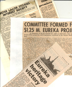 Federation University Historical Collection
Book - Newspaper clippings, Eureka Stockade Newspaper Clippings, 1923-2015
The Eureka Stockade was fought on the Eureka Lead, Ballarat East on 03 December 1854. Keith Rash was a signwriter who learnt his trade at the Ballarat School of Mines. He was very interested in local history and wrote articles for the local newspapers. The clippings on Eureka would have been used to inform his articles, and research on the site of the Eureka Stockade. Ken Clements was former Academic Registrar at Ballarat College of Advanced Education (now University of Ballarat). He was a committee member of the Eureka Stockade Memorial Park Committee for a number of years. Dr Dorothy Wickham has researched Eureka over a number of decades, and has published a number of titles on the topic. Clare Gervasoni has researched Eureka over a number of decades, and has published a number of titles on the topic, including coordination of www.Eurekapedia.org for Ballarat Reform League Inc. Three white A4 folders of newspaper clippings dating from 1923 to 2012. The clippings are in chronological order. The clippings were collected by Keith Rash, and were later supplemented by clippings collected by Ken Clements. Further clippings collected by Dorothy Wickham, mainly around the 1990s were inserted throughout the folders in chronological order, as well as later clippings by Clare Gervasoni .1) Folder One - Eureka Cuttings 1923 - 1984 * Courier 05/05/1923 - Eureka Progress Association (W. Groves, Stockader Phillips of Rocky Lead, Stockader Wilson, G. Lakeland, Eureka Hall.) * Courier 10.08.1931 - Banquet at Eureka - Progress Association's Annual Meeting (McGregor, Parsons, W.J. McAdam, 75th anniversary. Elsworth, Kent, Robert McGregor) *Courier 11/08/1932 - Eureka Reserve - Committee Annual Social. (E. Parsons, C.C. Phillips, D.C. McGrath, T.T. Hollway, Bolster, Mackenzie, Mares, Hendy) * Courier 07/07/1939 - Eureka Improvement Committee, Eureka Reserve * Courier 04/12/1950 - Australian Democracy Was Born at Eureka * Courier 04/09/1951 - Council Seeks Development of Eureka Land - potential housing Commission development on site of Last Chance Mine. (J. Welsh). * Ballarat Courier 12/1952 - Few Remembered Eureka Affair (98th anniversary, A.W. Nicholson, C.E. Brown, L. O'Brien, R. Joshua, Soldiers' Memorial Band) * Courier 07/12/1953 - Few Commemorated the Affair at Eureka - 99th anniversary at the Stockade reserve (F.J. Cutts, L. O'Brien, R. Joshua, Peter Lalor, C.E. Brown. * Courier 14/04/1954 - Eureka Centenary - meeting to determine form of commemoration. * Courier 15/04/1954 - Getting ready - Centenary celebrations (Picture of Diggers Memorial, F.J. Cutts, C. Mott). * Courier 15/04/1954 - Eureka Centenary Planned (F.J. Cutts, Geoffrey Searle, Edgar Bartrop, G. Swenson, B. Parsons, T.E. Carter, M. Collins, Mrs L.M. Quinlan, Grenville, Eureka Progress Association, Arthur Jones, E.J. Crimmins, Bernard D'Arcy, A.W. [Bert] Strange). * Guardian 25/11/1954 - Diary of a Eureka Stockader [signed RDW] (Bentley, Fletcher, McIntyre, Westerby, Ballarat Reform League, monster meeting, Bakery Hill, Charles Hotham) * Argus 04/12/1954 - Eureka Day Marred by Storm (image of Bert O'Toole in Red Coat uniform, Peter Lalor Statue, A.C. Pittard, F.J. Cutts, Bernard D'Arcy, L. Moyle, Catherine Smith, wounded, death, Eureka Celebrations, anniversary, John Cain *Age Literary Supplement, 04/12/1954 - The motives that prompted the tragic Eureka rising . (image of Charles Hotham, government troops attack, Eureka Stockade Monument) 1851 discovery of gold in Victoria, centenary of Eureka Stockade, author MM, Governor Latrobe, law abiding nature of most miners, most miners were British but other nationalities represented, miners former occupations were varied, many did not "strike it rich", by 1853 the earnings of most diggers had fallen very low, 30/- licence fee, digger hunts, cries of "Joe" or "The Traps", 5 pound fine or 6 month imprisonment for not carrying Licence, La Trobe had hired ex-convicts as police, Governor Charles Hotham 1854, Bentlys Hotel, Commissioner Rede, miners leader Peter Lalor, Carboni Raffaello, Press warning by "Age", Ballarat Reform League, November 29 diggers meeting, licences burned, November 30 licence hunt, new flag and Southern Cross oath, the Stockade, revolution ?, Stockade Garrison, December 3 1854, the battle, 125 prisoners, 13 charged with high treason, all prisoners acquitted, Lalor and Vern into hiding, 'democratic revolution' or 'undisguised rebellion' ? , Miner's Right, Chartist ideas involved, Lalor became a member of Victorian parliament, Eureka monument inscription, little revolutionary significance. * The Argus 06/12/1954 - 100th Eureka Day ( [ Images - bearded miners, Bert O'Toole, simulated battle, red coats] battle tableau, Centenary celebrations. Mr Cain Premier, Spirit of Eureka). * Ballarat Courier 22/04/1961 Attack on the Paint ( [Image - Eureka Monument Guns] vandals). * Ballarat Courier 13/09/1962 - Little-Known Aspects of Eureka Affair (E.J. Crimmins and the 109th Eureka Anniversary); Eureka Drilling (Photo of M. Milligan drilling for water for the Eureka Pool) * Ballarat Courier 10/12/1963 - Eureka Relics in Public Display (Trev Negri), Little-known aspects of the Eureka affair (E J Crimmins, 13 State prisoners, Creswick men, M Greville), Eureka Request (Apex explanatory notice). * Ballarat Courier 12/05/1964 - Plaque to tell Eureka Story (Apex donation on monument). * Ballarat Courier 09/06/1964 - Permission is sought (re Eureka Reserve small Hall). * Ballarat Courier 28/08/ 1964 - Eureka should be much better attraction (Mayor Cr Webb, Rotary). * No Chlorination at Stockade Pool 24/08/1964 (A Jones secretary) * Ballarat Courier 10/10/1964 - Assurance given on Eureka Swimming Pool (Murray Byrne MLC, Bill Stephen MLA, pool plans [Images - Photo of Jones, Stephen Byrne - diagram of Eureka reserve swimming pools, caravan park, monument area] ) * Ballarat Courier 23/06/1964 - Pool plans ready for tenders MLA (Black Hill) * Ballarat Courier 26/11/1966 - Eureka: Was that clash in 1854 inevitable ? ([Image - Monument, Peter Lalor statue], by J J Sheehan, foreigners, Chartists, poorly armed. * 03/12/1966 Part 2 - Eureka: No plan by the Diggers to Attack, by j j Sheehan ([Images - Eureka collection, W C Colbourne and G Brookes with old rifle] Corrupt, Instructed, Withers' view, The last hunt, Police spies). * Ballarat Courier 19/12/1968 - Eureka commemoration definite next year,1854 - (Connolly Association, 3 December, 'Finest thing in Australasian history', few attending, L O'Brien, public apathy, A Williams, successful 1954 centenary, W. Roff, Eureka Progress Association) * 23/11/67 - Eureka and Miners' rights (G P Ryan letter, no representation, excessive licence system, offensive administration.brutality, Gov Hotham, barricade on Eureka lead, Miners' Rights replaced Licences but now worthless, mining monopolies, democracy). * Eureka Flag Ceremony (L O'Brien, false report, revive annual Eureka service). * Ballarat Courier 12/05/1867 Questions of Eureka (W Thompson letter, why military names on monument ? Why mount irrelevant cannons on monument ? Where is the flag ?). Lalor's refuge (between Bungaree and Bullarook ?, Fr t Linane ). Building linked with Ballarat (at French end of Collins Street Melbourne, Sir Robert Nickle, relief march to Ballarat, historian E Moorhead, 40th regiment link ). * Ballarat Courier 08/01/1968 - Too little history at Eureka says Visitor (Image - Eureka monument, Mrs L Riley, frequent complaint, B McOrist, proposed Stockade model). * Ballarat Courier c 1968 - Gallery Eureka flag may be the original (Cr W Roff, at Ballarat Art Gallery, fraud ?, matching pieces). * Ballarat Courier 11/04/1968 Pool of reflection ([Image - Eureka pool and willows], near full again). * Ballarat Courier 20/08/1968 - Eureka Reserve (Rotary Clubs' proposed project). *Ballarat Courier 05/10/1968 - Picturesque Willows ([Image- willows in good condition at Eureka Stockade]). * Ballarat Courier, November 1968 - Eureka Ceremony will be Revived (Eureka Progress Association to revive Eureka Commemoration at the site, Connolly Association Australia, J. Garvey, A. Jones) [Photo of L. O'Brien, A, Jones, R.A. Mitchell, Jim Styker and Alan Mills *Ballarat Courier 15/11/1968 - Walkathon for Stockade Diorama (planned life-size Diorama at Stockade depicting the Eureka riot, Rotary Cup walkathon fundraiser. *Ballarat Courier 26/11/1968 - Discussing plans ([Image - Les O'Brien, Arthur Jones, Alan Mills et al], memorial service Sunday). * Ballarat Courier 26/11/1968 - Eureka ceremony will be revived (four year lapse, Connolly Association, Eureka Progress Association) * Ballarat Courier 02/12/1968 - 500 attend Eureka ceremony (114th commemoration, on island in Lake, Mayor Cr M J Brown, speaker Mr Dudley Erwin MLA, significance to Australia, Connolly Association morning ceremony, Bernie Nolan, W Hartley). * Courier 1969 - Letters to the editor - Peter Lalor's Grave, Losing Places of Beauty loss of verandahs, Eureka Stockade Caravan Park, Eureka Swimming Pool), Ireland's Dilemma (Catholic Church), Small Group in "Affair" (F.R. Muller) * Courier 22/04/1969 - $7000 grant for Eureka Diorama (Sir Henry Bolte approves grant, $2 for $1, Rotary walkathon basis, City Council interest, Diorama details, information about Eureka for public, Eureka Park Sovereign Hill and Montrose cottage combination). * Courier 21/08/1969 - Mayor turns sod at Diorama site ([Image- Mayor Cr M J Brown et al], life size representation of stockade scene, Mr W F Stephen MLA). * Courier 06/12/1969 - The 'affair at Eureka' ([Image- Diorama] Few remembered anniversary of bid for democratic Government in 1850s, Mayor Cr Alec Mills, Murray Byrne, Colonial secretary J Foster resignation, reforms, hostility, unpopular, end of era). * Courier mixed 1969 - City link with Eureka Stockade threatened, - Eureka signposts [Diggers Memorial, Soldiers Memorial], - Eureka Anniversary - Souvenir of Eureka (William Cowland's pistol). * Courier :/05/1970 - Fascinated ([Image- children at near completed Diorama]). * Courier 10/08/1970 - Mayor opens Eureka Diorama ([Image- Diorama scene of 3 December 1854 battle], Mayor Cr A E Mills, Rotarians, Eric Pearce voice tape recording). * Courier 08/08/1970 - Eureka Diorama should be Popular-Rotarian ([Image- Diorama shed], City's new drawcard, Diorama Opening para and advert). * Courier 12/09/1970 - The Quick change Eureka Stockade ([Image- Eureka Stockade Hotel], was Australia Felix Hotel, Mr Kevin Worthington). * Courier 22/09/1970 - Missing golden opportunities (message unheeded, American tourists misled, bewildered tourists). * Courier 20/10/1970 - Ballarat's monument to vandalism ? (Ballarat, Wendouree and South Rotary clubs' pride: Eureka Diorama, joy and heartaches, vandalism damage, thoughtless and vicious). * Courier 20/10/1970 - Marked for demolition ([Image- Ballarat east railyard] troops path to Eureka stockade). * Courier 20/10/1970 - Diorama sound system target for vandals ([Image- Jack Redman removing foreign material from diorama starting mechanism). * Courier 03/11/1970 - Record Good but Facts are Wrong ([Image- depiction of Eureka scene], article by Paul Hughes, RCA LP record based on musical play re Eureka Stockade, errors) * Courier 11/03/1970 - Diorama for Eureka Stockade ([Images- view of park, view of diorama]). * Courier 4/12/1970 - Anniversary of Eureka uprising ([Images- Southern Cross flag over Montrose cottage, R Fenton and V Demedeze], 107th anniversary, Scouts Eureka re-enactment, Diggers didn't mind delay). * Courier 16/04/1971 - Lake disappearing ([Image- Lake Elsworth being filled], Olympic standard pool planned for same site). * Courier 31/07/1971 - Birthplace of Peter Lalor ([Image- 211 year old Lalor home in Ireland], Eureka Stockade (park) name change to Eureka Stockade Memorial Park (in Sept. 1972). * Courier 01/02/1971 Eureka Stockade Gardens - ([Images- Gardens near Caretakers Cottage, Miss J Hetherington and begonias in Eureka Stockade hothouse). * Courier 11/1971 - Eureka Grant (for toilet block in Eureka Caravan Park), Ancestor Died in Stockade Battle (William Clifton), $93,887 Tender for Eureka Pool) * Courier 10/12/1971 - Eureka FILM 'iMMORAL' ( Erwin's attack, DUDLEY ERWIN MP, suggested cuts). * Courier 21/02/1972 - It is not a subsidy (says Stockade Director, re film, Added bonus, also Descendant upset- letter from Peter A Lalor re film content). * Ballarat Courier 31/10/1973 - Eureka Stockade a National Shrine, (Editorial , Minister Grassby's support) - Eureka 'Shrine of our History', (Grassby's pledge). * Ballarat Courier 14/02/1973, - $1000 Grant for Eureka Flag (from State government to Ballarat Art Gallery, Bill Stephen MLA, Murray Byrne Minister for Tourism). * Ballarat Courier 26/05/1973, - Eureka Flag Restored (by Val D'Angri, Peter Lalor details, [Images- Val at work on flag, painting of 1854 Ballarat]). * Ballarat Courier 26/10/1973 - Taking another look at Eureka (Editorial, historical and social significance of Eureka Stockade, Neighbour attractions, Thinking BIG), and Editorial report, Put up the Stockade again - and a Monorail ? * Ballarat Courier 31/10/1973 - Eureka Stockade a National Shrine (Minister's support) * Ballarat Courier October 1973 - Eureka a 'Shrine of our History' (Grassby's pledge, Alex Barnett's plans for Eureka Stockade ). * Ballarat Courier 03/11/1973, - Build Eureka into a tourist drawcard ,(Challenge to Clubs. W H McGregor; Ceremony, Tram Link, the "Iceberg"). * Ballarat Courier 08/11/1973, - Grassby to get Eureka Plans - (from Alex Barnett). * Ballarat Courier 29/11/1973, - Memorial Plans with Town Hall (Architect plans also sent to Mr Grassby). * Ballarat Courier 13/11/1973, - Prime Minister will unveil Eureka Flag [Image - Erecting Flag frame at Ballarat Art gallery, Val D'Angri]. * Ballarat Courier 14/11/1973, - What plan for the Eureka memorial ? (Public entitled to know, National concept) and (Eureka Upgrading). * Ballarat Courier 24/11/1973, - Connolly Opposition to Eureka Proposals (Association protests about limited support for commemoration of Eureka) and (Gallery search for Lalor descendant). *Ballarat Courier 24/11/1973, - The Affair at Eureka (Part one by J J Sheehan) [Images -Jones' Circus tent, and Stockade location, also Peter Lalor photo, also artist's impression of the 13 men on trial]. Part 2 )3/11/1973 (Eureka Diorama) * Ballarat Courier 01/12/1973, - Grassby to see Eureka Plan on Site [Image- Architect's sketch of proposed $450,000 Museum building]. *Ballarat Courier 01/12/1973, - The Affair at Eureka (The fight for justice, concluding J J Sheehan series), [Images - painting of fight, and the supposed site of the Stockade]. * Ballarat Courier 02/12/1973, Victorian Treasures at Art Gallery (Eureka Flag and "Moonrise exhibition), [Image - J Nicholson cleaning 'Peter Lalor' portrait]. * Ballarat Courier 03/12/1973, - The Events Which led up to Eureka (Licence contentions,the perceived need for fortification around the workings at the Eureka lead, the death of James Scobie, the burning of Bentley's Hotel, the conviction of three miners on 20 November, arrival of armed soldiers at the Camp. Also Raffaello observations, and advert for public viewing of Eureka Flag. [Image - Diggers and Soldiers names on Eureka Monument]. * Ballarat Courier 03/12/1973, - The past celebrated but what of the future ? (119th anniversary of the Eureka Stockade uprising, but current politicians are under close scrutiny) * Ballarat Courier 03/12/1973, - Teacher-Politician is behind Eureka story (J J Sheehan profile). *Ballarat Courier 04/12/1973 - A Noteworthy Day in Ballarat - (Prime Minister Whitlam unveiled the famous Eureka Flag at the Art gallery). * Ballarat Courier 04/12/1973, - Newcomers told about migrants at Eureka (migrants from >20 countries, comradeship after battle and defeat, new nation in peace and tranquility. Minister for Immigration Mr Al Grassby at Sovereign Hill. Liberties. A Shrine. [Image- Al Grassby and newly arrived migrants at Sovereign Hill]. *Ballarat Courier 04/12/1973, - Grassby leads colorful Eureka commemoration (cheering school children, flag, wreath, World Fame for Eureka affair, boy's coach trip, two sides to Eureka battle.) [Image- Mr Grassby and group of children]. (National day proposed by Mr Grassby). * Ballarat Courier 04/12/1973, Eureka as National Monument (PM commends stockade plan, Mr Whitlam on Eureka commemoration day supports plans to make Eureka Stockade a national monument. Flag saved and restored, TV hitch. New Australian anthem needed to match the 'new nationalism'. [Image - Gough Whitlam and group at flag presentation and unfurling ceremony.] * Ballarat Courier 04/12/1973, - Eureka ! It's Digger Al (Al Grassby at 119th anniversary of the Eureka Stockade rebellion). [Images - scenes of Al Grassby at Sovereign Hill]. * Ballarat Courier 05/12/1973, - Talk, But No Cash: Stephen (Mr Bill Stephen MLA comments on visit by Whitlam and Grassby). - Eureka Flag Australia's most valuable relic: PM (Gough Whitlam report to Federal Parliament yesterday, Hospitality from Mr Dudley Erwin) * Ballarat Courier 10/12/1973, - Flag restorer stitched her way into history (Val D"Angri has stitched her way into Australian History as the person who restored the Eureka Flag. [Image - Mrs Val D'Angri, Eureka Flag needlewoman ]. * Ballarat Courier, 1974 - Location of the Eureka Stockade (Bert Strange), Misplaced Stockade (Maurice Calnin, T.C. Cleary, diary), Stockade Site (Bob O'Brien), Eureka Flag Stolen (John Shannon) *Ballarat Courier 6 May 1974, - Committee formed for $1.25 M. Eureka Project - ( a permanent memorial). *Ballarat Courier 6 May 1974, - Federal Govt Aid likely for Eureka (Federal Labor Government wants Eureka Stockade site to be a major tourist attraction, Eureka booklet proposed). *Ballarat Courier 10 May 1974, - Peter Lalor Stories Interest Society (Ballarat Historical Society seeks reports of Peter Lalor during escape after the Eureka affair). Also Eureka Shrine, The Eureka 'affair', Eureka film premier. * 29/07/1974 - Eureka Memorial Plans Need Full Support (Eureka Stockade Association) * Ballarat Courier 11/5/1974 and 6/6/1974 - Stockade Site (Rob O'Brien, Eureka Interesting Story * Ballarat Courier 30/01/1974 - Eureka Remembered in Italy (Al Grasby, Raffaello Carboni, Urbino); Eureka Memorial on Way (Eureka Stockade Association) {photo of Gordon Cornell, Alec Barnett, Bruce Bartrop] * Ballarat Courier, May 1974 and 11 May 1974 - Location of the Eureka Stockade (Bert Strange); Stockade Site (Bob O'Brien) * [Ballarat Courier?] 10/07/1979 - City's Oldest Memorial is Over Diggers' Graves. (An article on the grave over the diggers who were killed as a result of the Eureka Stockade battle which was erected on 22 March 1856. .2) Folder Two- Eureka Cuttings c1980-2004 Ballarat Courier ~9/1980, - First-hand account of hardship omitted (Frank Titan letter re Tom Evans' use of selected evidence in his proclamation that democracy was not born at Eureka Stockade. "Democracy was won at the Stockade on 3/12/1854. [Cartoon 'A beach view of the Eureka Flag debate']. Ballarat News ~1980, Names (Diggers & Troopers) of deceased on Eureka Stockade Monument. [Photo of white marble tablet] Ballarat Courier 4 July 1981, Eureka Papers Gift to City, Peter Lalor letters, Stephen Cumming diary. [Photo - Town Clerk Ian Smith, Cr Jessie Scott and donor Bruce Evans]. * The Sun Travel Supplement, 06 April 1984 - A Bloody Moment Re-visited by Alec Hepburn - (Diorama, Eureka Stockade Replica, Montrose Cottage) [Image of Gerard Rushforth to the reconstruction of the Eureka Stockade * Ballarat Courier, 10/04/1984 - Eureka Incident 'an uprising of the scum of goldfields. [photo of John Callinan with the Diggers Grave monument] * The Age, 06/05/1987 - Eureka! Man found whose father was there by John Lahey (Article on Terence Brady, who was a 4 month old baby at the Eureka Stockade battle. * Ballarat Courier 13 June 1984, 'Eureka Stockade'.....a Panning, (American critic J J O'Connor pans the Australian TV Mini-series. Book 2 - C1990-2004 * Ballarat Courier ~1990,- High-calibre Restoration, (World War I German Howitzer being restored after about 70 years exposure in the Eureka Stockade Memorial Park). [Photo of wheeled Gun, and article by author Peter Butters]. * Ballarat Courier, ~1990, A Changing Track to Eureka, a 'Room for a View' article by Alex Barnett OAM. (comment about the Stockade site and the tracks leading to it). [Photo of painting by Charles Doudiet depicting the diggers swearing allegiance to the southern Cross on 1 December 1854]. * Ballarat News 22 March 1990 - Eureka Troopers Slept Here (article on the Werribee Hunt Hotel, near the Ballarat Gold Course, where troopers slept and watered their horses on the way to Ballarat in 1854. [photograph of the hotel] * Ballarat Courier, 23 August 1991 - Eureka relics Return to Ballarat by Gemma Daley. Items acquired by Sovereign Hill - including a Ground plan of James Bentley's Eureka Hotel, autographed statement by Michael Carroll. (photograph of Peter Hiscock holding a set of percussion pistols, the Plan of the Eureka Hotel] * 30 November 1992 - Ballarat Courier 'Hayden Pays a Visit' by Julia Balderstone (Article on the visit of Governor-General Bill Hayden to Ballarat, the launch of Bob O'Brien's book 'Massacre at Eureka: The untold Story' ) [Photographs of Bill Hayden, Mayor James Coglan, Sovereign Hill, Bob O'Brien) * Ballarat Courier 03 December 1994 - Awareness grows of flag's meaning by Lorrie Brown (article on the Ballarat Trades Hall replica of the Eureka Flag. The replica flag was made by the then Trades Hall caretaker Tom Ellis. The replica flag was used in a Trades Hall march in 1945 and then disappeared until the mid 1980s (Image of David Miller nad Graeme Shearer in front of the flag.) Verso - Robert and Pamela Sublet and their link to the Eureka Stockade via their ancestor Charles Sublet de Bourgy and the site of the Eureka Stockade. * 04 May 1996 Ballarat Courier Saturday Magazine Extra 'Our Next Flag?' by Gabrielle Hodson (An article on the Australian Flag and the Eureka Flag with interview with Gayle Hart (Ballarat Fine Art Gallery) * Ballarat Courier, 15 February 1995 - 'Knockers' Harming the Story of Eureka - an opinion piece by Lewis L. Gay (descendant of William Gay) * Ballarat Courier, 10 July 1996 - Facts, not our bias, are Eureka's basis, an opinion piece by Tom Evans * Ballarat Courier 03 September 1996 - Tell Warts and All of Eureka by Weston Bate (image of Weston Bate) * The Age, 21 December 1996 - Mining a rich vein of passion by Mary Ryllis Clark (Eureka overview with information on Charles Doudiet). * Ballarat Courier, 07 July 1997 - Eureka Flag Row (Sale by auction of Eureka Flag piece held by Lex McClintock - associated with Communist Party and Evelyn Shaw) [Photo of Anne Beggs Sunter beside the Eureka Flag] * Ballarat Courier, 02 August 1997; images of the Eureka sail on the Eureka centre from different locations. * Ballarat Courier 23 October 1997, Eureka Stockade Centre Agreement is signed, (Sovereign Hill to manage new Eureka Centre). [p 1 Photo Doug Sarah, Janet Dore, James Coghlan, Peter Tobin, and Peter Hiscock at table; p 2 photo of new Eureka Centre and reference to 21 year management agreement between City of Ballarat and Sovereign Hill Museums Association. * Ballarat Courier 23 October 1997, 'A Handsome Addition to our Heritage Assets' [Plan of Bentley's Eureka Hotel ason 17 October 1854 it was when it burned ] * Ballarat Courier 03 November 1997 - Different Eureka Flag. Letter to the editor from A.D. Glasson. * * Ballarat Courier 23 October 1997, 'Did Eureka Claim the Drummer Boy' Dorothy Wickham prooves the Drummer Boy of the 12 Regiment. John Egan. did not die in the events leading to the Eureka Stockade. * Ballarat Courier ~1998, - Alex and Audrey thanked, (Total of 90 years work for Eureka Stockade Memorial Park Committee recognised), [Photo of Gordon Taite, Alex Barnett and John Barnes. * Ballarat Couruer, 04 February 1998 - Exciting Eureka Flag Find in UK by Stuart Howie. (Eureka Flag held in the Suffold Military Museum) [Jan Penney holds with a Eureka centre logo.] * Ballarat Courier 23 February 1998, Eureka Centre almost ready, (Workers adding finishing touches, description of $4m Centre by Manager Jan Penney). [Photo of new Eureka Centre, Mothers Art figures, Jan Penney, stage coach, Trooper John King]. [Photo Dorothy Wickham an d Governement Camp] * Ballarat Courier 23 February 1998, Forging links with Irish (Article by Leanne Keem on visitors from County Wicklow, 1798 Rebellion, convicts, Wicklow Historic Gaol.) [Photograph at Sovereign Hill of Joan Kavanagh, Pat Vance, Balise Treacy) * Ballarat Courier 28 March 1998, On to Camp Street, Premier urges at Eureka opening, (Comments by Mr Kennett about Eureka and the Ballarat community). [Various photos and paras about participants and about the Centre]. * Ballarat Courier 28 March 1998, EUREKA CENTRE SETS FULL SAIL, (celebration of launch of new centre by Premier Jeff Kennett). [Cartoon re Red Carpet and flag pieces]. * Ballarat Courier 17 November 1998, National Eureka Day idea 'could boost city' (Mayor Judy Verlin) * Ballarat Courier 28 November 1998, - MP backs Eureka Sunday, (Michael Ronaldson supports idea of a national Eureka Sunday to recognise Eureka's significance). [Photo of Michael Ronaldson MHR]. * Ballarat Courier 1/12/1998, - Red Eureka flag symbolic for anniversary, (red spotlight on giant Eureka flag model above the new Eureka Centre for 144th anniversary week, and outline of displays in Centre by manager Dr Jan Penny). [Photos - red 'Eureka Flag' on new Stockade Centre, and cartoon re 'tomato sauce']. * Ballarat Courier 2/12/1998, - Eureka enthusiast hopes for national day of celebration, (Jack Harvey expresses his hope that 'Eureka Day' might replace 'Australia Day' as our national day for celebration of anniversary of the formation of Australia, especially if Australia becomes a republic. History of the Dawn Walk in a list). [Cartoon re Eureka Walk Backpacker]. * The News 2/12/1998 - Lanterns to Light Path on Eureka Walk by Toni Lea-Howie - Dawn walk, lanterns, Jack Harvey, * Ballarat Courier 3/12/1998,- Marching the light fantastic, (Lighting the way, lanterns being prepared at Mining Exchange under direction of maker Graeme Dunstan in readiness for Sunday dawn walk, and other details of the Sunday program). [Photo of Belinda Dyer and Michael McTigue with several lanterns and a Eureka flag in the background]. * Ballarat Courier 4/12/1898, - Old trash reveals gold rush lifestyle , (display of artefacts dug from ground before new Eureka Centre built, Dr Jan Penny spoke, Minister Rob Maclellan launched the display, Cr James Coghlan announced the formation of the Eureka Stockaders support group with Peter Tobin and Alex Barnett as Life Members, article by Diane Squires. [Photo of Robert Maclellan and Gael Shannon with archaeological artefacts]. * Ballarat Courier 04/12/1998 'Many Behind New Eureka Centre' by Paul Murphy. (An article about the origins of the Eureka Stockade centre through the eyes of Paul Murphy, Executive Office of Eureka's Children. It includes the 1988 Bicentennial Eureka celebrations, Eureka Commemorative Society, Peter Tobin, Eureka Stockade Memorial Trust) Also inclides a letter from Bob O'Biren on the Origins of the Eureka Flag. * Ballarat Courier 5/12/1998, - Eureka walk revisits past , (Lantern bearers in a dawn walk will follow path taken in 1854 by troops as they marched to the Eureka Stockade, article by Rohan Wade). [Photo of Wayne Parker and Peter Freund discussing the internet recording of the dawn walk]. * Ballarat News 06/12/1995 - Lest we forget the fallen at Eureka by Peter Butters (William Westgarth, Captain Wise, Charles Rich, coffins, Bakery Hill meeting, Eureka monument, James Scobie, George Scobie. * Ballarat Courier 7/12/1998, - DAWN HOMAGE TO EUREKA HEROES, (300 take part in Dawn Walk, organiser Margaret Rich describes the community response and participation as fabulous and thanked Ballarat Fine Art Gallery for underwriting this years event). [Photo of dawn walkers on way to Eureka Stockade on Sunday, and photo of walk Leader Jack Harvey]. * Ballarat Courier 7/12/1998, - Walk sees the dawn of a national day, (3.30am marshalling of dawn walkers at Mining Exchange building by leader Jack Harvey and lantern maker Graeme Dunstan was spectacular; at the Eureka monument Don Chip addressed the large gathering on the significance of Eureka, Big turnout draws praise from Dore, Gallery echoes stirring oath).[Photo of Jack Harvey, Janet Dore, and Margaret Rich, Photo of Evelyn Healy, Cartoon re Ho Ho Ho ]. * Ballarat Courier 7/12/1998, - Miners were fighting for a fair go : Chipp, (Stirring Eureka address by Democrats founder Don Chipp,University lecturer Jack Harvey shares his passion, Walk invite for Jeff Kennett). [Photos of Don Chipp, Phil Cleary,Tobi and Chris Kelly, and other dawn walkers]. * Ballarat Courier 8/12/1998, - Eureka day just not for historians , (Editorial re inaugural National Eureka Sunday with comments about the program and the participation of many who are not historians). * Ballarat Courier 8/12/1998, - 'Children' threaten Eureka walk, (Paul Murphy declares that 'Eureka's Children' group would disrupt next years National Eureka Day Dawn Walk unless group criticisms of the 1998 program are heeded and changes made. Janet Dore states that Council noted advice from several community groups in setting the program). [Photo of 1998 dawn walkers]. * Ballarat Courier 9/12/1998, - Donors vital part of Eureka centre, (Dr Jan Penney, Manager of the Eureka Centre, praised donors towards cost of the Centre and the exhibits in contradiction of an article by Paul Murphy of 'Eureka's Children' group). [Photo of Dr Jan Penney]. * Ballarat Courier 9/12/1998, - Dawn Walk will continue to grow , (Editorial comment on Paul Murphy's criticism of the recent commemoration of Eureka Day including the date, the march, and use of the southern cross). * Ballarat Courier 9/12/1998, - People and Places: Eureka Dawn Walk [photographs of Dawn Walk participants, including Don Chipp and Jack Harvery * Ballarat Courier 17/12/1998, - Spirit of cooperation set up Eureka centre , (City of Ballarat chief executive officer Janet Dore gives the council's point of view on the story behind the Eureka Stockade centre, perhaps prompted by Paul Murphy's recent statements, : many individuals have participated cooperatively, the state and federal governments have cooperated as have the Eureka Stockade Memorial Trust Committee, the Eureka Project Special Committee, the Centre Historic Contents sub-committee, the Eureka's Children group, community donors, the Eureka Stockade Advisory Committee, and the Sovereign Hill Museums Association). [Photos of the Eureka Stockade centre, and Janet Dore]. * Ballarat Courier 13/2/1999, - Leaky Eureka Centre leaves visitors out in cold, (Leaky ceiling leads to closure of Eureka Stockade Centre at about 2.30pm yesterday after extremely high rainfall despite much work done on earthen wall after earlier trouble). [Photo of Dr Jan Penny in the Centre Cafe and a bucket catching water]. * Melbourne Weekly, 1-7 March 1999 - Ballarat's Eureka Stockade (overview of the Eureka Stockade centre, archaeology) [Photo of Eureka sail on the Eureka Stockade centre] * Sunday Age 7/11/1999, - Maintaining the Eureka rage, (Paul Heinrichs meets the heirs of Australia's first republicans; discussion of republican pressures and other community views in relation to the Eureka rebellion, assuming Paul H is the author of the article). [Photo of Veterans of the Eureka rebellion at a reunion in 1904 and photo of 'Eureka's Children' Robert Dublet. John Ireland, Christine Gillespie and Paul Murphy unfurling a Eureka flag at the Old Melbourne Gaol - cross purposes ?] * Family Salutes a Link with History by Tony Wright (John King descendants) [Owen and John King hold a Eureka Flag] * Eureka Children Claim Historic Flag Was Stolen by Rohan Wade (contends Eureka Flag was unlawfully removed from the Eureka Stockade. * The Making of a Eureka Myth by Tom Evans (too much emphasis on the role of Eureka in the move to Australian Independence) * Ballarat Courier, 06/12/1999 - Brave Terrier's Statue Unveiled by Peter Litras (Article about the statue to the Pikeman's Dog which was unveiled at the Eureka Stockade Centre by Victorian Premier, Steve Bracks. * Ballarat Courier 03/12/1999 - Streets to Light Up on Eureka Sunday (Article on the Eureka Dawn Walk and lanterns. The walk was attended by Irish Ambassador Richard O'Brien , and Federal Senator for Victoria Tsebin Tchen). * Ballarat Courier 1/2/2000, - Eureka myths, (Tom Evans, historian and former member of parliament, writes we should be wary of large claims about the significance of Eureka in the development of the Australian spirit). [Photo of Eureka/an artists impression, and photo of Historian Tom Evans]. * Ballarat Courier ~March 2000, - Monument to Eureka, (Peter Butters discusses the Eureka monument in relation to ecology of the Stockade reserve with particular reference to tree removal). [Photo of early view of Eureka monument]. * Ballarat courier 30 April 2000, - Eureka Stockade work a family tradition (Alex Barnett comments on his recent award of an OAM), [photo of Alex Barnett and new Eureka Centre]. * Ballarat Courier 13 May 2000, - In Retrospect (para 3 re 'Mrs Anne Franks'). * Balalrat Courier 18/07/2000 - Eureka Group Wants Headstone Removed by Lyndal Reading (Article about the headstone to the drummer boy, John Egan, erected in the Ballaarat Old Cemetery in 1988. Dorothy Wickham's research discovered that the drummer boy did not die as the result of a pre-Eureka inceident, therefore Eureka's Children called for the gravestone to be removed.) [Photo of Paul Murphy and the headstone] * Ballarat Courier 29 November 2000, - Eureka Guide to December 3, 1854 (four pages of articles, adverts and photos including authors Angela Carey, Joy King, Tom Evans, Anne Beggs Sunter, Bob O'Brien, Steve Bracks, Peter Kennedy and Weston Bate). * Ballarat Courier 12 December 2000, - Union should bow out of Eureka Debate (Tom Evans letter). * Ballarat Courier ~2002, - Eureka Stockade a Family Tradition (Alex Barnett receives OAM), [Photo of Alex and new Eureka Centre]. * Ballarat Courier, 30 October 2002 - Democracy's debt to goldfields pioneer by Paul Williams [photo of J.B. Humffray and a number of people around Humffray's grave] * Ballarat Courier, 03 December 2002 - Unfit to Fly by Mariza Fiamengo - Failed attempts to fly the Eureka Flag at Parliament House, Canberra) *Ballarat Courier 10 December 2002 – Charter Campaign rewrites history, by Tom Evans, including an image from Doudiet. * Ballarat Courier 31 July 2002, - No Right From Eureka (Mjner's Right and Australian Democracy not 'born at Eureka'), letter by Tom Evans. * Ballarat Courier, 07 September 2002 - Statue to honour Italian Eureka democracy fighter by Julia Hodges. (Preliminary sketches for a statue of Raffaello Carboni by Gary Anderson) [Preliminary sketch for statue] * Ballarat Courier 10 December 2002, - Charter Campaign Rewrites History (Eureka did not gain democracy for Victoria), article by Tom Evans, [Photo of C.Doudiet's sketch of soldiers at Eureka Stockade.] * Herald Sun, 04 April 2003 - Rebels with a cause * Ballarat Courier 5 August 2003, - Bloodline claim to Eureka irrelevant (Denial of claim by 'Eureka Children' that they know best about interpretation of Eureka), article by Dr Paul Laffey. * Ballarat Courier 21 August 2003, - Information session on Eureka Gardens (Notice of public meeting at Eureka Centre), * Ballarat Courier 24 October 2003, - Which is the true Eureka version ? (argument that there is only one true Eureka story), [letter by Tom Evans]. * Ballarat Courier 28 October 2003, - Many threads in a complex fabric (criticism of Tom Evans' case for the one true version of Eureka), letter by Ken Clements. * Ballarat Courier, 2004 - Australia Port Stamp Issue: Eureka 'spirit' honoured - stamps issued for 150th anniversary * Ballarat Courier, 2004 - Think About the Ideals by Dot Wickham (Ballarat reform League, Chartism (photo of military reenactors in the Ballaarat Old Cemetery) * Ballarat Courier, 2004 - The Flames that Lit Eureka by Peter Butters (burning of the Eureka Hotel) * Ballarat Courier 27 January 2004, - Democracy not born at Eureka (Claim that England granted 'Australian' colonies democracy two years before the Eureka battle), letter by Tom Evans. * Ballarat Courier 4 February 2004, - Forget Eureka, what about Westminster ? (Denial that Eureka was the birthplace of Australian democracy), letter by Tom Jobling, [plus Eureka flag cartoon and sundry other letters]. * Ballarat Courier 23 February 2004, - Eureka coin makes its mark (Minting of $1 coins to mark 150th anniversary of Eureka Stockade), report by Katie Maheras, [Photo of coin]. * Ballarat Courier 2004, -Eureka is for one and all (Eureka provides inspiration for many different ideologies but is not owned by any of them), Senator John Faulkner expresses his view about Eureka, [photo of new Eureka centre during recent dawn walk]. * Ballarat Courier ~2004, - Eureka : from the horse's mouth (An account by W Bourke of the Eureka fight as recorded in the Courier of 2 December 1904), one article in a series by Dot Wickham, [photo of Eureka veterans at 1904 jubilee celebrations, and photo of sketch of Eureka site]. * Eureka! The Past Gets a New Image with a Telling Makeover (an article by David Rood on historian Clare Wright's postdoctoral thesis 'Eureka's Women: An intimate History of Sex, Class and Culture on the Victorian Goldfields'. * The Sunday Age 31 October 2004 'Eureka: A job worth doing weld' (An article by Claire Miller on the 150th anniversary sculpture by Anton Hasell in the Eureka Stockade Gardens) * The Age 23 October 2004, - The Eureka Myth (An article by James Button discussing the meaning of the gold-rush uprising), [photos of tattered Eureka flag, impression of crowd hailing defendant after treason acquittal, and Peter Lalor actor; and copy of Mark Twain's famous 1890s quote re Eureka]. *`Ballarat Courier 27 October 2004, - Eureka flag to fly during historic journey to ice continent ('Ice Maidens' plan trek to South Pole), [Photo of 'Ice Maidens' and Minister Mary Delahunty, and modern version of Eureka flag]. * Ballarat Courier 1 November 2004, - Eureka 150th Anniversary Conference Dinner (Guest Speaker Gough Whitlam at University of Ballarat on 26 November), [Images of version of Eureka flag, and logos of Victoria, Eureka Spirit 150, City of Ballarat, and University of Ballarat]. * Ballarat Courier 5 November 2004, - Sculpture evokes life at Eureka (Interpretive sculpture titled 'Eureka Circle' by Dr Anton Hasell is being erected in Eureka Gardens), [Photo of Dr Hasell and image of the sculpture). * Ballarat Courier 5 November 2004, Plenty of stitches in time help re-create the history of Eureka (Eureka Women's Sewing Circle making banners based on the Eureka flag, report by Karen McCann), [Photo of Maisie Spry, Nancy Taite, Shirlie Jones, Thelma Lyle, Heather Caddy and a banner; and a photo of Marion Macleod at work]. * Ballarat Courier 6 November 2004, - A rich vein of golden history (An account by Dot Wickham about the history of the Eureka Lead; another in 'The Rest is History' series ), [Photo of Peter Butters, Eric Andrews, Dot Wickham and Tom Evans at old Eureka Lead; and photo of author Dot Wickham]. * Ballarat Courier 11 November 2004, - Historic miners' charter honoured in parliament (Copy of Reform League Charter to be presented to State Parliament and Professor Weston Bate will unveil a plaque at Bakery Hill commemorating the Ballarat Reform League; report by Jason Shields). * Ballarat Courier 11 November 2004, - Our 'priceless' Eureka flag (Article by Professor Garry Carnegien re estimates of monetary value of the flag), [image of tattered Eureka flag]. * Ballarat Courier 11 November 2004, - Eureka 150 (Feature coming in The Courier on 24 November), [Images of City of Ballarat and The Courier logos]. * Ballarat Courier 12 November 2004, - Eureka rebellion all about justice (Letter by Des Williams criticising Tom Evans' altered quotations, and stressing the injustices that existed before Eureka and that the miners charged over the affair were found to be not guilty). * Ballarat Courier 12 November 2014, - Eureka retains a special place in modern Victoria (Editorial comments on the high interest in the coming 150th anniversary of Eureka and lists some of the commemorative events planned). * Ballarat Courier 12 November 2004, - Charter vital to history : Bracks (Article by Jason Shields asserting that the Ballarat Reform League Charter is a landmark document in the history of our nation, quoting Steve Bracks, David Vendy and others) [Photo of Mayor David Vendy and L.A. Speaker Judy Maddigan; photo of replica Eureka flag flying over Parliament House; photo of Weston Bate and John Semmens unveiling Reform League plaque; copy of 'Call for freedom' from 1854 Ballarat Times; and advert for 'the scenes of Eureka' to be in the courier on 24 November]. * Ballarat Courier 13 November 2004, - Wanted: people to fly flags (Flag-bearers Needed for Parade of Nations as part of Eureka 150 celebrations). * Ballarat Courier 16 November 2004, - Latham to visit Eureka 150, while PM says no (Federal government appears to be snubbing Eureka’s significance, and Anarchists Demand an an apology for the Eureka ‘massacre’; article by Michael Ruffles) [Image of replica Eureka flag to be raised at Bakery Hill for the Monster Meeting simulation]. * Ballarat Courier 16 November 2004, - Democracy on display (Article by Eugene Kneebone re University of Ballarat Conference on democracy as part of Eureka 150 celebrations) [Image of Conference guests Weston Bate and Gough Whitlam]. * Ballarat Courier 20 November 2004, - But wait there’s more (Article by Peter Dwyer in ‘The State We’re In’ series, great Ballarat Events with another coming soon in the Eureka 150 celebrations) [Image of tattered Eureka flag]. * Ballarat Courier 20 November 2004, - Broadcast for Eureka (Ballarat Amateur Radio Group to broadcast worldwide carefully researched stories of Eureka from 27 November to 5 December) [Image of advert ‘The Stories of Eureka’]. * Ballarat Courier 20 November 2004, - PM sends Eureka message (A report by Karen McCann outlining John Howard’s view that Eureka was central to the development of the nation as an independent democratic country) [Image of PM John Howard]. * Ballarat Courier 22 November 2004, - Conference boost. under page heading ‘The Stories of Eureka 150, November 24 (Report by Michael Ruffles that Richard Franklin, Martin Kingham and Susan Mitchell would also speak at the University Democracy Conference, that Geoff Howard had presented a Eureka flag to Canadian Lead Primary School and spoken to the students about the significance of Eureka, that about 600 aborigines were living in the Ballarat area 50 years before 1854, and that a group of about 40 people would walk from Bendigo to Ballarat along the Great Dividing Trail arriving at the Eureka Reserve on 5 December) [Images of Martin Kingham, Susan Mitchell, Jose Ramos-Horta and Marjorie Mowlam]. * Ballarat Courier 23 November 2004, - CELEBRATION TOURISM BOOM (Front page article by Catherine Best, Massive influx expected for Eureka 150 commemoration, comments on various aspects of the program) [Image of Kim Rowe at Ballarat Visitor Information Centre]. * Ballarat Courier 23 November 2004, - Eureka 159 (Article by Catherine Best, Alcohol ban at major events, Sovereign Hill special show of ‘Blood on the Southern Cross’ sold-out; and report by Simon Gladman about addition of colour to activities by 10 volunteers sewing 50 decorative banners) [Cartoon re troops demanding their rum ration, Images of Marion MacLeod and Shirley Jones working on banners]. * Ballarat Courier 23 November 2004, - Show to go north following success, under page heading ‘Eureka 150’ (Article by Karen McCann re musical production titled ‘Eureka’, section re Sebastopol College flying Eureka flag proudly, and editorial comment about Courier publication ‘Eureka 150’ including contributions by Dot Wickham, Anne Beggs Sunter and Weston Bate) [Cartoon re Sydney understanding of Eureka, Images of Peter Dwyer, David Ellery and Ron Egeberg with a copy of the Eureka 150 publication, and images of Catherine King raising a flag at Sebastopol College with student Dellaram Jamli watching]. * Ballarat Courier 24 November 2004 - Eureka 150 Inside Today (page 1 heading advertising enclosed publication). * Ballarat Courier 24 November 2004 – Eureka 150 (Public invited to open forum, an article by Catherine best; Memorabilia goes on display, items from 125th anniversary display; Meeting to mark spirit of ‘fair go’, at Maritime Union meeting in Melbourne on 1 December; and Author shares insight, John Molony spoke at ACUB on 22 November), [Image of Pearl May, Bruce Bartrop, Doug Sarah, and Peter Davies with Eureka memorabilia; Listing of the 150th celebrations Program]. * Ballarat Courier 24 November 2004 – Let us simply enjoy Eureka (Letter by Allistair McCoy re cost of Eureka celebrations and government attitude to the Eureka affair). * Ballarat Courier 25 November 2004 – Eureka 150 (Delegates gather to discuss democracy, article by Catherine Best; Eureka history drama display in exhibition at Ballarat fine art gallery, article by Michael Ruffles; Sovereign Hill prepares for a rush of visitors, article by Michael Ruffles including comments by Jeremy Johnson), [Image of Gordon Morrison preparing the Eureka exhibition; listing of Eureka 150 Program]. * Ballarat Courier 25 November 2004 – Eureka 150 IT’S HERE (Page 1 article by Michael Ruffles re the first of eleven days of celebration) [Image of Jeroen Boersma, Peter Bray, and Chris Zakynthinos celebrating Sovereign Hill’s recent Tourism awards success]. * Ballarat Courier 25 November 2004 – Eureka 150, Spirit lives on:unions (Article by Michael Ruffles outlining union involvement in the celebrations) [Image of Brian Boyd and Graeme Shearer at Ballarat Trades Hall]. * Ballarat Courier 25 November 2004 – Personal feelings over proven facts (Letter by Tom Evans re Eureka rebels’ plans to plunder and destroy Ballarat after annihilating the Government camp). * Ballarat Courier 26 November 2004 – Latham Fires Up Launch (Eureka 150 conference underway in report by Catherine Best; On track for name change in report by Karen McCann, Steve Bracks supported a name change for the Ballarat train line to Eureka train line) [Image of Mark Latham and simulated flag on Eureka Centre]. * Ballarat Courier 26 November 2004 – Eureka 150 page 7 reports by Michael Ruffles (Italians honoured, concert to celebrate contribution of Italians to life on the goldfields 150 years ago; Campaigning to ditch our colony status by Peter Consandine through speaking about Eureka from a Republican perspective; Putting the Redcoat perspective by Lt Col Neil Smith) [Image of Peter Consandine]. * Ballarat Courier 26 November 2004 – Eureka 150 (Reports by Catherine Best, Alcohol ban dumped after Council plan defeated; Sailors to march in Ballarat from frigate HMAS Ballarat; Pupils in own dawn walk at Grainery Lane Theatre; Festivities move into top gear with official opening and start of formal program; MP fires up launch from page 1) [Image of six Wendouree Primary School pupils rehearsing Dawn Walk re-enactment; listing of remaining Program]. *Ballarat Courier 27 November 2004 – Eureka 150 (Symbolic hand-over, report of symbolic replicas of ‘Miner’s rights’; Call for Redcoats to return to UK, Paul Murphy claims that bodies of Redcoats killed at Eureka should be exhumed and sent to Britain but Ron Egeberg and Peter Lalor II disagree) and [Image of Theo Theophanous and Geoff Strang with commemorative Miners’ Right and image of Cr Stephen Jones with Redcoat models and Eureka Centre in background]. *Ballarat Courier 27 November 2004 – From many lands to Ballarat’s goldfields (Article by Dot Wickham in ‘The rest is History series’, various nationalities and major ideas featured in the Eureka story) and [Image of author Dot, and Image of Chinese at goldfields from Doudiet painting]. *Ballarat Courier 27 November 2004 – Eureka 150 (Diversity honoured, report by Emma-Kate Rickard of concert at Mining Exchange which celebrated the harmony between people of different nationalities at Eureka) and [Image of crowd watching ‘Wave the Flag’ concert at Mining exchange, and listing of Eureka 150 Program] *Ballarat Courier 27 November 2004 – Eureka 150 (Charter our ‘Declaration’, report by Catherine Best quoting remarks by Steve Bracks, Kerry Cox, Jose Ramos Horta, Gustav Nossal, and Alexandra Curtain at first day of Democracy conference) and [Images of these people]. *Ballarat Courier 29 November 2004 – Eureka 150 (‘Bakery Hill lights up once again’, commemorations of the 29 November 1854 Monster Meeting at Bakery Hill Ballarat and also at Federation Square Melbourne in article by Michael Ruffles, and report on ‘Musical tribute to Italians’, David Volk explained the tribute to the contribution made by Italians at Eureka and in the multicultural Ballarat), [Image of Hugh McKelvey, Alison Thompson, Peggy Ludt-Nash and Sarah Walters, and Italian flag]. *Ballarat Courier 29 November 2004,page 6 - Eureka 150 (‘Diverse views get a hearing’, report by Catherine Best of forum discussing claims of some groups that they are underrepresented in Australian democracy; ‘Call for more politics at school’ in report of talk by Adam Spencer; ‘For democracy, just listen; Dr Mowlam’, government must listen to the people, in report by Catherine Best), [Images of Tan Le, Adam Spencer, Marjorie Mowlam and remainder of Eureka 150 Program]. *Ballarat Courier 30 November 2004 – Eureka 150 (‘Monster of a day for city’, report by Catherine Best re yesterday’s re-enactment of the Monster Meeting, the first raising of the Eureka flag, the burning of licences, the march by 16 national flag-bearers, the swearing of the digger’s oath, the release of homing pigeons as a symbol of hope and peace; ‘Descendant travels from England for big occasion’, and report of participation in Eureka 150 by great-great-grandson of Alfred Madocks, Tony Fyson, from England), [Images of raising of Eureka flag, Youth team carrying Eureka flag along Victoria Street to Bakery Hill, and Tony Fyson]. *Ballarat Courier 30 November, page 7 – Eureka 150 (‘Goldfields history retold in exhibition’ report by Michael Ruffles of “Eureka Revisited-The Contest of Memories” exhibition at The Ballarat Fine Art Gallery, curated by Ann Beggs-Sunter, unveiled by Minister Mary Delahunty; ‘Critical documents go on show’, report by Joan Hunt that replicas of Ballarat Reform League Charter, miners’ resolutions and advertisement for the Monster meeting are on show at the PROV Ballarat Archives Centre; and ‘Senator seeks support to fly Eureka flag in Canberra’ Gavin Marshall tells of plan to get Eureka flag raised in Senate Foyer on Friday), [Images of Mary Delahuntly with art exhibit, Dot Wickham with small replica of Eureka flag, and list of remaining Program events]. *Ballarat Courier 1 December 2004 – A typical Australian turning point that all of us can honour (article by Michael Easson urging that the Eureka Stockade should appeal to conservatives as well as Laborites). *Ballarat Courier 1 December 2004, page 8 – Eureka 150 (‘Golden chance to recall the 1850s’ article by Michael Ruffles re Australian Gold Panning Championships, including flat-pan section, in Ballarat this coming weekend; ‘Experience the tension leading to the battle’ through Eureka type activities at Sovereign Hill this weekend; ‘Redcoats unsung heroes’ Neil Smith advocates that Redcoats be recognised for doing their duty as they understood it), [Images of actors as Peter Lalor and some Miners after Monster Meeting, Neil Smith with Alister Smith and Matthew Dowler, and List of remaining Program events]. *Ballarat Courier 1 December 2004 – Eureka 150 (‘Flag flies Friday’ report by Michael Ruffles that Eureka flag will fly in foyer of Australian Senate on Friday; ‘All’s fair in war and collecting’ article re 17th Eureka Collectables and Militaria Fair planned for this weekend; ‘Encyclopaedia of a rebellion’ publication to be released at weekend, it carries stories of the ordinary people of Eureka), [Images of Nick Smith and David Wright with military memorabilia, and Catherine King, Justin Corfield, Clare Gervasoni and Dorothy Wickham with copies of ‘Eureka Encyclopaedia’ *Ballarat Courier 2 December 2004 page 1 – REUNITE THE FLAG (Premier’s Eureka 150 Plea, Michael Ruffles reports on Steve Bracks’ call that all fragments of the Eureka flag be returned to Ballarat) [Images of part of Eureka flag, Catherine King and Steve Bracks]. *Ballarat Courier 2 December 2004 page 3 – Eureka 150 (Concern at choice of Hicks, report by Andrew Jefferson about the father of David Hicks being named to lead the Dawn Walk on Sunday; Pride of Southern Cross flies on top of the world, report by John Murphy and John McMahon of a recent trip to the Himalayas with a replica Eureka flag; Democracy symbol has parliamentary approval, Michael Ruffles reports that Catherine King has negotiated for a Eureka flag to be flown in foyer of House of Representatives on Friday; Push to reunite pieces of the scattered flag, continued from Page 1) [Images of Terry Hicks, John Murphy and John McMahon with Eureka flag in front of mountains, and Catherine King]. *Ballarat Courier 2 December 2004 page 5 – Eureka 150 (Navy rekindles local bond, report by Michael Ruffles of ‘HMAS Ballarat’ taking part in Eureka celebrations including a return to Sebastopol College by ex-student Daniel Hooper; A very charitable crew, HMAS Ballarat crew members assisted several local charities and schools on Wednesday; Eureka celebrations go live on radio, ABC and SBS will broadcast features from the Olympic program) [Images of Kayleigh Lord and Seahawk helicopter, Daniel Lord and Sharon Mudge with some St Aloysius students, and Daniel Hooper at Sebastopol College]. *Vanguard 1 December 2004 – page 1, Eureka diggers showed the way (Oppose aggression, Action precipitated political development, Essential services under attack, Better quality of life and Cultural Identity is important) [diagram of Australia with image of Eureka flag superimposed]. Showed *Ballarat Courier 2 December 2004 – LETTERS TO EDITOR (Eureka conference cost not egalitarian, letter by Frank Williams protesting about $660 registration fee for international conference being held at the University of Ballarat). *Ballarat Courier 3 December 2004 – Eureka (Cover page 1, 1923 memorial listing names of Diggers and Soldiers who died at Eureka, Cover “pages 2 &3” opinions of 20 notables re meaning of Eureka in 2004, and “page 4” the diggers’ oath.) [Images of the deceased’s names, images of the 20 surveyed, and words of the diggers’ oath]. *Ballarat Courier 3 December 2004 – EDITORIAL (Debate keeps Eureka alive and healthy in discussion re Australian democracy). *Ballarat Courier 3 December 2004 – LETTERS TO THE EDITOR (Eureka should never have happened in letter by Cordell Kent re adequacy of the courts, Different attacks on the same problem in letter by Don Woodward re J B Humffray and Peter Lalor, and Eureka expense a waste of money in letter by Raymond Morris re lack of interest in Eureka by most Australians.) *Ballarat Courier 3 December 2004 – Eureka 150 (Page 3 Hicks walk anger, report by Karen McCann re continuing public debate about Terry Hicks’ participation in the dawn walk; page 3 Bracks questions dawn route, perhaps it should not start from the soldiers camp site ?, and also on page 3 A great occasion for Ballarat in which Steve Bracks notes why it is also a great occasion for Australia; page 4 Crew free to sail in any time, in Catherine Best’s report of Freedom of City to crew of HMAS Ballarat; United report of Indigenous smoking ceremony; page 4 Message reaches across the country in report by Andrew Jefferson of reception held on Thursday evening attended by Mary Delahuntley and Steve Bracks; page 5 Hundreds expected to gather in article by Catherine Best about the dawn ceremony and other events planned for Eureka day) [Images of Terry Hicks, Margaret Mavety, Kylie Newland, Brian Molloy, Brad O’Neill, Steve Bracks, cartoon of David Hicks’ dawn walk in a prison cell, Andy Barnes, David Hunter, Geoff Clark, Shirahan Brown, Ted Lovett, Steve Bracks]. *Ballarat Courier 4 December 2004 – Eureka 150 (Descendants back Hicks in report by Karen McCann quoting comments by members of the Lalor family; Flag displayed in Britain, Activists forum in city tonight, King urges all to reflect; Family reflects on its historic link in quotes by Des and Sadie Morrish) [Images of cartoon re site of Eureka Stockade. Des Morrish at Anastasia Hayes’ gravesite]. *Ballarat Courier 4 December 2004 page 1 – DAWN AT THE EUREKA (Report by Catherine Best of the gathering at ‘Eureka Stockade’ yesterday morning, cont. on page 2) [Image of dawn ceremony, firelight people and Eureka Centre]; (page 2 – Eureka 150, Hundreds turn out at dawn, cont. from page 1 report and comments re the ceremony on the edge of Lake Penhalluriak within the Stockade Reserve; Baker’s spirit returns to hill as Bruce Gow tells of his ancestor John Balderston being the original baker at Bakery Hill) and [Images of Lake Penhalluriak including the huge Eureka flag model, wreath laying, warmth from fire, choir of 170 singers, and Bruce Gow with portrait of John Balderston]. *Ballarat Courier 4 December page 5 - Eureka 150 (Workers walk off the job, report by Michael Ruffles of protest by ‘Eureka Tiles’ workers yesterday while the shindig was proceeding; Echoes of Freedom beat rises, report by Andrew Jefferson of Friday night concert and plans for a musical Saturday; and Sharing historic stories, Annie Stewart told stories of the goldfields to primary students at Central Highlands Regional Library yesterday) and [Images of Kelly McMeeken and Keziah Burns dancing, and Hugh Masekela performing]. *Australian 4 December 2004 – Tension over Hicks’ father at Eureka (Letters from Leigh Matters, George Finlay. John Dobinson, and Raymond Morris). *Ballarat Courier 4 December 2004 – The State We’re In (Gone, but never forgotten, article by Peter Dwyer featuring the death and destruction but also the inspiration of Eureka) and [Image of children of Youth Co-ordination Team carrying replica Eureka Flag to Bakery Hill for Monster meeting simulation]. *Ballarat Courier 4 December 2004 – Weekend Features (From Eureka to Gallipoli, article by Anne Beggs Sunter re the grave of Joseph Peter Lalor at Gallipoli, he was a grandson of ‘Eureka’ Peter Lalor, Mount Clear Secondary College had developed a relationship with Gallipoli Anatolian High School and a group of MCSC personnel had taken a photo of the J P Lalor grave) and [Image of Captain Peter Lalor’s grave at Gallipoli with flowers from MCSC and GAHS]. *Ballarat Courier 6 December 2004 page 1 – Eureka 150 (Celebration huge success, report by Michael Ruffles outlining the extensive program and the world wide coverage it had received) and [Images of Deborah Conway singing at Echoes of Freedom Festival of Music, Leo Howard rode in car instead of walking, and local Prospectors placed modern day information about prospecting and mining in a time capsule to be opened at 200th Eureka Anniversary]. *Ballarat Courier 6 December 2004 page2 – Eureka 150 (Event a huge success, continued from page 1; History’s echo felt, article by Karen McCann mentioning local individuals with links to Eureka people : Leo Howard grandson of Patrick Howard, Val D’Angri great grand daughter of Anastasia Withers, Colin Holmes whose wife was a descendant of a nine year old boy at Eureka, Gary Winstanley a leading unionist, and Peter Lalor great great grandson of ‘Eureka Peter Lalor’; and Bells take their toll on the weary ringers, report of the Town Hall bell-ringers who kept the bells ringing all through the Eureka weekend) and [Images of Eureka March from Bakery Hill to the Eureka Centre on Saturday, Leo Howard, Norm Hand, Ron Furlonger, and Fergus McLaren]. *Ballarat Courier 6 December 2004 page 3 – Eureka 150 (Songs of justice draw thousands, report of music festival by Karen McCann; Walkers complete trek, report by Simon Goodwin of the ‘Follow the Southern Cross walk’ along the Great Dividing Trail from Bendigo arriving at the Eureka Centre yesterday) and [Images of George Telek on stage, Steve Moneghetti, Rosie Annear, and Patricia Grant, Adam Simmons musician, and Grand Union Band at Music festival]. *Ballarat Courier 6 December 2004 page 4 – Eureka 150 (Flag plea rebuffed, report by Andrew Jefferson that State Library of Victoria will not hand over a piece of the original Eureka flag and news of other fragments; Special day reaps gold find, report of John Campbell’s nugget found on Friday; and Miners leave time capsule for 200th, report by Karen McCann of prospecting and mining equipment being sealed in a time capsule) and [Images of John Campbell with his nugget, and prospectors with the time capsule]. *Ballarat Courier 6 December 2004 page 5 – Eureka 150 (Hicks firm despite jeers, report by Michael Ruffles of Friday’s Dawn Walk by almost 800 people led by Terry Hicks; Redcoats recall soldiers, wreath laid to honour the soldiers killed at Eureka; tour of graves a chance to remember ancestors, Callinan family had four ancestors at Eureka and 30 members of this family joined over 100 others in a tour of the Old Ballarat Cemetery) and [Images of Terry Hicks at Dawn Walk, Peter Cox dressed as a Redcoat, and Leigh Callinan at Old Ballarat Cemetery]. *Ballarat Courier 7 December 2004 page 8 – Eureka Celebration a magnificent event (para congratulating all who assisted in the 150th anniversary activities to ensure that the events of December 1854 will be elevated in the minds of Australians; and Eureka precinct is splendid, letter from Ron Marshall congratulating the City Council and staff for the good condition of the Eureka precinct). *Ballarat Courier 10 December 2004 – Eureka Flag should not fly in Canberra (Letter by Bev Hoath arguing that the Eureka flag is an expensive stunt by ALP for political purposes). *Ballarat Courier 11 December 2004 – letters re Eureka ( Hicks and Eureka: where’s the link ?, by Denis Bateman; Reckless Eureka claim repudiated, by Tom Evans). *Ballarat Courier 13 December 2004 page 8 – letters re Eureka ( What does PM find offensive in Eureka ? by Ian Braybrook; Hicks should not have been asked, by Brenda Rawlins; Hicks hijacked true meaning of Eureka, by Michael G Kershaw; and Peter Tobin would be grinning wryly, by Maree Harrison). *Ballarat Courier 13 December 2004 – [Image of Arthur Beech and Petera Clamp with flag of Eureka Probus Club]. *Ballarat Courier 16 December 2004 – Hicks choice for Eureka absurd (Letter by Jason Hamilton putting the case that Hicks should not have had a role in Eureka celebrations). *Ballarat Courier 17 December 2004 – letters re Eureka (Celebrations have silenced the critics, by Colin a Holmes; Time to rescue our Eureka flag, by Kevin Jackson). *Ballarat Courier 20 December 2004 – Figures don’t back the Eureka myth, letter by Robert Carter. *Ballarat Courier 21 December 2004 – View of Eureka is misguided, letter by Mark Mitchell. Book 3 - 2018 onwards *Ballarat News 30 November 2005 - Eureka Week 2005, Reflections of Eureka, (Centre) open free on Eureka Day. [Image of Eureka Centre and open day advert.] *Ballarat Courier ~2006 – Stalwart of Eureka Street. Notes of interview with Alex Barnett. * The Age, 02 September 2006 - Gripping Diary Captures Pivotal Moments in Australian History by Karen Kissane. Article on the Samuel Lazarus Diary. Includes image by J.B. Henderson. * Ballarat Courier, 02 December 2006 - Multicultural Eureka by Dorothy Wickham - Eureka Stockade participants came from 18 cultures. *Ballarat Courier ~April 2008 – Eureka: make it a centre of attention. Article by Eugene Kneebone in ‘Kneejerk’ series as Chairman of CHACC; “… the Eureka Centre in 1997 could never achieve its vision. The funding package was simply insufficient to design, build and equip a national icon.” *Ballarat Courier 28 November 2009 – Goldfields tension leads to battle, article by Dot Wickham in ‘The rest is history’ series’. [Image of 2004 Eureka Day celebration]. *Ballarat Courier 14 April 2010 – Eureka Centre is flagging, article by Meg Rayner, new Museum for Australian Democracy work stalls. [Image through cut wire of flagless new centre]. *Ballarat Courier 13 May 2010 – Ballarat Visitor Information Centre …on the Move Again, [Image of Eureka Centre and two previous locations of Information Centre]. Later page editorial inviting expression of public opinion re suitable location for the Visitor Information Centre. *Ballarat Courier 21 May 2010 - $11m plans unveiled, Redevelopment to double size of Eureka Centre…..to become a national heritage showpiece, article by Kim Quinlan. [Image of design of new look centre]. *Ballarat Courier 26 May 2010 – ‘Sacred Cow’ is a burden to the city, $12m on a new Eureka Centre is crazy: letter to Editor by Bob House, Wendouree. *City of Ballarat Community Magazine June 2010 – Australian Centre for Democracy at Eureka designs now available, [Image of artists impression of the Australian Centre for Democracy at Eureka]. *Ballarat Courier 12 July 2010 – Lighting the Sky, Eureka Centre plans for a night sky flag show; article by Meg Rayner. [Image of Eureka Centre and flagpole]. *Ballarat Courier 13 July 2010 – ‘Web words’ on ‘Opinion’ page re Plan for Eureka Centre flag. *Ballarat Courier 18 August 2010 – Eureka flag to undergo works in SA, page 3 continuation of article from page 1. *Ballarat Courier 18 August 2010 – Original Eureka flag heads to Adelaide for works, ‘On the Move’ page 1 article by Marcus Power, restoration of the flag and construction of a new climate-controlled display case. [Image of the original Eureka flag]. *Ballarat Courier 19 August 2010 - $100,000 set for Eureka Flag work, comments by Marcus Power. Also Flag’s home under scrutiny: invitation for expression of opinion re where the flag should be housed. *Ballarat Courier 19 August 2010 – Our flag will be missed, but conservation is important, Editorial re conservation of the Eureka flag. *Ballarat Courier 20 August 2010 – Lone objector puts $11m Eureka works on hold, report by Marcus Power; and page 2 [Image of artists impression of new Eureka Centre]. *Ballarat Courier 21 August 2010 – Keep flag at gallery for now, article by Angela Carey in series ‘The State We’re In’. [Image of Doudiet’s sketch of Ballarat miners swearing allegiance to the Southern Cross]. *Ballarat Courier 21 August 2010 – Women conserving the flag, outline of the history of the Eureka flag by Anne Beggs Sunter ( in ‘HERSTORY’ series), expressing passionately that the flag after conservation must be returned to the Art Gallery. [Images of Anne, the Eureka Flag and Val D’Angri]. *Ballarat Courier 28 August 2010 - The flag must stay permanently at the gallery, letter from Yvonne Horsfield citing the Eureka Centre as a lemon *Ballarat Courier 30 August 2019 – Sun sets on Icon, visitors farewell Eureka Centre after 12 years of operation and new development to be a Centre for democracy at Eureka; article by Erin Williams. [Images of Anne Hardy, Tracey Coates, Shane Holsgrove, and their views about the Eureka Centre]. *Ballarat Courier 22 September 2010 – Come Oprah, but let’s check our history, letter from Tom Jobling asserting that Eureka had nothing to do with the birth of democracy in Australia. *Ballarat Community Magazine September 2010 – Major conservation works for Eureka Flag, extensive repair and renovation work to be done in Adelaide with cost to be met by City of Ballarat and the National Museum of Australia in Canberra. *Ballarat Courier 27 January 2011 – Democracy Centre works under way, brief outline of soil and other works in preparation for the extending building work to begin in May 2011. *Ballarat Courier 19 February 2011 – Eureka centre works on track, report by Pat Nolan describing recent site works and proclaiming that tens of thousands of students will be able to visit each year. [Image of earthworks near Eureka Centre]. *Ballarat Courier 10 May 2011 – Help decide flag’s home, where will our Eureka icon go when it returns ? Article by Fiona Henderson inviting online expressions of opinions. [Image of Craig Fletcher, Joy King, Maryanne Gooden and Kristin Phillips inspecting work done on the Eureka flag at Artlab in Adelaide. Also, New (governance) structure proposed for (Eureka) centre, article by Fiona Henderson suggesting that the Centre be managed by a limited company rather than by Council; [Image of Eureka Centre and site works]. Page 3 [Image of Eureka flag and ‘Debate fires up’ caption, also images of Art Gallery (option 1) and Eureka Centre (option 2)]. *Ballarat Courier 17 May 2011 – Flag needs home of quiet dignity, letter by John Williams arguing for the Art Gallery to be that home. *Ballarat Courier 21 May 2011 – Flag must stay at art gallery, article by Anne Beggs Sunter (within HERSTORY series) arguing that the Art Gallery is the proper place for the Eureka flag. [Image of the Eureka flag], *Ballarat Courier 21 May 2011 – Two letters (i) Flag’s rightful place is in city’s art gallery, by Ron Batten, and (ii) Dispersed Eureka heritage good for city, by Elizabeth Trudgeon. *Ballarat Courier 12 July 2011 – Flag’s new home, Art Gallery agrees to lend Eureka icon; front page headline. [Image of soldiers with guns aloft in front of the Eureka flag]. And on page 4, Icon to return (on loan) to stockade, article by Tom McIlroy. [Images of the Eureka battle, the flag, the Eureka Centre]. And on page 5, 1895 to 2011 history of Eureka flag with two images of the flag; Seamstress’ connection to the flag dates back to 1854, [Image of Val D’Angri and the flag]; Local firm may win contract to construct the Australian Centre of democracy at Eureka, article by Evan Shuurman * Good Weekend 11 September 2004. [Gough Whitlam holding Eureka FLag, and Val D'Angri stiching a Eureka Flag with a sewing machine. *Ballarat Courier 30 September 2011 – ‘All running smoothly at Eureka site’, news article, [Image of Mayor Craig Fletcher looking at plans for Australian Centre of Democracy at Eureka]. *Ballarat Courier 26 November 2011 – ‘157 years on’. Editorial re coming anniversary. *Ballarat Courier 29 November 2011 p5 – ‘Eureka events this week’. Editorial para re 157th anniversary plans. *Ballarat Courier 2 December 2011 p5 – ‘Eureka in focus (Schools commemorate anniversary)’, report by Colin MacGillivray including some details of this years Eureka anniversary celebrations. *Ballarat Courier 2 December 2011 p1 – ‘It’s Back (Eureka flag’s top-secret return to Gallery)’, report by Brendan Gullifer advising that there was an unveiling of the restored flag today. [Image of Eureka flag prior to restoration]. *Ballarat Courier 2 December 2011 p4 – ‘Flag to return to art gallery’, from p1. The Eureka flag is described as one of the most recognisable symbols of Australian history. *Ballarat Courier 3 December 2011 – ‘Five-star repair (Eureka flag fixed and back in town) and (Stitch in time saves icon)’, reports by Jordan Oliver. [Image of conservator Kristin Phillips inspecting restored flag at Art Gallery of Ballarat]. *Ballarat Courier 3 December 2011 p3 – ‘City reflects on uprising and birth of democracy’, report by Jordan Oliver re 157th Eureka anniversary celebrations. [Image of activities in a history lesson for school pupils at Old Ballarat cemetery]. *Ballarat Courier 3 December 2011 p18 – ‘Eureka Flag returns home’, Web word from Over it praising Val D’Angri’s original restoration of the flag and asserting that it should not be lent to the Australian Centre for Democracy. *Ballarat Courier 4 December 2011 – ‘Spirit of Eureka, Ceremony marks 157 years’. Report by Tom McIlroy. [Image of troops firing a volley in salute of the men and women of Eureka. And Image of troops at the Ballarat Old Cemetery]. *Ballarat Courier 5 December 2011 – ‘Who is making the decisions ?’, letter to Editor from Gerald Jenzen in which he queries the role of the new Museum of Australian Democracy. *Ballarat Courier 1 March 2012 – ‘Query on Management of Eureka Centre plan’, letter to Editor from Gerald Jenzen re Council’s legal obligations in managing this $11m project. *Ballarat Courier 25 April 2012 – ‘Eureka project by year’s end (Centre director not finalised)’, report by Fiona Henderson including comments by Katherine Armstrong (project manager). [Image of construction works at new Eureka Centre]. *Ballarat Courier 17 May 2012 – ‘Project to finish in months ( Early opening expected)’, report by Jordan Oliver of the current stages in various aspects of the works. [Images of New spaces in the Centre, Richard Nicholson looking at the near completed Centre, Councillors inside the Centre, Councillors looking at construction methods, and a staffer levelling concrete]. *Australian 18 August 2012 p22 – ‘Eureka Moment’, Ken Henry compares the circumstances of the Eureka Stockade with present government concern about returns from natural resources. *Ballarat Courier 5 September 2012 – ‘Eureka Flag to feature’, Fiona Henderson reports on comments by deputy Premier Peter Ryan during launch of new M.A.D.E logo. *Ballarat Courier 28 November 2012 p23 - ‘Eureka, Rebellion under the southern cross’, diggers oath from 29 November 1854 and story of Eureka by Program Manager Liz Zelencich. *Ballarat Courier 28 November 2012 p25 – ‘The People of Eureka’, biographical paragraphs of Peter Lalor, Sir Charles Hotham, Rafaello Carboni, J.B. Humfray and James Scobie. [Images of each except cartoon of Scobie.] *Ballarat Courier 4 December 2012 p4 – ‘History, hope and a …. (see p5)’, Democracy museum won’t open until May, Generations keep the Eureka story alive; reports by Pat Nolan. [Images of David Battersby, Paul Murphy and Shane Howard, also Eureka cupcakes]. *Ballarat Courier 4 December 2012 p5 – ‘(see p4)….feeling of solidarity’, Eureka resonates with a modern struggle, Rebel spirit is alive and well; reports and comments by Pat Nolan. [Images of Eureka marchers, supporters at march, flags at march, and advert for Eureka Carols on 16 December]. *Ballarat Courier 5 December 2012 – ‘Time to rally around the flag’, 158 years since their battle, it is time for us reclaim the Eureka flag back from the hard left of the union movement and the rednecks of the right; article by Peter Fitzsimons. [Image of Charles Doudiet’s painting of miners swearing allegiance to the Eureka flag; is there a case to make it the national flag ? ]. *Ballarat Courier 21 January 2013 – ‘Eureka : behind the scenes’, Museum of Australian Democracy opens its doors interim report by Pat Nolan. [Images from inside and surrounds of the new Eureka Centre]. *Ballarat Courier 23 January 2013 – ‘ ‘Disturbing experience at MADE open day’, letter from Kay Wheeler claiming that the Eureka experience has been lost, * 'Flag Piece Home' - Adrian Milane, Jane Smith, Flag remnant [images of Adrian Milane, Jane Scott and the Flag piece]F1997 *Ballarat Courier 5 April 2014 p7 – ‘M.A.D.E. strife as budget blown’, …from p1…report by Rachel Afflick claiming that the centre had expended its annual budget in six months. Also ‘M.A.D.E. Timeline’. *Ballarat Courier 11 April 2014 – ‘M.A.D.E. on a tight deadline’, issues that need to be resolved before 160th anniversary of Eureka in December in article by Ron Egeberg.[Images of interior of new centre]. *Ballarat Courier 5 May 2014 – ‘Rights, freedom made possible’, article by Jane Smith MADE Director explaining how it has evolved in its first 12 months. [Images of the Eureka Flag, MADE plaque and Jane Smith]. *Ballarat Courier 1 December 2014 p1 – ‘Eureka still vital 160 years later’, Celebrations to mark rebellion’s anniversary in article by Nicole Cairns and table of Celebration Events.[Image of part of Ballarat old cemetery]. *Ballarat Courier 1 December 2014 p9 – ‘EUREKA 160 1854 – 2014’ advert for Eureka Day Wednesday Dec 3 commemorative events at M.A.D.E. *Ballarat Courier 2 December 2014 p12 – ‘Eureka rebellion through pupil’s words’, verses by Sonia Vlatkovic of Canberra. *Ballarat Courier 3 December 2014 – ‘Revolutions have a long legacy’, the stockaders have left an enduring legacy in today’s society, in article by Jane Smith. *Ballarat Courier 4 December 2014 p6 – ‘Crowd pays tribute…’, Eureka Anniversary reports by Gav McGrath; Government conspired with police: historian (John Molony), Flag raises rebellion victory query, and Pupils become part of the story. [Image of Eureka flag copy flying above Toorak House (Governor Hotham’s official residence at time of battle. Also image of Gold Commissioner Rede (actor Ian Burton) being heckled by miners (acted by school children)]. *Ballarat Courier 4 December 2014 p7 – Continuation of p6 above. ‘…160 years after battle’ Reports by David Jeans : Recreated flag flies for duration of original fight, and Pikeman’s Dog unveiled at site. [Image of Noel White, Australia’s ambassador to Ireland, at statue memorialising the Pikeman’s Dog. Also image of people watching as Wathaurong elder Uncle Bryon Powell conducts a welcome to Country and Smoking Ceremony ]. *Ballarat Courier 4 December 2014 p13 – ‘Eureka spirit lives on today’, an edited version of speech made by Hon. Steve Bracks at 160th anniversary of Eureka on Wednesday; Steve Bracks was patron of M.A.D.E. and a former Premier of Victoria, [Image of Steve Bracks in front of MADE logo]. *Ballarat Courier 4 December 2014 p15 – ‘Eureka 160 1854 – 2014’, a list of events for 6th and 7th of December, submitted by MADE. *Ballarat Courier 8 December 2014 – ‘Paying respect for democracy’, report by William Vallely re dozens attending graves ceremony in rain at Ballarat Old Cemetery. *Ballarat Courier 23 December 2014 – ‘Eureka Rebellion rekindled’, Miners’ descendants demand ownership of the stockade flag, in article by Gav McGrath in which he refers to statements by Julian Burnside QC. [Image of Eureka flag and image of Julian Burnside beside quote : “The flag never became (Trooper) King’s property, if anything, he took it on behalf of the Crown”]. Also ‘Reward offered for evidence of the battle’s Union Jack flag’, in report by Fiona Henderson. * Flyer, c2014 - Have you seen the Eureka Jack? $10,000 reward offered for further information on this flag. The Eureka Jack is believed to be a Union Jack flag hoisted beneath the Eureka Flag on the morning of 03 December 1854. * Ballarat Courier 23 December 2014. Miners descendants demand ownership of the Stockade flag. Julian Burnside supports their case. *Ballarat Courier 5 May 2015 – ‘Strengthening the Eureka story’, article by Jane Smith in which she outlines recent statements by leading Australians which indicate that they are aware of Eureka’s role in the development of Australian democracy, [Image of M.A.D.E. logo ]. *Ballarat Courier 30 June 2015 – ‘M.A.D.E. in Ballarat, showcasing Google’, article re MADE joining with 13 other Australian organisations in the Google Cultural Institute. [Image of * Ballarat Courier, 16 April 2016 - Eureka Symbol is still strong by Matthew Dixon [Photograph of Jane Smith in front of the flag] * Ballarat Courier, 16 April 2016 - Flag Meaning Has Been Losnt Among Some/Should Flag Be Protected by Matthew Dixon. [Photograph of Val D'Angri with a fragment of the Eureka Flag. * Ballarat COurier, 23 April 2016 - Tunnell of Tall Tales by Amber Wilson (Storyteller Anne E. Stewart's Eureka ghost story.) [Photograph of Anne E. Stewart] * Ballarat Courier, 06 September 2017 - The drama of the disappearing diorama by Caleb Cluff (Also Lake Elsworth Swimming Pool) This article used this item for research and features images from the news clippings. * The Miner, 01 March 2018 - Council continues its commitment to MADE and the Eureka Story * Ballarat Courier, 22 February 2018 - City of Ballarat votes to wind up MADE and rename it Eureka Centre by Ashleigh McMillan - https://www.thecourier.com.au/story/5243544/city-of-ballarat-votes-to-wind-up-made-and-rename-it-eureka-centre/ * Ballarat Courier, 12 February 2018 - - Decision on future of MADE looms, nine options presented by Rochelle Kirkham. https://www.thecourier.com.au/story/5220740/could-made-become-an-office-space/ * Ballarat Courier, 01 February 2018 - A change of name and a focus on Eureka are the keys to survival by Caleb Cluff - MADE interim CEO Rebecca MacFarling speaks on the survival of MADE - https://www.thecourier.com.au/story/5202742/call-it-the-eureka-museum-says-interim-made-ceo-macfarling/ * Ballarat Courier, 22 March 2018 - MADE to shut doors next week before reopening under City of Ballarat by • Siobhan Calafiore ( Closing of MADE to open as a City of Ballarat facility) - https://www.thecourier.com.au/story/5300446/made-to-shut-doors-next-week-before-reopening-under-city-of-ballarat/ * Ballarat Courier, 12 May 2018 - Full Page advertisement - We the Undersigned believe it is time the Eureka Flag was Returned to the Gallery. Paragraphs written by Ron Radford, Margaret Rich, Kate Redwood, Neville Oddie, Owen and Jim King, Anne Beggs Sunter, Peter Hiscock, Robert Selkirk, Iain Selkirk, and supported by around 50 people including Eric Archer, Konstantin Probst, Luigi and Athalie Bazzani, Liz Blizzard, Gary Bunn, Val D'Angri, Giancarlo Faustini, Andrew Ferry, Clare Gervasoni, Yvonne Horsfield, Bill and Heather Horrocks, Robert and Emma House, Ewan Jones, Dean Kittelty, John Mildren, Phil and Geraldine Roberts, Warwick and Julie Sellens, Christine Sutton, Val Tudball. Kevin and Linda Zibell. eureka, democracy, eureka stockade, ballarat reform league, eureka progress association, eureka stockade memorial park, ballarat, ballarat east, peter lalor, eureka film, eureka reserve, commemoration, centenary, ballaarat old cemetery, ballarat cemetery, diggers' graves, diggers graves, bert o'toole, eureka pool, black hill memorial swimming pool, swiming pool, stockade pool, eureka flag, ballarat fine art gallery, art gallery of ballarat, eureka diorama, tom mccarthy, kevin worthington, eureka stockade hotel, eureka lake, eureka stockade gardens, val d'angri, flag conservation, gough whitlam, eureka progress hall, dorothy wickham, clare gervasoni, anne beggs sunter, keith rash, anastasia withers, gary winstanley, colin holmes, steve bracks, jose ramos horta, gus nossal, alexandra curtain, swimming pool, newsclips, eureka sail, red eureka sail, news clippings, scrap book, ballarat reform league charter, paul murphy, ken clements, john egan, eureka clippings, raffaello carboni, urbino, italu, eureka swimming pool, al grasby, eureka stockade association, gordon cornell, bruce bartrop, alec barnett, alex barnett -
 Bendigo Historical Society Inc.
Document - CASTLEMAINE STATE FESTIVAL, CASTLEMAINE, 2 November 1990
Castlemaine State Festival, Castlemaine. 2 November 1990. Programme. From the Chairmen - Mr Bereck Segan. Melbourne Committee: B R Segan, O.B.E. (Chairman), M Besen, A.O. (Deputy Chairman), Mrs H Dore (Hon. Sec.), C Anzarut, N Bourke, Ms M Coillet, Prof. C Duckworth, G Fairfax, A.M., K MacKenzie-Forbes, A.M., Mrs B Margetts, Dr F R Moulds, I.S.O., R Nordlinger, J Parker, M.B.E., A Porter, Ms M Prendergast, C Pyett, Ms D Reilly, Mrs, Ms L Schiftan, P M Schiftan, D Segan, B J Stewart, Ms S Walker, Dr R Wlikie. Melbourne Committee: I O'Halloran, (Chairman), Mrs M Rilen (Hon.Sec.), Miss R Wood (Treas), Mrs L Bennet, Mrs M Bock, S Cox, Cr T Daniell, Mrs H Griffiths, B Heydon, N Jennings, Mrs C McKellar, Miss M Oliver, L O'Toole, F Ransome-Smith, J Shortal, Dr D Silver, Mrs V Victor-Gordon, Mes E Warren, Miss L Waters. Welcome to the 1990 Castlemaine State Festival. As one festival closes, planning for the next commences immediately.. . Mr Ian O'Halloran, Chairman, Castlemaine. Castlemaine State Festival Administration, Festival Manager: Phee Broadway, Manager's Assistant: Mary Harris, Technical Manager: Lis Pain, Drawing Prize Co-ordinator: Bev Singleton, Farnham Concert Co-Ordinator: Noel Jennings with Victorian Rock Foundation. Event Listings: Opening by Hon. Jim Kennan M.P., Deputy Premier and Minister for the Arts Castlemaine Stadium. Melbourne Symphony Orchestra, Conductor - Hiroyuki Iwaki, Soloist - Dong -Suk Kang. Royal Variety Club Grand Final Theatre Royal, Town Crier Mr Neville Stonehouse. Kilmna Wildflower Walk. 'Melbourne: Architecture Today and the year 2000' Professor Peter McIntyre, A.O. Wine tasting. Selected Antique Fair. Organ Recital, organist Michael Bottomly. Mickleford Tour. A Closer Look at Castlemaine, Castlemaine Historical Society. 'Local Brew' Love Letters by A R Gurney, Starring Julia Blake and Terry Norris Directed by George Fairfax A.M. The Noel Watson Show. John Pringle and Miriam Gormley sing Operatic Gems with the Rantos Collegium and conductor Nicholas Braithwaite. The Incredible Shrinking Mortgage Show', Pat Wilson and Adrian Barnes. Festival Nightcap, Mr P P an acrobatic delight. Breakfast with Potts in the Park. A Stroll Around Town, Historical Society guide. Gardens Open. Selected Antique Fair. Festive Family Fun, musician Natasha Moszenin, Fratellini Brothers, Tim Hurley, Wally Fair Ground Organ, Foundry Band, Megan Jones, Mr P P. A guided Tour, Mrs Marjorie Rilen. Goetz Richter - Violin, Jeanett Carrigan - Piano. 'King Lear', Berenice Kavanagh and Suzanne Kersten. The Chagell Ensemble, Rita Reichman, Piano, Semmy Stalhammer, Violin. Trevor Jones, Viola. David Pereira, Cello. Steven Reeves, Double Bass. 'The Incredible Shrinking Mortagage Show' Pat Wilson and Adrian Barnes. Festival Hymns. 'Recital' Hellen Noonan, Douglas Horton, David Chesworth, Jacqui Everett, Jude Gunson. Music for Flute and Piano, Dereck Jones - Flute, Jeanell Carrigan - Piano. 'Brass With Class' William Evans - trumpet, David Farrend - trumpet, Russell Davis - french horn, Ken McClimont - trombone, Eric Klay - bass trombone. Piano Recital - Richard Mapp. Chris Ludwick's Society Synocopators - Cup Eve Cabaret, Chris Ludowyk - trombone, Peter Gaudion- Trumpet, Richard Miller - reeds, Pip Avent - tuba, Cal Duffy's - drums. 'Cup Eve Comedy' Rachel Berger and Richard Stubbs. Festival Nightcap Mr P P. Botanical Gardens Tour Kevin Walsh. Alice's Adventures in Wonderland Glenn Elston. By arrangement with Feipp and Park Projects and Elston, Hocking and Woods Pty Ltd. Family Concert, Piano for 4 hands Jocelyn Abbott and Richard Mapp, actor Justin Shortal. Cup Day Sports Carnival. Fashion Parade, luncheon available at Georgians in George Clark Place. The Melba Trio, Carolyn Hayes - Oboe, Jane Stacvy - cor anglais, Seng Tong - Oboe. 'Images' Prudence Davis - flute, Jeffrey Crellin - oboe, Peter Lynch - guitar. 'Sounds in Time' Andree Cozens - soprano, Berenice Kavanagh - words, Dudley - Simons - piano, John Snowden - Guitar, Peter Taylor - Set design & lighting. 'Music for Celestial Voices' Laurence - Jenkins - organ, Mary Anderson - harp, Margot Anderson - harp, Margot Cory - soprano. 'Proms for Preps' Nehama Patkin. Organ Recital Keeith Bottomley. Kaweka Walk, Kaweka Reserve Committee. 'Camille Claudel'. The Tudor Choristers Musical Director - John O'Donnell. 'Something for Everyone' Nehama Patkin - piano, guitar and voice, Peter Clinch - saxaphone and clarinet, major Australian Orchastras. 'The Dock Brief' & 'What Shall We Tell Caroline' Neville Stonehouse, Kay Barker, David Bickart, Angela Walter. 'Bluebeard' The Rag & Bone Theatre Company. Poedijono and the Javanese Gamelan, Poedijono (Teacher), musician, dancer and puppeteer. Botanical Gardens Tour, Kevin Walsh, horticulturist and garden writer. 'Music through the Ages' 'Pizzicato' - classical guitar ensemble, Castlemaine Courthouse, Bruce Millar, Meryl Wilkinson, Greg Wilkinson, Greg James, Joan Maher, Danny Silver. Bach and Vivaldi - Elysium Ensemble Greg Dikmans - Art Director, flute & recorder, Julie Hewison - violin, Lucinda Moon - violin, Janet Ferandez - viola, Miriam Morris - cello, Rosemanry Westbrook - double bass, John O'Donnell - harpsichord. 'Handle by Candle' Laurence Jenkins. Sarah Grunstein at the Piano, Sarah Grunstein. 'Let the Children Sing' Castlemaine Children's Choir, director Michael Bottomley, soloist Peter Bottomley. 'Made in Australia' Phillip Day, Bruce Waston, & 'Twankydillo'. The Dancers Company of the Australian Ballet, Les Sylphides, Dame Peggy van Praagh, Sir John Betjeman, Robert Ray. 'The Wooden Child' Handspan Theatre, Douglass Horton, Ken Evans, Andre Greenwell, Peter J Wilson, Philip Lethean. Botanic Gardens Tour Kevin Walsh. Divine Accidents and Heavenly Venues' William (Bill) Akers, A.M., Director of Productions, Australian Ballet. Jazz at the Jail. Another Stroll round Castlemaine, Historical Society. Muckleford Tour, Naturalists Club. 'Sketches' The Argus Guitar Quartet, Jochen Sxhubert, Tania Ravbar, Samantha Tout, Chi Ly.Scores for Instruments and Voices, Phylis Bachelor. Fred Shade, flute; Mara Miller, Violin; Len Vorster, piano; Loris Synan, soprano; and the students of the Faculty of Music, Melbourne University. Music for Four Hands at One Keyboard, Jocelyn Abbot and Richard Mapp. Paul Grabowsky and the Groovematics, Paul Graboesky, piano. Andrew Gander, Drums. Doug de Vries, guitar. Bob Venier, Trumpet, Flugelhorn. Ian Chaplin, saxophone. Garry Costello, double bass. Shelley Scown, vocals. 'My Most Loved Songs' David Bickart - Basso. Chapliapin, McEachern, Pinza, Robeson, Dawson. A Stroll Around Town, Historical Society. Breakfast at Buda. Garden Open. Festival Eucharist, choir and orchestra Directed by Kevin Bottomley. Music, Madness, Magic. Itchy Feet Pep Band, 'Sound Steppers', 'Legs on the Wall', Andrew Elliot, Antebodies. A Guided Tour of Angligan Parish Church. John Farnham in Concert, The Chain Reaction Tour. John Farnham. Exhibitions: Aspects of France: The Australian Artist's View. Artsits include John Russell, Lloyd Rees, David Davies, John Dent, Eric Wilson, E Phillips Fox, Ethal Carrick, Rupert Bunny, Max Meldrum, Will Ashton, George Bell and others. Annemieke Mein: Embroidery and Applique. Castlemaine Artists Incorporated 6th Biennial Exhibition. Dominique Segan Castlemaine State Festival Drawing Prize 1990. 'Provocative Pieces'. 'Feathered Friends' Barbara Muir. Through the Looking Glass. Handmade - For Pleasure, Julie Cook - dolls and puppets; Traude Beilharz - hats; Gwen Cook - embroidery; Erika Beilharz - woven pieces. 'High Art' students of Castlemaine. 'Works in Wood' Laurie Vella. Old Telegraph Station, Pioneers and Old Residents Association, Jubilee booklet on sale. Studio Exhibition, Juliana Hilton: Prints, paintings decorated screens and furniture. Val Restarick: Pottery and outdoor planters. 2nd Biennial Ernest Leviny Commemorative Silver Exhibition, leading contemporary silversmiths; Hendrick Foster, Tony Kean, Mike Wilson, Flynn Bros, Andrew Last, Mark Edgoose, Peter Gerter, Beatrice Schlabowsly, Marian Hoskings, Karyn Kirby, Chris Sherwin, Peter McBride, Fran Allison. Ray Stanyer - Ceramic Paintings. Norman Anderson - Water Colour Studies. 'Australian & Baroque' David Terry. 'Mediterranean Images' Val Restarick. Framing Shop, Brian Harding. Exhibition of Women Artists, Liz Caffin, Mary Quinlton, Debra Watkins, Lorraine Le Plastrier. Maine Images, Jacki Bickart, Valarie Blake, Sue Breeney, Kate Burtchell, Janet Chapman, Diana Davidson, Betty Hall, Deidre Hull, Molly Maddox, Norma McKenzie, Beth Oag, Rhyll Plant, Michell Phillipson, Diane Thompson. Ceramics, Ian Drumond. 'The Esplanade of Palms' (Brickworks Exhibition), John Wilkins. Han Built Pottery, George Butcher. Hollis Gallery, Richard Hollis, Kathy Hollis. 'End of an Era', Castlemaine Technical College Student Exhibition. 'Building A Country', Commissioned by the Latrobe Library, the Australian State Library of Victoria. The Festival Exhibition. 'Colour - Three Way's, Alice Clague, Geoffrey Clague, Howard Tozer. Tonal Oil Painters and Tapestry Exhibition by a group of local artists, Albert Pollard, Shirley Anderson, Valerie Blake, Ivy Brown, Marjorie Byrne, Janet Chapman, Frances Cree, Colleen Hall, Loretta Harris, Phyllis McClure, Lorraine McDowell, Norma McLean, Margaret Maher, Winsome Morrat, Jean Perry, Martha Phillips, Alison Ross, Norma Sneddon, Val Story, Irene Szabo, Jean Wells, and Alan Winzor. Roma Dodson.'BarleyTwist Cottage', Bill Davies, Linda Long, Fred Kuhnl. Photography Exhibition: Faces and Souls. Children's Books and Illustrations, Meet the authors and illustrators. Burnett Gallery and Garden, Drew Lawson, photographer of Eaglehawk. Decorated Cakes & Sugar Craft Exhibition, Barbara Porter. Sponsored by Marong Hotel. The Central Victorian Unique Design & Restoration Centre, historical photographs, sketches, etc. Badger's Keep Nursery & Mr Badger's Shop, Margaret Lees, Bill Jackson. Carriage Builders & Restorers. 'Harmonious Inspirations X Four' Kristina Browning, Catherine Tait, Rod Pitt, Lindy McAboy, Castle Mice by Sonia. Historic Cottage, 'Orvil Dean Stud', John and Anne Murdock, Judy Dean. The Heritage of Maldon, Geoffery Stocks. Stanyer's Pottery, Dragon Magic, Annett Annand, Ellan Hansa. 2(two) copies of this program.event, entertainment, castemaine state festival, castlemaine state festival, castlemaine 1990. programme. chairmen - mr bereck segan. committee:b r segan, o.b.e. (chairman), m besen, a.o. (deputy chairman), mrs h dore (hon. sec.), c anzarut, n bourke, ms m coillet, prof. c duckworth, g fairfax, a.m., k mackenzie-forbes, a.m., mrs b margetts, dr f r moulds, i.s.o., r nordlinger, j parker, m.b.e., a porter, ms m prendergast, c pyett, ms d reilly, mrs, ms l schiftan, p m schiftan, d segan, b j stewart, ms s walker, dr r wlikie. melbourne committee: i o'halloran, (chairman), mrs m rilen (hon.sec.), miss r wood (treas), mrs l bennet, mrs m bock, s cox, cr t daniell, mrs h griffiths, b heydon, n jennings, mrs c mckellar, miss m oliver, l o'toole, f ransome-smith, j shortal, dr d silver, mrs v victor-gordon, mes e warren, miss l waters. mr ian o'halloran, chairman, castlemaine. castlemaine state festival administration, festival manager: phee broadway, manager's assistant: mary harris, technical manager: lis pain, drawing prize co-ordinator: bev singleton, farnham concert co-ordinator: noel jennings with victorian rock foundation. event listings: opening by hon. jim kennan m.p., deputy premier and minister for the arts castlemaine stadium. melbourne symphony orchestra, condustor - hiroyuki iwaki, soloist - dong -suk kang. royal variety club grand final theatre royal, town crier mr neville stonehouse. kilmna 'melbourne: professor peter mcintyre, a.o. organist michael bottomly. mickleford tour. castlemaine historical society. love letters by a r gurney, starring julia blake terry norris directed by george fairfax a.m. the noel watson show.john pringle and miriam gormley operatic rantos collegium and conductor nicholas braithwaite. the incredible shrinking mortgage show', pat wilson and adrian barnes., mr p p an acrobatic delight. potts in the park. a stroll around town, historical society guide. selected antique fair. festive family fun, musician natasha moszenin, fratellini brothers, tim hurley, wally fair ground organ, foundry band, megan jones, . a guided tour, mrs marjorie rilen. goetz richter - violin, jeanell carrigan - piano. 'king lear', berenice kavanagh and suzanne kersten. the chagell ensemble, rita reichman, piano, semmy stalhammer, violin. trevor jones, viola. david pereira, cello.steven reeves, double bass. pat wilson and adrian barnes. festival hymns. 'recital' hellen noonan, douglas horton, david chesworth, jacqui everett, jude gunson. music for flute and piano, dereck jones - flute, jeanell carrigan - piano. 'brass with class' william evans - trumpet, david farrend - trumpet, russell davis - french horn, ken mcclimont - trombone, eric klay - bass trombone. piano recital - richard mapp. chris ludwick's society synocopators - cabaret, chris ludowyk - trombone, peter gaudion- trumpet, richard miller - reeds, pip avent - tuba, cal duffy's - drums. 'cup eve comedy' rachel berger and richard stubbs. festival nightcap mr p p. botanicla gardens tour kevin walsh. alice's adventures in wonderland glenn elston. by arrangemnent with feipp and park projects and elston, hocking and woods pty ltd. family concert, piano for 4 hands jocelyn abbott richard mapp, actor justin shortal. cup day sports carnival. fashion parade, lucheon available ar georgians in george clark place. the melba trio, carolyn hayes - oboe, jane stacvy - cor anglais, seng tong - oboe. 'images' prudence davis - flute, jeffrey crellin - oboe, peter lynch - guitar. 'sounds in time' andree cozens - soprano, berenice kavanagh - words, dudley - simons - piano, john snowden - guitar, peter taylor - set design & lighting. 'music for celestial voices' laurence - jenkins - organ, mary anderson - harp, margot anderson - harp, margot cory - soprano. 'proms for preps' nehama patkin. organ recital keeith bottomley. kaweka walk, kaweka reserve committee. 'camille claudel'. the tudor choristers musical director - john o'donnell. 'something for everyone' nehama patkin - piano, guitar and voice, peter clinch - saxophone and clarinet, major australian orchastras.'the dock brief' & 'what shall we tell caroline' neville stonehouse, kay barker, david bickart, angela walter. 'bluebeard' the rag & bone theatre company. poedijono and the javanese gamelan, poedijono (teacher), musician, dancer and puppeteer. botanical gardens tour, kevin walsh, horticulturist and garden writer. 'music through the ages' 'pizzicato' - classical guitar ensemble, courthouse, bruce millar, meryl wilkinson, greg wilkinson, greg james, joan maher, danny silver. bach and vivaldi - elysium ensemble greg dikmans - art director, flute & recorder, julie hewison - violin, lucinda moon - violin, janet ferandez - viola, miriam morris - cello, rosemanry westbrook - double bass, john o'donnell - harpsichord. 'handle by candle' laurence jenkins. sarah grunstein at the piano, sarah grunstein. 'let the children sing' castlemaine children's choir, director michael bottomley, soloist peter bottomley. 'made in australia' phillip day, bruce waston, & 'twankydillo'. the dancers company of the australian ballet, les sylphides, dame peggy van praagh, sir john betjeman, robert ray. 'the wooden child' handspan theatre, douglass horton, ken evans, andre greenwell, peter j wilson, philip lethlean. botanic gardens tour kevin walsh. divine accidents and heavenly venues' william (bill) akers, a.m., director of productions, australian ballet. jazz at the jail. stroll round castlemaine, historical society. muckleford tour, naturalists club. 'sketches' the argus guitar quartet, jochen sxhubert, tania ravbar, samantha tout, chi ly.scores for instruments and voices, phylis bachelor. fred shade, flute; mara miller, violin; len vorster, piano; loris synan, soprano; students of the faculty of music, melbourne university. music for four hands at one keyboard, jocelyn abbot and richard mapp. paul grabowsky and the groovematics, paul graboesky, piano. andrew gander, drums. doug de vries, guitar. bob venier, trumpet, flugelhorn. ian chaplin, saxophone. garry costello, double bass. shelley scown, vocals. 'my most loved songs' david bickart - basso. chapliapin, mceachern, pinza, robeson, dawson. stroll around town, historical society. breakfast at buda. garden open. festival eucharist, choir and orchestra directed by kevin bottomley. music, madness, magic. itchy feet pep band, 'sound steppers', 'legs on the wall', andrew elliot, antebodies. a guided tour of angligan parish church. john farnham in concert. exhibitions: aspects of france: the australian artist's view. artsits include john russell, lloyd rees, david davies, john dent, eric wilson, e phillips fox, ethal carrick, rupert bunny, max meldrum, will ashton, george bell and others. annemieke mein: embroidery and applique. castlemaine artists incorportated 6th biennieal exibition. dominique segan castlemaine state festival drawing prize 1990. 'provocative pieces'.'feathered friends' barbara muir. through the looking glass. handmade - for pleasure, julie cook - dolls and puppets; traude beilharz - hats; gwen cook - embroidery; erika beilharz - woven pieces. 'high art' students of castlemaine. 'works in wood' laurie vella. old telegraph station, pioneers and old residents association, jubilee booklet on sale. studio exhibition, juliana hilton: prints, paintings decorated screens and furniture. val restarick: pottery and outdoor planters. 2nd biennial ernest leviny commemorative silver exhibition, leading contemporary silversmiths; hendrick foster, tony kean, mike wilson, flynn bros, andrew last, mark edgoose, peter gerter, beatrice schlabowsly, marian hoskings, karyn kirby, chris sherwin, peter mcbride, fran allison. ray stanyer - ceramic paintings. norman anderson - water colour studies. 'australian & baroque' david terry. 'mediterranean images' val restarick. framing shop, brian harding. exhibition of women artists, liz caffin, mary quinlton, debra watkins, lorraine le plastrier. maine images, jacki bickart, valarie blake, sue breeney, kate burtchell, janet chapman, diana davidson, betty hall, deidre hull, molly maddox, norma mckenzie, beth oag, rhyll plant, michell phillipson, diane thompson. ceramics, ian drumond. 'the esplanade of palms' (brickworks exhibition), john wilkins.han built pottery, george butcher. hollis gallery, richard hollis, kathy hollis. 'end of an era', castlemaine technical college student exhibition. 'building a country', commissioned by the latrobe library, the australian state library of victoria. the festival exhibition. 'colour - three way's, alice clague, geoffery clague, howard tozer. tonal oil painters and taperstry exhibition by a group of local artists, albert pollard, shirley anderson, valerie blake, ivy brown, marjorie byrne, janet chapman, frances cree, colleen hall, loretta harris, phyllis mcclure, lorraine mcdowell, norma mclean, margaret maher, winsome morrat, jean perry, martha phillips, alison ross, norma sneddon, val story, irene szabo, jean wells, and alan winzor. roma dodson.'barleytwist cottage', bill davies, linda long, fred kuhnl. photogralhy exhibition: faces and souls. children's books and illustrations, meet the authors and illustrators. burnett gallery and garden, drew lawson, photographer of eaglehawk. decorated cakes & sugar craft exhibition, barbara porter. sponsored by marong hotel. the central victorian unique design & restoration centre, historical photographs, sketches, etc. badger's keep nursery & mr badger's shop, margaret lees, bill jackson. carriage builders & restorers. 'harmonious inspirations x four' kristina browning, catherine tait, rod pitt, lindy mcaboy, castle mice by sonia. historic cottage, 'orvil dean stud', john and anne murdock, judy dean. the heritage of maldon, geoffery stocks. stanyer's pottery, dragon magic, annett annand, ellan hansa. -
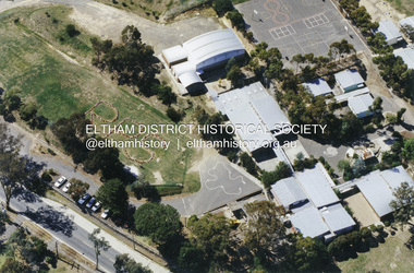 Eltham District Historical Society Inc
Document - Archive Box, 1570 Main Road, Research (Research Primary School)
Contents: 1. Andrew Lemon's Working File of Return to Research Andrew Lemon's Working File for his 1989 book, “Return to Research: A Centenary History of Research Primary School" (EDHS_00867). Includes a disassembled copy of the book. (All other documentation and photos passed to Research Primary School 3 September 2013) 1.1. EDHS_05004 - Cassette Tape of "Afternoon Tea with Senior Residents Nov 1st 1984" Reminiscences, chit chat and banter between group of senior citizens at an afternoon tea held for them at Research Primary School. 1.2. School Register 1935-1994 (Box 1) Photocopy of Research Primary School register from 1935 to 1994 (originals held at school) From 1994 onwards registrations were made online via the Education Department CASES system. 1.3. School Register A-Z 1935-1987 (Box 2) Computer print-out of alphabetized register 1935-87 (Research Primary School) (Done by David and Sue Grigg in 1987 from the register) Contains some extra details/corrections/current addresses Plus disks containing this data (not housed in box – there is a separate floppy disc box containing several 5 ¾” and 3 ½” floppy disks which are not readable as no hardware/software to support) 1.4. Research Locality History (Yellow Folder 1) Research Locality History Newspaper cuttings, Photocopies etc Collection for Research Primary School History 1989 Contents • 3 x photocopies (A3) regarding sale of Raglan Estate, Research [2 x A3 and 1 x composite A3 colour photocopy] • Souvenir Map of area with pictures of historical items and wild life - A Visitor's Guide Map; ELTHAM, WARRANDYTE and Environs (see also EDHS_01633-1) • EO article 26 Mar 1897 "Research State School picnic expedition to Mordialloc" • TA article 25 Jul 30" Research Affairs" plus an add for J Ingram's Research Bakery • DVN articles 14 Jan 69 (2 pages) "Research Fire Victim (Bill Pelling) still in hospital" • DVN 14 Jan 69 Page of Deaths, In Memories, Obituaries, Church Notices, Public Notices and Notices • Age article 24 Jan 84 "Eltham before the Mud Bricks" • DVN article 21 Oct 86 "Facing Good and Bad Times with enthusiasm - Keith Maxwell" • DVN article 29 Aug 87 "Eltham - the historic haven" • DVN article 25 Aug 87 "Eltham - a piece of living history, (the historic haven cont…)" • DVN article 20 Oct 87 "When push bikes were made for touring - Sam Howard" • 6 x pages of what appear to be various student's workbooks/ projects from 1944/45 era • ''They lost their homes- Historical places go at Research" plus other articles on fires 8 Jan 69 [Located in Folder 2] • DVN articles 23 Oct 84 "Centenary Plans" & Folklore surrounds Research township" [Located in Folder 2] • DVN article 23 Sep 86 "The teacher who had cut cane but never used one" Frank Sheehan (3 copies) [Located in Folder 2] • 2 x copies of booklet "Memories of Eltham" [Located in Folder 3] • Photocopy of subdivision Parish of Nillumbik [Located in Folder 4] DVN = Diamond Valley News, EO = Evelyn Observer TA= The Advertiser 1.5. Copies of items held by Public Records Office Victoria (Yellow Folder 2) Copies of items held by Public Records Office Photos and display items from Research Primary School Centenary August 19, 1989 • Laminated photocopy: “State School No. 2959, Copy of the above school property,” signed Henry L. Cole 18.6.91 • Photocopy: Petition for a school at Research, 13/11/1888; Public Record Office Victoria School Building File – School 2959 CUPRS 795/1717 • Photocopy: Negotiation to buy school site – part of Allotment 2, owned by the West family (copy attached to letter) 15/1/1890; Public Record Office Victoria School Building File – School 2959 CUPRS 795/1717 • Photocopy: Frank Scott, Head Teacher Research 1904-1907, letter of explanation (first page) to Department re poor results by pupils at the school, 24/8/1907; Public Record Office Victoria School Building File – 640 / School 2959 • Photocopy: Anton Brinkkotter’s Certificate for Regular Attendance 1908 (This was ‘traded in’ in 1911 for a certificate to mark six years without missing a day of school; Public Record Office Victoria School Building File – 640 / School 2959 for 1911 • Photocopy: Education Department Memorandum 1949 re need for extensions and improvements; Public Record Office Victoria School Building File – 795 / School 2959 • Photocopy: Looking to the future about expanding site for additional land for play space, 1950, Education Department Inspector to Department; Public Record Office Victoria School Building File – 795 / School 2959 • Photocopy (laminated, 2 sheets) First School Fire -1953 copy of Police Report. The old school building was badly damaged but repaired. It burnt down in 1976; Public Record Office Victoria School Building File – 795 / School 2959 • Photocopy: The Argus (28 July 1953) & the (Sun 28 July 1953) Two newspaper cuttings and notes re school fire 1953; Public Record Office Victoria School Building File – / School 2959 • Photocopy: Head Teacher Reg Jackman expresses concern to Education Department about conditions as he takes charge of Research State School, 1957; Public Record Office Victoria School Building File – 640 / School 2959 • Photo print (x2) of Education Department Qualifications and Certificates, Lyla Dickson, State School. (1) Print missing (2) Education department Victoria, Merit Certificate, This is to certify that Lyla Dickson has completed satisfactorily the Course of Study presented for the Eight Grade in Elementary Schools, dated at research Elementary School, this 20th day of November A.D. 1923 • Copy of original photo owned by Nell Howard “Fancy dress night in the school house – 1920s”, black and white print, 10.5 x 18 cm, attached to A4 photocopy of photo with names inscribed10.5 x 18 cm • Copy of original photo (stamped Reynolds Collection), black and white print, 24.5 x 16 cm, attached to paper sheet 37.6 x 25.5 cm, inscribed “Miss Doney” and “Elizabeth Doney and her family owned and ran Research’s Store and Post Office for many years after buying the property from the wests. This land surrounded the school site and includes today’s [1989] Kanandah Ct, Raglan St and shops” • Black and white photo print, 20 x 25 cm, Reconstruction of Main Road in front of Research Primary School, August 1989 • Black and white photo print, 20 x 25 cm, Eastern end of old oval, Research Primary School, 1989 • Black and white photo print, 20 x 25 cm, Portable Buildings, Research Primary School, 1989 • Black and white photo print, 20 x 25 cm, Gymnasium, Research Primary School, 1989 • Black and white photo print, 20 x 25 cm, Administrative Art Building, Research Primary School, c.1989 • Black and white photo print, 20 x 25 cm, Betty Kicker, Cleaner at Research Primary School, c.1989. Betty worked at the school from early 1970s to 1990s 1.6. ‘Memories of Research 1951-1968’ (Yellow Folder 3) Interview by Sue Grigg of Florence Egglestone for publication in Return to Research. Original handwritten notes, ‘Memories of Research 1951-1968’ 1.7. Centenary Committee Minutes & Newsletters (Yellow Folder 4) Centenary Committee Minutes and Newsletters Information regarding attendance of 100th anniversary including lists of staff contact details 1983-1986 Request (1985) to Shire of Eltham Historical Society for information and memorabilia • Letter: Ann Bouchier, Convenor – Centenary Committee, Research Primary School to R. Yeoman, Shire of Eltham Historical Society, 15 October 1985; enquiring about memorabilia etc that could be used in a proposed compilation on the “History of the School.” • Minutes of Meeting, Centenary Sub-Committee, Research Primary School Council o 17 June 1985. Also includes a list of general aim, specific aims and methods for the research Primary School Centenary - 1989 o 15 October 1985. o 17 September 1986. o 20 August 1987. o 2 May 1988. o 9 June 1988. o 22 August 1988. o 12 October 1988. o 24 November 1988. o 17 April 1989. o 24 July 1989. • Outline of Historical Events 1884-1954 (3 pages) • Centenary Newsletters o Number 1 (1989) o Number 2 (1989) o Number 3 (1989) o Newsletter (c. Aug. 1989) • Information re attendance of 100th Anniversary, Research Primary School, 19 August 1989 o Research Primary School – Staff 1984 (includes Name, Address, Telephone) o Research Primary School – Staff 1985 (includes Name, Address, Telephone) o Research Primary School – Staff 1986 (includes Name, Address, Telephone) o Emergency Teacher List 1983 o Emergency Teacher List 1986 o Previous teachers 1984 on • Quotation No. 733, Major Graphics for Engraved Brass Commemorative Plaque for opening of School Gymnasium • Centenary Invitation; Program and Souvenir and Chicken & Champagne Supper order forms • Various Centenary Invitation lists with notations, and various returned RSVPs • Centenary Program and map • Photocopy: 11 pages typed with hand corrections, draft manuscript for Andrew Lemon’s book, Return to Research (pages 13-24) • Bulletin: “I’m an Aussie” Week – 15th-19th April 10/4/85 • Bulletin: Research Centenary 26/4/88 • Bulletin: Official Centenary Logo For Research Primary School 15/12/88 • Bulletin: Centenary School Activity – “Colonial School” 23/5/89 • Bulletin: Centenary Activity Days – Monday, 14th August, Tuesday, 15th August 7/8/89 • Advertisement: A3 photocopy, Centenary Bush Dance, Sat. 4th March featuring “Paradiddle” Bush Band • Photocopy Master: Invitation (blank) to attend “Return to Research” celebration and Official Opening of the School Gymnasium on Saturday, August 19th from 1.00p.m. to 5.00p.m. and attached RSVP (also includes yellow paper sample -blank) • Photocopy Master: Tickets for Centenary Chicken & Champagne Supper, Friday, 18th August 1989, 7.30p.m., $5.00 per head (2 yellow paper samples marked on reverse ‘13’ and ‘55’) • Photocopy Master: Centenary Gift Donated by slips including multiple blank samples • Promotional Notices o Letter, Robert Wenn, Principal, 29 November 1988 for placement of “HELP WANTED” in Public Notices of The Age o Information provided to Ian Reid Real Estate Agent for Board to promote Centenary Bush Dance Paradiddle Band, Saturday 4 March 1989 o Notice Board promoting ‘Old Time’ Gala Fete Saturday 17 June 1989 o Letter, Robert Wenn, Principal, 24 August 1989 to Ian Reid Real Estate thanking for support of Centenary celebration and successful book launch and seeking further support for next event being school musical production “Spirit of Research” written by Andrew Lemon to be performed December 7th. 1.8. 1989 Research Primary School Centenary Visitors Register and Sue Grigg Correspondence (Red Folder) Sue Grigg’s Folder of Visitors to 1989 Centenary Celebrations and correspondence to Sue Grigg as organiser of Centenary Celebrations • 22 A3 Sheets of 1989 Research Primary School Centenary Visitors Register (approx. 238 entries) • Correspondence to Sue Grigg as Organizer of Centenary Celebrations o Trace B? – Ingram, Dunolly, 30 January 1990 re photo of Ingrams Road. Includes hand drawn map of various buildings on Ingrams Road. Also black and white print copy (12.5 x 17.5 cm) of photo of Ingrams and Main Road (possibly one sent to her) – see SEPP_0511 o Barbara Booth (nee Coles); thanks for wonderful celebration o Len and Marlene Parsons, 21 August 1989 o Mrs R. Towers, n.d. thanks for school photo ordered o Winifred L. Lade, 7 August 1989, gg grandparents William and Mary Crozier, daughter Sarah married Thomas Baillie (her g grandparents). Thomas Baillie was one of the petitioners for the school o Winifred L. Lade, n.d., thanks for photo and map o Carol Mathews, thanks for celebrations and payments for photos. Written on reverse of Sue Grigg’s letter to her of 19 September 1989 o Kenneth Ingram, Monday 14th, thanks for invitation but unable to attend • Photo of Ingrams and Main Road 1.9. Student Photos c.1970s (Buff Folder 1) [Not in Archive Box] Quantity of photos of students taken by Mrs Avril Baker (Staff Member) In 1970s 1.10. 1989 Centenary Questionnaires (Buff Folder 2) Research Primary School, 1989 Centenary Questionnaires from school families (approx. 190 responses) 1.11. Archive and Class Photos 1890s-1961 (Buff Folder 3) • Archive photographs of Research and District; 10 x 15 cm prints and digital files on thumb drive (copied to Collection catalogue) o RPS 1- Henry Cole Head Teacher 1891 to 1903. Photo from Mrs E. Williams o RPS 2 - Mary Jane Cole with eldest daughter Doris c 1905 o RPS 3 - Wedding Photo Mary Jane Rodda and Henry Cole o RPS 4 - Joseph Rodda of Chun Grove, Research o RPS 5 - Walter Rodda 1917 son of Joseph Rodda o RPS 6- Henry Cole and Pupils 1897 (Reynolds Collection) o RPS 7 - Elizabeth Doney (Reynolds Collections) o RPS 8 - Doney's Store early 1960's o RPS 9 - Main Road Research to Left, lngrams Road to Right o RPS 10- Main Road Eltham from Griggs family o RPS 11- Eltham near Station from Griggs family o RPS 12 - The Main Street Eltham from Griggs family (Rose Series 4344) o RPS 13 - The Rev and Mrs Thomas Cole. Parents of Henry Cole o RPS 14- Henry Cole as a boy with older brother Tom. From Mrs E. Williams. o RPS 15- Mary Jane Rodda as Mrs Henry Cole, Sewing Mistress Research State School 1891 to 1897 o RPS 16 - Etta Rodda Sewing Mistress Research State School 1897 -1904 o RPS 17 - Frederick Rodda son of Joseph Rodda o RPS 18- Bush Fires 1963 o RPS 19 - The view to the northeast from the top of the School Grounds 1989 o RPS 20- Edwin Rodda son of Joseph Rodda • Class and Staff photos, some with lists and names for identification [see separate folder of digital files – no hard copies in folder] Decade Years Represented 1890-1899 1897 1900-1909 1900, 1904 1910-1919 1910 1920-1929 1922, 1925 1930-1939 1930, 1932, 1937 1940-1949 1940, 1942 1950-1959 1950, 1951, 1952, 1953, 1954, 1955, 1956, 1957, 1958 1960-1969 1960, 1961, 1969 1970-1979 1970, 1971, 1972, 1973, 1975, 1976, 1977, 1978, 1979 Staff: 1971, 1976, 1978, 1979 1980-1989 1980, 1981, 1982, 1983, 1984, 1985, 1986, 1987, 1988, 1989 Staff: 1981, 1982, 1985, 1986, 1987, 1988, 1989 1990-1999 1990, 1991, 1994, 1995, 1996, 1997, 1998, 1999 Staff: 1990, 1994, 1995, 1996, 1998, 1999 2000-2009 2000, 2001, 2002, 2003, 2004, 2005, 2006, 2007, 2008, 2009 Staff: 2000, 2002, 2003, 2004, 2005, 2006, 2007, 2008, 2009 2010-2019 2010, 2011, 2012, 2013, 2014 Staff: 2010, 2011, 2012, 2013, 2014 • Class names; 4 pages handwritten and 2 numbered diagrams of Class names: o 1942 whole school o 1975 Grade 1 o 1976 Grade 2-3 o 1977 Grade 3 o 1978 Grade 4 o 1979 Grade 5 o 1980 Grade 6 • Negatives of photographs, 1 x roll of 36 and contact prints, copied at or for the Centenary 1989 o Neg. S – same as Neg. 27 o Neg. 1 – 1961 2/3 o Neg. 2 – 1960 5/6 o Neg. 3 – 1960 2/3 o Neg. 4 – 1960 Prep o Neg. 5 – 1957 Gr 2 o Neg. 6 – 1956 1A & II o Neg. 7 – Prep & I o Neg. 8 - 1955 o Neg. 9 – 1955 I & II o Neg. 10 – 1958 Gr II o Neg. 11 - 1960 3A & 4 o Neg. 12 – 1961 4 & 5 o Neg. 13 – same as Neg. 17 o Neg. 14 - 1925 o Neg. 15 - 1930 o Neg. 16 - 1942 o Neg. 17 – 1927 whole school o Neg. 18 - 1937 o Neg. 19 - 1932 o Neg. 20 - 1953 o Neg. 21 – 1951 Prep - 3 o Neg. 22 - 1954 o Neg. 23 - 1952 o Neg. 24 – Gr 4-7 o Neg. 25 – 1956 V & VI o Neg. 26 - 1940 o Neg. 27 – 1961 Gr 1 & 2 o Neg. 28 – SEPP_0610 (and 12.5 x 17.5 cm black and white print) o Neg. 29 – SEPP_0611 (and 12.5 x 17.5 cm black and white print) o Neg. 30 – SEPP_0612 o Neg. 31 – SEPP_0516 o Neg. 32 – SEPP_0509 (and 12.5 x 17.5 cm black and white print) o Neg. 33 – SEPP_0510 o Neg. 34 – SEPP_0511 o Neg. 35 – SEPP_0513 • Requests for copies of photos including explanation from Andrew Lemon that copies were made by camera of original photos provided by their owners • Colour photo print (copy of original), 12.5 x 17.5 cm, Doney’s Store, Main Road, Research, early 1960s including black and white photocopy of original print showing slightly wider field of view • Colour photo print, 10 x 15 cm, marked on reverse “19A” and “1 copy”, Aerial view of Research Primary School, c.1989 • Black and white print, 9 x 9 cm, Burnt out houses Ingrams Road Research near Cassell's Road after 1963 bushfire • Black and white print, 9 x 9 cm, Sight see-ers Ingrams Road Research near Cassell's Road after 1963 bushfire • Black and white photo print (copy of original), 20 x 25 cm, A memento of the Eltham Higher Elementary School Past Pupils Association Ball, Research Hall, 9 October 1966; inscribed and stamped on reverse “Reynolds Collection” • Colour photo print (copy of original), Kodak A4 photo paper, Pittaways cnr Main Road and Parsons Road c.1968 • Colour photo print (copy of original), Kodak A4 photo paper, Pittaways cnr Main Road and Parsons Road, my dad’s boat, c.1970, • Black and white photocopies of photos from Reynolds Collection o EDHS_00799-20 - The Research Hotel o EDHS_00799-22 - General Store, Research o EDHS_00799-27 – Plumtree Creek, Blashik family home, Ingrams Road o EDHS_00799-30 - Research o EDHS_00799-34 - Research Gully Bridge, Research Gully Road, c.1895 o EDHS_00799-35 - Research o EDHS_00799-37 - Waiting for the taxi-bus, Main Road, Research o SEPP_0524 - A Bush Home - Research, Vic.. 1.12. Research Primary School Centenary 1989 Display Photos (Buff Folder 4) 7 display pages, 37.8 x 25.5 cm, with 10 x 15 cm sepia coloured reproduction photographs attached and handwritten notations [some have come loose or missing] • Henry Cole, Head Teacher, Research, 1891-1903 o RPS-14 Henry Cole as a boy with his older brother Tom o 2 photos as a young man (missing) • Rodda Family, Jospeh B Rodda and two of his daughters o RPS-4 Joseph Rodda of Chun Grove Research o RPS-15 Mary Jane Rodda as Mrs Henry Cole, Sewing Mistress, Research State School, 1891-1897 o RPS-16 Ettie Rodda, Sewing Mistress, Research State School, 1897-1904 • Cole Family o Henry Cole, Head Teacher, 1891-1903 o RPS-3 Wedding photo 1894, Mary Jane Rodda and Henry Cole (missing) o RPS-2 Mary Jane Cole with eldest daughter, Doris, c.1905 (missing) • Cole Family; The Rev. and Mrs Thomas Cole, parents of Henry Cole o Rev. Thomas Cole o Mrs Thomas Cole o RPS-13 The Rev & Mrs Thomas Cole parents of Henry Cole • Cole Family o Reg Cole, O.B.E., as Town Clerk of Hobart meeting Queen Elizabeth and Prince Phillip, 1954. HJR (Reg) Cole was the eldest child of Henry and Mary Jane Cole, and was a pupil at Research State School c.1900-1903 • Sons of Joseph B. Rodda of ‘Chune Grove’, Research o RPS-17 Frederick Rodda o RPS-20 Edwin Rodda o RPS-5 Walter Rodda, 1917 • The Aqueduct (20 x 25 cm black and white reproduction print); built for opening in 1891 to take water from Maroondah to Reservoir (Reynolds Collection) 1.13. Class Photos (photocopies) - with names identified at Centenary 1989 (Buff Folder 5) [Not in Archive Box] Research Primary School- Class Photos (photocopies) -with names identified at Centenary 1989 1964 - 1984 1.14. News Paper Cuttings (Folder 2) News Paper Cuttings • Diamond Valley News - 23 Oct 1984-Centenary Plans - Folklore surrounding Research Township • Diamond Valley News 23 September 1986 - The Teacher who had cut can but never used one (4 copies) • Diamond Valley News- 20 October 1987 - When push bikes were made for touring (2 copies) • Diamond Valley News-14 January 1969 - They lost their homes (Historical places go at Research) • Diamond Valley News- 14 January 1969 - Bush Havoc ( 10 houses burnt at Warrandyte) • The Age - 24 January 1984- Eltham before the Mud Brick • Diamond Valley News - 14 January 1969- First Fire Call came at 10:25 am • Diamond Valley News - 14 January 1969 - Black Wednesday • The Advertiser- 25 July 1930- Research Affairs and add Research Bakery • Evelyn Observer - 26 March 1897 - Research State School part of a district schools expedition to Mordialloc (2 copies) • Diamond Valley News- 21 October 1986- Facing good and bad times with enthusiasm • Diamond Valley News- 14 January 1969 -Obituary David Leslie Mitchener • Diamond Valley News- 25 August 1987 - Eltham - the historic haven (2 copies) • Diamond Valley News-14 January 1969 - Research fire victim still in hospital 1.15. Reminiscences (Folder 3) • Memories of Eltham (Multiple authors) (2 copies) • List of names of children who attended Research Primary School as recalled by Kenneth Ingram (b.1907) provided in 1987 by his niece Grace Burrows (nee Ingram) including names of students and teachers she recalled from her time at school 1936-1941 • Photocopy of Interview by Sue Grigg of Florence Egglestone for publication in Return to Research, ‘Memories of Research 1951-1968’. [Original handwritten version in Yellow Folder 3.] 1.16. School Site and Buildings (Folder 4) • 3 x photocopies of photos of early school building • Raglan Estate Research • Plan of subdivisions Research 1920s • 1981 Education Department Building Operation process to be followed in the event of criminal damage 1.17. School Historical Documents (Folder 5) School Historical Documents • Certificate of Merit Ernest Reynolds • Inventory of Books and Equipment 1891 • Letter from Teacher Frank Scott explain poor results • Letter from Henry Cole recommending appointment of Mary Jane Rodda as Sewing Mistress • Special Certificate for Regular Attendance Anton Brinkkotter (2 copies • Certificate of Merit Anton Brinkkotter 1911 • Merit Certificate Lyla Dickson 1922 • Special Certificate for Regular Attendance Margery Palmer 1927 • Letter from Head teacher Reg Jackman 1957 • Petition to Education Dept 1884 from Research Gully to open a school • Joseph Mankey's complaints about temporary classroom 1890 • Research 1890 - Plan of one acre site to be purchased by education Dept for permanent school • List of buildings and dates • Need for extensions and improvements 1949 • Looking to the Future 1950 • Negotiations to buy school site 1890 2. Magenta Folio 1. USB drive containing • Class photos 1897-2014 • Class photo names • List of head teachers/Principals 1989-2014 • List of Infant Productions 2001-2010 • School photo names typed up identified at centenary reunion 1925-1984 • List of school camps 1964-2014 • List of Senior Productions 1986-2014 • Staff list 1989-2014 • List of grades by year taught by Mrs Avril Baker 1976-2010 2. CD of School and Class Photos 2013-2014 including laminated print of school photo 2014 3. 2 x CD of photos of Research Remembered. CD 1 containing 20 images of various activities from Centenary Celebrations and CD 2 containing 12 images of various student activities (1990s) 3. Clear Folio 1. Additional RPS Material • History of Research State School No. 2959; F.P. Sheehan (Principal) and Mrs M. Allwood (Historian) – duplicate copy of EDHS_03095-1570 held in Main Road property file. • Invitation; The Official Opening of 4 New Classrooms & Library Extension • Program; The Official Opening of 4 New Classrooms & Library Extension, 27 April 1996 • News clipping; Remember Sleepy Swipers Gully? Diamond Valley News, July 22, 1980, pp28-29 • Site plan of building layouts • Colour photo paper print of Rob Wenn’s retirement, June 1999 • Email from former teacher Brett Barnett sent March 2008 (teacher 1967-1980) with references to pet python that students would look after, and which perished when original school building used as a library burnt down • 2 letters (2009) from Peta McGinley offering some papers and photos for school archives. Her father, Rix McGinley was Principal for 1984 till his retirement in 1987. She was also a casual Relief Teacher in her first year of teaching in 1984. • List of 60 names associated with engraved bricks 2. 100th Anniversary 1989 • News clipping; Celebrations and nostalgia at school, Diamond Valley News, Tuesday, August 29, 1989, p28 3. 120th Anniversary 2009 • Notes of contact details of some former students who expressed interest in a reunion 4. 125th Anniversary 24 August 2014 • 3 pages handwritten of reminiscences of a group of mums whose children attended RPS during the 1980s. • 2 pages dated 29 March 2014 typed by Janet Page (nee Zambra) of reminiscences of her years at school (1948-1954) in support of 125th Anniversary Reunion (24 August 2014) sent to Joy Pagan with some queries noted by Maggie Sakko • Reminisces (single sheet double sided handwritten) of teacher Mrs Jacqui Edwards 1989-2001 retired and Casual Relief Teacher 2001-2014 sent to Maggie Sakko in support for 125th Anniversary book and follow up queries from Maggie Sakko (18 July 2014) • List of regular Casual Relief Teachers established by Brooke and Maria for Maggie Sakko • Two pages of working notes • News clipping: Ring in the years, Diamond Valley Leader, Wednesday, August 27, 2014, p1 – Illustrated – “Koray, Aidan and Lasenya helped ring in the 125th anniversary of Research Primary School. A huge reunion brought together past and present students and staff who reminisced about their school days. Report Page 14” • News clipping: School back to the past, Diamond Valley Leader, Wednesday, August 27, 2014, p14 – Illustrated (2 copies) • Poster: Arbor Week June 23-29 (2008) – Arbor Week is the same age as Research Primary School – note written on poster to possibly include tree planting as part of 125th celebrations 5. Centenary of Federation Medal presented to students of Research Primary School (2001) by former student, Miss Ivy Reynolds • Letter: Ivy Reynolds to staff and children, May 22, 2001, letter of thanks for privilege of sharing the celebrations with her • 9 x laminated paper colour prints of students with medals and Ivy Reynolds main road, property, research (vic.), research state school no. 2959, caledonian gold field, swiper's gully, wallaby town, research gully, discovery gold plenty ranges, fountain of friendship hotel, ray morris, alice russell, norma family, bettison family, reynolds family, william west, joseph m makey, henry james cole, mary jane rodda, florissa milton, f p sheehan, m allwood, research hotel -
 Ringwood and District Historical Society
Document - Research Notes, Richard Carter, Land Subdivisions in Ringwood 1890-1950
Handwritten table listing main local pre-1950s subdivisions in the Ringwood area, with estate names, streets, number of allotments for sale, and where known, vendor agent, LP (Lodged Plan) title registration number, and auction/sale date, some with sale price.Pg1 RINGWOOD STATION ESTATE LP3070 (Year?) Station Street, William Street (now Kendall Street), Wantirna Road, Station Street Pg1 RINGWOOD TOWNSHIP ESTATE LP5577 (1913) Station Road (now Warrandyte Road), Pratt Street (part now Aird Street), Whitehorse Road Pg2 RINGWOOD ORCHARD ESTATE LP4315 (1914) Brysons Road, Hillcrest Road, Anzac Avenue, Sulva Road Pg3 RINGWOOD RAILWAY ESTATE LP7522 (1918) Whitehorse Road (now Mount Dandenong Road), Dublin Road, Freeman Street, Patterson Street, Bona Street Pg4 THE RINGWOOD ESTATE LP7578 (1919) Warrandyte Road, Hobart Street, Paxton Street, Arnold Street Pg5 GARDEN FARMS ESTATE (LP?) (1919) Canterbury Road, Armstrong Road, Bungalook Road, Orchard Road, Bayswater Road (now Mountain Highway) Pg6 THE RINGWOOD ESTATE (SECOND SUB-DIVISION) LP7604 (1919) Warrandyte Road, Tamar Street, Derwent Street, Mersey Street Pg7 RINGWOOD STATION ESTATE LP7703 (1919) Bedford Road, Williams Grove (now Lena Grove) Pg8 RINGWOOD TOWNSHIP ESTATE LP8198 (1919) Wantirna Road, Ellison Street, Haig Street, Greenwood Avenue Pg9 EASTFIELD ESTATE (LP?) (1920) Eastfield Road, Longview Road, Pleasant Rise, The Mount Pg10 ELECTRIC RAILWAY ESTATE RINGWOOD LP9473 (1922) Campbell Street, Myrtle Avenue, George Street (now Tudor Court), Henry Street (now Myrtle Avenue), Williams Grove (now Lena Grove) Pg11 RINGWOOD PARK ESTATE LP7884 (1922 - two stages) Wonga Road (now Loughnan Road), William Street, Andrew Street, Harrison Street Pg12 HEATHMONT STATION ESTATE LP11009 (Date? - after 1922) Lisgoold Street, Viviani Crescent, Balrour Avenue, Station Street (now part Heathmont Road and part Wainui Street) Pg13 RINGWOOD RAILWAY ESTATE LP10507 (1923) Whitehorse Road, Sherbrooke Avenue, Burwood Avenue, Bonview Avenue, Heatherbrae Avenue, Grant Crescent Pg14 GARDEN HOMES ESTATE (LP?) (1923) Mullum Road, The Centreway, Wattle Crescent (now Wattle Avenue) Reserve Crescent (now Reserve Road) Pg15 DUBLIN ROAD ESTATE LP11993 (1923) Alexandra Road, Vonadawn Avenue, Green Street, Wood Street, Howard Avenue, Bedford Road, Dublin Road Pg16 CARLINGA ESTATE RINGWOOD LP9620 (1923) Bourke Street, Bond Street, Ringwood Street Pg17 PRATT'S JUNCTION ESTATE (LP?) (1923) Junction Street, Georges Road, Oliver Street, Whitehorse Road Pg18 EAST RINGWOOD ESTATE LP10492 (1923) Bona Street, Patterson Street, Miller Grove, Fairview Avenue, Eastfield Road, Whitehorse Road (now Mount Dandenong Road) Pg19 COLEMAN'S HEATHMONT ESTATE LP9974 (1923) Canterbury Road, Bedford Road, Alvena Crescent, Coleman Street, Leonard Street (now Royal Avenue) Pg20 RINGWOOD HEIGHTS ESTATE LP10506 (1924) Whitehorse Road, Bonview Avenue, Grant Crescent, Hillcrest Avenue, Heatherbrae Avenue, Margaret Street, Mary Street Pg21 EAST RINGWOOD STATION ESTATE LP10551 (1924) Knaith Road, Wenwood Street, Lois Street, Victoria Street, Station Street (now Railway Avenue) Pg22 GRAND VIEW ESTATE LP11019 (1924) Whitehorse Road, Rupert Street, Herbert Street, Leonard Street Pg23 RINGWOOD RAILWAY ESTATE & RINGWOOD HEIGHTS ESTATE - FINAL SECTIONS LP10506 & LP10507 (1924) Whitehorse Road, Sherbrooke Avenue, Burwood Avenue, Bonview Avenue, Heatherbrae Avenue, Margaret Street, Mary Street, Grant Crescent Pg24 RINGWOOD EAST ELECTRIC STATION ESTATE (LP?) (1924) Railway Parade (now Patterrson Street), Federal Road, Howship Avenue (part now French Street), Dublin Road, Rosedale Crescent Pg25 BEDFORD PARK (now Ringwood Secondary College) (LP?) (1924) Bedford Road, Adams Street, Anderson Street, Joyce Street, Graham Road Pg26 CROWN JEWEL ESTATE LP11645 (Private sales after 1924) Mount Dandenong Road, Mirabel Avenue, Valda Avenue, Evon Avenue, Velma Grove Pg27 GRAND CENTRAL ESTATE LP10917 (1925) Heathmont Road, Great Ryrie Street, Douglas Street, Garden Street, Bellevue Avenue Pg28 RINGWOOD (unnamed estate - 1926) Nelson Street, Seymour Street, Whitehorse Road Pg29 EAST RINGWOOD RAILWAY STATION ESTATE (YEAR? - 25 shops 60 villas) Railway Avenue, Dublin Road, Lawrence Grove, Stanley Avenue, Knaith Road Pg30 CHARM VIEW ESTATE (LP?) (year? - after 1926) Canterbury Road, Heathmont Road, Dickasons Road, Bennjett Avenue, Orchid Street Pg31 SUNBEAM ESTATE LP12150 (Circa 1925) Govt Road (now Old Lilydale Road), Sunbeam Avenue, Holland Road, Everard Street (now Everard Road) Pg32 FAIRVIEW ESTATE EAST RINGWOOD LP10853 (Circa 1924) Eastfield Road, Patterson Street, Margaret Street (now Short Street) Pg33 EAST RINGWOOD TOWNSHIP ESTATE LP3025 (Circa 1924 - 35 allotments) Mount Dandenong Road, Grey Street, Eastfield Road Pg34 EAST RINGWOOD TOWNSHIP ESTATE LP3025 (Circa 1924 - 49 allotments) and STATE SCHOOL ESTATE (26 allotments) and EAST RINGWOOD STATION ESTATE (14 shop sites) Mount Dandenong Road, Grety Street, Dunn Street, Eastfield Road, King Street, Holland Road, Dublin Road, Patterson Street, Bona Street Pg35 EAST RINGWOOD CENTRAL ESTATE LP17004 (1948) Knaith Road, Shasta Avenue, Talofa Avenue, Russet Road, Dublin Road Pg36 WARE ESTATE LP43360 (1958) Ware Crescent, Davey Drive, Grey Road (now Grey Street), Mount Dandenong Road Pg37 Lot 57 Kendall Street LP3070 (1939) £75.0.0 Pg37 Lot 14 LP7346 (year?) £225 Pg37 Lot 8 WHITE HORSE ESTATE LP14010 (year?) Maroondah Hwy, Seymour Street £98.9.0 Pg37 Lots 4-14 incl. LP10902 (year?) £300 Pg37 Lots 69&70 LP2216 (1939) Bedford Road, Pitt Street £500 Pg37 Lots 60&70 LP2216 (year?) £460 Pg37 MOUNTAIN VIEW ESTATE LP10902 (1936) Lots 1&2, 19-22 Wantirna Road, Daisy Street £50 Pg38 RAILWAY STATION ESTATE RINGWOOD EAST LP7522 (1925) Lots 16 to 19 £250 Pg38 RINGWOOD PARK ESTATE (LP?) (1924) Lot 112 Munro Street £230 Pg38 RINGWOOD TOWNSHIP ESTATE (LP?) (1925) Lot 57 Wantirna Road £850 Pg38 ELECTRIC RAILWAY ESTATE LP9473 (1925) Lot 98 & 99 £180 (30/- foot) Pg38 ELECTRIC RAILWAY ESTATE LP9473 (year?) Lot 100 £233.12.6 incl improvements (£2.12.6 foot) Pg38 Lot 22&23 Bedford Road Heathmont (LP & year?) £675 incl improvements Pg39 Lot 9 Mullum Mullum Road LP8221 (1923) £150 Pg39 Lot 27 Haig Street LP8198 (1925) £825 Pg39 Lot 56 Haig Street cnr Wantirna Road LP8198 (1923) £171 Pg39 Lots 3 & 4 Loughnan Road LP9626 (192?) £147 Pg39 Lots 98 & 99 Myrtle Avenue LP9473 (1925) £180 Pg39 Lots 80 & 81 Myrtle Avenue LP9473 (1929) £150 Pg39 Lot 30 Sherbrooke Avenue LP10507 (1926) £700 incl improvements Pg40 Lot 10 (year?) LP7703 £750 Pg40 Lot 36 (year?) LP7522 £25 Pg40 Lot 38 Pitt Street LP2216 (year?) £350 Pg40 Lot 7 Dublin Road cnr Green Street LP11993 (year?) £300 -
 Dandenong/Cranbourne RSL Sub Branch
Memorabilia - Book of Servicemens names, S. S. & A. F.A. Dandenong. Lest We Forget, Circa 1940s
Large hard covered book containing names and photographs of 159 deceased Servicemen. Lest We Forget. Roll of Honor. Dedicated to the gallant Sons and Daughters in the Fighting Services of the Dandenong Branch of the Sailors Soldiers and Airmen,s Fathers Association of Victoria. Let not their Sacrifices be in Vain. Photographs are of the following. 143736 RAAF. Y.D Bending. 128756 RAAF LAC R. J. Berry. VX 66913 AIF Pte. J. M. Bland. VX 67586 AIF Sgt. C. Boote. VX 37378 AIF Pte. H. E. Bould. VX 72867 AIF Pte. C. J. Bould. 59887 RAAF LAC. V. A. Bould. VX 41802 AIF Dvr. J. Bradley. VX 113184 AIF Sgt. R. B. Brooks. VX 109393 AIF Sgt. A. Y. Brooks. 49145 RAAF Corp. R. J. Brooks. VX 64333 AIF Corp. D. L. Brumley. WX 9742 AIF. Pte. T. H. Budgeon. VX 85885 AIF Gunner W. M. Buttler. VX 137411 AIF Pte. A.W Cameron. 400037 RAAF Flt. Lieut. W J Canterbury. VX 85253 AIF Capt. T C Canterbury. 49218 RAAF Lac. S E Cannard. VX 24291 AIF Capt. A L Carthew. VX 132044 AIF Gunner G Chandler. VX 68692 AIF Bdr. A J Chandler. 128776 RAAF Acr. D Chrisfield. VX 90726 AIF Gunner W J Chrisfield. 401631 RAAF Flt. Sgt. S Cooper. W2091 RAN Stoker H J B Cooper. VX52731 AIF Cpl. C B Cooper. VX92695 AIF Pte. J M Cornish. 13774 RAAF Flt. Sgt. G R Coulthard. RAN Stoker H F Cross. RAN Stoker. R O Cross. VX15688 AIF Bmd. E J Curran. 42998 RAAF Sgt. R F Dawson. VX 5835 AIF Pte. R R N Dobson. VX 110898 AIF Gunner R B Dunn. RAN Stoker E W Eades. 401424 RAAF Pilot Off. H L Edgoose. VX 89563 AIF Corp. A R Ewart. 401817 RAF Flg. Off. F P Field. VX 2115 AIF Sgt. J E Ford. VX 53019 AIF Dvr. M G Greyling. VX 100355 AIF LCorp. V F Greyling. VX 137580 AIF Corp.J J Greene. VX 138491 AIF Pte. D M Greene. VX 5828 AIF Corp. G S Hamilton. VX 85863 AIF Gunner. B W Hamilton. VX 80141 AIF Gunner A W Hamilton. VX 51804 AIF Gunner E W Harden. 41632 RAAF Lac. T J Hardy. 121213 RAAF Lac. C W Harvey. VX 29054 AIF Pte. F Howard. VX 11914 AIF Corp.D J Hunter. VX 123189 AIF Signaler A W Hussey. VX 147815 AIF Sapper K B Hussey. VX 42893 AIF Sigr. J Hussey. VX 15925 AIF Pte. D R Irvine. 41389 RAAF A/Crew. M Irvine. VX 52919 AIF Gunner A F Issac. VX 136374 W/Off. M G Jarvis. VX 83137 AIF Sgt. R N Jarvis. VX 6220 AIF Pte. R Johnston. VX 12679 AIF Sigr. A J Johnston. 51831 RAAF Lac. M L Keys. VX 89237 AIF Staff /Adj. C H Llewelyn. 55876 RAAF Corp. J R Llewelyn. VX 139945 Pte. M A Llewelyn. 126096 RAAF Lac. E F Lovie. RAN Sigr. A Luxford. VX 109843 AIF Corp. C Mace. VX 85346 AIF Gunner R Mace. VX 133409 AIF Pte. K J Mackenzie. VX 50667 AIF Pte. K H Macindoe. VX 112854 AIF Corp. L J Marshall. RAN A/B M A McCallum. VX 66713 AIF Trooper J L Mc Calman. AIF Corp. J L Mc Carthy. RAAF A/C K Mc Carthy. VX 144119 AIF C/M A J McConnell. VX 26648 AIF Pte. K L McCoy. VX 63759 Pte. S V McCoy. 128190 RAAF Lac. G E McDonald. VX 101980 AIF W/O A McDonough. VX 83581 AIF Dvr. N P McGrath. VX 64933 AIF Pte. J McLaren. VX 5086 AIF Pte P McLaren. VX 48798 AIF Lieut. R A McPherson. 125723 RAAF Lac. G M McPherson. 52002 RAAF Lac. G W Mussett. VX 80158 AIF Pte. K S G Nankivell. VX 18938 AIF Dvr. W H Norris. VX 41804 AIF Pte. R E Norris. VX 137948 AIF Lieut. E C C Norris. VX 122762 AIF Sgt. G C Norris. VX 902 AIF Bombd. S G Oakley. VX 113395 AIF Sgt. K J Oldmeadow. NX 84580 AIF Gunner L Oldmeadow. 118349 RAAF Lac. M W Oldmeadow. RAAF F/O C J Oldmeadow. 205672 RAAF W/O A R Orr. VX 14383 AIF Dvr. D C Owler. 428562 RAAF Lac W G Pocknee. RAAF F/O F R Pocknee. VX 47310 AIF Sgt. J Pocknee. 142216 RAAF A/C G Palmer. VX130212 AIF Sgt. J A Palmer. VX 5838 AIF Corp. A L Philp. VX 36554 AIF Pte. R H Phillips. VX 121360 AIF Pte. S Phillips. VX 44179 AIF Signr. H Phillips. 418565 RAAF F/Sgt. J Phillipson. VX 65396 AIF Sgt. A L Pike. 408515 RAAF F/O H L Pleydell. VX 56464 AIF Pte G Randall. VX 101729 AIF Sapper J Richards. VX 1393 AIF Corp. A Rice. 252694 RAAF F/O J J Rice. VX 47285 AIF Gunner W J Riddell. VX 29095 AIF Corp. E W Riddell. VX 115375 AIF Bombd. R C T Riddell. VX 55435 AIF Sgt. B C Robert. VX 107273 AIF Bombd. W H Rodd. VX 62248 AIF Trooper A B Rogers. VX 6417 AIF Lieut. A C Russell. VX 79861 AIF Sapper A G Ryland. PM 542 RAN C.P.O E G Saggers. 410734 RAAF P/O. W Schoon. VX 133783 AIF L/Cpl. J Sharkie. VX 118910 AIF Gunner R T Sleeth. RAN Stoker A R Smith. VX 70614 AIF Pte,R S T Smith. VX 29106 AIF Pte. N Smith. VX 108076 AIF Lieut. L B Stuart. RAN Stoker N D StClair. RAAF Flt/Off. D Swann. 252284 RAAF Flt/Lieut. M R Swann. 408537 RAAF Sgt/Pilot R R J Swords. 51502 RAAF Lac. L R Taylor. VX 55365 AIF Tpr. C Tebb. VX 75522 AIF Pte. R J Toogood. VX 102902 AIF Sapper L B Topsell. VX 143983 AIF Pte. G Vines. VX 54677 AIF Sgt. H A Vines. VX 53827 AIF Cpl. A Walker. 410743 RAAF Flt/Sgt. J M Walker. VX 48654 AIF Sapper S R Walters. VX 69063 AIF Sapper C H Walters. 428392 RAAF Sgt. R C Westmoreland. VX 119494 AIF Dvr. W H Wharton. VX 73771 AIF Pte. F G Wharton. VX 23645 AIF Dvr. J W Wharton. VX 52333 AIF Pte. R A Wharton. PM 4551 RAN Abl/Sea. C P Whiteman. VX 60652 AIF Slgr. R B S Whitwell. VX 113345 AIF Sgt. W J Williams. VX 42674 AIF Cpl. T J Williams. VX 143637 AIF Pte. T A Williams. VX 88121 AIF Capt. R E Williams. 41738 RAAF Cpl. A F Wood. 49725 RAAF Lac. K A Wood. 42333 RAAF Cpl. S T Wood. -
 Glen Eira Historical Society
Document - Murrumbeena State School No. 3449
Submission to Caulfield Council for the construction of a Community Education Facility/Multi- Purpose Room for Murrumbeena State School Prepared for submission April, 1981, Rationale for costing of Community Education/ Multi- Purpose facility. Contains Street maps of area, Plans for proposed new structuremurrumbeena state school, hobart road murrumbeena, school, caulfield city council, school council, howard and munro architects., community education, facility, site plans, murrumbeena primary school council, education department. -
Glen Eira Historical Society
Article - Seymour Road, 10, Elsternwick, 'Fingall'
Three copies of history and one handwritten document of working notes on 'Fingall', 10 Seymour Road Elsternwick with a brief history of subdivision of Beemery Park. Document lists owners/tenants from 1889 to 1974. History prepared by Brighton Historical Society dated 06/12/1989.seymour road, elsternwick, 'fingall', house names, land subdivision, caulfield, beemery park estate, tibbits william, north william, heron john, raitt charles h, rowland newbury, henry robert, roberts george, fisher william j, hatt ada mrs, o'connor owen e, howard a, howard h, shizas p -
Glen Eira Historical Society
Document - REGENT STREET, 54, ELSTERNWICK
Two items about this property: 1/Advertisement in the Bayside Weekly, 27/10/2010, for the forthcoming auction of 54 Regent Street, Elsternwick. Gives brief details of the house interior and exterior. 2/Research note dated 06/06/2012 by Claire Barton, referencing Sands and McDougall editions 1911, 1913, 1923, 1948, 1960 and 1970 giving names of previous tenants at 54 Regent Street.regent street, elsternwick, cottages, victorian style, biggin scott, real estate agents, johnson william, port howard, edwards minnie, walker f j, gill k j -
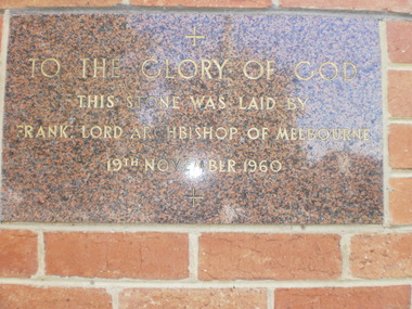 Glen Eira Historical Society
Document - Holy Nativity Church of England, Murrumbeena
Photocopied handwritten document by John O’Callaghan, giving church address and when and who foundation stone laid by unknown source Photocopied page from Feeding Christ Sheep, documenting gifts given in memory at St Peters Church and Holy Nativity Church. This is a book supplement from St. Peters Murrumbeena 75th Anniversary. All original documents are in File 1230 for St. Peters Churchholy nativity church of england, lord frank archbishop of melbourne, desaram dawn, cotes kath, murrumbeena., lord frank., desaram jack, willoby moya, blythe street, archbishop, desaram rochelle, sutherland les, poath road, st. peter’s, pereira lionel, sutherland mavis, foundation stones, gregson jack, gregson family, pereira jemima, sutherland noel, gregson sylvia, farrant brenda, farrant robert, farrant thelma, arliss stan, arliss irene, stehle siggy, mole lorna, mole jack, furnell lance, furnell bobbie, furnell alice, howard anne, howard family, howard john leslie, church furniture