Showing 3660 items
matching landscaping
-
 Friends of Ballarat Botanical Gardens History Group
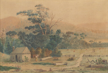
Work on paper - Ballarat Botanical Gardens Fernery, Brief for Landscape Design
Ballarat Botanical Gardens Fernery. Brief for Landscape Design.john garner collection, ballarat botanical gardens, fernery, design, landscape, gardens, ballarat -
 Bendigo Military Museum
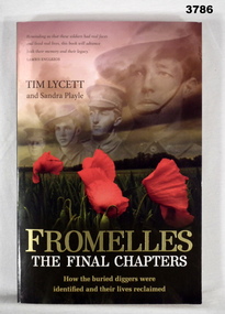
Book - BOOK WW1, Tim Lycett, Fromelles - The Final Chapters, 2013
Fromelles - The Final Chapters - How the buried diggers were identified and their lives reclaimed.Soft cardboard cover. Gold / white / black print on front, spine & back. Illustrated front to back, photos of field of poppies in landscape with 4 soldier's portraits in soft sepia tones in the sky of the landscape. 262 pages, cut, plain, off white. Between pages 134 - 135 are an illustrated collection of photos in black / white / colour / sepia on glossy white paper.book, fromelles -
 Glenelg Shire Council Cultural Collection
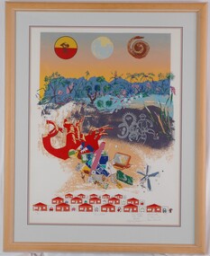
Print, Unentitled, 1987
UnknownPrint of a landscape scene in upper half of print. In a blue and orange sky are three roundels with (l-r): an indigenous soldier (c. WWII) overprinted with red and yellow, a depiction of the view of Earth from space, and a curled snake in reds and browns. In the landscape scene are line-drawn figures, a montage of items of modern technology and a child-like drawing of houses and cars in garages.Front: 26/30 (lower left) "Unentitled" (lower centre) Rex Davies Vicki Gordon Bruce Robert Peagram Maria Gibbs P. Tsernjavski Barb Sharrock (lower left) (pencil) Back: (no inscriptions) -
Tatura Irrigation & Wartime Camps Museum
Folder - biography, Gustav Pohlig, 27 June 1945
forwarded by Mr Gustav Pohlig: University exam results and on the back page addressed envelopes, Australian landscape and pastoral landscape, typical of the Christmas post cards mailed from Australia. Mailed from No 16 POW group in Marrinup WA to Germany.a clear plastic envelope with many pages written in German of Obergefreite Gustav Adolf Pohlig, geberen 6 November 1916. gustav pohlig -
 Eltham District Historical Society Inc
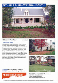
Folder, Landscape, 60 Lavender Park Road, Eltham South
Morrison Kleeman Real Estate sales information material relating to the property "Landscape". Built by the cartoonist and painter Percy Leason (1889-1959). anthropologist. Leason was associated with the Montsalvat Artists’ Colony and built “Landscape” before he moved to the USA in 1937 . 6 documents, 12 pages A4 gayle blackwood collection, houses, morrison kleeman real estate, eltham south, landscape, lavender park road, percy leason -
 Marysville & District Historical Society
Photograph (Item) - Black and white photograph, Nicholas John Caire, c1880-1884
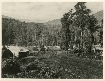
A copy of an early black and white photograph of Murchison Street in Marysville in Victoria taken by Nicholas John Caire.A copy of an early black and white photograph of Murchison Street in Marysville in Victoria taken by Nicholas John Caire. Murchison Street was named for Roderick Impey Murchison who was one of the most distinguished geologists of the 19th century. His liberality and social position plus the pride he took in his science were of immense value in furthering the cause of learning in Britain. Nicholas John Caire was born in 1837 in Guernsey. He arrived in Adelaide about 1860 along with his parents who encouraged his early interest in photography. He opened a studio in Adelaide in 1867 after traveling extensively throughout the Gippsland taking photographs. After marrying in 1870 he moved to Talbot in Victoria until 1876 when he opened a studio in the Royal Arcade in Melbourne. After 1885 Nicholas John Caire gave up his city work and made his home in South Yarra and devoted the rest of his life to outdoor photography, specializing in the bush, the gullies, and the mountains of south-eastern Victoria. LES HARSANT/ HEALESVILLE Entrance to Marysville/ from Nicholas Caire photo - c.1880-84 See Pitkethly, N.J. Caire, Landscape Photographer Pithkethly, Rosanna, Vic. 1988; plate 17murchison street, marysville, victoria, nicholas john caire, roderick impey murchison, geology, geologist -
 Latrobe Regional Gallery
Print, ORTON, Alison, Fossil Landscape 1999, 1999
Coloured LinocutSigned and dated 'A. ORTON 1999' in lower right corner under printed image. Titled 'Fossil Landscape' centred under print. Edition in lower left corner under printed image - illegible. -
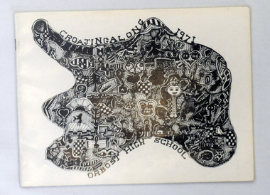 Orbost & District Historical Society
magazines, Croajingolong 1971, 1971
This is the twenty-fourth issue of the annual magazine of Orbost High School. The name Croajingolong derives from the Australian Aboriginal Krauatungalung words galung, meaning "belonging to" and kraua, meaning "east". 2219.1 belonged to Mary Gilbert, a former teacher at the school. 2219.2 belonged to Peter Traill.This magazine is a useful reference tool.Three copies of Croajingolong 1971. The magazine is in landscape format and has a white cover with a free form shape filled with mosaic type patterns in black and white. 2219.2 has Peter Trailll written in blue pen on the front cover.croajingolong orbost-high-school -
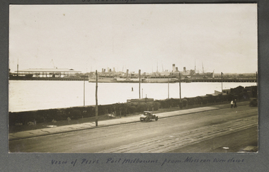 Mission to Seafarers Victoria
Photograph - Photograph, Sepia, View of Piers, Port Melbourne from Mission windows, Early 20th C
This image appears to have been taken from the second storey of the Mission to Seamen, on Beach Rd Esplanade, Port Melbourne circa 1912 - 1920. One of several images on loose album pages.An early image taken from the building established in Port Melbourne initially in the mid 19th C and operating up to the 1930s until replaced by a modern deco building in 1936. Shows examples of vintage cars.Small Landscape B and W image of ships moored alongside a pier in distance and small early car in foreground on unsealed road travelling left to right. Handwritten descriptive inscription is written underneath on an album page.port melbourne, mission to seamen building, port melbourne pier, fan album -
 Mission to Seafarers Victoria
Photograph - Photograph, Black and white, Reverend John Reginald Weller, The luncheon hour, c. 1925
Landscape black and white photograph with a thin white border depicting the front of the Mission on Flinders Street and showing how busy it can get with horse cartsHandwritten in white ink on the left: The luncheon hourweller album, weathervane, norla dome, horse carriage, flinders street, luncheon -
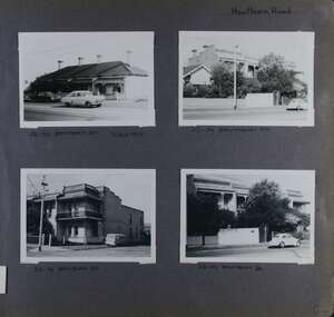 Glen Eira Historical Society
Album - Album page, Hawthorn Road, Circa 1972
This photograph is part of the Caulfield Historical Album 1972. This album was created in approximately 1972 as part of a project by the Caulfield Historical Society to assist in identifying buildings worthy of preservation. The album is related to a Survey the Caulfield Historical Society developed in collaboration with the National Trust of Australia (Victoria) and Caulfield City Council to identify historic buildings within the City of Caulfield that warranted the protection of a National Trust Classification. Principal photographer thought to be Trevor Hart, member of Caulfield Historical Society. Most photographs were taken between 1966-1972 with a small number of photographs being older and from unknown sources. All photographs are black and white except where stated, with 386 photographs over 198 pages. 23-29 Hawthorn Road Caulfield North are contributory buildings to HO14 Caulfield North and environs, Caulfield North - Heritage Precinct in the City of Glen Eira.Page 82 of Photograph Album with four landscape photographs of street views of two sets of properties on Hawthorn Road. Addresses are handwritten underneath each property.Handwritten: Hawthorn Road [top right] / 28-34 HAWTHORN ROAD 3 Sep 1972 [under top left photo] / 23-29 HAWTHORN ROAD [under top right photo] / 23-29 HAWTHORN ROAD 3 Sep [under bottom left photo] / 23-29 HAWTHORN ROAD [under bottom right photo] / 82 [bottom right] trevor hart, caulfield, hawthorn road, victorian, cars, terrace houses, cottages, streetscapes, caulfield north -
Federation University Historical Collection
Booklet - Report, Sturt Street Gardens, Ballarat, Victoria, Conservation and Landscape Management Plan, July 2007, 07/2007
The Sturt Street Gardens had its origins in the 1851 survey of Ballarat West by W.S. Urquhart. A generous reserve was allocated for the main streets of Ballarat, of which Sturt Street was the first. In the 1860s Sturt Street was planted with blue gums, with dual carriageway and central median Strip. Bandstands were soon erected.70 page report on the Ballarat Sturt Street gardens. The report includes an historical overview, Physical Analysis, Statement of Cultural Significance, and Consideration and Landscape Policies.queen alexandra bandstand, titanic memorial bandstand, sturt street, sturt street gardens, blue gum, statues, eight hour day memorial, boer war memorial, peter lalor statue, bluestone, bluestone guttering, william dunstan vc, time capsule, conservation management plan, landscape management plan -
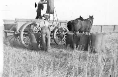 Churchill Island Heritage Farm
Photograph - Photograph of two men loading hessian sacks
Churchill Island has a significant photograph collection dating from the nineteenth century.Black and white landscape photograph of two men loading/offloading full hessian sacks onto a four wheeled cart being pulled by two horses.churchill island -
Port Melbourne Historical & Preservation Society
Photograph - Perce White Reserve, Port Melbourne, 1990s
Three photos, origin unknown, of Perce White Reserve. .01 - (landscape) .02 - (portrait) open view into bush .03 - (portrait) dark path into bushNumbers in green on back 22, 23, 20parks and gardens, environment, friends of port melbourne foreshore, perce white reserve, perce mcguire white, perce white -
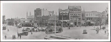 Bendigo Historical Society Inc.
Photograph - B&W photograph of the intersection of Pall Mall, View & Mitchell Streets, Bendigo, early 1900s
Early 1900s streetscape of major intersection in Bendigo Landscape format. B&W photograph of the intersection of Pall Mall, View & Mitchell Streets, Bendigo, early 1900s. Three electric trams, cars and pedestrians social history -
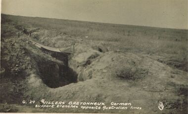 Bendigo Historical Society Inc.
Postcard - ACC LOCK COLLECTION: VILLERS BRETONNEUX GERMAN SUPPORT TRENCHES OPPOSITE AUSTRALIAN LINES, POSTCARD, 1914-1918
Postcard, WW1, B&W image of German support trenches at Villers Bretonneux opposite the Australian Lines. Desolate landscape in background. Copy G 29postcard, postcard, ww1, france, villers bretonneux -
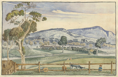 Benalla Art Gallery
Watercolour, Elizabeth PARSONS, Cameron's Station, Pyrenees, c. 1890
Born: Isleworth, Middlesex, England 1831; Arrived: Melbourne, Victoria, Australia 1870; Died: Melbourne, Victoria, Australia 1897VictorianGift of Mrs E.E. Ledger, 1982Rural landscape with house, fences, trees hills, a creek and a small figure carrying a fishing line. Thin, dark blue grey brushed timber frame.Recto: Signed "PARSONS" in black watercolour in l.l.c of composition; Not dated; Not titledwatercolour, landscape, tree, mountains, animals, cows, figures, fence, creek, colonial, buildings -
 Benalla Art Gallery
Watercolour, H. L. VAN DEN HOUTEN, Settler's hut, Not dated
Born: The Hague, Netherlands 1801; Arrived: Melbourne, Victoria, Australia 1853; Died: Melbourne, Victoria, Australia 1879ColonialGift of Mrs E.E. Ledger, 1987Watercolour depicting a rural landscape with a settler's hut and figures standing in a cleared paddock. Gold and grey brushed timber frame with off white window mountRecto: Signed "H L Van den Houten" in brown watercolour in l.r.c of composition; Not dated; Not titledwatercolour, landscape, house, figures, path, fence, building, hills -
University of Melbourne, Burnley Campus Archives
Book - Student Records, Landscape Design Course 1977, 1977
Table of student names and dates of attendance dated 07/02 1977-24/10 1977. From file marked: Landscape Design Course 1977.students, attendance, 1977, landscape design course -
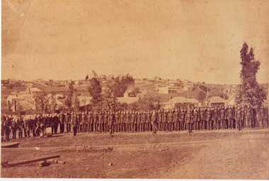 Clunes Museum
Photograph, 1868
.1 SEPIA PHOTOGRAPH AND POSTCARD OF CLUNES DETACHMENT CRESWICK VOLUNTEER RIFLE. CLUNES LANDSCAPE IN BACKGROUND. .2 POSTCARD SIZE BLACK AND WHITE IMAGE OF THE ABOVEMrs? C Wilkinson, Station Flat, Clunes The photo was taken in 1868, find your uncle and fatherlocal history, photographs, volunteer rifle detachment -
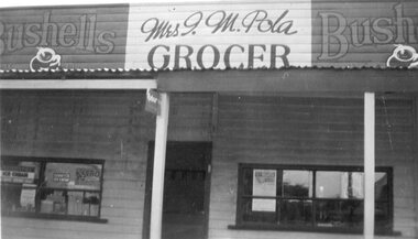 Stawell Historical Society Inc
Photograph - Shop Front, Mrs I.M. Pola - Grocer
Stawell BusinessB/W Landscape - Shop front of Mrs I.M Pola advertisments in window Bushells ads eithe rside of propietors name. weatherboard with iron roof Bushells Mrs I.M. Pola Bushells Grocer On Rear written in blue: Front view of shop 117 Patrick Street Stawell, Owned by Mr T May. Then by Mr P.A. Pola, left in will to mrs I.A. Pola in 1945stawell shops businesses streetscape -
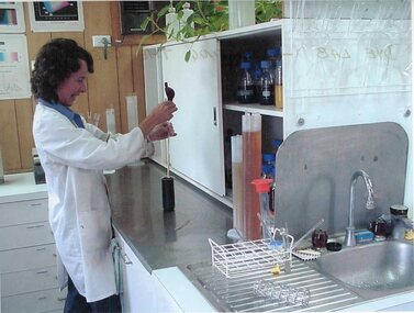 Stawell Historical Society Inc
Photograph - Aunde Album 29, Dye Lab - Creating the Dye Mix, 2002
Aunde / Norwellan Textiles North Western Woolen Mills became Norwellan Textiles then AUNDEColour landscape photo: Dyer in lab coat using glassware to mix dye. Open cupboard with dyes Glassware racked above sink, glassware drainingAUnde Australia Ltd. logoindustry, aunde -
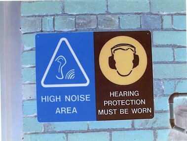 Stawell Historical Society Inc
Photograph - Aunde Album 29, Safety Signs, 2002
Aunde / Norwellan Textiles North Western Woolen Mills became Norwellan Textiles then AUNDEColour landscape photo: Blue brick wall with (2) Two signs Blue White triangle. Ear with Sound waves. Brown head with Hearing protection1 - High Noise Area 2 - Hearing Protection must be wornindustry, aunde -
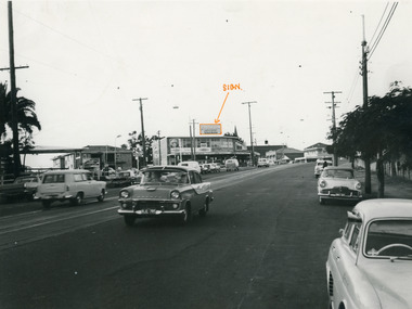 National Wool Museum
Photograph, Collins Bros Mill Pty Ltd, Physician Blanket Road Sign, Unknown
Advertising sign for the Physician Blankets Manufactured by Collins Bros Pty Ltd. Black and white photograph showcasing the Physician Blanket advertising road sign above a two story building in a landscape format. The road and moving cars are in the foreground.Front centre - Physician Chillproof Blankets. Sign Rear - Physician Brisbane (?) (?) Signwool, woollen mills, wool manufacture -
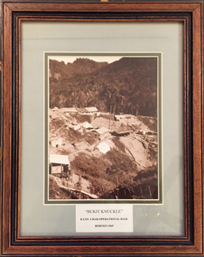 Tramways/East Melbourne RSL Sub Branch - RSL Victoria Listing id: 27511
Picture, Bukit Knuckle
Framed print of a sepia photograph showing the camp at 'Bukit Knuckle', an operational base of the 3RAR in Borneo. Images shows an aerial view of the camp and surrounding landscape. Underneath the print is added 'BUKIT KNUCKLE' B COV 3RAR OPERATIONAL BASE, BORNEO 1965 On reverse is marked 'Donated by Keith Matthews 1995'bukit knuckle, sungei koemba, 3 rar, indonesia malaysia confrontation -
University of Melbourne, Burnley Campus Archives
Document - Student Work, Jamie Sweetman, Assignment 1: Landscape Construction Portfolio, 2017
landscape design, construction, assignment, student work -
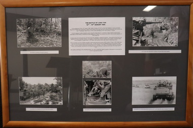 Diamond Valley Vietnam Veterans Sub-Branch
Memorabilia - Long Tan, 2/11/2020
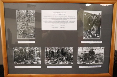
The collage represents different elements of the Battle of Long Tan.The Battle of Long Tan is generally recognised as Australia's major battle in the Vietnam War; the the lingering memory and conclusive evidence of the courage of the soldiers in the battle holds great reverence amongst Vietnam veterans.Framed presentation of Long Tan story with 6 panels - 1 x text and 5 x photos - 4 x landscape, 1 x portraitText panel is a brief introduction of Long Tan story; 5 photos have short descriptive text.vietnam, vietnam war, battle of long tan, diamond valley vietnam veterans sub branch -
 Diamond Valley Vietnam Veterans Sub-Branch
Memorabilia - Long Tan, c2020
Item has pictures of Long Tan and includes text describing in brief The Battle of Long Tan.The Battle of Long Tan is generally recognised as Australia's major battle in the Vietnam War; the the lingering memory and conclusive evidence of the courage of the soldiers in the battle holds great reverence amongst Vietnam veterans.Framed Presentation of the Long Tan story with 6 panels - 1 x text and 5 x photos - 2 x portrait, 3 x landscapeText panel continues a brief introduction to the Long Tan story; 5 photos have short descriptive textvietnam, vietnam war, battle of long tan, diamond valley vietnam veterans sub branch -
 Bendigo Historical Society Inc.
Postcard - Alice McGregor Postcard Collection, 1900 - 1920
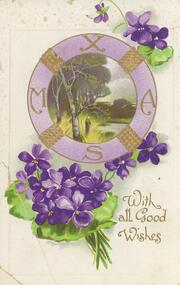
Alice McGREGOR Born: 1908; unknown parents. Possibly adopted by the Salter family? Electoral Roll 1936: Highland Terrace Kangaroo Flat. Alice Mary Salter and William Robert Salter living together; presumed to be sister and brother. William Robert Salter was killed in a MVA in Bendigo in 1937 aged 26. In Victoria in 1938, Alice Mary Salter married James Thomas McGregor (born Victoria 1917, died Victoria 1983, buried Fawkner Cemetery) Lived: 1968; 22 Wade Street Golden Square Alice McGregor Died: 1999 aged 91 at Anne Caudle Centre, Bendigo Buried: Kangaroo Flat Cemetery See additional research. Postcard Album of Alice McGregor contained 86 post cards.Postcard Album of Alice McGregor contained 86 post cards. See 1400. Purple violets surrounding a painted landscape scene surrounded by letters XMAS. Addressed to Miss Shatford from Jessie Simpson. Dated 22/12/08.postcard, collector, alice mcgregor -
 Stawell Historical Society Inc
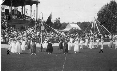
Photograph, Dancing the May Pole in Central Park
Huttley - Martin FamilyB/W Landscape: At Central PARK. Students dancing the May Poe watched by crowd. 1 Pole for Girls 1 Pole for Boys, in sailor suitsPostcard Correspondence Address only Kodak Madge and ray Huttley Stawell huttley, martin