Showing 2592 items
matching parts of buildings or structures
-
 RMIT Design Archives
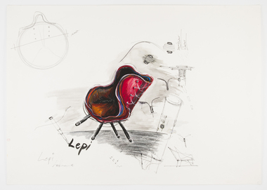
Work on paper - Design drawings, Sketch of Lepidoptera Chair or 'Lepi' winner of the 2009 Cecily and Colin Rigg Contemporary Design Award
The name of this chair, Lepidoptera, refers to the insect species of moths and butterflies as LeAmon drew upon the anatomy of a butterfly to develop the concept of the chair?s structure, colour and pattern. Another key feature of the design was the use of textile remnants from automotive textile manufacturer Autofab,recalling LeAmon's redeployment of leather offcuts from the manufacture of cricket balls to make her 'Bowling Arm' series of bangles.industrial design, furniture -
 Lakes Entrance Historical Society
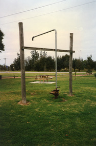
Photograph, 1999
In late 1958 bore put down in an attempt to obtain good quality water for a reticulated town water supply. Water unsuitable, but during drought years when water supply from Nicholson River was restricted, water from this bore available for public use. Bore plugged, structure removed December 2000. Site marked with plaque March 2001, by Lakes Entrance Historical Society.Colour photograph of the head works including feed pipe of water bore sunk in late 1958 on the Public Reserve bound by Marine Parade and the highway approach to North Arm Bridge, Lakes Entrance, Victoria.water supply, public utilities -
 Sunbury Family History and Heritage Society Inc.
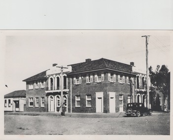
Photograph, The Royal Hotel, c1939
The two storey building is the Royal Hotel which is sited on the corner of Brook and Evans Streets in Sunbury's main shopping strip.The photograph was taken sometime in 1939 after it was totally rebuilt. A fire had damaged the old single storey structure, which was built on the same site c1860 shortly after Sunbury had a rail service. The building still operates today on the same site.The Royal Hotel is one of four hotels that were built in Evans Street Sunbury between Brook and Station Streets ion the 1860s shortly after the rail service arrived in the town. They were They were the Railway Hotel (Olive Tree), White Horse Hotel, Royal Hotel and the Rupertswood Hotel, opposite the Royal Hotel. A non-digital black and white photograph with a cream border of a two storey brick hotel building with light concrete trimming around the windows and entrances sited on a corner. A large black sedan car is parked near the corner. royal hotel, hotels -
 NMIT (Northern Melbourne Institute of TAFE)
Book: TAFE colleges management study: report to the Chairman of the TAFE Board, Victoria 1985
Report of 302 pages, published in March 1985 by Cullen Egan Dell Australia Pty. Ltd. ISBN 0724126554. The study was conducted to examine organisational requirements for the TAFE college system in Victoria. Conclusions and recommendations are included. The project team was asked to provide: a rationale for the organisation of TAFE colleges; a number of detailed structures and arrangements; a comprehensive position specification for the chief executive of a TAFE college; comprehensive position specifications for senior management positions in TAFE colleges; identification of organisational relationship issues and proposals to address them; and strategies for the implementation of organisation proposals. The team examines in detalis the arrangements within six TAFE colleges selected to provide a representative sample of the total network in Victoria. Although many positive features of TAFE in Victoria were noted, the team concluded that significant problems existed in the system at this time and that these impair the capacity of TAFE to operate in a fully efficient and effective way. A range of strategies are proposed to address these concerns along with new management structures and arrangements for colleges designed to meet the current and future needs of the community more effectively.tafe board victoria, nmit -
 The Beechworth Burke Museum
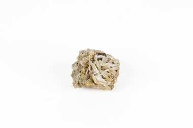
Geological specimen - Cerussite, Unknown c.1890s
Named in 1845 by Wilhelm Karl von Haidinger cerussite takes its name from the Latin cerussa, meaning 'white lead'. When viewed under certain lighting conditions cerussite gives of fire and rainbow-like colours (due to its high dispersion) and it is quite sought after by geological collectors for this very reason. Cerussite is usually found in the oxidised zone of lead ore deposits. It is a very common weathering product of galena and other lead ore minerals. It is a secondary mineral, meaning it forms as a result of the alteration of pre-existing minerals in the Earth’s crust. The presence of lead in cerussite makes it potentially toxic. Historically, it has been an important source of lead, which has numerous industrial applications, including in batteries, construction materials, and radiation shielding. Cerussite has a crystal structure that belongs to the orthorhombic crystal system. Its crystal structure is characterized by a three-dimensional arrangement of atoms in a repeating pattern. The crystal lattice of cerussite consists of interconnected lead (Pb) and carbonate (CO3) ions. This crystal structure is visible in the specimen. This specimen was found in Dundas (formerly Mount Dundas), a historical mining locality, mineral field and railway located on the western foothills of the West Coast Range in Western Tasmania. During the 1890s Dundas swelled in numbers however it is now lost in a temperate rainforest and its population is now 2. The present Dundas Extended mine, about 1.5 km east of Dundas is presently worked for specimen material.Faceted cerussite gems are considered rare and valuable, given the softness of the mineral. This item is not a faceted gem however its historical and scientific research potential give it significance; mined in an Australian township, this cerussite could shed light on the now lost history of Dundas and the mining that occurred there. Additionally, the uses of this mineral in historical industrial processes give it scientific significance. Such knowledge can add to understandings of the geographical and geological nature of Western Tasmania and allow for further study of Australian geological specimens. A small lead carbonite mineral with shades of cream, white and brown throughout, flaky shards of white at base. CERUSSITE / (lead carbonite) / Locality: Dundas, W. Tasmaniadundas, tasmania, cerussite, lead, orthorhombic, geology, minerals, mining -
 The Beechworth Burke Museum
Postcard, George Symons, c.1990
The photograph printed on this postcard comes from the collection of the Mitchell Library in Sydney. It is sepia in tone and depicts seven men standing and sitting around a mine shaft in the Beechworth region. The photograph has been dated to approximately 1872. This period in history post-dates the Victorian gold rushes which occurred 1852-1853 in Ballarat, Bendigo and Beechworth. During this period, in the 1870s, the surface alluvial gold had been discovered and removed from location. Therefore, in order to reach the deeper and less accessible alluvial gold, diggers began to dig shafts into the earth. These shafts sunk below the ground level by 20 to 30 feet and required timber structures around the entrance and winches to bring the paydirt to the top. The top of this wooden structure is visible behind the man standing in the upper right of the image. This type of mining was highly dangerous as mines often caved in which injured the minors and often resulted in death. Thus, following this period, in the early 1900s, miners opted instead for hydrolic slucing which cut away the earth without the devastating consequences of a mine cave in. This particular group of miners appear to have been unable to afford a horse (then worth around 50 pounds) which were generally used at mines like this to help pull buckets attached to ropes up and down the mine. Instead, this group brought the buckets up and down by windlass. The windlass was a wooden structure mounted over the mining shaft and fitted with a hand-cranked winch which enabled the bucket attached to the rope to be brought up and down.Gold was first discovered in Beechworth in Spring and Reid's Creek in the summer of 1852-1853. At its popularity, this region had approximately 8000 people on the gold fields searching for gold on the banks of these creeks. These periods did not require the use of heavy machinery or the digging of deep mining shafts like the one depicted in this image. Therefore, this image has important connotations for the technologies associated with mining during the approximated 1870s when gold was harder to access. This is a later period in gold history which does not fit into the "gold rush" period. Instead, it occurred after the surface gold had disappeared and therefore, is essential for researchers who are investigating the mining techniques and structures used to reach the alluvial gold which was located deeper under ground in the 1870s. This period predates the use of big heavy machinery used to mine in the 1900s which include dredges. Images such as this one can also impart essential information as to the wardrobe and fashion of men during this period. It also imparts knowledge about the landscape of Beechworth which is useful for people researching the environment and impact of gold mining in the north-east region of Victoria. In addition, since this image is a postcard reproduction of an early Australian image which may date to approximately 1990 it can impart knowledge as to the interests of people during this time period when there may have been an increase into Australian history.A sepia tone facsimile of an early Australian photograph (circa 1872) printed as a postcard.Obverse: BEECHWORTH / Victoria, Australia / Reverse: GM 2 3275 / CORRESPONDENCE / AUSTRALIAN / YESTERYEAR / CARDS / ADDRESS / Published by George Symons (057) 65 3240 / THE MINEHEAD C. 1872 / The easily gleaned gold of the early fields did / not last very long. In order to reach less / accessible alluvial gold diggers began sinking shafts as much as twenty to thirty feet down / and the mines required timbering and winches / to bring the paydirt to the top. / This syndicate has been unable to afford the / luxury of a horse (about 50 pounds) and so everything / must go up and down by windlass and rawhide / bucket. / Photo: Mitchell Library, Sydney / A sepia tone facsimile of / an early Australian photographmining album, gold mine, beechworth, burke museum, mine shaft, postcard, australian yesteryear cards, george symons, the minehead, gold fields, alluvial gold, early australia, c.1872, 1872, gold diggers, north east victoria -
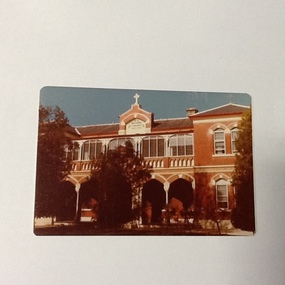 Port of Echuca
Colour Photograph, Approx. 1979
Formerly the home of Henry Hopwood. Apsley House, No. 1 Echuca. This was purchased for the Bridgine nuns to establish a catholic co-education school in Echuca. Extensions were made to the original structure (to the south of this building) with outbuildings and brick stables converted to school rooms during the late 1886 and opened as St Joseph's in 1887. The front section of the school was built in 1888. At the time of this photograph the upper floor of the building was the boarding house. The school building holds historical, social and spiritual significance to Echuca being the former home of Echuca's founder, Henry Hopwood. The diocese purchased the original building for 1,000 pounds. The school opened as a co-educational school on 22/3/1886 with 16 boys and 7 girls. It's first enrolment was a non-Catholic boy. By the end of 1886 there were 30 pupils. The boarding school opened on 4/5/1886 with 6 students. The chapel (to the north of this building) was built in 1889. For 60 years the school provided both primary and secondary schooling but in 1960's it changed to secondary schooling. The boarding house closed around 1986 and the school continued as a co-educational catholic college.Colour photograph (post-card size) of Bridgine Convent, Echuca (St.Joseph's College), showing arched facade over the verandah and the upper louvred windows of the boarding house.On front above the entrance "Brigidine Convent A.D. 1886.. Printed on the reverse:" this paper manufactured by Kodak"echuca- secondary schools, st joseph's college, echuca, brigidine convent, echuca -
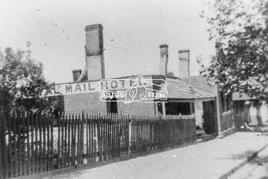 Eltham District Historical Society Inc
Photograph, Royal Mail Hotel, Diamond Creek; destroyed by fire, 1925
This hotel was located in Chute Street Diamond Creek. The site was from the C.F.A. station east to the corner. In 1925 this hotel was burnt down at 11.00 am on a week day and the street was closed by police because the lighting system used petrol gas and an explosion was feared. Fortunately there was no explosion. This photo shows the gutted structure after the fire. Yarra Plenty Regional Library https://yprl.bibliocommons.com/item/show/485980027_royal_mail_hotel,_diamond_creekBlack and white copy of photo printed on glossy photographic paper 30.5 x 40.5 cm (12 x 16 inch); image size approx. 18.5 x 28 cmchute street, diamond creek, fire damage - buildings, royal mail hotel -
 Eltham District Historical Society Inc
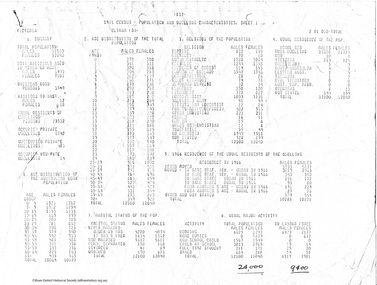
Document - Folder, Census information, 1983
Report of population and dwelling characteristics from the 1971 Census relating to the Shire of Eltham. Comparative population statistics about the Shire of Eltham, August 1983. Historical population growth for the Shire of Eltham 1871-1981 Comparison of 1976 and 1981 populations by age group, population by urban area, age structure, number of dwellings, family type, households and more Part of Folder 75 from Harry Gilham Collection 4 A4 pages (photocopies), 2 printed A4 pages and 2 printed maps (A3) folded. 5 pages headed September, 1983population, statistics, census, shire of eltham -
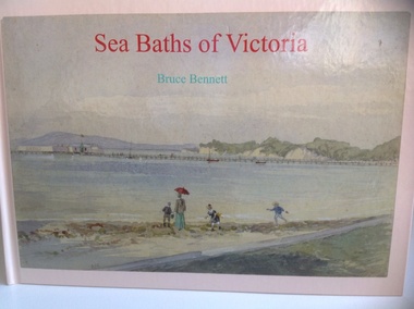 Warrnambool and District Historical Society Inc.
Book, Sea Baths of Victoria, 2013
History of sea baths in Victoria.Hardback, landscape book with watercolour painting of Sea baths at Sorrento looking east by AC Clarke on the front. Also the title in red and author Bruce Bennett in aqua. The spine has the title and author as above. On the back cover are six reproductions of sea baths and synopsis of the book. 152 pages of white, gloss paper, acknowledgements, contents, preface, 5pages of References and a 2 page Index. The end papers are of white paper. non-fictionHistory of sea baths in Victoria.sea water baths, victoria, bruce bennett, warrnambool, windmill, 1890, swimming, closed 1960s, bathing boxes, poster, warrnambool baths company, 1877 -
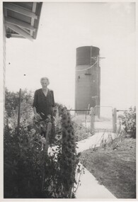 Rutherglen Historical Society
Images, 1960s
One of a collection of photographs from the Iggsten Estate. The water tower in the background is located in Hunter Street and was built in 1899-1900 to serve as the town's water supply. A new reservoir was built in 1945 with water being pumped from the Murray. A steel mesh structure, to make it look like a wine bottle, was added to the top in 1969 with funds from the Rutherglen Wine Festival. The woman in the photograph may be Florence Iggsten. Black and white photograph of a woman standing in a front garden, with a view of a water tower in the background.florence iggsten, water tower, wine bottle, tourism -
Unions Ballarat
Ledger. Political Labor Council of Victoria, Ballarat Branch, March 1911-August 1912
The ledger is part of the financial recordkeeping of the Political Labor Council of Victoria, Ballarat Branch. Constitution of the Political Labor Council of Victoria can be found at http://tinyurl.com/politicallabourcouncilvic. It had platforms at federal, state and municipal levels. The state platform includes land policy, financial policy including restriction of public borrowing, reform of parliamentary structure, industrial regulation, free education, support for technical education and adequate pensions.Constitutes part of the history of the Political Labor Council of Victoria. Financial transactions. Paper ledger - one volume.political labor council of victoria - ballarat branch, btlc, ballarat regional trades and labour council, finance - record keeping -
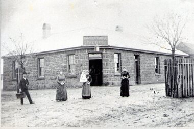 Sunbury Family History and Heritage Society Inc.
Photograph, Ball Court Hotel
The hotel was built some time shortly after 1842 by John Cahill, who arrived in the colony in 1842 from Thurles in Tipperary, Ireland. The building although much altered with render covering the original \blue stone structure is on the south-west corner of Macedon and Jackson Streets. The hotel was called the Ball Court because Cahill also had a hand-ball court set up behind the hotel.Originally five hotels were built along Macedon Street between Jackson Creek and Evans Street. The Ball Court Hotel is the only one still standing and operating as a hotel.A non-digital black and white photograph with a cream border of man and three ladies standing outside a single story blue stone hotel building with a corner entrance. AS well as the corner entrance there is another doorway on the RHS along with three narrow windows and three other windows on the other side. One of the ladies is holding a little child. Two trees surrounded by tree guards are on each side of the photograph.Ball Court Hotel, John Cahillball court hotel, hotels, sunbury, macedon street, jackson street, ball court -
 Surrey Hills Historical Society Collection
Book, Museums and their visitors, 1994
Museums are changing from being static storehouses for artefacts into active learning environments for people. New forms of museums, new ways of working with objects, new attitudes to exhibitions and above all, new ways of relating to museum publics, are emerging. At the end of the twentieth century, old structures are being replaced to prepare for a new century. Many social institutions are reviewing their roles and potentials, and museums and galleries are among them.incl. bibliographical references; 213p; endpaper: Susan Barnett museums -
![Painting - Artwork, Rodney Forbes et al, [Printery], c1982](/media/collectors/530576742162ef0fa09a2288/items/57ecace9d0cdd12be41850de/item-media/57ecad44d0cdd12be4188585/item-fit-380x285.jpg) Federation University Art Collection
Federation University Art CollectionPainting - Artwork, Rodney Forbes et al, [Printery], c1982
Rodney FORBES (1951- ) Born Melbourne Rodney Forbes' work is figurative narrative painting and uses autobiographical and incident-as-metaphor methods to explore wider issues of knowing and belonging in oral traditions such as working class, children’s and artisan subcultures. His practice draws on pop, cartooning and joke narrative structures within contemporary culture. (http://www.australiangalleries.com.au/artists/rodney-forbes/, accessed 07 April 2017)A large painting showing aspects of a printery. Rodney Forbes and fellow student Linda Karklins worked on this painting as an undergraduate student at the Gippsland School of Art (Gippsland Institute of Advanced Education, now the Gippsland Centre for Art and Design, Federation University Gippsland Campus). The painting hung for many years in the campus printery. The Gippsland Gippsland Centre for Art and Design is now part of Federation University Gippsland Campus.rodney forbes, printery, gippsland campus, churchill, linda karklins, gippsland school of art, gippsland institute of advanced education, printing -
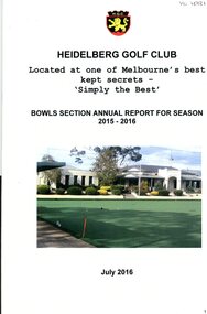 Heidelberg Golf Club
Booklet - Annual Report, Heidelberg Golf Club Bowling Club, Heidelberg Golf Bowling Club: Annual Report for season 2015-2016, July 2016
Heidelberg Golf Bowling Club: Annual Report for season 2015-2016. Note change of title: "Heidelberg Golf Club. Bowls section annual report for season 2015-2016". The integration of the Bowling Club into the management structure of the Golf Club took place during this year. The Bowling Club was formed in 1958 to enable members no longer able to walk the hills of the golf course to have a sporting involvement with the club.Annual reports found in this collection begin in 1959-60. Numbering of Annual Reports begins with the Eighth report in 1965-66.16 pages, stapled. Typed and copied report. 2 copiesannual reports, financial reports, heidelberg golf club bowling club -
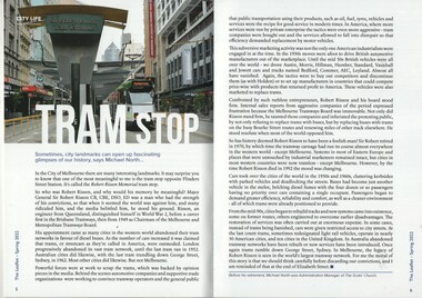 Melbourne Tram Museum
Book - The Scots Church - The Leaflet Spring 2022, Michael North - Scots Church, "Tram Stop", Sept 2022
Tram Stop article written by Michael North looks at the structure at the Elizabeth St tram terminus, named after Sir Robert Risson and his convictions to support the Melbourne tramway system including the campaigns to replace Melbourne's iconic trams with buses and motor cars. Has a photo of the terminal building by Mal Rowe - Sir Robert Risson Tram Terminus. The rear cover image of La Trobe St.Yields information about the Elizabeth St tram terminus and its memorial to Sir Robert Risson, MMTB Chairman 1949 to 1970,Book - magazine - 48 pages, perfect bound, full colour titled The Scots Church - The Leaflet Spring 2022 containing an article on the Robert Risson Tram Stop at the Elizabeth St tram terminus.trams, tramways, robert risson, elizabeth street, memorials -
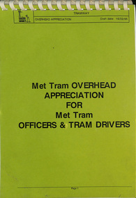 Melbourne Tram Museum
Document, The Met, "Overhead Appreciation - draft", 2/1995
Document - full title "Met Tram Overhead appreciation for Met Tram Officers & Tram Drivers" Gives a detailed inforamation on the structure of the tram overhead, its parts, poles, such as frog pans, crossing pans, points, contactors ,broken trolley wire, pantograph operation and feeder cables. Has notes on the SCADA system and Carlton Electrical control system. Written at the time when trolley poles remained in operation.Yields information about the Melbourne tramway overhead system.Document 47 A4 pages, clear plastic cover, with card covers comb bound along top edge.tramways, tramcars, equipment, overhead, electrical engineering, trolley wire -
Unions Ballarat
Book - Politics in Australia (3rd ed.), Smith, Rodney
Structure of Australian politics and parliamentary process and associated issues. Chapter titles: Introduction: Using this book and finding other resources on Australian politics / Rodney Smith 1. The nature of politics / Helen Pringle 2. Power / Rodney Smith 3. Democratic theory and practice / Michael Jackson 4. Public policy-making / Martin Laffin 5. Australian political thought / Ian Cook 6. The Constitution / Elaine Thompson 7. Parliament / Marcus Haward 8. Cabinet / Barbara Page 9. The public service / Elaine Thompson 10. The party system / Rodney Smith 11. Elections / Martin Painter 12. Federalism / Martin Painter 13. State politics / Helen Nelson 14. The structures of inequality / Michael Hogan 15. Gender and patriarchy / Vanessa Farrer 16. Interest groups / Trevor Matthews 17. Business and politics / John Ravenhill 18. Trade unions / Marian Simms 19. The news media / Rodney Smith 20. The Australian voters / Ernie ChaplesRelevant to democracy, politics and the trade union movement in Australia.Book; paper.Cover: editor's name and title. Cover page: in blue ink, "David Cadby". (Includes postal address and telephone number.)btlc, ballarat trades and labour council, politics and government, trade unions -
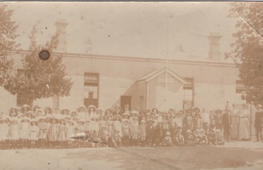 Sunbury Family History and Heritage Society Inc.
Photograph, Sunbury State School
The first building which housed Sunbury State School No.1002 was built on the corner of Macedon and Stawell Streets in the early 1870s and functioned as the local State School until 1912 when a sturdier red brick structure replaced on the same site. In 1999 Sunbury State School was relocated in the former Industrial School heritage buildings in Jacksons Hill. The existing building in Macedon Street was incorporated into the Sunbury Community Health Centre. The school in the photograph is the original Sunbury State School NO. 1002 building, where many early Sunbury residents attended. A non-digital black and white photograph in post card format of a crowd of children outside a school building. Four teachers are standing on the RHS of the image.sunbury state school no. 1002, stawell street, macedon street, schools -
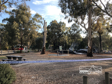 Eltham District Historical Society Inc
Photograph, Vicki Ward, Day breaks over the destroyed Adventure Playground at Eltham North, 16 December 2017
A community group project steered by Bambi McLean led to the construction of the Eltham North Adventure Playground which opened off Wattletree Road in 1995. The structure was mainly wooden and included an undercover element with slides and areas to climb. It was destroyed by fire in the early hours of 16 December 2017. These phtoos of the aftermath were taken at approx. 6:45am in the morning by Vicki Ward, MP for Eltham A new adventure playground was built in 2018. Digital fileeltham north, north eltham adventure playground, arson, wattletree road -
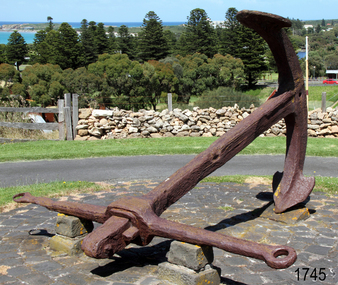 Flagstaff Hill Maritime Museum and Village
Equipment - Anchor, Circa 1886
The anchor is one of four that were carried by the FALLS OF HALLADALE when she was wrecked near Peterborough in 1908. This Rodger’s Anchor was raised from the wreck site by Flagstaff Hill divers (Peter Ronald, Colin Goodall and Gary Hayden) in 1974 and is on permanent outdoor display at the Maritime Village. The imposing 2-tonne artefact required a raft of fourteen 44-gallon drums to raise it from the seabed before it was towed by a crayfish boat to the wharf crane at Port Campbell for loading onto land transport. Following Lieutenant William Rodger’s patent in 1831, anchor design moved away from the separate attachment of straight arms and flat flutes to each side of a long shaft. Rodger’s innovation included the forging of both arms and their flutes as a single uniformly curved piece which was then attached to the crown of the shank by a thick horizontal bolt. The two-inch diameter hole for the securing through-bolt at the crown is clearly visible in this example, the bolt dislodged by corrosion and now missing. The FALLS OF HALLADALE was a four-masted, iron-hulled barque, built by Russell and Co at Greenock in 1866 for the Falls Line of Wright & Breakenridge, Glasgow. The ship was 275 feet long, 42 feet wide, with a 24 feet draft and weighed 2,085 tonnes. She was built to carry as much cargo as possible rather than for speed. Her unmistakably square bilge earned her the title of “warehouse-type” ship and her iron masts and wire rigging enabled her to maintain full sail even in gale conditions. In 1908, with new sails, 29 crew, and 2800 tons of cargo in her hold, the FALLS OF HALLADALE left New York, bound for Melbourne and Sydney via the Cape of Good Hope. 102 days later, at 3 am on the 14th of November, under full sail and in calm seas, with a six knots breeze behind and a misleading fog along the coast, the great vessel rose upon an ocean swell and settled on top of a shelf of rock near Peterborough. There she stayed for nearly two months until the pounding seas and dynamiting by salvagers finally broke her back, and her remains disappeared back into deeper water. The iron-hulled, four-masted barque, the Falls of Halladale, was a bulk carrier of general cargo. She left New York in August 1908 on her way to Melbourne and Sydney. In her hold, along with 56,763 tiles of unusual beautiful green American slates (roofing tiles), 5,673 coils of barbed wire, 600 stoves, 500 sewing machines, 6500 gallons of oil, 14400 gallons of benzene, and many other manufactured items, were 117 cases of crockery and glassware. Three months later and close to her destination, a navigational error caused the Falls of Halladale to be wrecked on a reef off the Peterborough headland at 3 am on the morning of the 15th of November, 1908. The captain and 29 crew members all survived, but her valuable cargo was lost, despite two salvage attempts in 1908-09 and 1910. ABOUT THE ‘FALLS OF HALLADALE’ (1886 - 1908) Built: in1886 by Russell & Co., Greenock shipyards, River Clyde, Scotland, UK. The company was founded in 1870 (or 1873) as a partnership between Joseph Russell (1834-1917), Anderson Rodger and William Todd Lithgow. During the period 1882-92 Russell & Co., standardised designs, which sped up their building process so much that they were able to build 271 ships over that time. In 1886 they introduced a 3000-ton class of sailing vessel with auxiliary engines and brace halyard winches. In 1890 they broke the world output record. Owner: Falls Line, Wright, Breakenridge & Co, 111 Union Street, Glasgow, Scotland. Configuration: Four-masted sailing ship; iron-hulled barque; iron masts, wire rigging, fore & aft lifting bridges. Size: Length 83.87m x Breadth 12.6m x Depth 7.23m, Gross tonnage 2085 ton Wrecked: the night of 14th November 1908, Curdies Inlet, Peterborough south west Victoria Crew: 29 The Falls of Halladale was a four-masted sailing ship built in 1886 in Glasgow, Scotland, for the long-distance cargo trade and was mostly used for the Pacific grain trade. She was owned by Wright, Breakenridge & Co of Glasgow and was one of several Falls Line ships, all of which were named after waterfalls in Scotland. The lines flag was of red, blue and white vertical stripes. The Falls of Halladale had a sturdy construction built to carry maximum cargo and able to maintain full sail in heavy gales, one of the last of the ‘windjammers’ that sailed the Trade Route. She and her sister ship, the Falls of Garry, were the first ships in the world to include fore and aft lifting bridges. Previous to this, heavily loaded vessels could have heavy seas break along the full length of the deck, causing serious injury or even death to those on deck. The new, raised catwalk-type decking allowed the crew to move above the deck in stormy conditions. This idea is still used today on the most modern tankers and cargo vessels and has proved to be an important step forward in the safety of men at sea. On 4th August 1908, with new sails, 29 crew, and 2800 tons of cargo, the Falls of Halladale left New York, bound for Melbourne and Sydney via the Cape of Good Hope. The cargo on board was valued at £35,000 and included 56,763 tiles of American slate roofing tiles (roof slates), 5,673 coils of barbed wire, 600 stoves, 500 sewing machines, 6,500 gallons of oil, 14,400 gallons of benzene, plumbing iron, 117 cases of crockery and glassware and many other manufactured items. The Falls of Halladale had been at sail for 102 days when, at 3 am on the night of 14th November 1908, under full sail in calm seas with a six knots breeze behind and misleading fog along the coast, the great vessel rose upon an ocean swell and settled on top of a submerged reef near Peterborough on the south-west Victoria’s coast. The ship was jammed on the rocks and began filling with water. The crew launched the two lifeboats and all 29 crew landed safely on the beach over 4 miles away at the Bay of Islands. The postmistress at Peterborough, who kept a watch for vessels in distress, saw the stranding and sent out an alert to the local people. A rescue party went to the aid of the sailors and the Port Campbell rocket crew was dispatched, but the crew had all managed to reach shore safely by the time help arrived. The ship stayed in full sail on the rocky shelf for nearly two months, attracting hundreds of sightseers who watched her slowly disintegrate until the pounding seas and dynamiting by salvagers finally broke her back, and her remains disappeared back into deeper water. The valuable cargo was largely lost, despite two salvage attempts in 1908-09 and 1910. Further salvage operations were made from 1974-1986, during which time 22,000 slate tiles were recovered with the help of 14 oil drums to float them, plus personal artefacts, ship fittings, reams of paper and other items. The Court of Marine Inquiry in Melbourne ruled that the foundering of the ship was entirely due to Captain David Wood Thomson’s navigational error, not too technical failure of the Clyde-built ship. The shipwreck is a popular site for divers, about 300m offshore and in 3 – 15m of water. Some of the original cargo can be seen at the site, including pieces of roof slate and coils of barbed wire.The shipwreck of the FALLS OF HALLADALE is of state significance – Victorian Heritage Register No. S255. She was one of the last ships to sail the Trade Routes. She is one of the first vessels to have fore and aft lifting bridges. She is an example of the remains of an International Cargo Ship and also represents aspects of Victoria’s shipping industry. The wreck is protected as a Historic Shipwreck under the Commonwealth Historic Shipwrecks Act (1976).A large iron Rodger’s anchor recovered from the wreck of the FALLS OF HALLADALE. It has a rounded crown, curved arms and moulded flutes. Heavy duty iron stock with round eyes at either end, fitted over shank and fixed into position by a wedge-shaped metal locking pin. Shackle missing but severed securing bolt remaining in shank. The presence of an empty bolthole at the crown junction of shank and arms confirms Rodger’s type. Corroded from 66 years submersion in seawater but otherwise structure is sound.warrnambool, shipwreck coast, flagstaff hill, shipwrecked coast, flagstaff hill maritime village, flagstaff hill maritime museum, shipwreck artefact, maritime museum, falls of halladale, rodger’s anchor, peterborough reef, 1908 shipwreck, anchor, last days of sail, great clipper ships -
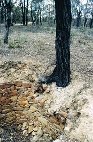 Bendigo Historical Society Inc.
Photograph - DWYER COLLECTION: STONE WELL, MAIDEN GULLY
Photograph: image of stone well, Biffins Track, Maiden Gully. Circular structure lined with sandstone type stones. Measures 3.7 mt. across at widest point and is approx. 2.7 mt. deep. Large Ironbark on RH side of well. File contains letter from Mrs. Michele Dwyer, 27 Katherine Cres., Maiden Gully, dated 19th. Feb. 2003. Inspection by Kay MacGregor and Phil Wilkin in 2012 revealed well still intact, and on private property, not Crown Land. No heritage listing for well.bendigo, buildings, stone well, maiden gully, stone well, stonework, stone cutter. -
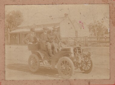 Bendigo Historical Society Inc.
Photograph - J L FAUL, BILL LANSELL & RISING SUN HOTEL - PHOTO, 1905
Photograph. J L Faul, Bill Lansell & Rising Sun Hotel - photo. Cardboard mounted photograph of 3 men in a 2 seater motor car with the Rising Sun Hotel in the background. Two men in photo - J L Faul & Bill Lansell. Photo dated 1905. Rising Sun Hotel is a stone and brick structure with a tin roof. Picket fence and post and rail fence visible. On the back: J L Faul, driver; 1905, somewhere in Victoria (in pen) 8/1905 in pencil.photograph, j l faul, bill lansell, rising sun hotel -
 Bendigo Historical Society Inc.
Photograph - COHN BROTHERS COLLECTION: ROBINVALE HOTEL, 1920's ?
Sepia tone photograph of a two storey building, there are water tanks at both ends. On the left hand side of the centre portion of the building there is a flat top verandah consisting of 3 archways along the front and one at each end. There is a sign above the archways reading 'Robinvale hotel'. On the right of the Centre there is a much smaller structure consisting of 1 archway at the front and 1 on the right hand side, above the front archway there is a sign reading 'Bar'. In front of the Hotel on the left hand side there is a 1920's vintage car parkedbuildings, hotel, robinvale, cohn brothers , robinvale hotel -
Whitehorse Historical Society Inc.
Article, Rezoning plan riles retailers, 1992
Despite widespread disapproval by traders and residents, Nunawading Council still plans put its draft structure plan for Vermont South Activity Centre on public display.Despite widespread disapproval by traders and residents, Nunawading Council still plans put its draft structure plan for Vermont South Activity Centre on public display. Council owned land on Burwood Highway is earmarked for rezoning to restricted business zone. The draft has designated the area for a mix of office and retail development. it is not intended to duplicate retail services which already exist. Manager of Vermont South Shopping Centre Patricia Wilson says the traders object to any amount of extra retail development.Despite widespread disapproval by traders and residents, Nunawading Council still plans put its draft structure plan for Vermont South Activity Centre on public display.shops, city of nunawading, wilson, patricia, vermont south shopping centre, burwood highway, vermont south, nos 473-493 -
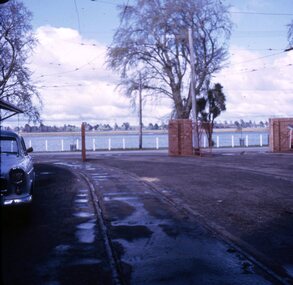 Ballarat Tramway Museum
Slide - 27 mm sq slide/s - set of 3, Lilian Butler, SEC Wendouree Parade depot
Yields information about the Wendouree Parade depot at the time of closure of the SEC operated system.Set of three Colour 27 x 27 mm slide in Kodachrome white cardboard mounts showing various views and scenes at the SEC Wendouree Parade depot .1 - view looking from the depot doors toward the lake. .2 - view looking from behind the toilet block along the west western wall showing parked cars and the structure of part of the front of the depot. .3 - view from Wendouree Parade showing toilet blocks and the overhead and signal lamp. Photo from the collection of Lilian Butler. ballarat, tramways, trams, depot, sec depot, overhead, signals -
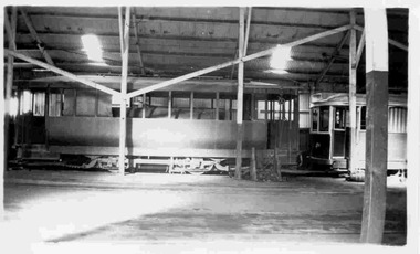 Ballarat Tramway Museum
Photograph - Black & White Photograph/s, Keith Kings, 14/03/1949 12:00:00 AM
Black and White photograph contained with Reg. Item 1902 - Photo Album from Keith Kings to Les Denmead 1970. Photograph of SEC Ballarat Scrubber or track cleaning car inside depot, taken 14/3/1949. Has a single truck tram car on the right side of the scrubber car and an armature and other parts on the floor of the depot. Also shows cross bracing structure of the depot. Keith Kings No. B(w)(6) Scanning: i - image file, p - presentation file, b - back of photograph.Stamp in top left hand corner and handwritten number with "K.S. Kings No. B(w)(6) Copyright reserved". In blue ink "Ballarat / Track cleaning car / Depot / 14/3/49"trams, tramways, ballarat, depot, track cleaner, scrubber tram, tram scrubber -
 Kew Historical Society Inc
Map, MMBW, MMBW Plan No.39 Kew & Heidelberg, 1900-1910
The Melbourne and Metropolitan Board of Works (MMBW) was established by an act of the Victorian Parliament in 1890 to prepare for and to implement a sewerage and water reticulation system across what was then inner Melbourne, its surrounding and middle distance suburbs, including Kew. The MMBW was disbanded in 1991.The map collection of the Kew Historical Society has at its core the historic maps assembled and originally stored in the City Engineer's Department of the City of Kew. These include maps in a number of scales. The vast majority of maps were produced by the MMBW in the first two decades of the twentieth century, and are solid working maps, backed by linen for durability. These maps are historically significant to Kew, the City of Boroondara and to the history of the development of state utilities in Victoria. A number of the Kew maps have additional details added by former municipal officers, including the levels reached by various floods. As these were working documents, information was added to them long after the period of their initial production and distribution.Early map of part of the Borough of Kew, created in the first decade of the twentieth century, at a scale 160 ft to 1 inch. The map covers what was then the north western section of Kew, bordered on its north by Wills Street and the Kew Lunatic Asylum, in the west by the River Yarra [and the later added Yarra Boulevard] , by Princess Street in the East and Holroyd Street in the south. The map shows the extent of urban development by that time, prominent institutions and the outlines of built structures in the municipality. Contour lines were added in ink to the map at a later stage.MELBOURNE AND METROPOLITAN BOARD OF WORKS / PLAN NO. 39 / KEW & HEIDELBERGmelbourne & metropolitan board of works, mmbw maps, mmbw plans, borough of kew, cartography -
 Kew Historical Society Inc
Map, MMBW, MMBW Plan No.67 Kew, 1900-1910
The Melbourne and Metropolitan Board of Works (MMBW) was established by an act of the Victorian Parliament in 1890 to prepare for and to implement a sewerage and water reticulation system across what was then inner Melbourne, its surrounding and middle distance suburbs, including Kew. The MMBW was disbanded in 1991.The map collection of the Kew Historical Society has at its core the historic maps assembled and originally stored in the City Engineer's Department of the City of Kew. These include maps in a number of scales. The vast majority of maps were produced by the MMBW in the first two decades of the twentieth century, and are solid working maps, backed by linen for durability. These maps are historically significant to Kew, the City of Boroondara and to the history of the development of state utilities in Victoria. A number of the Kew maps have additional details added by former municipal officers, including the levels reached by various floods. As these were working documents, information was added to them long after the period of their initial production and distribution.Early map of part of the Borough of Kew, created in the first decade of the twentieth century, at a scale 160 ft to 1 inch. The map covers what was then the north central part of Kew, bordered on its north by the Outer Circle Railway Spruzen and Beresford Avenues, in the west by Princess Street, in the south by High Street, and in the east by (about) Belford Road. The map shows the extent of urban development by that time, prominent institutions and the outlines of built structures in the municipality. Contour lines were added in ink to the map at a later stage.MELBOURNE AND METROPOLITAN BOARD OF WORKS / PLAN NO. 67 / KEW melbourne & metropolitan board of works, mmbw maps, mmbw plans, borough of kew, cartography