Showing 113084 items
matching road
-
 Whitehorse Historical Society Inc.
Article, Traders seething at trial road closure, 2004
Mitcham traders are opposed to the closure of the service road entrance from Whitehorse Road to McDowall Street for a three month trial.Mitcham traders are opposed to the closure of the service road entrance from Whitehorse Road to McDowall Street for a three month trial.Mitcham traders are opposed to the closure of the service road entrance from Whitehorse Road to McDowall Street for a three month trial.whitehorse road, mitcham, mcdowall street, mitcham, roads and streets -
Whitehorse Historical Society Inc.
Document - Correspondence, Healesville Road, 2/08/1937
Claim for reimbursement from Country Roads Board for amounts expended on Main Healesville and Burwood Roads by Shire of Blackburn and Mitchamshire of blackburn and mitcham, victoria. country roads board, healesville road, roads and streets, burwood road -
Whitehorse Historical Society Inc.
Document - Correspondence, Healesville Road, 16/08/1937
Claim for reimbursement from Country Roads Board for amounts expended on Main Healesville and Burwood Roads by Shire of Blackburn and Mitchamshire of blackburn and mitcham, victoria. country roads board, roads and streets, healesville road, burwood road -
Whitehorse Historical Society Inc.
Document - Correspondence, Healesville Road, 16/11/1937
Claim for reimbursement from Country Roads Board for amounts expended on Main Healesville and Burwood Roads by Shire of Blackburn and Mitchamshire of blackburn and mitcham, victoria. country roads board, healesville road, burwood road, roads and streets -
 Whitehorse Historical Society Inc.
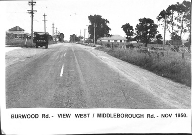
Photograph, Burwood Road - 1950, 1/11/1950 12:00:00 AM
Black & white photograph taken of Burwood Road in November 1950 - View west corner of Middleborough Road, November 1950.burwood road, burwood, middleborough road -
 Whitehorse Historical Society Inc.
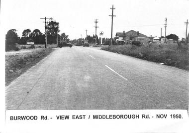
Photograph, Burwood Road 1950, 1/11/1950 12:00:00 AM
Black and white photograph of Burwood Road. View east - corner of Middleborough Road Burwood in November 1950. 4 Copies.burwood road, burwood, middleborough road -
 Whitehorse Historical Society Inc.
Photograph, Whitehorse Road Mitcham No.427, 2001
Coloured photograph of 427 Whitehorse Road - corner Dunlavin Road - Mitcham before renovations commenced. Compare with NP2519 & NP2520whitehorse road, mitcham no 427, dunlavin road, mitcham -
 Whitehorse Historical Society Inc.
Photograph, Deep Creek Road, Mitcham, 1/01/2001 12:00:00 AM
Black and white photograph of Deep Creek Road, Mitcham taken from lower entrance of Schwerkolt Cottage Reserve showing Glenvale Road on left. Photo taken before work started on new road and bridge.deep creek road, mitcham, glenvale road, ringwood -
 Surrey Hills Historical Society Collection
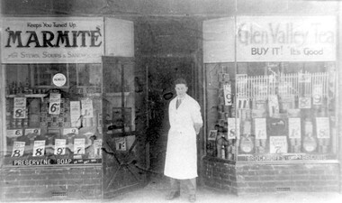
Photograph, Edward Blanchford Wright's grocery shop, Canterbury Road, Surrey Hills
Edward Blatchford Wright was born in 1894 in Birmingham, son of Edward Wright and Florence Emuss. It is not known when he migrated to Australia but he served in the AIF during WW1, seeing action in France. On enlistment aged 20 years 9 months, he gave his occupation as farmer. He married Gertrude Matilda Wain in 1919. He came to Surrey Hills c1924. He was a grocer in the area for several decades with shops in Canterbury Road. In 1942 he is listed at 235 Union Road. This was a residential address. Alan Holt's Surrey Hills property register places him at 365 Canterbury Road (c1920-1930) and 359 Canterbury Road (c1930-1940). He died in 1972 in Mont Albert. His last electoral roll entry in 1968 gives 18 Serpentine Street, Mont Albert. He and his wife are buried in Burwood Cemetery.Black and white photo of the exterior of Edward Blanchford Wright's grocery shop in Canterbury Road, Surrey Hills. The screen door is open and William Reynolds stands in the opening, dressed in a long white coat. The window displays are stacked high with cans and packages and large signs advertising the prices of goods. There is advertising on the windows for Marmite, Glen Valley tea, Preservene soap and Brockoff's biscuits. advertising, shops, grocers, businesses, union road shops, edward blatchford wright, william reynolds, burwood cemetery, world war 1, canterbury road -
 Eltham District Historical Society Inc
Photograph, Fountain Hotel, Main Road, Eltham
Digitised from scanned print of original postcard of Fountain Hotel, Main Road Eltham (later Evelyn Hotel) early view showing two storey section. Built in 1852 as the Fountain of Friendship Hotel, later named the Fountain Hotel in the 1880s. Located on the southwest corner of Maria (Main) and Pitt streets. Later known as the Evelyn or Evelyn Arms Hotel, it was de-licensed in 1919. The hotel was totally destroyed by fire on Wednesday, February 18, 1931Digital file scan of photo print copy and photocopy of original image of Fountain Hotel, Main Road Eltham (later Evelyn Hotel) early view showing two storey sectionhotels, eltham, fountain hotel, evelyn hotel, main road, pitt street -
 Eltham District Historical Society Inc
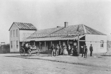
Photograph, Marian Mitchell (nee Robinson), Main Road, Hurstbridge, 7 Aug 1971
Apparently the garage belonged to Peter Brock’s family for which it was locally known and referred to as “Brock’s Garage”."Main Road Hurstbridge" on front On reverse of image: Hurstbridge Main Road Aug 7 1971 Taken by Narian Mitchell (nee Robinson)"fc holden station sedan, hurstbridge, hurstbridge motors, main road, shell service station, peter brock, brock's garage -
 Ringwood and District Historical Society
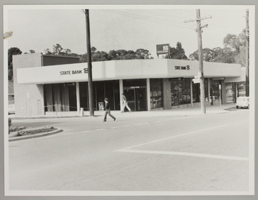
Photograph, Ringwood North State Bank , south-east corner of Dickson's Cresent and Warrandyte Road
Photo of the new Ringwood North State Bank premises, opened 23 January 1983At the corner of Dickson's Cresent and Warrandyte Road, Ringwood North. Photographer - Les Gorrie Photography, 28 Waldemar Road, Heidelberg. Negative #82335 -
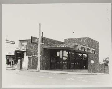 Ringwood and District Historical Society
Photograph, Ringwood North State Bank , north-east corner of Dickson's Cresent and Warrandyte Road
The new Ringwood North State Bank premises, November 1979 on the north-east corner of Dickson's Cresent. Exterior view.At the corner of Dickson's Cresent and Warrandyte Road, Ringwood North. Photographer - Les Gorrie Photography, 28 Waldemar Road, Heidelberg. Negative #2389 -
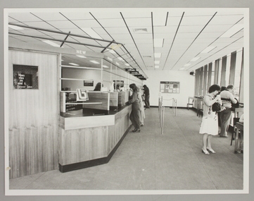 Ringwood and District Historical Society
Photograph, Interior of Ringwood North State Bank , south-east corner of Dickson's Cresent and Warrandyte Road
The new Ringwood North State Bank premises on the south-east corner of Dickson's Cresent. Showing customer service area. Opened 23 August 1982At the corner of Dickson's Cresent and Warrandyte Road, Ringwood North. Photographer - Les Gorrie Photography, 28 Waldemar Road, Heidelberg. Negative #82334 -
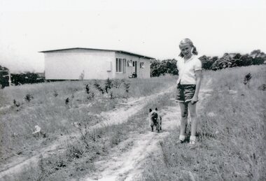 Park Orchards Community House
Photograph, 121 Arundel Road, Park Orchards property in summer 1958, Q4 1958
Catherine O'Connor with "Tinker". The dirt track is Arundel Road. The house is at (Lot 87) 121 Arundel Road, Park Orchards in Summer 1958. -
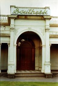 Kew Historical Society Inc
Photograph, Entrance to ‘Southesk’, Cotham Road, 1970
Colour enlargement of a photograph (slide) of Southesk (formerly Ordsall) in Cotham Road, Kew (demolished 1970).Rare colour photograph of the exterior of SoutheskA colour enlargement of the entrance to ‘Southesk’. Formerly known as ‘Ordsall’, the house was built for John Halfey in 1882 on the corner of Cotham Road and Charles Street. This Italianate mansion was built in the Renaissance villa style on a bluestone plinth. The picture provides photographic evidence of the tiling on the veranda and the typically arched doorway. The neon sign above the door was added during the period when it was owned by the City of Kew (1948-70).david carnegie, john halfey, southesk - cotham road - kew (vic), ordsall - cotham road - kew (vic) -
 Ballarat Heritage Services
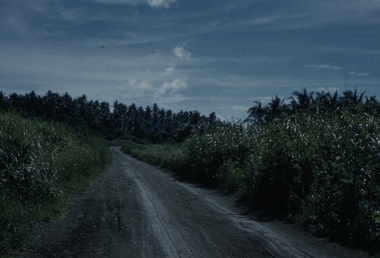
Slide, Dorothy Wickham, Road to Idlers Bay, Papua New Guinea, 1958
This photograph was taken around 1958.Scanned from a coloured slideView from this sidepapua new guinea, port moresby, papuans, road, idlers bay -
 Ballarat Heritage Services
Slide, Dorothy Wickham, Road to Idlers Bay, Papua New Guinea, 1958
This photograph was taken around 1958.Scanned from a coloured slideView from this sidepapua new guinea, port moresby, papuans, road, idlers bay -
 Ballarat Heritage Services
Slide, Dorothy Wickham, Bay Road, Papua New Guinea, 1958
This photograph was taken around 1958.Scanned from a coloured slideView from this sidepapua new guinea, port moresby, papuans, road, idlers bay -
 Ballarat Heritage Services
Photograph - Photograph - Colour, Clare Gervasoni, Treed road behind St Laurence O'Toole Catholic Church, Sandon, 2017, 16/07/2017
St Laurence O'Toole church and cemetery is located in a rural setting at 801/821 Creswick-Newstead Rd, Sandon. Originally a small wooden school (22’x14’) was erected in Sandon by Father Patrick Smyth (who was involved in the Eureka Stockade movement) in 1859. It was also used for Mass and became known as a chapel. In June 1882 tenders were called for the construction of a brick Church by the Castlemaine architect, T.F. Kibble, and it was built at a cost of 1000 pounds. The church was blessed by Archbishop Goold on 06 May 1883 and dedicated to St Laurence O'Toole. The brick building demonstrates original design qualities of a Victorian Rudimentary Gothic style, including the steeply pitched, parapet gable roof form, together with a central steeply pitched, gabled porch that projects slightly from the main gable end. Other intact qualities include the exposed brick wall construction, lapped galvanised corrugated iron roof cladding, minor gabled porch at the rear, small ventilation dormers nearby the roof ridgeline, series of stone steps that lead to the central porch with its double pointed door opening and vertical boarded doors, simple rose window in the main gable end, pointed windows, brick buttresses with double lower copings, and the light masonry detailing (the banding marking the floor level within, buttress copings, window and door surrounds and quoins, and the drip moulds).(Shire of Mount Alexander: Heritage Study of the former Shire of Newstead, 2000) The visually connected cemetery demonstrates important visual qualities formed by the regular rows of graves and cemetery architecture, and the grassed and treed rural landscape. It is a rare and substantially intact example of a Victorian Catholic Church with a cemetery in its churchyard. Many headstones and cemetery architecture, date from the 19th century and represent some fine examples of masonry craftsmanship. Some refurbisments occurred during the 1940s and in 2002 a major restoration project was undertaken from roof to footings, by a dedicated band of volunteers and trades people. Work was completed mid 2003 and in November 2003 St Laurence’s was re-dedicated with the celebration of Mass and a picnic tea. Colour photograph of bushland behind a church at Sandon, Victoria.sandon, sandon cemetery, st laurence o'toole catholic church, sandon, landscape, road -
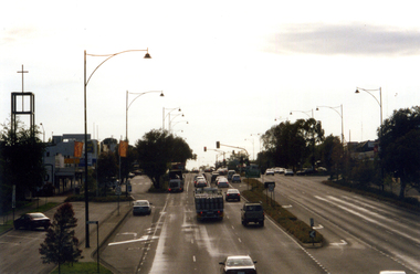 Whitehorse Historical Society Inc.
Photograph, Whitehorse Road, Mitcham
Coloured photograph of Whitehorse Road, Mitcham. Lights are at the junction of Whitehorse and Mitcham Roads and traffic on left is heading east towards Ringwood. Church on the left is the Mitcham Anglican Church, which is on the corner of Whitehorse Road and Edwards Street.whitehorse road, mitcham -
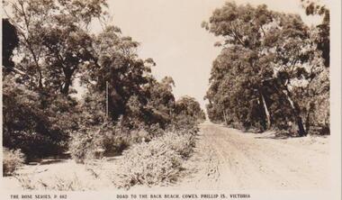 Phillip Island and District Historical Society Inc.
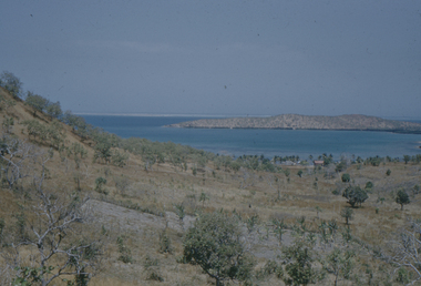
Photograph, Cowes, Phillip Island, C 1926
A dirt road - telegraph polesRoad to the Back Beach, Cowes, Phillip Island, Victoria. The Rose Series P662The Rose Series P662. Road to the Back Beach, Cowes, Phillip Is., Victorialocal history, postcards, cowes back beach, dirt road, sepia photograph, ian reiher, rural, cowes, phillip island -
Whitehorse Historical Society Inc.
Map, Springvale Road, 1975
Aerial photograph of area around cnr. of Springvale Road and Burwood Highway, south past Highbury Road and East in Vermont South.Aerial photograph of area around cnr. of Springvale Road and Burwood Highway, south past Highbury Road and East in Vermont South.Aerial photograph of area around cnr. of Springvale Road and Burwood Highway, south past Highbury Road and East in Vermont South.aerial photographs, vermont south, highbury road, burwood east, burwood highway, burwood east, burwood east -
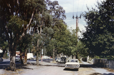 Whitehorse Historical Society Inc.
Photograph, Canterbury Road, Vermont, C.1967, C.1967
Part of Tim Shambrook's Collection for 'This is Vermont'. Not used.Coloured photo of Canterbury Road, Vermont, taken from outside Vermont Primary School (since demolished) on corner of Mitcham Road.vermont state school, no. 1022, canterbury road, vermont, shambrook, tim -
 Bacchus Marsh & District Historical Society
Map, Main Road and Gell Street Allotments
This map shows allotments of land along Gell Street Bacchus Marsh running between Main Road (now called Main Street) and Lerderderg Street. The total area of the map encompasses Main Road, Church Street, Lerderderg Street and Gell Street. 36 allotments of land are shown. Three allotments which connect to Main Road are shaded in pink. The date of the map has not been established but the National Bank building erected in 1865 near the Border Inn is indicated which indicates that the map dates from after 1865. Reports in the Bacchus Marsh Express newspaper on 5 March 1870, page 2, column 6 announced building lots in Gell Street had been withdrawn from sale by the agent J.E. Crook. Later reports in the Express on 1 November 1873, page 2, column 2 advertised 14 allotments of land in Gell Street for sale. Single page map showing allotments of land along the Main Road (Main Street) and Gell Street areas of Bacchus Marsh. Part of a set of maps which are pasted into a bound volume containing 76 maps or plans in total. High resolution digital image stored on BMDHS computer network. bacchus marsh victoria maps, gell street land allotments, main street land allotments -
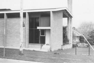 Ringwood and District Historical Society
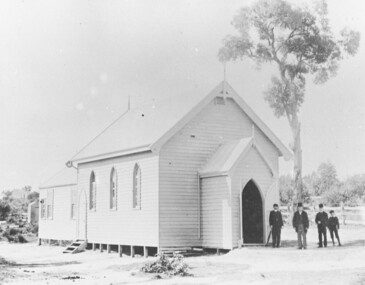
Photograph, Lutheran Church in Wantirna Road, Ringwood in 1974, 1974
Lutheran Church in Wantirna Road in 1974Written on back of photograph, "5.10.74" -
 Ringwood and District Historical Society
Photograph, St Paul's Church, Whitehorse Road, Ringwood, Vic. circa 1910
St Paul's Church on Whitehorse RoadWritten on back of photograph, "St. Paul's on highway." -
 Eltham District Historical Society Inc
Photograph, Heidelberg-Kinglake Road, Hurstbridge; looking north east towards Kinglake
Two colour photographs taken near the location of the present roundabout intersection of Anzac Road (on right) and Arthurs Creek Road (on left) with the Heidelberg-Kinglake Road at Hurstbridge. [37�38'14.8"S 145�11'39.6"E -37.637459, 145.194322]main street, kinglake road, heidelberg/kinglake road, hurstbridge -
 Kew Historical Society Inc
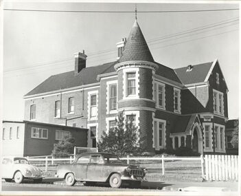
Photograph, Kew RSL, Cotham Road, circa 1965, c. 1965
The Kew RSL is located in "Wilton" House, 63 Cotham Road. The RSL was established on January 1st 1920, later joining with the Hawthorn RSL. In November 1931, Cr. C.R. Parry organised the reformation of the Kew Sub Branch and its first president was Brig-Gen Pat McGlin, a veteran of the Boer War and the First World War. On July 17th 1932, the club rooms first opened on Army land at the corner of High Street and Highbury Grove. In late November 1948, the Kew RSL bought the "Wilton" house from the Kew City Council for £10,067, opening seven years later in July 1955. [Source: Victorian Heritage Database]This work forms part of the collection assembled by the historian Dorothy Rogers, that was donated to the Kew Historical Society by her son John Rogers in 2015. The manuscripts, photographs, maps, and documents were sourced by her from both family and local collections or produced as references for her print publications. Many were directly used by Rogers in writing ‘Lovely Old Homes of Kew’ (1961) and 'A History of Kew' (1973), or the numerous articles on local history that she produced for suburban newspapers. Most of the photographs in the collection include detailed annotations in her hand. The Rogers Collection provides a comprehensive insight into the working habits of a historian in the 1960s and 1970s. Together it forms the largest privately-donated collection within the archives of the Kew Historical Society.The exterior of the Kew RSL on the corner of Cotham Road and Charles Street, Kew. Designed by Guyon Purchase for Dr. William Walsh in 1886, the building was originally called Wilton."Chap 59. Cotham Rd. Built/Commences about 1885-6. Present day Wilton . Kew RSSUILA rooms. (Rumour of sale 1972?)"wilton, dr william walsh, guyon purchas, dorothy rogers, cotham road (kew) -
 Federation University Historical Collection
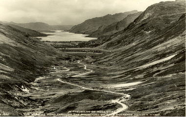
Postcard - black and white, J.B. White Ltd, In the Wilds of Rosshire - The Winding Road Through the Mountains of Glen Docherty to the Loch Maree
Volcanic activity in this region ceased about 50 million years ago, after which the landscape was shaped by glaciation from about 1.8 million years ago to the end of the Great Ice Age about 10,000 years ago. The U-shaped glen of Glen Docherty is typical of a glen formed by the action of glaciers. (wikipedia)Black and white photographic postcard showing a road running between Glen Docherty and Loch Maree. The A832 road runs through the glen.chatham-holmes family collection, rosshire, glen docherty, loch maree, mountains, scotland