Showing 7081 items
matching significance
-
 Eltham District Historical Society Inc
Photograph - Digital Photograph, Marguerite Marshall, St John's Anglican Church, Diamond Creek, 7 September 2008
The building was designed by Charles Maplestone of Heidelberg, son-in-law to Anthony Beale of St Helena. Maplestone was a prominent architect who came out to Australia with his family in 1852. The foundation stone was laid by Mrs Isabella Maplestone on 11th November 1867. The bricklayers for the church were George Stebbing, H Limmer, H Spicer and a Mr Timm while Thomas Day was the stonemason. Another three years were to pass before sufficient money could be raised for its completion. It was opened by Bishop Perry on 1st November, 1870. The church bell which hung under a tree for 50 years until it was incorporated in the parish hall was brought out from England and presented by Charles Orme. In 1916, the estate of George Martin Pizzey left sufficient money to build the red brick hall, which still stands today (2023) though in January 1969 the hall and bell tower were badly damaged by bushfire. Coincidentally the former home of benefactor, George Pizzey was destroyed in the same fire. Of particular significance are the interior and exterior of the church, the Sunday school and hall with emphasis on pre-World War I fabric (excluding the 1990s additions) and the three coloured glass windows currently suspended in the 1990s entry foyer. In 2011 further alterations were made to the front of the Church. The church is historically significant because it was the oldest public building in the former Diamond Valley Shire, is amongst the oldest buildings in the Shire of Nillumbik and is associated with the early settlement of the Diamond Creek district. The church is historically, socially and spiritually significant because it has been a place of worship for over 150 years and continues to be, an important meeting place in the Shire. The church is aesthetically significant for the three stained glass windows executed by the noted stained glass manufacturers, Ferguson & Urie, as well as the supporting coloured glass windows in the church. The Sunday school & parish hall is architecturally significant because the hall is a well executed and preserved example of the work of noted church architects, North & Williams. It is historically significant because it is connected with local parishioner and Melbourne industrialist, George Pizzey, who bequeathed funds for its construction. Covered under Heritage Overlay, Nillumbik Planning Scheme. National Estate Ntionl Trust of Australia (Victoria) Local significance Published: Nillumbik Now and Then / Marguerite Marshall 2008; photographs Alan King with Marguerite Marshall.; p85 St John’s Anglican Church stands like a beacon on the hill on Main Street, Diamond Creek. Today the church has a large congregation, but its early years were marked by a small congregation struggling to find enough money to survive. It was gold in Diamond Creek that resulted in the building of this National Trust registered property.1 This church is far removed from William Wilson’s humble barn (later the Bowling Green) where the first Anglican church services were conducted – probably the first in the district.2 In the mid 19th century services were infrequent as the Rev Francis Hales, travelling on horseback, also conducted services elsewhere, including at Heidelberg, Coburg, Kinglake, Arthurs Creek, St Andrews and Kangaroo Ground. In 1860 Diamond Creek came under the jurisdiction of the Eltham Parish. Until the mid 1860s the Diamond Creek settlement included only about 20 families who were struggling farmers. But this changed when gold was found in 1862. Then the township grew to 200 families, including miners, civil administration workers and shopkeepers. The resulting growth of Church of England adherents prompted them to petition the Government in 1866 for land to build a church. The area chosen, on which the original building still stands, was at the centre of the proposed township. Today church leaders believe that this conspicuous location is one of the reasons for its exceptional growth. Prominent architect Charles Maplestone designed the building as he did the Presbyterian Church at Kangaroo Ground. St John’s, which is still intact, was built in the Gothic Revival style with the traditional rectangular plan of a central nave and sanctuary at the end. It is typical of small churches built in Victoria at that time, with polychromatic hand-made bricks, a porch, diagonal buttresses and a slate roof.3 The church was officially opened by Lord Bishop Perry on November 1, 1870. But during the next 40 years, due to the varying fortunes of gold mining, the church struggled to remain viable. In 1909 it separated from the Eltham Parish to form a parish with Greensborough. Life became more difficult with the privations of World War One. Then disaster struck in 1915 when fire destroyed the Diamond Creek Gold Mine, wiping out the major livelihood of most parishioners. However the church’s morale was lifted in 1916, when it received a bequest to build the red brick hall, from late parishioner and prominent leather manufacturer, George Pizzey. As prosperity grew, in 1924 the congregation separated from Greensborough, but they rejoined in the 1930s Depression. In the 1950s the wider population soared, impacting on St John’s, and it became a separate parish, becoming responsible for six churches at St Andrews, Hazel Glen, Hurstbridge, St Helena and Yarrambat. As parishioner numbers outgrew the building, extensions were added in 1989 and then in 1993, blending in well with the original building. Church members have made a huge contribution to the local community. John Ryan was a Heidelberg Shire Councillor for 25 years from 1931, Mayor in 1939 and headed several local sporting and other organisations. His son Jock became a clergyman and a local historian heading the Nillumbik Historical Society. Another parishioner, Dr Ted Cordner, came to Diamond Creek in 1920. One of his sons Donald, who was a local doctor, won the Brownlow Medal, was President of the Melbourne Cricket Club and President of the Melbourne Grammar School Council. Roy ‘Monty’ Vale was a state Liberal MP and was related to May Vale, a member of the Heidelberg School of Artists.4 In the early 21st century St John’s Anglican Church is one of the fastest growing congregations in Melbourne. References: St Johns Anglican Church complex, Sunday School and Parish Hall 61 Main Street DIAMOND CREEK, NILLUMBIK SHIRE. (2023, June 7). Retrieved from https://vhd.heritagecouncil.vic.gov.au/places/64023 Diamond Creek, VIC. – St John’s Anglican (2023, June 7). Retrieved from https://www.churchhistories.net.au/church-catalog/diamond-creek-vic-st-johns-anglican This collection of almost 130 photos about places and people within the Shire of Nillumbik, an urban and rural municipality in Melbourne's north, contributes to an understanding of the history of the Shire. Published in 2008 immediately prior to the Black Saturday bushfires of February 7, 2009, it documents sites that were impacted, and in some cases destroyed by the fires. It includes photographs taken especially for the publication, creating a unique time capsule representing the Shire in the early 21st century. It remains the most recent comprehenesive publication devoted to the Shire's history connecting local residents to the past. nillumbik now and then (marshall-king) collection, st john's anglican church, diamond creek -
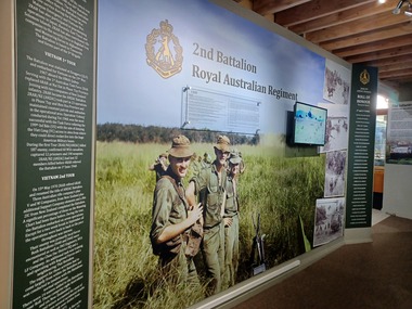 National Vietnam Veterans Museum (NVVM)
Poster - Poster, Information Board, 2nd Battalion Royal Australian Regiment
Three piece Poster, Information Board. Left on dark green background with yellow Corps Emblem with white text on the history of Vietnam during their 1st and 2nd tour. Centre section there is a coloured photograph of four soldiers standing in a field and four black and white Photograph to the right of the board of soldiers patrolling and resupplying with helicopter. On the right on a dark green background is a Roll of Honour to the many soldiers who lost their lives in Vietnam.2 RAR: This photo was taken by Elvon King of Delta Company in September of 1967. This photo was chosen without the knowledge of the historical significance of the shot, which proved to be very momentous. For within a very short time (about 30 seconds) of the photo being taken a wayward rocket from a U.S. gunship landed amongst this group of men in the photo, resulting in three of them being killed and forteen being wounded. Elvon King was one of the wounded. The three men in the photo are left to right Dennis (Dave) Enright who lost a and foot in the incident. Harry Leggett who received shrapnel wounds, and Stan Radomi who was killed outright. A very poignant moment in time. these thoughts about the incident from Wally Musgrave was one of those severly wounded at the time. What could have been a sunny afternoon at a Newcastle or Bondi Hotel or beer Garden..... After what could have been a week of patrolling, it was back inside the wire to scrub up and top up on fluids. Next morning, at 9.00, we went out side of the wire for a fire power, demonstration to satisfy a visiting General. The sun was shining, no seating, grass wasn't cut but we were young and so we thought bullet proof. then someone asked for the old Iroguois gun ship which had been firing rockets at a dead tree to be swung around to fire rockets over our heads. Why?? I haven't given "why" that much thought, but the 1 metre long port side rocket tumbled down amongst us and I'm sure everyone who was there can close their eyes and still see it today. This tumbling rocket landed where these three mates were standing amongst 11 and 12 platoon's young soldiers, chatting in the sun, then we were sailing through the air. I didn't see the devastation myself. I was under bodies. As first Dustoff priority we were off to 36 Evacuation Hospital at Vung Tau. There were two doos, one to the Morgue and one at the Hospital. Lucky me. I went through the Hospital door. eight major operations at once. three dead, forteen wounded and nothing on record!! Yeah it was a lovely Sunny Day at Nui Dat., we'll leave it at that! We can't change yesterday. I'm just another Nazho.poster, information board, 2 rar, elvon king -
 The Beechworth Burke Museum
Geological specimen - Basalt (igneous-volcanic) containing Olivine, unknown
This particular geological specimen was found in Mount Franklin or Lalgambook in Djadjawurrung, located between Daylesford and Newstead, approximately ninety minutes drive from Melbourne. The mountain is an example of a breached scoria cone (a steep conical hill of loose pyroclastic fragments) which was created by a volcanic eruption about 470,000 years ago, a date which may indicate the age of this geological specimen. The volcanic eruptions of Mount Franklin were most likely witnessed by members of the Dja Dja Wurrung Aboriginal tribe, who referred to this country as the 'smoking grounds'. Mount Franklin and the surrounding area appears to have been a place of considerable religious significance to Aboriginal people, there is evidence which indicates that frequent large ceremonial gatherings took place in the area. Basalt is the most common rock on Earth’s surface, more than 90% of all volcanic rock on Earth is basalt. Basalt is an aphanitic extrusive igneous rock formed from the rapid cooling of low-viscosity lava exposed at or very near the surface of a rocky planet or moon. Specimens are black in colour and weather to dark green or brown. Basalt is rich in iron and magnesium and is mainly composed of olivine, pyroxene, and plagioclase. Olivine is the name of a group of rock-forming silicate minerals with compositions ranging between Mg2SiO4 and Fe2SiO4. Unlike other minerals, Olivine has a very high crystallisation temperature which makes it the first of the minerals to crystallise from magma. As magma cools, the crystals begin to form and settle on the bottom of the lava and form basalts that are abnormally enriched in olivine in the lower part of lava flows. According to H. M. King (on geology.com) "Olivine is thought to be an important mineral in Earth's mantle. Its presence as a mantle mineral has been inferred by a change in the behaviour of seismic waves as they cross the boundary between Earth's crust and mantle". Lava from Mount Franklin and other volcanoes in the area filled valleys and buried the gold bearing streams that became the renowned ‘deep leads’ of the gold mining era. In 1852, as part of the Victorian gold rush, gold was discovered in the immediate area, this gold was created by lava flows during the Newer Volcanic period, which were mined intensively during the nineteenth century. Around 1865 the presence of a deep lead in Mount Franklin was established. Deep lead mining was initially unsuccessful, and it was not until the late 1870s that the Franklinford Gold Mining Company mined at Mount Franklin on a significant scale. A few years later the Mount Franklin Estate Gold Mining Company also struck gold, followed by the Shakespeare and Great Western companies in the mid-1880s. By the late 1880s, however, deep lead mining had ceased in the area. Soon after gold was discovered in 1851, Victoria’s Governor La Trobe wrote to the Colonial Office in London, urging ‘the propriety of selecting and appointing as Mineral Surveyor for this Colony a gentleman possessed of the requisite qualifications and acquaintance with geological science and phenomena’. Alfred Selwyn was appointed geological surveyor in Australia in 1852 which began the Geological Survey of Victoria. In 1853-69 the Geological Survey issued under Selwyn's direction sixty-one geological maps and numerous reports; they were of such high standard that a writer in the Quarterly Journal of the Geological Society of London bracketed the survey with that of the United States of America as the best in the world. During his years spent in Australia, Selwyn collected numerous significant geological specimens, examples of which are held in collections such as the Burke Museum.This geological specimen is an example of basalt and olivine which shows the volcanic lava activity and geographical specific nature of Mt Franklin as a significant volcanic site. According to Agriculture Victoria 'The crater is one of the deepest in the Central Highlands area. It is a major megacryst site with some of the largest known Victorian examples of megacrysts of augite and an orthoclase. The small parasitic mound of Lady Franklin on the western flanks adds to the geological interest of the site'. This specimen also highlights the locality as a significant place for both indigenous activity and Victorian gold rush era mining practices. This specimen is part of a larger collection of geological and mineral specimens collected from around Australia (and some parts of the world) and donated to the Burke Museum between 1868-1880. A large percentage of these specimens were collected in Victoria as part of the Geological Survey of Victoria that begun in 1852 (in response to the Gold Rush) to study and map the geology of Victoria. Collecting geological specimens was an important part of mapping and understanding the scientific makeup of the earth. Many of these specimens were sent to research and collecting organisations across Australia, including the Burke Museum, to educate and encourage further study.An angular, solid hand-sized piece of grey volcanic Basalt with green/brown Olivine phenocrysts along one flat edge.Olivine in basalt / - label is probably / correct. / C. Willman / 15/4/21burke museum, beechworth, indigo shire, beechworth museum, geological, geological specimen, mineralogy, basalt, igneous rock, igneous-volcanic, volcanic geology, volcanic, olivine, olivine specimen, basaltoid -
 Victorian Interpretive Projects Inc.
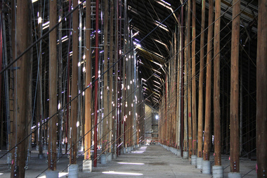
Photograph - digital, LJ Gervasoni, Murtoa Stick Shed 00031, 13/08/2011
From the Victorian Heritage Register statement of significance H0791 The Marmalake/Murtoa Grain Store, originally the No.1 Murtoa Shed, is located within the Murtoa Grain Terminal, adjacent to the grain elevator tower and railway line. The shed is 280m long, 60m wide and 19m high at the ridge with a capacity of 3.4 million bushels. The hipped corrugated iron roof of the shed is supported on approximately 600 unmilled hardwood poles set in a concrete slab floor and braced with iron tie rods. These poles are the reason for use of the term "stick shed". With its vast gabled interior and the long rows of poles the space has been likened to the nave of a cathedral. An elevator at one end took wheat from railway trucks to ridge level where it was distributed by conveyor along the length of the shed, creating a huge single mound of grain. Braced internal timber bulkheads on either side took the lateral thrust of the wheat, and conveyors at ground level outside the bulkheads took wheat back to the elevator for transport elsewhere. Wheat had been handled in jute bags from the start of the Victorian wheat industry in the mid nineteenth century. Bulk storage had been developed in North America from the early 1900s. NSW began building substantial concrete silos from 1920-21. In Western Australia, farmers' co-operatives, who had to supply their own bulk storage from 1934-5, pioneered the use of low-cost horizontal sheds of timber and corrugated iron for bulk storage. Following its establishment in 1935 the Victorian Grain Elevators Board (GEB) planned a network of 160 concrete silos in country locations, connected by rail to the shipping terminal at Geelong. By the outbreak of the Second World War there was a worldwide glut of wheat, and Australia soon had a massive surplus which it was unable to export. Only 48 silos had been established under the Victorian Silo Scheme so far, and wartime material and labour restrictions prevented progress with this scheme. The storage deficit had become an emergency by 1941 as Britain obtained its imports from North America, rather than over the lengthy and difficult shipping route from Australia. In 1941 the GEB, under chairman and general manager Harold Glowrey, proposed large temporary versions of the horizontal bulk storage sheds already in use in Western Australia. The proposal was approved by the Victorian Wheat and Woolgrowers Association, who considered the use of shed storages as a longer term proposition. After initial resistance from the Australian Wheat Board, some of whose members represented wheat bagging interests, the Commonwealth and Victorian governments agreed to split the costs, and Murtoa was chosen as a suitable site for the first emergency storage. The main contractor, Green Bros, commenced work on the No.1 Murtoa Shed in September 1941, deliveries of bulk wheat began in January 1942, and the store was full by June of the same year. In the following years the Council for Scientific and Industrial Research (later CSIRO) conducted valuable research and experiment on the impacts and control of insect pests at the Murtoa No.1 shed. With these discoveries, and the development of more effective pesticides, use of the No.1 shed and the larger No.2 shed, erected in 1942/43, continued for many years. The No.2 shed was demolished in 1975. By the 1990s, pest resistance to pesticides and requirements for both pest free and insecticide free grain rendered open storage of this type unviable. The No. 1 store was also becoming increasingly expensive to maintain, and its use was phased out from 1989.Image of the Marmalake/Murtoa Grain Store which is of historical, architectural, scientific (technical) and social significance to the State of VictoriaDigital colour image of the interior of the Marmaduke . Murtoa grain storage facility better known as the Stick Shed. The shed was constructed in World War Two to store grain. The supporting columns are trees.marmalake, murtoa grain store, wheat store, stick shed, murtoa -
 Bendigo Historical Society Inc.
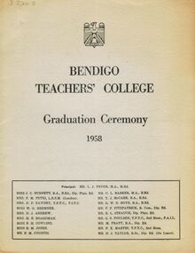
Document - LA TROBE UNIVERSITY BENDIGO COLLECTION: BENDIGO TEACHERS' COLLEGE GRADUATION CEREMONY 1958
A faded document titled "Bendigo Teachers' College Graduation Ceremony 1958". The front cover also contains a list of the staff teaching at the college. They are The Principal Mr. L. J. Pryor, Miss J. C. Burnett, Mrs. F. M. Petri, Mrs. N. F. Fawdry, Miss M. G. Bremner, Mrs. D. J. Andrew, Mrs. M. E. Boardman, Miss B. H. Cowling, Miss E. M. Jones, Mr. F. M. Courtis, Mr. C. L. Barker, Mr. T. J. McCabe, Mr. G. W. D. Boyd, Mr. P. F. Fitzpatrick, Mr. R. L. Strauch, Mr. G. S. Poulsen, Mr. M. Pratt, Mr. F. X. Martin and Mr. N. J. Taylor. On the inside cover is the "Significance of the Ceremony" and the "Order of the Ceremony". Mr. F. M. Courtis gave the Welcome to Visitors and the College Charge was given by the Principal. The 'Graduation Book' was presented to Mr. A. L. Harris by Miss J. C. Burnett. Mr. C. L. Barker called the final roll for 1958 and Congratulations were offered by The Mayor Cr. H. W. Snell J.P. and Mr. R. L. Harrowfield Head Teacher of Golden Square State School. The Occasional Address was given by Mr. J. R. Lyall Assistant Chief Inspector of Primary Schools.The following page contains a list of the "Students of 1957-58" - John Victor Anderson, Margaret Betty Baker, Patricia Ann Banko, George Edward Bazley, Elizabeth Margaret Bower, Nancy Elva Boyle, Enid Gilmour Brown, Wendy Lorraine Bulleid, Fairlie Anne Burkinshaw, Barry Henry Burns, Katherine Alice Byrnes, Bryan Clarke Campbell, Elizabeth Joyce Chapman, Alison Amelia Clark, Valerie Nancy Clough, Georgina Mary Agnes Coppock, Eric Bruce Hindle Coventry, Faye Margaret Crump, Dorothy Lilian Cunnington, Elizabeth Jean Dalrymple, Lois Anne Davies, Brian Leslie Dolan, Moira Margaret Dowd, June Frances Ellis, James Cornelius Finnegan, Graeme Reynolds Fleet, Elaine Rose Fuga, Rosemary June Garonne, James Alfred Geehman, Ronald James Goodman, Bernard Thomas Gray, Dorothy June Gregson, Joy Margaret Ham, Dorothy Rose Harice, Arthur Herbert Harris, Brian Hopper, Dorothy Anne Hosking, Nancy Elizabeth Hughes, Irene Margaret Hynes, Donald James Low, Elspeth Faye McCarthy, Richard James McGowan, Geoffrey Douglas McLean, Junella Maree McPhail, Beryl Martin, Carmel Monica Mullins, Charles Peter O'Connor, Nancy Lorraine Peck, Ian Alwyn Raeburn, Raymond Edward Reardon, Ruth Lorraine Reid, Patricia Margaux Roberts, Robert Herbert Robertson, Phillip Edward Rowe, Lesley Margaret Silke, Francis William Sleeth, Margaret Joy Sloane, Murray Francis Sweeney, Elwyn Beth Thompson, Margaret Ann Wadley, Janet Ann Wallis, Geoffrey Michael Warman, Kevin George Watson, Patricia Anne Weight, Margaret Anne West, Ronald Thomas White and Irene Mary Wolfe. The back page has the "Principal's Charge". There is also a white type written insertion containing the words of the songs and a plan of the seating and movements of the ceremony. Boltons Print, Bendigo.bendigo, education, bendigo teachers' college graduatio, la trobe university bendigo collection, collection, bendigo, bendigo teachers' college, bendigo teachers' college students, education, teaching, teachers, students, graduation, tertiary education, book, graduation ceremony, graduands, history, bendigo teachers' college staff, history -
 Bendigo Historical Society Inc.
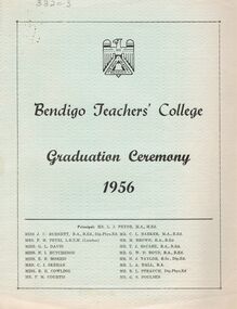
Document - LA TROBE UNIVERSITY BENDIGO COLLECTION: BENDIGO TEACHERS' COLLEGE GRADUATION CEREMONY 1956
A light blue document titled "Bendigo Teachers' College Graduation Ceremony 1956". Also on the front page is a list of the staff working at the college. On the inside cover is the "Significance of the Ceremony" and the "Order of the Ceremony". A welcome to visitors was given by Mr. F. M. Courtis and the Principal gave the college charge. The signing of the 'Graduation Book' was presented to Mr. A. L. Harris Inspector of Schools, by Miss J. C. Burnett. The final call of the roll for 1956 was given by Mr. C. L. Barker. Congratulations were offered by the Mayor Cr. A .S. Craig and Mr. S. J. Tongway Head Teacher of Gravel Hill State School. Finally the Occasional Address was presented by Mr. J. G. Cannon Chief Inspector of Primary Schools. The next page has a list of the "Students of 1955-56". The back page has the "Principal's Charge". Bolton Bros., Printers, Bendigo. The staff members names are Miss J. C. Burnett, Mrs. F. M. Petri, Miss G. L. Davie, Miss N. L. Hutcheson, Miss E. B. Morris, Mrs C. I. Skehan, Miss B. H. Cowling, Mr. F. M. Courtis, Mr. L. J. Pryor (Principal), Mr. C. L. Barker, Mr. M. Brown, Mr. T. J.McCabe, Mr. G. W. D. Boyd, Mr. N. J. Taylor, Mr. L. A. Hall, Mr. R. L. Strauch and Mr. G. S. Poulsen. The graduating students are - Margaret Carolyn Allinson, Robert Eric Allison, Diane Backhouse, Mary Elizabeth Barbour, Patricia Mary Blake, Peter Brian Cook, Edgar Vincent Crampton, Heather Lorraine Dalrymple, Josephine Margaret Delle Vergini, Roy Stanislaus Dickson, Margaret Isobel Diss, Barry Edwards, Margaret Lorraine Edwards, Edith Dawn Ellis, Graeme Leslie Evans, Dorothea Helen Farrell, Maureen Margaret Forrester, Roma June Hamilton, Carmel Catherine Hart, Esma Olive Haw, Margaret Helen Hogben, Beverley Norwood Hutchinson, Ronald Ireland, Edith Dawn Ireson, Joy Amelia Jeffrey, Valerie Margaret Jones, Noel Charles Kilby, Maxene Shirley King, Dorothy Lorraine Lee, Maxwell John Lovelace, Marie Joan Madin, Margaret Mary Mannes, William Daniel Manson, Janice Renyra Martin, Margaret Dawn Merlo, Anne Mills Moodie, Garry Norman Muller, Janice Nancy McKean, Ronald Walter McKendrick, Norma Maud Neal, Trevor Raymond Oakley, Bruce Peake, Marjorie Peile, Elaine Margaret Plant, Helen Rae Rawiller, Lynette Theresa Reid, Philip William Eric Reid, Geoffrey Rolf Richards, Margaret Rodgers, Anne Marie Sanders, Kenneth Maxwell Sargeant, Pamela Marie Saunders, Jessica Evelyn Scoones, Jean Neilson Shadforth, Beverley Mabel Slade, Nancye Elizabeth Smith, Margaret Eleanor Speers, Elizabeth Stewart, Leon Maurice Thompson, Margaret Gwen Till, Maureen Alma Trimble, George Walter Vincent, John Fairbank Phillip Waddington, Joyce May Walker, Austin Edward Walsh, Anne Elizabeth Warman, Raymond Henry Way, Dorothea Lillian Wearne, Aileen Margaret Weeks, Gordon Raymond Williams, Janice Margaret Wood, Doreen Amelia Worsnop and Marie Ethel Wright.bendigo, education, bendigo teachers' college graduatio, la trobe university bendigo collection, collection, bendigo teachers' college, bendigo, education, teaching, teachers, students, bendigo teachers' college staff, bendigo teachers' college students, tertiary education, teacher training, history, graduation, graduation ceremony, graduates, graduands -
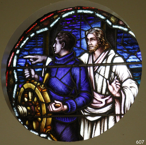 Flagstaff Hill Maritime Museum and Village
Artwork, other - Window, Brooks, Robinson & Co, Christ Showing the Helmsman the Way, circa August 1947
This round, stained glass window, titled "Christ Showing the Helmsman the Way", was installed in the St Nicholas Seamen's Church at 139 Nelson Place, Williamstown, Victoria. The window was referred to as the Sanctuary Window and was installed in the chapel above the altar. This memorial window has significance as a part of Victoria's War Heritage and is listed on the Victorian Heritage Database. The window was donated to St Nicholas Seamen’s Church as a memorial to the members of the Merchant Navy whose lives were lost in the Second World War, 1939-1945. The donor was the Williamstown Lightkeepers Auxiliary, an independent ladies association working with the Williamstown Missions to Seamen (the Missions to Seamen organisation was re-named the Mission to Seafarers in the year 2000). The window was officially dedicated on December 14, 1947 by Geelong's Anglican Bishop, Rt. Rev. J.D. McKie. In the early months of 1948 a bronze plaque was also placed in the chapel above the altar. It recognises the lost souls of the Merchant Navy during World War 2, as well as the donor of the window, the Williamstown Lightkeepers Auxiliary. The inscription impressed on the rectangular bronze plaque, 20.4 x 10.2cm, is as follows: “IN MEMORY OF THE MEMBERS OF THE MERCHANT NAVY WHO WERE LOST IN THE SECOND WORLD WAR 1939-1945 FAITHFUL UNTO DEATH. THE WINDOW ABOVE THE ALTAR WAS ERECTED BY THE WILLIAMSTOWN LIGHTKEEPERS AUXILIARY 1947.” The Williamstown St Nicholas Seamen’s Church ceased operation in 1966. In 1979 the Victoria Missions to Seamen donated this round, stained glass window and the memorial plaque to Flagstaff Hill Maritime Village, along with many other items and furnishings. These items have been used to simulate the Williamstown Mission and Chapel as much as possible. The round space that formerly displayed the window can still be seen at the back of the old St Nicholas Seamen’s Church, previously the ES&A bank, in Williamstown. THE MISSIONS TO SEAMEN (Brief History: for more, see our Reg. No. 611, Set of Pews) The Missions to Seamen, an Anglican charity, has served seafarers of the world since 1856 in Great Britain. It symbol is a Flying Angel, inspired by a Bible verse. Today there are centr4es in over 200 ports world-wide where seamen of all backgrounds are offered a warm welcome and provided with a wide range of facilities. In Victoria the orgainsation began in Williamstown in 1857. It was as a Sailors’ Church, also known as ‘Bethel’ or the ‘Floating Church’. Its location was an old hulk floating in Hobson’s Bay, Port of Melbourne. It soon became part of the Missions to Seamen, Victoria. In the year 2000 the organisation, now named Mission to Seafarers, still operated locally in Melbourne, Portland, Geelong and Hastings. The Ladies’ Harbour Lights Guild was formed in 1906 to support the Missions to Seamen in Melbourne and other centres such as Williamstown. Two of the most significant ladies of the Guild were founder Ethel Augusta Godfrey and foundation member Alice Sibthorpe Tracy (who established a branch of the Guild in Warrnambool in 1920). The Guild continued its work until the 1960s. In 1943 a former Williamstown bank was purchased for the Missions to Seaman Club. The chapel was named St Nicholas’ Seamen’s Church and was supported by the Ladies’ Harbour Lights Guild, the Williamstown Lightkeepers’ Auxiliary and the League of Soldiers’ and Sailors’ Friends. It ceased operation in 1966. A Missions to Seamen Chapel and Recreation Room was a significant feature of ports during the late 1800s and into the 1900s. It seemed appropriate for Flagstaff Hill to include such a representation within the new Maritime Village, so the Melbourne Board of Management of Missions to Seamen Victoria gave its permission on 21st May 1979 for the entire furnishings of the Williamstown chapel to be transferred to Flagstaff Hill. The St Nicholas Seamen’s Church was officially opened on October 11, 1981 and closely resembles the Williamstown chapel. This stained glass window is significant historically for its origin in the St Nicholas Mission to Seamen's Church in Williamstown, established in 1857 to cater for the physical, social, and spiritual needs of seafarers. It was donated to the Mission by the Lightkeepers Auxiliary (Ladies Harbour Lights Guild, which was formed in 1905). The Missions to Seamen organisation had its origins in Bristol, England when a Seamen's Mission was formed in 1837. The first Australian branch was started in 1856 by the Rev. Kerr Johnston, a Church of England clergyman, and operated from a hulk moored in Hobson’s Bay; later the Mission occupied buildings in Williamstown and Port Melbourne. The connection of this window the Mission to Seamen and the Ladies Harbour Lights Guild highlights the strong community awareness of the life of people at sea, their dangers and hardships, and their need for physical, financial, spiritual and moral support. This memorial window has significant as a part of Victoria's War Heritage and is listed on the Victorian Heritage Database, Heritage Number 196973.Window, stained glass, circular, with reinforcing bars. The window represents Christ showing the helmsman the way. It shows a man in blue knitted jumper holding onto a ship's wheel, looking over his right shoulder. Behind him stands a man in a white robe pointing to his right and looking to his left, his left hand gesturing to pause. The background has various shapes and patterns of blue glass, bordered by two arcs, the outer one is white, the inner one is red. This beautiful window is in our St Nicholas Seamen's Church Collection and was brought to Warrnambool from the original St Nicholas Seamen’s Church in Williamstown. flagstaff hill, warrnambool, shipwrecked coast, flagstaff hill maritime museum, maritime museum, shipwreck coast, flagstaff hill maritime village, great ocean road, mission to seamen williamstown, st nicholas seaman’s church williamstown, missions to seamen victoria, mission to seafarers, lightkeepers auxiliary, ladies harbour light guild, 139 nelson place williamstown, religion, religious service, sailors rest, bethel sailors’ church, bethel floating church, e. s. & a. bank williamstown, christ directing a sailor, christ showing the helmsman the way, quartermaster’s hand on the wheel, stained glass window, church window, religious window, sanctuary window, memorial window, war memorial window, victorian war heritage inventory, victorian heritage database, merchant navy ww2, 1939-1945, anglican church, bishop mckie, mrs musther, brooks robinson & co, flying angel club, williamstown lightkeepers' auxiliary, ladies' harbour lights guild, commemorative window -
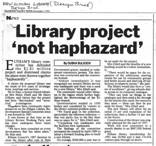
 Eltham District Historical Society Inc
Photograph - Digital Photograph, Alan King, Shillinglaw Cottage, 6 January 2008
Covered under National Estate, National Trust of Australia (Victoria) Local Significance and Heritage Overlay, Nillumbik Planning Scheme. Published: Nillumbik Now and Then / Marguerite Marshall 2008; photographs Alan King with Marguerite Marshall.; p95 Thanks to an Australia first effort by local residents, the historic Shillinglaw Cottage still survives. The cottage at Panther Place, Eltham, once stood about 100 metres away on Main Road. But in 1963 it faced demolition to make room for the Eltham Shire Offices (since demolished). However residents rallied to save Shillinglaw Cottage and became the first in Australia to remove and reconstruct an early settler’s brick building. A fundraiser was the residents’ compilation of loved recipes into the cookery book, Flavour of Eltham. The cottage, built in the late 1870s by noted pioneer builder George Stebbing, is one of Eltham’s earliest buildings and associated with significant early settlers. It is on the National Estate and National Trust Registers. The cottage was constructed with handmade bricks in the Flemish Bond style, typical of cottages and farmhouses in Flanders, Europe. It features burnt ‘header’ bricks over the façade, which gives a chequered effect. The roof is made of slate, while the windows are 12-paned sash with relieving arches. It is not clear who were the first owners of the cottage. The National Trust claims that Stebbing built it for farmer Thomas Cochrane.1 Others say Cochrane first owned the land but Stebbing was Shillinglaw’s first owner and remained so until 1887. The Shillinglaw family then bought it and lived there for around 80 years until 1963 when they sold it to the Eltham Council.2 Farmer Thomas Cochrane bought the Shillinglaw Cottage site from land developer Josiah Holloway. The site was the largest in what Holloway called Little Eltham, of some 30 acres (12 ha), extending along the creek from Henry Street to Luck Street. In 1874 Cochrane sold the land to George Stebbing. Meanwhile in 1861, Stebbing was the owner and occupier of a house at Pitt Street, Eltham, which he had built. Evelyn Observer journalist James Rossiter rented the Pitt Street house, then in 1881 Phillip Shillinglaw occupied it. Stebbing constructed several buildings of note in the area, including the Uniting Church at John Street, the building beside it – a former bank – and St Margaret’s Church of England in Pitt Street. Stebbing was also an Eltham Shire Councillor from 1871 to 1873 and a trustee and treasurer of the Eltham Wesleyan Church.3 In the 1870s he is recorded as the owner of up to five houses. Earlier he had been described as a bricklayer and later became a farmer. In 1882 Stebbing returned to the Pitt Street house and Shillinglaw occupied the new house in Main Road, which he owned from 1887. Shillinglaw was a prolific poet and preached at the Eltham Primitive Methodist Church, where he also served as Sunday School superintendent and led the Young People’s Society Christian Endeavour. The Shillinglaws saw many changes in their property’s boundaries – the major one occurring at the turn of the century when land for the railway and Eltham station was acquired from their holding. The northern part of the remaining land was then used for some of the first commercial developments in what was to become the Eltham Shopping Centre. Later still, the land immediately north of the cottage was bought by the Eltham War Memorial Trust for the War Memorial Buildings and the fire station. The Trust’s land eventually passed to the council. The council bought the remaining two acres (0.8 ha) with the house, and with the exception of the commercial development between the fire station and the post office, all of the former Shillinglaw land is owned by the council or government instrumentalities.4 Since the late 20th century, the cottage has had varied uses, such as a handcrafts store and as a restaurant.This collection of almost 130 photos about places and people within the Shire of Nillumbik, an urban and rural municipality in Melbourne's north, contributes to an understanding of the history of the Shire. Published in 2008 immediately prior to the Black Saturday bushfires of February 7, 2009, it documents sites that were impacted, and in some cases destroyed by the fires. It includes photographs taken especially for the publication, creating a unique time capsule representing the Shire in the early 21st century. It remains the most recent comprehenesive publication devoted to the Shire's history connecting local residents to the past. nillumbik now and then (marshall-king) collection, shillinglaw cottage -
 Eltham District Historical Society Inc
Photograph - Digital Photograph, Alan King, Alistair Knox Park, Eltham, 2008
Alistair Knox Park, an oasis of peace and beauty. Covered under National Trust of Australia (Victoria) Landscape Significance and Heritage Overlay, Nillumbik Planning Scheme. Published: Nillumbik Now and Then / Marguerite Marshall 2008; photographs Alan King with Marguerite Marshall.; p173 It is hard to imagine that the Alistair Knox Park, an oasis of peace and beauty beside busy Main Road, Eltham, was once the township’s rubbish dump. It was only in the 1970s that the tip was transformed into this beautiful six hectare space, which later earned it a National Trust Landscape classification. Before its life as a dump, the area was used for small farms. Thanks largely to the foresight and efforts of local environmental builder Alistair Knox, the park was designed sympathetically with the character of the wider Eltham landscape. Then, appropriately, the park was named after Knox, who was an Eltham Shire Councillor from 1971 to 1975 and Shire President in 1975. The park designers were four major forces in the urban bush landscape garden –Knox, landscape designer Gordon Ford, artist Peter Glass and landscaper Ivan Stranger. The National Trust citation for the park, originally called Eltham Town Park, includes the Eltham railway trestle bridge and the Shillinglaw Cottage. The citation states ‘the semi-natural setting of the parkland provides a landscape which is evocative of the history of the area’. Manna Gums (Eucalyptus viminalis) and Candlebarks (Eucalyptus rubida) are significant features. Most of the park’s construction was directed by Bob Grant, Superintendent of the Parks and Gardens Department for the Eltham Shire Council. First plantings occurred in Arbour Week in 1973, then the lake and botanic area were completed in 1975, with Federal Government funding, and the toilet block in 1978. Bounded by the Eltham railway line, Panther Place, Main Road, Bridge and Susan Streets, the park is in a valley about a kilometre wide overlooked by steep hills at the east and west. The Diamond Creek flows through it and the picturesque historic timber trestle railway bridge edges the north. Informal plantings of Australian indigenous and native species in open and undulating grassed settings blend with the natural landscape of the Diamond Creek to the west. The bush-style plants, particularly around the creek, balance with open lawns, paths and a cascade flowing from a small lake to another below. A footbridge over the creek leads to the park’s west. The park includes an adventure playground and barbecue areas. The park stands on part of the land bought from the Crown in 1851 by Josiah Holloway, who subdivided it into allotments and which he called Little Eltham. Most of the land was subdivided into residential lots, but the creek valley, on which the park stands, was subdivided into farm-size lots, used mainly for orchards and grazing. One of the earliest owners was John Hicks Petty, who in 1874 bought a plot from Holloway. Other families who owned properties in that area, included Rees, Clark, Waterfall, Graham, Hill and Morant. In 1901 the railway was built through the area. Jock Read, an Eltham resident since around 1920, remembers several farms in the 1920s and ’30s that occupied the site of today’s park. A poultry farm, which extended from present day Panther Place, was owned by the Gahan family. Next to that farm was another for grazing cattle owned by Jack Carrucan. Beside this was land owned by John Lyon. A doctor lived beside this, and at the north-west corner of Bridge Street and Main Road stood a memorial to the soldiers who died in World War One, which was later moved to the RSL site. Mr Read also remembers other farms and orchards west of the creek In the early 1960s the Eltham Council began buying these farms and in the late 1960s turned the areas east of the Diamond Creek into a garbage tip. When this was filled above the creek’s flood plain, the tip was moved to the west of the creek.This collection of almost 130 photos about places and people within the Shire of Nillumbik, an urban and rural municipality in Melbourne's north, contributes to an understanding of the history of the Shire. Published in 2008 immediately prior to the Black Saturday bushfires of February 7, 2009, it documents sites that were impacted, and in some cases destroyed by the fires. It includes photographs taken especially for the publication, creating a unique time capsule representing the Shire in the early 21st century. It remains the most recent comprehenesive publication devoted to the Shire's history connecting local residents to the past. nillumbik now and then (marshall-king) collection, alistair knox park, eltham -
 Eltham District Historical Society Inc
Folder, Eltham's new library opened 1994; local issues involved
Contents 1 Hand written note on cost of planning appeal 2 Determination re Appeal 1992/39742 by Rosalind Harris, Sigmund Jorgensen and Claire Fitzpatrick against granting of permit E92/481, 6 pages, 27 Jan 1993 3 Submission to the Appeal 1992/39742 by H. Gilham 4 Independent planning assessment for Appeal 1992/39742 by Tract Consultants, 13 pp including appendices, Jan 1993. 5 Letter from three ratepayers protesting against the siting of the proposed new library, 21 Jan 1993. 6 Statement of protest against library site by Claire Fitzpatrick, undated. 7 Impact study of proposed new library building by D.V.Bick, conservation architect, 2 October 1992. 8 assessment of impact of new library on historic significance of Shillinglaw Cottage, by National Trust of Australia, 22 October 1992. 9 Newspaper clipping, The Age, 2 Aug 1992, Scramble to revive capital works plans. 10 Newspaper clipping, DV News, 24 May 1988, New Angle to library funding 11 Newspaper clipping, DV News, 24 May 1988, Committee wants library views 12 Newspaper clipping, DV News, 24 May 1988, Library services in cash struggle 13 Library survey by Vic Ministry for the Arts, 14 December 1992 14 Newspaper clipping, DV News, 3 Aug 1992, Libraries in crisis 15 Newspaper clipping, DV News, 3 Aug 1992, Library funding editorial 16 Newspaper clipping, DV News, 7 Sept 1992, Library windfall 17 Newspaper clipping, DV News, 10 Aug 1992, Letters, Shire relies on rates to provide services, Cr J. Cohen 18 Newspaper clipping, DV News, 26 Oct 1992, Shire defends library plans. 19 Newspaper clipping, DV News, 26 Oct 1992, Letters, Library benefits whole community, J.Ilian, H. Gilham, R Harris 20 Letter to DV News by H. Gilham 20 October 1992, re library 21 Newspaper clipping, DV News, 19 October 1992, Letters, T. Malseed, Funds for region's jobless hijacked. 22 Newspaper clipping, DV News, 19 October 1992, Funds approved to build new library. 23 Newspaper clipping, DV News, 12 October 1992, Letters, Does Eltahm need a new mausoleum, M. Walker. 24 Newspaper clipping, DV News, 2 Nov 1992, Library project not haphazard. 25 Newspaper clipping, DV News, 9 Nov 1992, Letters, Library chose best architect for new project, Cr J. Cohen 26 Newspaper clipping, DV News, 16 Nov 1992, AAT to deal with library objections 27 Newspaper clipping, DV News, 30 Nov 1992, Public Notice, Registration for building trades 28 Newspaper clipping, DV News, 7 Dec 1992, Public Notice, Registration for building trades 29 Newspaper clipping, DV News, 7 Dec 1992, Letters, Find better site for library, S. Jorgensen, G.Verall 30 Newspaper clipping, DV News, 8 Feb 1993, Library given AAT aproval, and Extra funds should help make new facility more versatile 31 Newspaper clipping, DV News, 25 Jan 1993, Public Notice, Quotations invited for worls associated with new library 32 Newspaper clipping, DV News, 3 Feb 1993, Public Notice, Registration for building trades 33 Newspaper clipping, DV News, 4 January 1993, Letters, Bemused over library, C Fitzpatrick, R Henry 34 Newsletter Yarra Plenty RLS, Vol1, No 1, Your Public LibraryFolder/Booklet of various documents, mainly A4 size photocopiesHG Booklet 2administrative appeals tribunal, appeal, appeal 1992/39742, application e92/481, c. fitzpatrick, d. bick, diamond valley news, eltham library, eltham shire, g. verall, h. mccorkell, harry gilham, harry gilham collection, j. ilian, john cohen, m. walker, national trust (i. wight), r. harris, r. henry, s. jorgensen, shillinglaw cottage, parkland, rosalind harris, sigmund jorgensen, claire fitzpatrick -
 Flagstaff Hill Maritime Museum and Village
Book - Trade Union Rules, Shipwrights' Provident Union of the Port of London, Rules of the Shipwrights' Provident Union of the Port of London, 28-09-1895
A number of items once belonging to shipwright Norman McKenzie were donated to Flagstaff Hill Maritime Museum and Village. They are related to Norman’s apprenticeship and certification as a Shipwright in Belfast, his Union membership and his employment as a shipwright in Melbourne. One of the items, a union Rules Book inscribed with the name H.B. Thomas and dated 1902, had within its pages Norman’s Indenture of Apprenticeship, dated 1941, Norman Desmond McKenzie was born in Belfast in 1925 and lived at 10 Pansy Street Belfast, Northern Ireland. At the age of 16 years, he began a 5-year Shipwright’s apprenticeship with Harland & Wolff Limited, Shipbuilding & Engineering Works, Belfast. He became a member of the Ship Constructors’ and Shipwrights’ Association, Belfast (B) Branch 20. His Registration Number was 38748. He completed his apprenticeship on December 16th, 1946, aged 21 years, his address was 26 Connsbrook Drive, Sydenham, N. Belfast. In October 1949 Norman received Clearance from his Union as a financial member to move to another branch. He completed his Apprenticeship on December 16th 1946. Two months later he migrated to Australia, and he arrived in Victoria, and he became a Financial Member of the Victorian branch of the Federated Shipwrights, Ship constructors, Naval Architects, Ships’ Draughtsmen and Boat Builders’ Association of Australia, Victoria branch. One of Norman’s donated books is the Rules of the Shipwrights' Provident Union of the Port of London. It is inscribed on several pages with the name H.B. Thomas and includes the year 1902 and the address of 29 Brickwood Street, Gardenvale. This is a location in Victoria, Australia. The Victoria Government Gazette, February 1959, in the section “Removal from Registration on The Architects Registration Board of Victoria, during the year ended 31st December 1956” lists “Deceased – Thomas, H.B., 29 Brickwood Street, Gardenvale”. The Architects Union includes Naval Architects and Shipwrights and other related trades came under the same union. It seems likely that when he was in Melbourne, Norman worked as a Shipwright for H.B. Thomas and was given the Rules book by Thomas, perhaps as a reference book or maybe as a gift. Around that same time, December 1949, Norman met his wife-to-be, Daphne, in Melbourne. Daphne had migrated from London with her family and her father found work with the Melbourne Harbour Trust. They married in Melbourne in 1953 and went on to have a family of five children. In 2003 Norman and Daphne moved to Warrnambool and then years later they celebrated their 60th wedding anniversary. Norman passed away on July 28th 2015 at Warrnambool’s South West Healthcare hospital. SUBJECTS Flagstaff Hill, Warrnambool, Maritime Village, Maritime Museum, Shipwreck coast, Great Ocean Road, Norman McKenzie, Norman Desmond McKenzie, Belfast shipwright, Shipwright's apprenticeship, Harland & Wolff Limited, Shipbuilding & Engineering Works, the Ship Constructors’ and Shipwrights’ Association, Registered Shipwright, Victorian branch of the Federated Shipwrights, Ship constructors, Naval Architects, Ships’ Draughtsmen and Boat Builders’ Association of Australia, Victoria branch, Shipwrights' Provident Union, H.B. Thomas, Architects Registration Board of Victoria, Naval Architect, Daphne, Norman and Daphne McKenzie, Indenture of Apprenticeship SIGNIFICANCE Norman McKenzie's Rules Book, Union Cards, Indenture of Apprenticeship, and other documents tell the story of a young Irish lad's work and qualifications to become a shipwright and his migration to Australia. The young man found a job and a wife who had also migrated, and they raised a family in Melbourne. He and his wife then retired to Warrnambool to enjoy their later years. The collection of documents relating to Norman McKenzie is significant for its connection with the shipping industry of the early 1900s, the migration of qualified tradesmen to Victoria, and their contribution to the development of Victoria. The collection also shows the role of the Union in the shipping industry. The documents link shipwright Norman McKenzie to the Shipwright's Union in London and in Australia, and to shipbuilder H B Thomas in Melbourne, most likely his employer.Norman McKenzie's Rules Book, Union Cards, Indenture of Apprenticeship, and other documents tell the story of a young Irish lad's work and qualifications to become a shipwright and his migration to Australia. The young man found a job and a wife who had also migrated, and they raised a family in Melbourne. He and his wife then retired to Warrnambool to enjoy their later years. The collection of documents relating to Norman McKenzie is significant for its connection with the shipping industry of the early 1900s, the migration of qualified tradesmen to Victoria, and their contribution to the development of Victoria. The collection also shows the role of the Union in the shipping industry. The documents link shipwright Norman McKenzie to the Shipwright's Union in London and in Australia, and to shipbuilder H B Thomas in Melbourne, most likely his employer. Book, small handbook. Rules of the Shipwrights' Provident Union of the Port of London. Rules were Registered with the Shipwrights' Provident Union of the Port of London, Register No. 527, September 28th 1895. A small book with dark blue textured fabric covers. Pages, 56, are bound with staples. The book has handwritten inscriptions dated 1902.Handwritten in black pen: Inside cover, "H.B. Thomas, 1902" Page 45 "H B Thomas, 29 Brickwood Street, Gardenvale" Page 49, handwritten in blue ink "H B Thomas, 1902"flagstaff hill, warrnambool, maritime village, maritime museum, shipwreck coast, great ocean road, norman mckenzie, norman desmond mckenzie, belfast shipwright, shipwright's apprenticeship, harland & wolff limited, shipbuilding & engineering works, the ship constructors’ and shipwrights’ association, registered shipwright, victorian branch of the federated shipwrights, ship constructors, naval architects, ships’ draughtsmen and boat builders’ association of australia, victoria branch, shipwrights' provident union, h.b. thomas, architects registration board of victoria, naval architect, daphne, norman and daphne mckenzie -
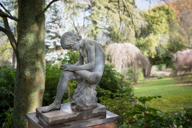 Hepburn Shire Council Art and Heritage Collection
Public Art Work, Boy with a thorn - 'Lo Spinario', c. 1900
Boy with a Thorn Though the classical bronze that the figure was modeled has become known as Lo Spinario, both Stuart Rattle and Kevin O’Neill referred to it as The Boy with a Thorn. Information from the late Stuart Rattle and John Graham, the late Kevin O’Neill’s partner. The statue was bought by Kevin O’Neill from a South Yarra antique dealer in the 1980s. She had bought it in Europe. Stuart believed that it was cast in Berlin by Moritz Geiss who had pioneered the popular process of zinc casting of classical statues. Schinkel, the architect of early 19th Century Prussian public buildings used the process extensively. I assume that the decorations that can be seen in Berlin currently are copies of those copies, given the comprehensive destruction of the city in 1945. Unless there is a date stamped on the statue, and there might well be, there is no firm indication of its age, although Stuart and Kevin believed it was “turn of the century”. It was given to Stuart by John Graham after the death of Kevin O’Neill. Prior to its installation at Musk Farm, it was “by the dam” at Marnarnie, O’Neill’s property at Mt Macedon. It became a much photographed focal point in the sunken garden at Musk Farm. The statue is a gift from the Rattle family to The Friends of Wombat Hill Botanic Gardens who intend to give it, in turn, to Hepburn Shire to be placed in the Botanic Gardens. Both the family and the Friends see it as a memorial to Stuart’s tireless work to raise funds for the Gardens and to raise the profile of the Gardens so that their considerable significance could be more broadly acknowledged. The CMP notes that statuary has been a feature of most botanic gardens (and a notable feature of the Ballarat Botanical Gardens) and James Lowe, the head of Parks for the Shire has also commented that it is an area that could well be developed in the Gardens. This comes from his attendance at meetings of the BGANZ, the “peak professional body” for the development and maintenance of registered botanic gardens in Aus and NZ. Given the lack of funds that the Shire has been able to allocate to the Gardens, a donation of this calibre is a welcome addition to the cultural asset that the Gardens represent. A very large number of residents of the Shire are members of the Friends, have visited Musk Farm and are appreciative of the Gardens. There is a current feeling that the Gardens are undergoing a dynamic revival as a result of the success of the Café and also because of the extraordinary improvement and enhancement of the amenity that has been undertaken over the past two years by the Friends. The installation of the Boy with the Thorn is another move forward for the Gardens. The statue is cast zinc. It is sometimes referred to a white bronze. As can be seen in the photographs, it is in very good condition with no damage or apparent degeneration of the metal. The Smithsonian Institution has a lengthy document relating to the deterioration and repair of similar casts in the US where urban pollution has taken its toll but for the most part it deals with inappropriate repair rather than maintenance protocols. One of the properties of zinc that is appreciated in Australia is its ability to withstand the elements and given that the artwork has been either on Mt Macedon or at Musk for the last 30 years or more, its relocation to Wombat Hill seems to be an appropriate one. The Friends are prepared to organise and pay for the relocation of the statue. The issue of security from the point of view of theft, malicious damage and environmental impact will need to be addressed. The Ballarat Botanical Gardens have recently reinstalled statuary which has been damaged and which had been removed from the Gardens on account of this. They have used Rockworks Ballarat and Wilson’s Memorials to make plinths, secure artworks with steel pins and to provide especially robust fixings to ensure the safety of the various sculptures. The CMP (2007) makes a number of recommendations regarding security in the Gardens ranging from the installation of lighting to the locking of the gates overnight and the repair/reinstatement of appropriate fencing – not done as yet to my knowledge. Paul Bangay has also agreed to act as a consultant in the process of installing the Boy. John Graham estimates its value at $20,000 The preferred location for the work would be at the entrance to the Fernery from the lawn. The paths form an intersection at that point that could be modified to fit the statue. But this is currently a suggested location only. The statue is a gift from the Rattle family to The Friends of Wombat Hill Botanic Gardens who have gifted it to the Hepburn Shire to be placed in the Botanic Gardens. Both the family and the Friends of the Wombat Hill Botanical Gardens Daylesford see it as a memorial to Stuart’s tireless work to raise funds for the Gardens and to raise the profile of the Gardens so that their considerable significance could be more broadly acknowledged. Lo Spinario (Boy with a thorn) c. 1900 copy after the Greco-Roman Hellenistic antique bronze in Rome. c. 1900 copy after the Greco-Roman Hellenistic antique bronze in Rome (Palazzo dei Conservatori, Musei Capitolini, Rome) Manufacturer M. Geiss, Berlin Nonedaylesford, wombat hill botanical gardens, stuart rattle, kevin o'neill, john graham, boy with a thorn, lo spinario, classical sculpture, zinc, classical nude, hepburn shire, public art, sculpture, art -
 Eltham District Historical Society Inc
Photograph - Digital Photograph, Alan King, Eltham Railway Trestle Bridge, 28 December 2007
Covered under National Trust of Australia (Victoria) State Significance and Heritage Overlay, Nillumbik Planning Scheme. Published: Nillumbik Now and Then / Marguerite Marshall 2008; photographs Alan King with Marguerite Marshall.; p103 The Eltham railway trestle bridge is the only one of its kind still regularly used in Melbourne’s metropolitan railway network. Opened in 1902, it is also one of Victoria’s very few timber rail bridges that still carries trains.1 The bridge is part of the railway line extension from Heidelberg - extended to Hurstbridge in 1912. This extension resulted in one of the greatest social changes experienced in Eltham Shire, as it considerably lessened its isolation attracting tourists, artists and suburban commuters particularly after World War Two.2 The bridge has been classified by the National Trust as historically, scientifically, aesthetically and socially significant at state level. But this has not always been recognised, and in 1977, locals fought to save it from destruction. The Victorian Railways proposed to replace the bridge with an earth embankment and large culverts to avoid maintenance problems and fire. This was rejected by the Eltham Council who protested that the bridge helped maintain the area’s rural character, historic link and beauty, as well as avoiding possible serious flooding on the flood plain if a culvert was blocked. The bridge stands as part of a National Trust classified landscape which includes the Alistair Knox Park, named after the local conservationist and architect who helped to make Eltham famous for its mud-brick houses. The landscape includes tall and spreading manna gums and candlebarks, and the historic Shillinglaw Cottage. Artist Walter Withers, one of the Heidelberg School of painters, painted the bridge early in the 20th century. The 38 span single-track railway bridge over creek and road has 34 timber-beam spans and four steel-joist spans, supported by four-pile timber piers and timber abutments. It has almost 200m of timber deck. All of the timbers have been replaced over the years, but the only change to the bridge’s character was the addition of pylons and wiring for electric trains in 1923. A petition for a railway to the shire was first made in 1883. A large deputation of local citizens to the Commissioner of Railways proposed a route passing through Alphington to midway between Greensborough and Eltham up the Diamond Creek valley towards Queenstown and Kinglake. As a result the Princes Bridge-Heidelberg Railway was opened in 1888. From 1888 locals demanded a railway extension. Kangaroo Ground farmers in particular, led by Shire Councillor and Member for Evelyn, Ewen Cameron, said it would assist local farmers and orchardists send their produce to the Melbourne market. In 1890, before the severe economic Depression, an extension of the line to Hurst’s Bridge (now Hurstbridge) was included in a new Railways Bill. The parliamentary delegations were regaled with a banquet at Hurst’s barn and entertained by the Diamond Creek Brass Band, but the extension was abandoned when the Depression struck in 1892-1893. The extension of the railway to Eltham, completed in 1902, was one of the few built in those hard times. That is why the Eltham timber-trestle railway bridge is a rare example of a broad-gauge rail bridge constructed between 1893 and 1910. At the opening, despite persistent drizzle, 300 children waving flags and banners were among the large crowd welcoming the first train, carrying official dignitaries, to Eltham. It had taken 24 years to bring the railway to Eltham. From then Eltham became a popular destination for outings. Mr Orford of Eltham recalled that after the railway came to Eltham ‘the craze for picnics on weekends and holidays began…. During the wattle season, wattle trains came to Eltham frequently. The visitors roamed the creek pulling great armfuls of wattle blossom to take back with them to Melbourne’.3 In 1926 the railway line was electrified as part of the metropolitan rail network. But the Victorian Railways decided not to complete the formerly planned Diamond Valley Railway to Queenstown (now St Andrews) and Kinglake.This collection of almost 130 photos about places and people within the Shire of Nillumbik, an urban and rural municipality in Melbourne's north, contributes to an understanding of the history of the Shire. Published in 2008 immediately prior to the Black Saturday bushfires of February 7, 2009, it documents sites that were impacted, and in some cases destroyed by the fires. It includes photographs taken especially for the publication, creating a unique time capsule representing the Shire in the early 21st century. It remains the most recent comprehenesive publication devoted to the Shire's history connecting local residents to the past. nillumbik now and then (marshall-king) collection, eltham railway trestle bridge, eltham trestle bridge -
 Eltham District Historical Society Inc
Photograph - Digital Photograph, Alan King, The Robins, 13 Kangaroo Ground-Warrandyte Road, North Warrandyte, 2 March 2008
Built by noted artist Theodore Penleigh Boyd, father of architect Robin Boyd. Covered under National Estate, National Trust of Australia (Victoria) Local Significance and Heritage Overlay, Nillumbik Planning Scheme. Published: Nillumbik Now and Then / Marguerite Marshall 2008; photographs Alan King with Marguerite Marshall.; p111 The Robins at Warrandyte,* was once home to a member of a famous family and is also one of the first reinforced concrete houses in Victoria. The builder, Theodore Penleigh Boyd, born in 1890, was a talented painter1 noted for his works of the Warrandyte bush. He was the father of architect Robin Boyd, author of the Australian Ugliness and the uncle of painter, Arthur Boyd. Penleigh Boyd’s great grandfather was Sir William A’Beckett, Victoria’s first Chief Justice. Penleigh Boyd is considered by some to be an ‘unsung hero’ overshadowed by more famous members of his family. Mornington Gallery Director Andrea May said many believed Boyd ‘had never received the national acclaim that he deserved’.2 Classified by the National Trust3 and part of the Australian National Heritage,4 The Robins is set well back near the end of Kangaroo Ground – Warrandyte Road, unobserved by passers-by. Built in 1913, The Robins has some Art Nouveau influences and is a descendant of the Queen Anne style. It is covered in stucco and has a prominent attic, which Boyd used as a studio. Some parts of the house are up to 33 centimetres thick and built in part with pisé (rammed earth) and in part with reinforced concrete. Amazingly, Boyd built The Robins without an accessible driveway, and only a narrow track along which he had to cart building materials. The journey was uphill and Boyd terraced the land with Warrandyte rock5 without the aid of machinery. At only 33 years, Boyd was killed in a car accident in 1923. He was buried in Brighton near the home of his parents. Several people have since owned the house, including political journalist, Owen Webster. Boyd was born at Penleigh House, Wiltshire, and studied at Haileybury College, Melbourne and The Hutchins School, Hobart. He attended the Melbourne National Gallery School and in his final year exhibited at the Victorian Artists’ Society. He arrived in London in 1911 and his painting Springtime was hung at the Royal Academy. He painted in several studios in England and then worked in Paris.6 There he met painter Phillips Fox through whom he met artists of the French modern school and also his wife-to-be, Edith Anderson, whom he married in Paris in 1912. After touring France and Italy, the couple returned to Melbourne. In 1913 Boyd held an exhibition and won second prize in the Federal Capital site competition, then the Wynne Prize for landscape in 1914. In 1915 Boyd joined the Australian Imperial Force, and became a sergeant in the Electrical and Mechanical Mining Company. However he was severely gassed at Ypres and invalided to England. In 1918 in London Boyd published Salvage, writing the text and illustrating it with 20 black-and-white ink-sketches of army scenes. Later that year he returned to Melbourne, and, despite suffering from the effects of gas, he held several successful one-man shows, quickly selling his water-colour and oil paintings. In his short career Penleigh Boyd was recognized as one of Australia’s finest landscape painters. He loved colour, having been influenced early by Turner and McCubbin. His works are in all Australian state galleries, the National Collection in Canberra as well as in regional galleries.7 His wife Edith was also an artist having studied at the Slade School, London, and in Paris with Phillips Fox. After her marriage she continued to paint and excelled in drawing. In later years she wrote several dramas, staged by repertory companies, and radio plays for the Australian Broadcasting Commission, in which she took part. She was the model for the beautiful red-haired woman in several of Phillips Fox’s paintings and the family hold three of his portraits of her. *Possibly named after the Aboriginal words warran, meaning ‘object’ and dyte, meaning ‘thrown at’.This collection of almost 130 photos about places and people within the Shire of Nillumbik, an urban and rural municipality in Melbourne's north, contributes to an understanding of the history of the Shire. Published in 2008 immediately prior to the Black Saturday bushfires of February 7, 2009, it documents sites that were impacted, and in some cases destroyed by the fires. It includes photographs taken especially for the publication, creating a unique time capsule representing the Shire in the early 21st century. It remains the most recent comprehenesive publication devoted to the Shire's history connecting local residents to the past. nillumbik now and then (marshall-king) collection, kangaroo ground-warrandyte road, north warrandyte, the robins -
 Parks Victoria - Point Hicks Lightstation
Lid, ship tank
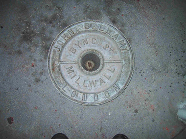
The heavy cast iron, round lid was originally fastened into a large, riveted metal box, known as a ship tank. It has the name ‘John Bellamy London’ cast in capitals in a continuous circle on the outer edge of the lid face, and the words ‘Byng St Millwall’ on the inner circle. , of Millwall, London, manufactured boilers and ship tanks from the 1860s to the 1930s and came from a family of tank makers who began manufacturing tanks some time before 1856. Ship tanks were invented in 1808 by notable engineer, Richard Trevithick and his associate John Dickinson. Their patent obtained the same year described the tank’s superior cubic shape that allowed it to fit squarely as a container in vessels and thus use space efficiently, while its metal fabric preserved and secured its liquid or solid contents from damage. The containers revolutionised the movement of goods by ship and made wooden casks redundant. Research by Michael Pearson has determined that they were carried on passages to Australia from at least the 1830s conveying ships’ victuals and water storage, as well as general goods heading for the colonies. Pearson found photographic evidence of their use in the 1860s, and by the 1870s they appeared to be in common use. lids surviving from containers indicate that nearly all the tanks transported to Australia came from London manufacturers. It was usual for the brand name to also feature as a stencil on the tank but in most cases this eventually wore off. A tank without its original stencil survives at Wilsons Promontory. Tanks transporting ‘drinking water or perishable dry goods were hermetically sealed by the use of the tightly fitting lid with a rubber sealing ring ‘which was screwed tight with the aid of lugs cast into the lid and wedges cast into the rim of the loading hole’. The raised iron rod welded across the outer face of many lids such as the Bellamy example, allowed for screwing the lid tight. Once in the colonies, the ship tanks were often recycled and adapted for many resourceful uses such as packing cases, dog kennels, water tanks, oil containers and food stores and this invariably led to the separation of the lid and tank. The Bellamy lid could have been salvaged from a shipwreck but is more likely to have to have originated from a recycled tank that was brought to the lightstation for water storage purposes. Pearson writes that: Ship tanks show up at a wide range of sites, many of them isolated like lighthouses. They were, I think, usually taken there for the purposes they filled, usually water storage, as they were readily available, relatively light to transport, and probably very cheap to buy as second-hand goods containers. In rural areas they may have been scavenged for their new uses from local stores, to whom goods were delivered in them. Parks Victoria has identified five tank lids in the lightstation collections covered by this project. In addition to the Bellamy lid at Point Hicks, they include a Bow brand lid at Point Hicks and another at Cape Otway, unidentified lids at Cape Otway and Wilsons Promontory. Pearson and Miles Lewis have each recorded two versions of the Bellamy trade name on the lids; one being ‘John Bellamy Byng St. London’; the other, ‘John Bellamy Byng St. Millwall London’. The Point Hicks lid has the second version of the name, as do other examples in Victoria that Lewis has identified at Illawarra, Toorak; Warrock homestead, Casterton; Eeyeuk homestead, Terang; Ward’s Mill, Kyneton; and Boisdale homestead near Maffra, and in NSW at Ayrdale Park, Wolumla; and Bishop’s Lodge, Hay. Pearson’s list includes the same lids in NSW at Tumbarumba; the Quarantine Station, Sydney; Willandra Station; Bedervale, Braidwood; Gunnedah Museum; Walla Walla and Macquarie Island. The Point Hicks lid is currently stored in the lighthouse although it is unlikely that its use had any association with this building. The lid is in good condition and retains the central bung. Pearson notes that ‘surviving lids are far less numerous than the tanks themselves, presumably because the uses to which the tanks were put did not require the lid to be retained’.347 The Bellamy ship tank lid has first level contributory significance for its historic values. Circular cast-iron disc with raised outer ridge with inscription. It also has an inner depression with inscription. Two metal sections form handles over inner depression. Hole in middle of disc.Around perimeter of outer edge "JOHN BELLAMY LONDON" Around inner area "BYNG ST MILLWALL" -
 Melbourne Legacy
Document - Speech, ANZAC Commemoration Ceremony for Students
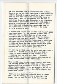
A copy of an Anzac Day Address at the Anzac Commemoration Ceremony for Students, the year is unknown but it is presumably the address given by the President of Legacy. It seems to be one of the earlier ceremonies. It was stored with documents about the building of the Shrine and another speech from the 1939 service. The presenter had probably served in World War 1 so was very close to the events he was talking about. The ceremony provides a valuable opportunity for students to gain an appreciation of the Anzac spirit, the significance of the Shrine and the meaning of Anzac Day. The ceremony is usually attended by representatives from schools throughout the state and the Governor of Victoria. The text says: 'We have gathered here too commemorate the historic landing on the Gallipoli Peninsula of the Australian and New Zealand troops on the 25th of April 1915 - the day that has come to be universally known as Anzac Day. . . I expect most of you know how the word 'Anzac' came into being. How General Birdwood and his officers took the first letters of the words Australian and New Zealand Army Corps and formed them into the code word "Anzac". They did not expect it would become the famous name by which the men fighting under them would become known. But it did, and Anzac Day has become Australia's greatest national day because on that day Australia's manhood was put to its first great test. You see up to that that time, the world knew very little about us. We had not, thank God, ever had to fight for the existence of our Nationhood and everything we hold most dear. Everyone wondered how our men would compare with the men of other nations when a real crises arose. . . . You have been told there thrilling story of Anzac Day. Of the landing at dawn on that terrible coast: the hand to hand fighting that went on continuously all that day and through the days and nights that followed. How the Anzacs - outnumbered, exhausted and tortured by thirst held on, and how during the terrible nine months that ensued all the efforts of a brave enemy to dislodge them failed. Such was their gallantry that a British Officer described the Australian soldier as "The bravest thing God ever made". What a wonderful tribute that was; and how proud we should be of the men who earned it. . . . These men carried on all the traditions of the Anzacs and made a wonderful name for Australia and New Zealand in France, in Belgium, in Egypt and Palestine and in all the theatres of war in which they served. And this great Shrine was build by the people of Victoria, not in any boastful sense of Victory, not in any attempt to glorify war - which is a horrible, dreadful thing, but in memory of those thousands of Victorian sailors and soldiers who so loved their country that they laid down their lives in her service. . . All of them were brave, but do not think that a soldier who is brave need alway be a great warrior. I hope when you have passed through the Shrine you will go and see a little bronze statue near the road yonder. A statue of a man leading a donkey which carries a wounded comrade. You will see the soldier leading the donkey carries no weapons. Yet he was a hero indeed, for he saved the lives of scores of his comrades at Anzac by carrying wounded from the battle to safety and the hospital. And in the end he too gave his life for his friends. . . Let us all try to help each other in peace as they did in war. Instead of divisions, let us have unity. If we think of no one but ourselves we shall not achieve anything nor shall we deserve to. Let those of you who are strong help those who are not so strong - all through life - like John Simpson, the man with the donkey did. Be proud of your country and do nothing to dishonour it. If you get an order from one in authority, obey it, even if you do not understand it.A good solider always obeys his orders. If he did not, he may bring disaster and cause harm to his fellow soldiers. Remember that those thousands of men died so that we could still live here in freedom. A country is judged by its citizens. Let us be worthy of those great citizens who have left us the legacy of their fame and devotion to duty. And when you file through the Shrine and look down on the Rock of Remembrance, read the inscription on it, "Greater Love Hath No Man", remember those wonderful words written in the greatest book in the world nearly two thousand years ago, "Greater love hath no man than this, that a man lay down his life for his friend."A record of a ceremony at the Shrine for school students. The text of the speech is significant in that it was written by a man who had served in World War 1 and knew first hand what it meant to be part of the first Anzacs. White quarto paper x 4 pages with black type of a speech at one of the Annual Anzac Commemoration Service for Students.Handwritten in blue pen 'Shrine, Children's Service'anzac commemoration for students, wreath laying ceremony, speech -
 Flagstaff Hill Maritime Museum and Village
Weapon - Historic Rifles, Royal Small Arms Factory, 1877-1900
Martini-Henry Artillery Carbin rifles were made by the Royal Small Arms Factory at Enfield, Britain, from 1877 until 1900. Many were distributed to the British Colonies, including this pair, which was allocated to the Woodford Police, Victoria Police District of Warrnambool, Southwest Victoria. The Carbine model rifles were shorter than the standard rifles and more suited to mounted police and troopers. It is likely that in the early 20th century, Victoria Police replaced the two carbines with more modern firearms, and the outdated guns were stored in the stables. The rifles were left there and likely forgotten about due to changes in police staff. In 1915, police authorities announced that they would be replacing patrol horses with bicycles and would also close some smaller police stations. This affected Woodford Police Station, which closed in 1917. The forgotten firearms remained in the stables and were noticed by schoolboy Robert Jellie in 1940 and seen again in 1946. In 1995, the property was sold by the Education Department to a private owner. The Woodford Community donated the pair of Martini-Henry Carbines to Victoria Police Museum in the late 1990s for mounting and display, which was funded by the Victoria Police Historical Society Inc. The decorative wood and glass display case and frame were designed to preserve the significant history of the guns. On November 1st 1999, the display was presented to Warrnambool Police and the local community due to the historical significance of the Woodford Police Station. On March 10th, 2025, the display was transferred to Flagstaff Hill Maritime Museum and Village, where the historical story of the Martini-Henry Carbines could continue to be preserved and accessed by local families, the community, visitors to the area, and online visitors. WOODFORD POLICE: - The small settlement at Woodford was established in the 1840s around the Merri River where there was a ford across the water and, from 1848-1851, a bridge. The area was settled very early in Victoria’s history and the river crossing provided travellers with access to the early route between Port Fairy (name Belfast at that time), Warrnambool and Melbourne. Occasionally a Warrnambool police trooper would ride through Woodford and district. In December 1854, Woodford Police barracks and stables were built on the hill by the Merri River on Bridge Road east where Jubilee Park now stands. A local mounted trooper kept law and order in the area. In 1856, a lock-up was installed, and the first Woodford Police Station was in action in 1857. By 1871, the police station had been moved from the hill to land across the Merri River bridge, on the southern side of Bridge Road west, near Mill Street. In 1890, the police residence there was replaced by a stone Edwardian-style building with the stables and lock-up behind it and the old police station at the rear. The police continued to have a presence in Woodford until it was closed by the Police Commissioner in July 1917 for economic reasons. The residence was used for government housing until 1923, when it was taken over by the Education Department for the school teacher’s home. In 1995, it became privately owned. THE MARTINI-HENRY ARTILLERY CARBINE: - The Martini-Henry rifles were made in Britain from 1871 at the Royal Small Arms factory at Enfield and were stamped with the symbol of the Royal Cipher (Crown over VR) over ENFIELD to identify their origin. They were named after two of several people who helped design this method: Swiss Friederich von Martini and Scotsman Alexander Henry. The design was breach-loaded, and the inner barrel was rifled. A thumb rest was incorporated into the top right of the bullet receiver’s chamber. The small teardrop lever on the right side of the rifle showed whether the rifle was ready to be shot. In 1877, the shorter, lighter weight Carbine version of the firearm was produced for mounted troops and artillery. Its official name was “Carbine, B.L., Rifled, Martini Hanry.” The bullets were slightly lighter in weight than those used for the longer rifle. The sight position was adjusted for the shorter gun, and wings were added to the sight on the tip, making it easier to slide the rifle back into a saddle bag. Some of the later Carbines also had leather sight covers screwed to the stock to prevent them from catching on the saddle bags. The Carbines had accessories available, such as barrel extensions with bayonets and swivels for adding slings. The Martini-Henry Carbine designs were later modified to fire the British .303 ammunition. Eventually, by 1900, the Martini-Henry Carbines were replaced by the Lee Enfield gun design. The pair of Martini-Henry Carbine firearms represents policing in the early pre-1900 days of colonial settlement; Woodford was one of the first townships settled in Victoria, and it had a police presence from 1854 until 1917. The rifles and display provide a historic connection between the location of Woodford and relatives and associates. The carbine rifles show a stage in the evolution of weapon design, adapted to suit mounted troops, and adding features to streamline use and storage. The ammunition was also improved during this progression. The carbines are important for their connection to policing law and order in a remote area. They are significant for their association with the township of Woodford, which was important to travel in the southwest Victoria district, providing access across a river for a road between Port Fairy and Melbourne, and later Warrnambool, and supplying food, goods and accommodation for the travellers. A pair of mounted rifles is mounted behind glass in a timer case, accompanied by a framed display of two photographs and an account of the rifles’ history. The case and display each have a horizontal board with a gently curved edge and carved decorations added. The identical firearms are British-made Martini Henry Carbine breach-loaded rifled guns, supplied by Britain to its Colonial troops from around 1877. The rifles are lever-action, single-shot .500 calibre weapons. They have a teardrop lever on their right side. They were used by Victoria Police mounted troops at the Woodford Police Station, Victoria. The black and white photographs were taken in 1946. The left photograph has a circled area; the right photograph is an enlarged view of the circled area, showing the Woodford Police Station in detail. The printed text is on textured paper with the Victoria Police watermark. It gives a summary of the rifle’s history. There is an inscription on the left photograph. Left photograph, handwritten in white pen: “WOODFORD” Document’s print: “During the late 1840s the small town of Woodford grew around the crossing of the Merri River on the Melbourne/Port Fairy Rad. Woodford was proclaimed a township in 1854 and a police quarters was established there in 1857. The police station remained until 1917 when it was closed and police service from then on was provided from Warrnambool. The building was then used as a school residence and is now privately owned. In !940 Robert JELLIE, then a schoolboy, observed two rifles mounted on the wall of the disused stable at the rear of the old police building. Following the devastating flood of 1946 (see photograph above) the rifles were again seen in the room next to the stable but were not seen again until the building was sold by the Education Department many years later. It was a recognition of the historical value of the rifles which led to their donation to the Warrnambool Police Complex. The rifles have been authenticated by the Victoria Police Armoury as being Victoria Police issue some time before 1900. The rifles are an identical pair of the famous British-made Martini Henry, a .500 inch calibre military weapon widely used by British Colonial troops. Victoria Police and the wider community of Warrnambool are indebted to the members of the Woodford community for their fine gesture in donating the rifles for mounting so that their historical importance can be preserved and they can be displayed for generations to come. This display was funded by the Victoria Police Historical Society Incorporated, and presented on the first day of November, 1999.”flagstaff hill maritime museum and village, great ocean road, shipwreck coast, martini henry, victoria police, woodford police station, rifle, carbine, display case, british, martini henry carbine, breech-loaded, rifled, colonial, single-shot, .500 calibre, weapon, gun, 1877, troops, mounted troops, merri river, victoria police woodford, victoria police warrnambool, victoria police melbourne, police quarters, robert jellie, school residence, stable, 1946 flood, victoria police armoury, identical pair, british colonial troops, victoria police historical society incorporated, woodford, bicycles, found by a schoolboy, edwardian-style building -
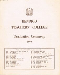 Bendigo Historical Society Inc.
Document - LA TROBE UNIVERSITY BENDIGO COLLECTION: BENDIGO TEACHERS' COLLEGE GRADUATION CEREMONY 1960
A cream document titled "Bendigo Teachers' College Graduation Ceremony 1960". The front page also contains a list of the staff working at the college. They are Mr. S. H. Walters (Principal), Miss J. C. Burnett, Mrs. N. F. Fawdry, Mrs. F. M. Petri, Miss R. E. Manlein, Mrs. D. J. Andrew, Mrs. B. F. Hughes, Miss K. Alexander, Miss C. M. Oughton Jones, Miss B. H. Cowling, Mrs. A. J. Coleman, Mr. F. M. Courtis, Mr. D. A. Newbury, Mr. F. X. Martin, Mr. C. L. Barker, Mr. T. J. McCabe, Mr. F. G. East, Mr. P. F. Fitzpatrick, Mr. M. Pratt, Mr. W. J. F. Bernoth, Mr. R. L. Strauch, Mr. M. A. James, Mr. R. E. Wittman, Mr. C. F. Houston, Mr. J. R. R. McLeod, Mr. G. G. Woodfield and Mr. K. C. Coles. The inside cover contains the "Significance of the Ceremony" and "Order of the Ceremony". Mr. F. M. Courtis welcomed the visitors whilst the Principal read the College Charge. The 'Graduation Book' was presented to Mr. A. L. Harris Inspector of Schools by Miss J. C. Burnett.The final roll call for 1960 was read by Mr. C. L. Barker. Congratulations were offered by The Mayor of Bendigo Cr. R. H. Wilson,J. P., Cr. T. A. Drechsler President of Strathfieldsaye Shire and Mr. G. Salathiel, Head Teacher of Gravel Hill State School. Finally the Occasional Address was presented by Mr. F. H. Brooks Assistant Director of Education. The following page contains a list of "Students of 1958-1960 Trained Infant Teacher's Certificate" - Marjorie May Allen, Janice Helen Ashman, Grada Ali Bos, Joan Margaret Busfield, Barbara Joan Cameron, Shirley Margaret Cribbes, Marcia Ann Davison, Margaret Mary Frances Dick, Lorraine Jean MacIntosh Goddard, Beverley Lorraine Goudie, Jennifer Joy Hamilton, Maureen Margaret Hunt, Shirley Joyce Innocent, Monica McKenna, Eileen Bernadette Mulvahil, Nola Ellen Parker, Jeanette Mary Pearson, Maureen Anne Pentland, Elaine Denise Pochon, Marian Judith Rechter, Marilyn Joy Rose, Catherine Shiels, Margaret Evelyn Stevenson, Rosemary Sutherland, Patricia Helen Tassicker, Eileen Monica Tuohey, Robin Elizabeth Walters, Patricia Ann Wenn and Ethel Dawn Whitelock. The back page contains a list of "Students of 1959-1960 Trained Primary Teacher's Certificate". - Kathleen Anne Algie, Ian Armstrong, Lorna Constance Barbour, Ronald Lindsay Bell, Michael Laurence Brown, Ross Ernest Brown, Graeme Lambden Budd, Duncan Leslie Thomas Cameron, Peter Morgan Clutterbuck, Joan Christine Connor, Allen William Cornelius, Glenys Elaine Cussins, Jean Elizabeth Davis, Denis William DeCann, Robert Alain Denham, Janet Carmel Doyle, Patricia May Edwards, Walter Kenneth Espagne, Fay Iris Evans, Brenda Gertrude Farrell, Malcolm George Ferguson, Elizabeth Joyce Fitzgerald, Kevin Joseph Foley, Barbara Violet Forrester, Lawrence Joseph Ginnivan, Peter Murray Graham, Thelma Elaine Grist, Dorothy Robyn Haines, William Jon Hall, Patricia Jeanette Hancock, Robert John Harris, William Ian Hart, Lorraine Moira Holmes, Lynette Ann Ireland, Morris Raymond Jackman, Christine Jackson, Margaret Nancy Jackson, Nanette Elizabeth Johnson, Trevor John Kellam, Robert Bruce Kemp, Ross Eliot Koochew, Henry Francis Lean, Janet Bobbie Leabeter, Rosemary Elizabeth Lowe, Graeme Stanley Lucas, Joy Patricia Maxwell, Terence Michael Mulvihill, George Alan Murdoch, Kevin Michael Murphy, Ann-Marie McCallum, Helen June Nixon, Kerry Joy O'Brien, William John O'Connell, Christine Lynette Olsen, William Stanley Page, Janice Anne Preston, John Stuart Reed, William Francis Reeves, Gary Desmond Robbins, Peter John Schlitz, Donald John McIntosh Shadforth, Gavin James Smith, John Archibald Spark, Illar Streimann, Janice Margaret Taylor, Ian Leonard Thornton, Rosemary Fay Wait, Russell Gilbert Walker, James John Wallis, Clare Mary Ward, David Ross Wiedermann, and Stephen Wilkinson.bendigo, education, bendigo teachers' college graduatio, la trobe university bendigo collection, collection, bendigo teachers' college, bendigo, education, teaching, teachers, students, graduation, tertiary education, graduation ceremony, history, book, bendigo teachers' college staff, graduands, graduates, bendigo teachers' college students, teacher training -
 Eltham District Historical Society Inc
Photograph - Digital Photograph, Marguerite Marshall, Wingrove Cottage, Main Road, Eltham, 8 June 2006
Wingrove Cottage built 1858-1859 of hand made bricks is historically significant for its long association with Charles Wingrove, a prominent figure in Victorian local government, as secretary to the Eltham District Road Board and Shire Council from 1858 to 1904, and Shire Engineer and Secretary to the Heidelberg Road Board. The cottage was used as the office of the Eltham District Road Board and Council for many years It is one of the Shire's oldest dwellings, and one of the few surviving 19th century buildings associated with early Eltham and located in the original Eltham Village Reserve. The symmetrical planting of a pair of Pencil Pines (not visible in photo) is also historically and aesthetically significant as characteristic of the early period of planting in the district and because they are a distinctive landscape feature. In October 2002 new owners demolished the outbuildings attached to the rear of the cottage. Community protest at the demolition resulted in Council issuing a Stop Work order. The owner was issued with a court order in September 2003 to develop a conservation management plan and restore the heritage listed property. The owner sold the property in 2005 to Cameron Construction in 2005 who undertook the restoration work. In 2007 a planning application to build two offices and seven dwellings at the rear of the property was ultimately rejected. The cottage is now the main office for Cameron Construction. Covered under Heritage Overlay, Nillumbik Planning Scheme. Published: Nillumbik Now and Then / Marguerite Marshall 2008; photographs Alan King with Marguerite Marshall.; p57 Wingrove Cottage on Main Road beside Eltham Primary School, is one of the Shire’s most important historical buildings and was central to local government for almost 50 years. The cottage was built in stages from 1858 to 1888 for Charles Symons Wingrove JP. He was the Eltham District Road Board’s first paid secretary and later the Shire Secretary when the board became the Eltham Shire Council. Wingrove held those positions, and that of engineer for a time, for 46 years. He was also one of the main figures in the Municipal Association of Victoria. As Eltham’s first paid municipal officer, Wingrove used one room in his 11 – (originally two) roomed home, as the office for the board then the council. Meetings were held there from the late 1850s (as well as at more central locations) until Wingrove’s retirement in 1904. The cottage is a rare example of a local government office occupying a Road Board /Shire Secretary’s purpose-designed house. The cottage is also significant because it is the oldest largely intact building from the original Eltham township reserve (south of Dalton Street).1 The township had its origins in the 1848 Nillumbik Parish Plan and was one of the state’s earliest township reserves. The rectangular house of handmade bricks, roofed with grey slate tiles and with a veranda encompassing three sides, is reminiscent of those in the central goldfields including Castlemaine. Its overhanging eaves and gables were unlike houses in Melbourne at the time. Wingrove, who was born in 1827, had been a gold digger and a road surveyor. Impossible to imagine in today’s world, Wingrove was also the Shire of Heidelberg’s secretary and engineer for part of the time that he was secretary in Eltham. Living next door to the primary school was a mixed blessing. Wingrove and his wife Katherine, who had ten children, sent their eight surviving children to the school. But they had occasional disputes with the school authorities when their cattle wandered into the schoolyard. Eltham showed Charles Wingrove its appreciation of his services by giving him two illuminated addresses, one after ten years and the other at retirement. Wingrove died in 1905 aged 76 and was buried in the St Katherine’s Church of England cemetery in St Helena. His grave is surrounded by those of family members including his wife, Katherine and two babies, Henry, 12 months and Isobella, 15 months, who died in the mid-1860s. Cottage ownership passed to his wife, then to daughter Caroline and then to daughter Bessie, a Melbourne University graduate and artist. During the Great Depression their brother Walter was the ratepayer. At one stage the Wingrove property extended to Metery Road and included a small creek. The family ran a small dairy and orchard, with associated farm buildings, which were later removed. In 1949 part of the property was compulsorily acquired by the Eltham Primary School, which infuriated owner Bessie Wingrove. She protested in a letter about this ‘monstrous act of unmitigated tyranny’.2 She was the last Wingrove to occupy the cottage and died in 1955. Wingrove descendants sold the house in 1974 and the property was subdivided. In the 1960s the Eltham Shire named the park opposite the cottage in Wingrove’s honour. The cottage has since had several owners including psychiatrist Dr Daniel Kahans, who practised there. In October 2002 late rear additions which had been substantially altered were demolished contrary to council planning controls. This caused a community outcry and resulted in legal proceedings against the owner. Fortunately the historical significance of the demolished section was not as great as the older front part of the building, which has been retained and was later restored.This collection of almost 130 photos about places and people within the Shire of Nillumbik, an urban and rural municipality in Melbourne's north, contributes to an understanding of the history of the Shire. Published in 2008 immediately prior to the Black Saturday bushfires of February 7, 2009, it documents sites that were impacted, and in some cases destroyed by the fires. It includes photographs taken especially for the publication, creating a unique time capsule representing the Shire in the early 21st century. It remains the most recent comprehenesive publication devoted to the Shire's history connecting local residents to the past. nillumbik now and then (marshall-king) collection, cameron construction, charles symons wingrove, eltham, eltham road district board, eltham shire council, main road, wingrove cottage -
 Eltham District Historical Society Inc
Photograph - Digital Photograph, Marguerite Marshall, Alan Marshall by Marcus Skipper (1995) outside Eltham Library, Panther Place, Eltham, 11 October 2006
Sculture in bronze of Alan Marshall by Marcus Skipper, 1995 Alan Marshall, AM., O.B.E., Hon.LL,D. (1902-1984) was born at Noorat, Victoria and became one of Australia's most famous authors. His association with the Eltham area began in 1920 when he started his first job as a junior clerk at the Eltham Shire Offices, Kangaroo Ground. In the 1940's he spent some time living at Research. From 1955 he lived in Eltham for nearly 20 years. Disabilities resulting from polio as a young child did not prevent a wide range of experiences. Alan's occupations have been listed as clerk, night watchman, fortune teller, freelance journalist and author. He has been patron of many disadvantaged Children's Societies. Alan's books are numerous and include novels, short stories, children's books, history and travel. Among the best known are his autobiographies "I Can Jump Puddles" and "This is the Grass". Others include "These are My People", "Ourselves Writ Strange", "People of the Dreamtime"; "The Gay Provider" and "Wild Red Horses". In 1971 he wrote the Centenary History of the Shire of Eltham, "Pioneers and Painters". Covered under National Trust of Australia (Victoria), State significance. Published: Nillumbik Now and Then / Marguerite Marshall 2008; photographs Alan King with Marguerite Marshall.; p159 Outside the Eltham Library a bronze figure of a short one-legged man with a crutch invites people to the world of literature. The bronze statue, by Marcus Skipper, is of author Alan Marshall, who is famed for his autobiography I Can Jump Puddles, about growing up and overcoming the effects of polio. That plucky little boy later lived in the Nillumbik district for more than 50 years, and on his death in 1984, was buried in the Nillumbik Cemetery at Diamond Creek. Although a hugely successful author, his grave is modest with only a tiny boulder and simple bronze plaque on a grassed plot. From 1955 to 1972 Marshall lived in a tiny fibro-cement bungalow at the rear of a house at Park West Road, Eltham, owned by his older sister, Elsie McConnell. It was there that he wrote most of his autobiographical trilogy and his history of the former Eltham Shire, Pioneers and Painters. His long association with Eltham Shire began in 1918 when his family moved to Diamond Creek. Then in 1920 he began work as a junior clerk at the Eltham Shire Offices on Main Road, Kangaroo Ground near the Yarra Glen Road, while boarding at the hotel next door. Marshall later bought a block of land in Research, which had three bark huts. In one of these he wrote his first book These Are My People. He later sold the land but lived in a caravan there and in 1955 wrote I Can Jump Puddles.1 Proud of its citizen, the Eltham Shire named a park after Marshall at the corner of Main Road and Leanne Drive, Eltham. In 1985 the Shire initiated the Alan Marshall Short Story Award. It was Marshall’s early life in the country that taught him to live courageously in spite of his crippling polio, and he inspired many. This informed his writing – full of courage, championing the battler and love of the bush. Alan Marshall was born in 1902 at Noorat in Western Victoria, as the only son of Billy a drover, horse breaker, hawker and then general store owner. At the age of six, Marshall contracted infantile paralysis and was later hospitalised in Colac for 18 months. With his father’s encouragement, Marshall learnt to swim, wrestle and box, ride a bicycle (downhill), ride a horse and drive a car. Marshall won a scholarship to Stott’s Correspondence College to study accountancy. To help him continue his studies and find employment, his family bought 12 acres (4.8ha), in Ryans Road, Diamond Creek, opposite Windmill Court. There they ran cows, some poultry and an orchard. But life with a disability and during the Depression was hard for Marshall, who for 20 years, endured long periods of unemployment and loneliness and was often exploited at work.2 However, life improved in the 1930s, when he published short stories and articles in newspapers and magazines, including a column of advice to the lovelorn, which he wrote for nearly 20 years. At age 42 Marshall published his first book and in the next 30 years he published more than 20. His most successful book was I Can Jump Puddles, which sold more than three million copies internationally. It was made into a film, released in 1971, by Czechoslovakian director Karel Kachyna. Marshall was one of the first Australians to write about Aborigines who called him Gurrawilla - teller of tales - when he lived with them in Arnhem Land for eight months.3 In 1941 Marshall married Olive Dixon, with whom he had two daughters, Catherine and Jennifer. Marshall and Olive divorced in 1957. In 1972 Marshall was awarded an OBE for his work with the handicapped. He was also awarded an Honorary Doctor of Laws by Melbourne University, an Order of Australia for services to literature and the Soviet Order of Friendship of Peoples.This collection of almost 130 photos about places and people within the Shire of Nillumbik, an urban and rural municipality in Melbourne's north, contributes to an understanding of the history of the Shire. Published in 2008 immediately prior to the Black Saturday bushfires of February 7, 2009, it documents sites that were impacted, and in some cases destroyed by the fires. It includes photographs taken especially for the publication, creating a unique time capsule representing the Shire in the early 21st century. It remains the most recent comprehenesive publication devoted to the Shire's history connecting local residents to the past. nillumbik now and then (marshall-king) collection, alan marshall, art in public places, eltham, eltham library, marcus skipper, panther place, public art, sculpture -
 Eltham District Historical Society Inc
Photograph - Digital Photograph, Alan King, St Andrews Anglican Church, St Andrews, 30 January 2008
Built c.1868, St Andrew’s Anglican Church is Nillumbik Shire’s oldest timber church and is historically, socially, and spiritually significant to the Shire of Nillumbik. The church is historically significant because it may have given its name 'St Andrews' to the town (another suggestion is that the name came from the local hotel), it is also historically significant as one of only four buildings that remain from the Caledonian goldfields era of Queenstown (now St Andrews) and one of only a handful of buildings that survived the 1960s bushfires. The church is historically, socially, and spiritually significant because it has played an important part in community life for more than 150 years; a proposal to move the church in 1984 met with strenuous opposition. Much of the fires on Black Saturday 2009 were the north of the town. The town itself remained intact - as did this heritage building. Covered under Heritage Overlay, Nillumbik Planning Scheme. National Trust of Australia (Victoria) Local significance Published: Nillumbik Now and Then / Marguerite Marshall 2008; photographs Alan King with Marguerite Marshall.; p69 The St Andrews Anglican Church and former St Andrews Primary School, are two reminders of the district’s early days, when it was founded on gold. St Andrews, then called Queenstown, was the earliest goldfield in the Caledonia Diggings.1 It was the Upper Diamond Gold Mining and Administrative Centre, with 3000 miners. Queenstown was also the seat of the Court of Petty Sessions. The church and school then stood close to European and Chinese stores, three hotels, a brewery and a quartz mill.2 In 1861, Queenstown was officially proclaimed a township. From 1865, the name Queenstown was interchangeable with St Andrews, until 1952, when the town was officially named St Andrews. As gold declined from the early 1880s, Queenstown changed dramatically into a settlement of small farms. St Andrew’s Anglican Church, built in 1868, is the Shire’s oldest timber church and possibly gave its name to the township.3 The small timber church was opened on November 1, 1869, by the Dean of Melbourne. Anniversary tea meetings helped raise funds, and in 1889, a three-bedroom parsonage was built alongside. In 1910, the vicar, the Rev Selwyn Chase (and friend of the Scouting Movement’s founder, Baden Powell), established the 1st Queenstown Scout Troop, only two years after Scouting began in Australia. The church was important to the lives of many local residents who were baptised, married and had funeral services there. But by the 1950s the population had decreased and so did the weekly attendances. Around the mid-1960s the church closed, then fell into disrepair. So in the mid 1980s it was sold to the Education Department and was under threat of relocation or demolition. However this caused such opposition from locals,4 that instead, the Anglican church leased it as part of the Panton Hill parish5 and it was reconsecrated in 1987. Queenstown’s first school was held in a tent after transferring from Andersons Creek, Warrandyte.6 From 1858 a church school, Caledonia Diggings, stood west of the main road, a quarter of a mile (0.4km) before Buttermans Track. In 1882 the school was moved from a leased building, owned by headmaster Robert Harris, into a larger building on the corner of the School and the Heidelberg-Kinglake Roads. It had been moved from Smiths Gully and included a teacher’s three-roomed residence.7 In 1887 the school was replaced by the Queenstown State School No 128, although it was also called Caledonia Diggings until 1891. In 1956 it was renamed St Andrews. Still standing, this building is now used as the St Andrews Community Centre and the residence is leased for private use. The original timber-lined room remains alongside the extensions, and is distinctive with its high ceiling and tall small-paned windows. In 1984 a new school was built 500 metres west of the old school. Many residents have contributed much to St Andrews but one family that has done so for several generations is the Harris family. Robert Harris was an active member of the St Andrew’s Anglican Church, and worked hard at improving the town’s amenities until his death in 1887. He was a signatory to the successful 1863 petition to the Chief Commissioner of Police, against the proposed removal of the Court of Petty Sessions and police station at the Caledonia Diggings. The police station stayed in the town until 1917. Harris was Head Teacher of Queenstown State School from 1864 to 1874, then of the Smiths Gully school until it closed in 1882, and he continued teaching at Panton Hill until his death. His son, Robert Charles Harris, was editor and printer of the local newspaper, The Evelyn Observer, from 1873 until 1915. Robert’s son, William Shelley Harris, served in the Boer War and in World War One. In 1928 he became Kinglake National Park’s first park ranger. Robert’s daughter Elizabeth, taught needlework at Queenstown State School, and later ran the post office in Kinglake.This collection of almost 130 photos about places and people within the Shire of Nillumbik, an urban and rural municipality in Melbourne's north, contributes to an understanding of the history of the Shire. Published in 2008 immediately prior to the Black Saturday bushfires of February 7, 2009, it documents sites that were impacted, and in some cases destroyed by the fires. It includes photographs taken especially for the publication, creating a unique time capsule representing the Shire in the early 21st century. It remains the most recent comprehenesive publication devoted to the Shire's history connecting local residents to the past. nillumbik now and then (marshall-king) collection, st andrews, st andrews anglican church -
 Eltham District Historical Society Inc
Document - Binder, Eltham Justice Precinct, 1969-2020
EDHS_04863 - Binder: Eltham Justice Precinct 1. Courthouse 1. Eltham Courthouse interesting facts 2. Plan and elevation drawings 3. Other courthouse plans and fittings 1880s – Brunswick, Maffra, Dunolly , Sunbury, Landsborough and Wodonga 4. Newspaper articles: i. ELTHAM POLICE COURT. (1892, April 1). Evelyn Observer, and South and East Bourke Record (Vic. : 1882 - 1902), p. 2 (MORNING.). Retrieved July 5, 2022, from http://nla.gov.au/nla.news-article60667022 ii. BREAKING A PUBLICAN'S LEG. (1900, July 13). Evelyn Observer, and South and East Bourke Record (Vic. : 1882 - 1902), p. 2 (MORNING.). Retrieved July 5, 2022, from http://nla.gov.au/nla.news-article60688367 iii. ELTHAM COURT. (1901, March 1). Mercury and Weekly Courier (Vic. : 1878 - 1903), p. 3. Retrieved July 5, 2022, from http://nla.gov.au/nla.news-article58578953 iv. ANNIE CHASES A TINKER. (1902, October 3). Evelyn Observer, and South and East Bourke Record (Vic. : 1882 - 1902), p. 2 (MORNING.). Retrieved July 5, 2022, from http://nla.gov.au/nla.news-article64029968 v. ELTHAM POLICE COURT. (1927, May 6). Advertiser (Hurstbridge, Vic. : 1922 - 1939), p. 4 (AFTERNOON). Retrieved July 5, 2022, from http://nla.gov.au/nla.news-article57754748 vi. ELTHAM POLICE COURT. (1927, May 20). Advertiser (Hurstbridge, Vic. : 1922 - 1939), p. 3 (AFTERNOON). Retrieved July 5, 2022, from http://nla.gov.au/nla.news-article57754814 vii. Eltham Police Court (1931, January 9). Advertiser (Hurstbridge, Vic. : 1922 - 1939), p. 4. Retrieved July 5, 2022, from http://nla.gov.au/nla.news-article56734073 viii. Repairs to Eltham Police Station, The Advertiser (1929, May 24). Advertiser (Hurstbridge, Vic. : 1922 - 1939), p. 2 (AFTERNOON.). Retrieved July 5, 2022, from http://nla.gov.au/nla.news-article57759907 ix. ELTHAM COURT. (1929, August 2). Advertiser (Hurstbridge, Vic. : 1922 - 1939), p. 4 (AFTERNOON.). Retrieved July 5, 2022, from http://nla.gov.au/nla.news-article57760345 x. See also Trove list https://trove.nla.gov.au/list/116634 5. Letter: Shire of Eltham Historical Society to Shire of Eltham, 1 July 1969 regarding potential replacement of Eltham Courthouse and the building’s historical significance and acknowledgement 10 July 1969 6. Letter: Shire of Eltham Historical Society to Law Department, 26 May 1972, re preservation of Eltham Courthouse and potential classification and acknowledgement 7 June 1972 7. Newspaper article: Strangers around, so Eltham sought protection by Marguerite Marshall, Diamond Valley News, Tuesday, April 6, 1982, p2 (On reverse side, Top job for our Pauline, p1) 8. Eltham Courthouse Colour Scheme, Public Works Department, 10 September 1983 9. Newspaper article: Eltham Courthouse under threat of closure by Helen Gillman, Diamond Valley News, October 16, 1984 10. Newspaper article: Courthouse to close by Helen Gillman, Diamond Valley News, Tuesday, November 20, 1984, p1 (also on p2 an article about Diamond Valley Shire festivities for the State’s 150th) 11. We will keep your court – Kennett, Diamond Valley News (probable), c.Dec. 1984 12. Letter: Shire of Eltham to Shire of Eltham Historical Society, 15 March 1985, regarding potential for use of building as a museum and reply dated 17 April 1985 regarding Society’s interest in use of the building 13. Letter: Department of Conservation Forests & Lands to Shire of Eltham, August 1987, regarding expressions of interest in the building and letter from Shire (18 August 1987) to Society advising of same 14. Letter: Department of Conservation Forests & Lands to Shire of Eltham, 30 March 1988, advising Courthouse to be used by Eltham Youth Resources Centre and the rear section by other community groups. Noted that the historical society was suggested by Council as a future user of the adjoining police residence when Council first sought management of the building and that should be investigated. Includes Schedule of Repair and Maintenance Work (4 pages), Existing Conditions Survey 30/7/1987 (6 pages) and 1 page plan view diagram 15. Memo: Historic Places Section to Eltham Youth Resource Centre re paint analysis of Courthouse, 17/5/1988, (6 pages) 16. Newspaper article: Courthouse renovation by Jodie Haythorne, Diamond Valley News, November 23, 1992 17. National Trust of Australia Registration (classified 20 Oct 1977), printed March 2000 18. Letter: Heritage Victoria 28 Feb 2002 regarding the replacement of the Courthouse Stand (Witness Box) 19. Article: There’s still order in this stately court house, Eltham Shire (magazine), date unk., p22-23 20. Eltham Court House, Statement of Significance, Heritage Victoria Register, printed Nov 2004 21. Eltham 1860 Former Court House 730 Main Road Eltham, collated by Eltham District Historical Society Incorporated 2005 (4 pages) 22. Book Extract: Eltham, Historical Court Houses of Victoria by Michael Challinger, Palisade Press, 2001 23. Newspaper article: Courthouse rich with history by Harry Gilham, Nillumbik Mail, c.2001 (see also EDHS_03333) 24. Notes on history of site from Crown Reserve File Rs 12128, Municipal Buildings (Local Community Welfare Reserve) at Eltham, Department of Sustainability and Environment, April 2005 (4 pages) 25. Newspaper article: Historic building upgrade, Diamond Valley Leader, August 3, 2005, p17 26. Newspaper article: Courthouse regeneration secures boost, Valley Weekly, August 10, 2005 with picture of Harry Gilham, Steve Herbert and Greg Johnson 27. Newspaper article: Poets are summonsed, Diamond Valley Leader February 22, 2006, p37 features picture of Helen Lucas at the Eltham Courthouse 28. Newspaper article: Sharing a love of legalities, Diamond Valley Leader, March 1, 2006, p7 features a picture of Rob Hulls and Steve Herbert talking to students in the courthouse 29. Newspaper advertisement: Nillumbik Tender No. 2021-33, Building Restoration Works, Old Eltham Courthouse, The Age, November 7, 2020 30. Form: Police Officer’s Return To A Warrant Of Distress 31. Handwritten notes: three pages listing all 48 of the pigeon hole form listings in the cabinet in the courthouse 2. Police Quarters 1. 1971 Surveyors Plan of 728 Main Road and the Adjoining Courthouse 2. Letter: Shire of Eltham to Shire of Eltham Historical Society, 5 June 1981, requesting the society give consideration to the suitability of the existing buildings (former Vermin and Noxious Weeds Office, Department of Crown Lands and Survey) for historical purposes such as a museum 3. Minutes: Shire of Eltham Historical Society Committee Meeting, 10 June 1981 (2 pages) includes reference to possible use of building as a museum (also reference to Bills Horse trough to be retained) 4. Extract from Victoria Police Gazette 1930 with details of building and site 5. Newspaper article: Cubby haven, Diamond Valley News, October 28, 1991 about replica Police Station with picture of replica along with Monika Roitinger and Garry Bartlett outside the Police Station 6. Environment office up for sale? Mountain Views, Monday, June 12, 1995 (Nillumbik Shire Council proposing to sell property. Did not proceed as ownership held by the State of Victoria) 7. Extract from National Trust February 1998 edition, “Police Rescue” which states Heidelberg and Eltham Police Residences are the oldest known Police Residences in the Melbourne Metropolitan district 8. Newspaper article: The first police office by Harry Gilham, Nillumbik Mail, December 13, 2000 (also photocopy with notations on picture identifying buildings and Harry’s typed draft) 9. Fax Memo: Victoria Police List of Officers in Charge, Eltham Police Station, 1857-1991 onward, 21 Jan 2003 10. Former Police Quarters, Statement of Significance, Heritage Victoria Register, printed Nov 2004 11. Eltham 1860 Former Police Quarters 728 Main Road Eltham, collated by Eltham District Historical Society Incorporated 2005 (5 pages) 12. Report: Eltham District Historical Society to Living and Learning Nillumbik, 14 April 2010 regarding the poor state of condition of the former Police Residence 13. Photocopy of three photos of the former Police Residence, former Police Station (relocated to rear of site) and Stables, October 18, 1991 3. Lockup 1. Newspaper article: Heritage permit bid, Diamond Valley News, January 17, 2001 (also article “Eltham library tops”) includes picture of lockup located in Youth Road 2. Newspaper article: Old lockup in new site, Diamond Valley Leader, March 21, 2001, p15. Includes picture of Harry Gilham with lockup at justice Precinct 3. Letter: Victoria Police to Eltham District Historical Society, 20 March 1991 including laser print photo of lockup in 1963 at 23 Pryor Street 4. Fax: Graham Clark, Associated Crane Trucks Pty Ltd, 833 Main Road Hurstbridge; Quote 26.2.99 for $1,080 to move lockup from Youth Road to 728 Main Road 4. Local History Centre 1. Victoria Government Gazette: Photocopy, No. 165, Tuesday, December 7, 1858, establishment of a Court of Petty Sessions at Eltham, 7 December 1858 2. Victoria Government Gazette: Photocopy, September 16, 1859, contract issued for Police buildings at Eltham to Langridge and Co., McCarter, Baillie, Nicol and Co, Chadley, Amos and Co., Cameron, Payne, £1,150.7.0 3. Victoria Government Gazette: Photocopy, October 2, 1860, contract issued for Court of Petty Sessions at Eltham to James Duncan, £600 4. President’s Report, Eltham District Historical Society, Annual General Meeting, Wednesday, March 11, 1998 – covers the establishment of the Local History Centre and new home for the Society 5. Extract for EDHS Newsletter July 1998 – Eltham Local History Centre – Official Opening 6. Unveiling of 728 Street Sign, Speech notes by Cr Dianne Bullen, December 2000, includes invoice from John Sharp Signs Pty Ltd, 24/10/2000 and planning approval drawing dated 24/3/1999 reproduced in Newsletter No. 135 November 2000 7. Letter: Eltham District Historical Society to Living and Learning Centre, undated draft regarding being a member of the committee reviewing the development of the site 8. Notes from Rod Grant re funding of site development under the Community Jobs Program 9. Letter: Eltham District Historical Society to Nillumbik Living and Learning, 28 October 2004 re inclusion of the Society in enhancing the site under the Community Jobs Program 10. Letter: Department of Sustainability and Environment to Eltham District Historical Society, 28 February 2005 re preparing draft Conservation Plan and copy of cover letter in response 2 April 2005 11. Levels and Layout Plan, Nillumbik Shire Council, September 2005, AO copy 12. Letter: Department of Sustainability and Environment to Eltham District Historical Society, 12 September 2005 re Eltham Justice Precinct Conservation Management Plan 13. Letter: Living and Learning Nillumbik, 2 February 2006 to Eltham District Historical Society re forming a Committee to advise on the use, maintenance, management and preservation of the Justice Precinct 14. Minutes: Meeting of a Task group to explore the establishment of a Committee to manage the Eltham Justice Precinct, 20 December 2005 (with hand written notes) 15. President’s notes (EDHS), General Meeting item, 11 May 2006 pertaining to use and condition of the Eltham Justice Precinct 16. Paint estimates, Old Eltham Court House, undated 17. Notes from meeting 26 September (2006), Eltham Justice Precinct Committee 18. Notes from meeting 27 November (2006), Eltham Justice Precinct Committee 19. Terms of Reference for the Eltham Justice Precinct Committee, Draft for Living and Learning Committee Meeting 24 Jan 2007 (4 pages) 20. Newspaper article: Panel set up, Diamond Valley Leader, 7 March 2007 21. Minutes: Meeting of Eltham Justice Precinct Subcommittee, 10 May 2007 22. Minutes: Meeting of Eltham Justice Precinct Subcommittee, 5 July 2007 23. Minutes: Meeting of Eltham Justice Precinct Subcommittee, 11 October 2007 24. Minutes: Meeting of Eltham Justice Precinct Subcommittee, 7 February 2008 25. Minutes: Meeting of Eltham Justice Precinct Subcommittee, 10 April 2008 26. Minutes: Meeting of Eltham Justice Precinct Subcommittee, 14 August 2008 27. Letter: EDHS (Sue Law) to Living and Learning, 6 September 2008 re proposed signage 28. Agenda: Meeting of Eltham Justice Precinct Subcommittee, 16 October 2008 29. Suggested guidelines for use of the Court House for exhibitions 30. Handwritten note re Ken Eckersal and Uniting Church of possible donation of church organ for sale, proceeds to be used for activities at the Justice precinct 31. One page typed notes on each of the buildings in the Eltham Justice Precinct 5. Miscellaneous 1. Photocopy from Pioneers & Painters (2 pages) covering the establishment of Police and Court of Petty Sessions at Eltham 2. Photocopy of photo looking northeast across Little Eltham buildings c.1910 with notes 3. Photocopy of J.H Clarke photo looking up Maria Street from near Dalton Street with notes identifying precinct buildings 4. Photocopy of photo of Court House and Police Quarters with cow outside from Heather Jenkins scrapbook with notes identifying buildings 5. Sketch and notes with dimensions for blue stone lockup including other miscellaneous handwritten notes 6. Unidentified heritage review details of Justice Precinct (c.2004) 7. Hand written notes of telephone conversation held with Dennis McKay (6 May 1997) re Council use of site 8. Flyer: Victoria Police Historical Unit 9. Photocopy of thumbnail images of various Justice Precincts (not identified) 10. Email correspondence, 4 and 10 January 2008; J. Connor to Council and Councillors pertaining to proposed new toilet facilities at rear of Courthouse annexe. Two ring lever arch binder, white with various photocopies, printouts, newspaper clippingsHG Folders 15/52/59 integratedharry gilham collection, eltham courthouse, eltham justice precinct, eltham police residence, lockup, eltham community festival, eltham festival, eltham, heritage assessment, police residence -
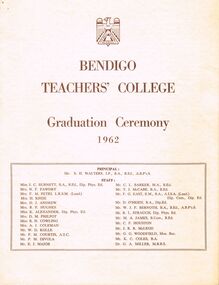 Bendigo Historical Society Inc.
Document - LA TROBE UNIVERSITY BENDIGO COLLECTION: BENDIGO TEACHERS' COLLEGE GRADUATION CEREMONY 1962
Two copies of the Bendigo Teachers' College Graduation Ceremony 1962 program. On the front page is a list of the staff working at the college - Mr. S. H. Walters (Principal), Miss J. C. Burnett, Mrs. N. F. Fawdry, Mrs. F. M. Petri, Mrs. H. Knox, Mrs. D. J. Andrew, Mrs. B. F. Hughes, Miss K. Alexander, Mrs. D. M. Philpot, Miss B. H. Cowling, Mrs. A. J. Coleman, Mr. W. D. Kolle, Mr. F. M. Courtis, Mr. P. M. Divola, Mr. E. J. Major, Mr. C. L. Barker, Mr. T. J. McCabe, Mr. F. G. East, Mr. D. O'Brien, Mr. W. J. F. Bernoth, Mr. R. L. Strauch, Mr. M. A. James, Mr. C. F. Houston, M. J. R. R. McLeod, Mr. G. G. Woodfield, Mr. K. C. Coles and Dr. G. A. Miller. On the inside cover is the "Significance of the Ceremony" and the "Order of the Ceremony". Mr. F. M. Courtis welcomed the visitors and the Principal read the College Charge. The 'Graduation Book' was presented to Mr. W. F. R. Budge by Miss J. C. Burnett. Mr. C. L. Barker presented the T.P.T.C. graduating students to the Principal and Mrs. N. F. Fawdry presented the T.I.T.C. graduating students to the Principal. Congratulations were offered by the Mayor of Bendigo Cr. R. A. Rae, J.P., the President of Strathfieldsaye Shire Cr. K. Houlahan, J. P. and Mr. E. P. Seymour, Head Teacher, Violet Street State School. The Occasional Address was given by Mr. L. J. Pryor Superintendent of Teacher Education. The following page contains a list of the "Students of 1960 - 1962 Trained Infant Teacher's Certificate". They are Glenys Faye Barrett, Marlene Isabella Bemrose, Beth Adora Bodinnar, Margaret Isobel Brown, Doris Lillian Chambers, Marie Ann Crawford, Margaret Carol Donne, Kaye Beverley Exell, Jannette Joyce Hughes, Margaret Christina Jenkins, Kathryn Margaret Lackmann, Susan Anne Lewer, Barbara June Lord, Jennifer Beris Matheson, Joy Lynette Messer, Geraldine Mary, Moylan, Patricia Joan O'Bree, Helen Jeanette Rodda, Lesley Scott, Heather Dawn Shenfield, Nola May Steele, Jennifer Margaret Weston and Alicia Yvonne Young. It also contains a paragraph describing "The Perfect Teacher". The back cover of the booklet has a list of "Students of 1961 - 1962 Trained Primary Teacher's Certificate". John Walter Angel, Elisabeth Ann Arkinstall, Mary Christina Backway, Helen Elizabeth Barclay, Bruce Maxwell Bouch, Pamela Mary Braden, Howard Francis Briggs, Clare Antoinette Brown, Alan John Bruce, Peter John Burns, Valerie Jean Caldwell, Marie Lynette Chambers, Margaret Jeannette Christie, Alison Ruth Clement, Marie Elaine Collins, Gladys Helena Cooke, Lindsay Charles Coster, David John Cowan, Peter John Cronin, Berenice Margaret Cronk, Edeline May Crouch, Theodore Robert Dare, Lynette Joan Davis, Ian David Dawson, Mary DeAraugo, Kenneth Ross Erbs, Francis Elaine Mary Fallon, Margaret Fawcett, Janet Frances Filbey, Francesco Gargiulo, Ian John Glenister, Barbara Faye Gotch, Lynette Ellen Graham, Colin Athol Hayes, Marlene Grace Hazen, Desmond Brian Hearn, Brentford Graeme Heath, Carmel Jean Heslop, Pamela Joy Higgie, Lynette Rosemary Cecelia Hoare, Erica Fay Holloway, Marie Jean Jardine, Kenneth Neil Johnson, Laurel Robyn Jones, Glenys Lorraine Judd, Diane Elizabeth Kear, Ann Elizabeth Keenan, Monica Cecelia Kelly, Margaret Elizabeth Landini, Patricia Joy Langdon, Dorothy Margaret Leitch, Donald Alan Leslie, Mary Carmel McCormack, Helen Mary McCutcheon, Birgitt Marx, Claire Agnes Mullins, Lucille Anne Newcombe, Glenice Vivienne Orr, Judith Joyce Ozanne, Wilma Beverley Pape, Virginia Elizabeth Parke, Robin Parker, Dorothy Joan Peterson, Robin Joan Phillips, Cherril Margaret Probyn, Norma Lesley Rantall, Nola Read, Margaret Elaine Ridley, Thomas Charles Rilen, Marie Therese Sharkey, Judith Margaret Spackman, Desmond Thomas Stephens, Nancy Rae Telfer, Bernard James Trevaskis, Marjorie Ellen Warden, Laurice Helen Warwick, Judith Maree Weir, Maxwell John White, Norman Leslie Williams, Pamela Williams and Lloyd Reginald Wishart. Within this document is a loose page showing the seating arrangements for the graduation. Staff seating arrangements are as follows - Walters, Barker, Seymour, Fawdry, McCabe, Woodfield, Alexander, Hughes, Divola, Major, Strauch, Pryor, Budge, Burnett, East, Houston, Petri, Andrew, Coles, McLeod, James, O'Brien.bendigo, education, bendigo teachers' college graduatio, la trobe university bendigo collection, collection, bendigo teachers' college, bendigo, education, teaching, teachers, students, staff, bendigo teachers' college students, bendigo teachers' college staff, history, graduation, graduation ceremony, book, tertiary education, graduands, graduates -
 Bendigo Historical Society Inc.
Document - Arthur T. Pattinson, 1962
10570 South African (Boer) War Memorial Bendigo. The monument commemorates those who died in service or were killed in action while serving in the South African (Boer) War. It is a bronze statue of a soldier on a granite base. Leader (Melbourne), 19 November 1904. “There was a large assemblage on the afternoon of 11th November, when the ceremony of unveiling the soldiers' memorial statue was performed by Brigadier-General Gordon in the presence of a muster of branches of the defence forces. The statue, which is in bronze, is mounted on a massive granite base, on the foot of which is the following inscription: — "Bendigo's tribute to the memory of the Australian soldiers who, in the South African war of 1899 - 1902 gave their lives for Queen and Empire. The statue was modelled by Mr. J. Walker, a young Bendigonian, who has been studying for two or three years under Mr. A. T. Woodward art instructor at the local school of mines.“ Ola Cohn recalled in her autobiography meeting John Walker as a sculpture student at the Bendigo School of Mines and that he had later received the commission for the Boer War Memorial although she neglects to mention its location. John Walker was born in Bendigo and first studied sculpture at the Bendigo School of Art. Walker, then went to England to study at the Royal College of Art London, and in Paris at the Académie Colarossi and Julian Academy. John Walker worked as a sculptor in both Bendigo and West Brunswick before turning to chicken farming in the Bendigo suburb of White Hills. The photo of A. T. Pattinson was taken by George Leake Massingham, a professional photographer, who had seven children, one of whom died at birth. After arriving in Australia from England, he established himself as a travelling photographer, an occupation he continued after his marriage. He travelled throughout country Queensland, Victoria and New South Wales, setting up studios along the way. The family ended up moving with him, travelling to Sydney, Narrandera, Bendigo, Newtown, Geelong and Deniliquin. Correspondence re Boer War Memorial Bendigo Boer War Memorial Bendigo. Letters and photo from and to Mrs Wilson, eldest daughter of Mr Arthur T. Pattinson who was a model for the Boer War sculpture. 10570a A black and white photo of Trooper Arthur T. Pattinson restored by BHS Volunteers. 10570b The original photo as sent by Mrs Wilson to Harold Curnow (Bendigo Historical Society) in 1962. The photo is mounted on heavy brown cardboard and has an old catalogue number of "P680" inscribed on it. The cardboard is torn and held together with sticky tape. On the front in italics is printed G.L. Massingham, Bendigo. 10570c Notes on the rear of the photo from Mrs Wilson state that "the photo is of Arthur T. Pattinson (Rusty), an Australian Light Horse trooper who served in the Boer War. The Boer War Memorial in Pall Mall Bendigo represents a trooper on guard. The sculptor was Jack Walker who used Pattinson as a model, and it is regarded as an excellent likeness." 10570d A letter from Harold Curnow back to Mrs Wilson on Jan 4th, 1963, acknowledging receipt of the photo and a letter received, noting the significance of the historical information. 10570e Handwritten letter 29/11/1962 from Mrs Wilson to Mr Curnow introducing herself as Mr. Pattinson's eldest daughter and answering the letter he wrote to her father. She mentions the bad health of her parents. Arthur modelled for the statue at least two to three times per week in a studio on the top floor of a building in Bull St. He was the original model to the best of her knowledge. Another model possibly Mr P. Handmear may have sat as a model for renovations (*). The rifle was a light horse rifle issued to Pattinson as he was still serving in 1904. Arthur and Handmear were boys together and very close. * Note - the plaster model was repaired prior to casting in metal. 10570f An obituary notice: 18/11/64 "On Nov. 17 at Frankston, Emma, wife of the late A. T. Pattinson (Rusty), late of Bendigo. 10570g Letter Nov. 20th, 1962, from Harold Curnow to Mr Arthur T. Pattinson, Kent St., Mornington, Vic. "Dear Mr Pattinson, Last week your brother, Brit., whom I have known for many years, supplied the Bendigo Advertiser with some interesting information regarding your role as the model for the late Jack Walker when he was making the statue for the Boer War Memorial here. Yesterday however, another claimant to the distinction of being the model was advanced in the Bendigo Advertiser by Mr Richard Marshall, of Moran Street, Bendigo who said that the soldier's model was Phillip Handmear. I understand that your brother has sent the newspaper cuttings on to you. When he called to see me yesterday, he suggested that I write to you for further particulars. Can you recall the discussion you had with Jack Walker when he approached you about acting as the model and do you remember how many times you posed for him, and whether the work was done in the house, in the yard, or in one of the outbuildings at Moran Street? In short, any details at all. At this point in time we are considering an interesting facet in Bendigo's history, so any seemingly unimportant incidents could really be useful if we knew about them. Have you any old newspaper cuttings mentioning your name in connection with the memorial? Do you remember any remarks that passed between you and Jack Walker during the long sessions you must have put in on this work? This could be very important. And do you recall where the rifle came from? Did you or Jack Walker borrow it from the military authorities? Back in 1934 Jack Walker recalled having had to pull the plaster model down and remake it when he discovered it was slightly off-balance and was slowly toppling forward. He told me he had to get his model to pose again. Do you know anything about this? Could it have been that he got Mr. Handmear in for the final stage of the work? That, of course, would apply only if you were not available. Incidentally, I never heard of Mr Handmear until I saw his name in yesterday's "Advertiser". In any case I intended contacting your brother or you to enquire whether any member of your family has an old photograph of you in your Boer War uniform, that is, one taken about the time of or just after the Boer War. I am sure that members of the Bendigo Branch of the Royal Historical Society would be most interested to see it. I hope you will have the time and inclination to consider the many points I have raised in this letter because the subject has aroused a lot of interest in Bendigo. Hoping you are well and quite as active as you wish, I remain, with all good wishes, Yours sincerely, Harold Curnow". john walker, jack walker, boer war memorial bendigo, arthur pattinson, soldiers' memorial bendigo -
 Eltham District Historical Society Inc
Photograph, Tess Justine (Nillumbik Shire Council), Murray's Bridge over the Diamond Creek, Eltham North, 19 Feb 2022
Murray's Bridge over the Diamond Creek on the Diamond Creek Trail just prior to demolition and replacement with a new steel bridge. Heritage advice obtained by Nillumbik Shire Council, following a suggestion by the Eltham District Historical Society (EDHS), is that the original bridge appears to have been a simplified version of the Country Roads Board’s (CRB) standard timber bridge design of the early-to-mid 1920s. In c1990 Murray’s bridge was renovated with three recycled steel girders as part of a bike/pedestrian path in the reserve. During these alterations many parts of the bridge were removed, and some were replaced. Heritage advice indicates the condition of Murray’s bridge is poor. The remaining original parts are all in poor condition, with severe weathering, splitting and rot, especially to the stringers retained on the bridge. Heritage advice is that Murray’s Bridge does not have sufficient significance in the cultural history of the Nillumbik area to warrant inclusion in the Nillumbik Shire Heritage Overlay and also does not have sufficient significance as a rare survivor to warrant inclusion in the Nillumbik Shire Heritage Overlay. There are no indications in the historical record that this site was individually important to the cultural history of this area. EDHS is comfortable with the heritage advice provided to Council and has worked closely on this project with Council. EDHS has suggested some of the removed timbers be used in the vicinity of the bridge for landscaping and possibly seating, so as to retain these remnants close to the site of the original bridge, which is the last old timber bridge along the lower reaches of the Diamond Creek. Mary (Sweeney) Murray and John Wright Murray selected 80 acres, Lot C Section 16 and Lot 5 Section 17 Parish of Nillumbik, under an occupation license in 1866. John died in 1867 and freehold was granted to his son John in 1873. The farm was known as ‘Laurel Hill’. John Junior was an Eltham Shire councillor and sometime president from 1887 up until 1897. He added Lot A Section 16 to the farm in ca1888. John and his younger brother James arranged to rent/purchase Lot B Section 17, across Diamond Creek to the west, in ca1900. It appears that John and James farmed separately for a few years, with a new homestead built for James ad family on the high point of Lot B Section 17 in ca1910. John sold off Lot 5 Section 17 in 1912. When John died in 1912 James took over the land on both sides of the Diamond Creek. The old homestead on the west side of the Creek disappeared. A farm bridge over Diamond Creek from this period may have been located close to the northern boundary of the farm. John Langlands, owner of the farm known as ‘Ihurst’ on the west side of Diamond Creek to the south of the Murray’s land, died in 1907. In 1909 his land was then subdivided into 100 lots to become the ‘Glen Park Estate’. Other similar subdivisions of nineteenth century farms around Eltham in this period included the ‘Franktonia (or Beard’s) Estate’ to the northeast and ‘Bonsack’s Estate’ between Eltham and Greensborough. Soon after the opening of the railway extension line from Eltham to Hurstbridge in 1912, Glen Park and nearby residents including James Murray agitated for a railway station or siding to be located half-way between Eltham and Hurstbridge, so that the Glen Park residents who used the railway daily did not have to walk into the Eltham or Hurstbridge stations. Some believed Coleman’s Corner (opposite Edendale Farm) was an appropriate spot for the platform. James Murray was among those who thought the railway should be located on his land, closer to half-way between Eltham and Hurstbridge stations. The Railways Commissioners warned that the locals would have to fund these works themselves. The Glen Park Estate residents initially had difficulty accessing Eltham by road, with only an old low-level bridge over Diamond Creek at the south end of their estate. A new timber trestle bridge across the creek, now on Wattletree Road, was opened in 1915. Road access to the north was gained in 1927 when the new Murray’s Road, which crossed the Murray’s land, was built. Residents continued to agitate for a Glen Park station. By 1926 the Railways Commissioners’ preferred site was on the Murray’s land. They arranged an estimate of cost of a full-length platform. The estimate was too much for the locals, who in 1928 argued unsuccessfully for a shorter and hence cheaper platform. By 1929 Murray had agreed to donate the land, but the locals would still have to fund the works. Murray decided, unilaterally it would appear, to commence work on a timber trestle road bridge over Diamond Creek to link the new Murray Road to the proposed station. Late in 1929 he stopped work on the bridge, for reasons unknown, but started work again and completed the bridge in 1931. There is no further newspaper evidence of the campaign for the Glen Park station until 1939, when Murray and another local, Mr Maxwell, met the Railways Commissioner. The Glen Park locale now included 45 homes on the west side of the creek and 20 on the Eltham side. Most of the residents used the train every day. The Commissioner remained adamant that only a full-length platform could be built for safety reasons. It appears the campaign dissolved at this point. The increasing move to cars may have had an impact. There is no evidence of Murray’s bridge ever being connected to Murray’s Road, or of it having wide use for any purpose by locals. James Murray died in 1947 and the farm was taken over by his son James (Jim). Jim started to sell off parts of the farm in the 1980s, retaining a few acres around the ca1910 homestead and building a new house there. Recreation reserves were established along the creek. In ca1990 Murray’s bridge was renovated with steel girders as part of a bike/pedestrian path in the reserve. The old farmhouse was demolished in ca2014. * * * A theory posted on local community Facebook groups was that the bridge was built in the 1860s and was built to be more robust than was necessary for the movement of cows from one side of the creek to the other. It was suggested the robustness was necessary to support the weight of gold ore being transferred from a mine on Murray’s land to a railway siding near Murrays Bridge (presumably for transfer and processing at Diamond Creek). Perhaps this may have been one of the motivators for Murray, who really knows? Knowing when mining operations ceased on his land and how that fits the overall timeline would be useful but at the time the bridge was built, local gold production was minimal at best. The known facts are: • The railway line came to Eltham in 1902. • The extension of the railway from Eltham to Hurstbridge was constructed in 1912 so no railway line even existed through Murray's property until 1912 and the Victorian Railways maps at the time show no such siding on Murray’s property. • In 1923 a new company was formed in anticipation of the old Diamond Creek Gold Mine being re-opened. The mine had been previously closed and flooded. It was noted in the press at the time that the mine was within a mile of the railway. Nothing really came of this. • Construction of Murrays Bridge was commenced by James Murray in early 1929 in anticipation of a proposed flag station being nominated on his land, but work ceased shortly afterwards. The proposed flag station was commonly referred to as Glen Park as the residents of the Glen Park Estate wanted Option 1, located near them with the platform adjacent to Colemans corner. This was probably never going to fly as it was virtually in eyesight of Eltham station. Allandale Road was the third option, but the Commissioners' preferred option was No. 2 - on Murray's property. • The Railway Commissioners were not going to finance any such station and the works had to be funded by private landowners and residents, hence Murray investing in this himself. • Murray recommenced work two years later and finished his bridge in 1931 but unfortunately for him, the proposed flag station never eventuated. The bluestone siding you reference may well have been built by Murray as part of the proposed station platform. • Up until then, apart from the Main Road bridge, which was washed away in 1924, virtually all local crossings over the Diamond Creek were low lying bridges – Kaylocks Bridge at Brougham Street, Diamond Street bridge, Glen Park Road bridge. It is expected that Murray also had a low-lying bridge to connect his land either side of the creek. These were all washed away or severely damaged multiple times in the 1920s. Lessons were learnt, and Murrays Bridge appears to have been built in accordance with Country Road Board standards of the time. Flood damage was ongoing, and even more recently constructed raised bridges kept getting washed away, e.g., the new Wattle Tree Road bridge in 1958 just months after completion. Murray’s bridge was reinforced with steel some 30 years ago presumably to provide additional floodwater resistance, given the history of bridges disappearing in floodwaters. • In March 1932 it was reported in the Advertiser that there were still some prospectors operating around Eltham North who apart from further scarring the face of the earth over the previous two years had gained significant experience but little gold - hardly a driving factor for constructing a dedicated railway siding and bridge to transfer gold ore. It is far more probable that James Murray was hoping to have the railway station located on his property and invested his money by building the bridge to lead to it as well as a station platform. Had the station eventuated, it may well have driven up the value of his land for subdivision and new housing estates like the Glen Park Estate. That did not eventuate. Whilst the bridge was indeed old (90 years), the core structure being completed in 1931, it had been modified substantially from original and hence had no significant historic value – i.e., it was not a representative example of its type, construction, and age. Given that the bridge was not worthy of saving, the Eltham District Historical Society with Council’s support, and the Eltham Woodworkers group endeavoured to see what suitable sized timbers were salvageable to fabricate a commemorative seat. Unfortunately, the experts at the Woodworkers group were unable to salvage any suitable length/width timbers to fabricate the seat due to the presence of rot. Last remaining wooden trestle bridge on the Diamond Creek Trail just prior to demolition and replacementBorn digital image (27)diamond creek (creek), diamond creek trail, murrays bridge, ‘laurel hill’, john wright murray, mary (sweeney) murra, john murray jnr, james murray, john langlands, ‘ihurst’, ‘glen park estate’, beard's estate, franktonia, bonsack's estate, glen park estate, glen park railway station -
 Lara RSL Sub Branch
Flag, Australian Flag (Union Jack) 1900
There is a Union Jack brought back from South Africa by 1229 Trooper Fredrick James Smith. Between 1899 and 1902, around 16,500 Australians served in South Africa during the Boer War. This was the largest international deployment of troops from the Australian Colonies before Australian Federation. Of the 16,500 men who served in South Africa, 606 were killed in action or died of diseases. The Australian War Memorial records that the fighting conditions in South Africa extremely hard on men and horses. Australians fighting in South Africa were doing so as part of Colony based Regiments such as the Victorian Mounted Rifles, New South Wales Lancers, Queensland Mounted Infantry as well as units from the other states. Australians were awarded six Victoria Crosses during the campaign along with many other decorations. In May of 1902 the treaty of Vereeniging was signed officially ending the Boer War. The Boer War is commemorated in many Towns and Cities around Australia. The Lara RSL Sub Branch holds some memorabilia from the Boer War. There is a Union Jack brought back from South Africa by 1229 Trooper Fredrick James Smith. He was a resident of Lara and was a member of the 5th Victorian Mounted Rifles. It was reported that he carried this flag into battle. The Lara RSL also holds the flag staff of the China, South African and Old Veterans Association. Both these items are of national significance. Both the flag and flag staff were used in marches in Geelong each year until 1916 when Anzac Day commenced. The flag and flag staff were donated to the Lara RSL sub Branch when he joined in 1928. Fredrick James Smith was born at Lara in 1879, the son of Mr/Mrs Smith from Lara. He was a farm hand from Horton Vale, Anakie when he joined F Company of the 5th Victorian Mounted Rifles at the beginning of February 1901. Two weeks later, he left for South Africa on the 15th February. Before leaving, he purchased the flag from W. Libby & Son Geelong. Frederick Left for South Africa on the 15 February 1901 on the Orient. He saw service between March 1901 - March 1902 in east Transvaal and Natal frontier under the British Major General S. Beatson then Pulteney, including the defeat at Wilmansrust where 18 soldiers were killed and 42 wounded (12th June 1901 - heaviest casualties of any Australian contingent,); and the successful intervention at Onverwacht on the 4th January 1902. The 5th Victorian Mounted Rifles suffered: 36 killed or died of wounds, 13 died of disease of a contingent of 46 Officers, 971 Other Ranks and 1099 horses. They returned to Australia on the 26th April 1902 on the Custodian after sailing from Point Natal in South Africa on the 5th April. On his return, Tropper Smith (Saddler Private) joined the South African Soldiers Association of Victoria – Geelong Branch, and after 1928, he joined the Lara RSL. He was buried in Western Cemetery on the 19th June 1968 at the age of 89. Enrolled February 1901 Departed for South Africa on 15 February 1901 Establishment: 46 Officers, 971 Other Ranks with 1099 horses Mobilised at Pretoria: 24 March -- 4 April 1901 Typical company: 1 Captain, 4 Lieutenants, 1 company sergeant-major, 1 company quartermaster-sergeant, 1 sergeant-farrier, 1 sergeant-saddler, 5 sergeants, 6 corporals, 3 shoeing-smiths, 3 saddlers, 1 bugler, 99 privates. Total in company: 126 with 131 horses. Engagements: Rhenoster Kop, Klippan, Kornfontein, Drivelfontein, Wilmansrust, Kambuladraai, H'Lobane, Luchiel's Nek, Loch's Kraal, Vryheid, Onverwacht, Johnston Hoek Killed in action (or died): six Officers, 48 Other Ranks VC Winner: Lieut. L. C. Maygar News article Leader (Melbourne) Saturday 31st May 1902, page 42 - Dear Cinderella. — This is the second time I have written to you. I was very sorry at not seeing my first letter in "The Leader". But I hope to say, that this one will be in. The last time I wrote to you I told you that my brother (Fredrick Smith) went to the Boer War in South Africa, and that he was supposed to be killed in the Wilmansrust disaster. But this time I am going to tell you about his return, and the grand welcome he got from the residents of Lara. Mother, Father, and my Brother, went down to Melbourne, to meet the boat. You can just imagine how rejoiced we all were to see him back again. The railway station was decorated some thing beautiful with flags of all description all the colours you could think of. He has bought a lot of Boer curios home and some Kaffir bracelets. They are such funny looking things. The residents of Lara, also gave my brother a grand social and ball there were over four hundred people present, They presented him with a hand some gold chain, and locket suitably inscribed, and a pair of gold sleeve links, they were magnificent. The ball was very nice. . I had a few dances. I enjoyed myself grand. I think this is all I can tell you this time. I must conclude with love. I remain yours sincerely - BESSIE SMITH. Age 14-years. This flag is of national significance as it was used in the Boer War by Private Fredrick James Smith (SN:1229) of the 5th Victorian Mounted Rifles, F Company in their deployment to South Africa between 1901 and 1902. The flag was taken into the Wilmansrust engagement in which 19 soldiers died and 41 were wounded. On return to Australia, the flag was used in marches by the South Africa, China Old Veterans Association - Geelong. This flag represents a unique part of Australian history from which the movie, Breaker Morant was taken. It is of spiritual significance as the Boer War was where the first Australian received the Imperial Victoria Cross, and the spirit of Anzac was conceived, giving birth in World War 1. The Flag represents the spirit of Australians who fought and died in South Africa.Cotton Union Jack flag approx 221cm wide by 109cm tall with small repair patches and center section cotton deteriorated.Has the word "Lara" inscribed in black on bottom part of the flag heading. Has the flag makers name "W.Libby & Son" on the top part of the flag heading.boer war, union jack flag, south africa, wilmansrust, 5th victorian mounted rifles, f coy, private fredrick james smith, service number 1229, february 1901, april 1902, south africa china old veterans association -
 Coal Creek Community Park & Museum
Bottle, glass, c. 1885
150 years of experience and commitment. Norwegians have been producing and exporting cod liver oil for more than 1000 years. But it was not before 1645 it was reported that cod liver oil could be used to prevent and cure disease. At the end of the 18th century the first scientific article was published to support this. In the middle of the 19th century, the pharmacist Peter Möller observed that people along the west coast of Norway consuming cod liver oil regularly were rarely ill. He dedicated himself to finding out how this healthy liquid could be produced with better taste and pureness at a lower price. He developed a method of using steam to extract the oil from fresh cod livers. Based on this technological advance, the company Peter Möller was founded in 1854 in Lofoten on Norway’s arctic coast, where you find pure, cold, clean seas and high quality raw material. Peter Joachim Möller (1793-1869) At first Möller’s Cod Liver Oil was believed to be a good source of vitamin D and A, and the health benefits were associated with these vitamins. Peter Möller believed, however, that there were other significant benefits from fatty acids and other ingredients in the cod liver oil – both known and unknown. Peter Möller was dedicated to understanding more about these benefits. His dedication and commitment is clear in Möller's vision to improve people’s health by delivering the highest quality omega 3 products. Timeline 1793 Peter Möller is born in Røros, Norway 26 April. 1819 Peter Möller travels to Christiania (Oslo) and is employed by the pharmacist Frantz Peckel at the Svane chemist. He is employed on condition that he passes his pharmaceutical exam within one year. 1822 Graduated as a pharmacist with a unanimous first grade and with the award of the Professor's special satisfaction. 1842 Together with professors A. Holst and Chr. Boeck, Peter Möller participates in the commission which develops the first Norwegian Pharmacopoeia. 1853 Peter announces his method to cod liver oil works along the coast. He equips cod liver oil factories with new equipment in Lofoten, Ålesund and Kristiansund. The facility outside Ålesund is the most important for testing the method. 1854 The Peter Möller company is established as production has started at the three factories. Sales are lower than anticipated even though the quality is considerably better with the new method. The consumers of cod liver oil had been used to the fact that “good medicine must taste bad” and would not believe that the new and better quality was as healthy. Therefore, the following years are used to introduce consumers to the product, and also to convert more producers to the new method. 1869 Peter Möller dies. There are 70 cod liver oil steamers which use his steam rendering method, and 5000 barrels are produced every year. Möller’s company increases the quality by better routines for quality controls. 1870 Severin A Heyerdal, Möller’s son-in-law, assumes the leadership of the firm after Peter's death. He continues the work by improving the quality of the cod liver oil. The goal was to make it as pure and unaltered as in the liver. At this time, Möller had already started selling its product in the USA. In 1870, WH Schieffelin & Co. ("The oldest drughouse in America") was engaged by Peter Möller in the USA. 1881 Frantz Peckel Möller assumes the leadership of the Peter Möller company. He saw it as his duty to further the work on cod liver oil, and through a combination of solid scientific education and an eminent sense of the great mercantile possibilities, he made Möller’s cod liver oil the number one in the world market. 1914 The first world war leads to Möller’s bottled cod liver oil being shut out of the export market. However, domestic sales are good. 1924 The subsidiary Møystad Möller & Co. is established for bulk exports and the Association of Medicinal Cod liver oil Exporters is established in Bergen in 1925. 1925/26 The green bottles are introduced. Medicinal cod liver oil exports remain almost constant, while total Norwegian cod liver oil exports increase. 1938 The factory on the Løren grounds in Oslo, Norway is built. The factory is in the same place today. Peter Möller’s Pharmaceutical Laboratorium A/S is also established to separate out the scientific business. Investment is made in a new facility for refining and bottling veterinary cod liver oil, and increased production of industrial cod liver oil. 1940 The outbreak of the 2nd world war sees exports fall dramatically, while cod liver oil’s significance as a dietary supplement receives increased attention. Domestic sales increase strongly. 1945 After the war, medicinal cod liver oil retains its high status as an important dietary supplement in the “rebuilding" of the country. Cod liver oil becomes an ”emergency product in ravaged areas where the supply situation is difficult. Competition from other countries such as the USA, England and Iceland increases, and Norway no longer dominates the market. 1983 Möller’s cod liver oil in capsule form is launched and palatable cod liver oil is launched. 1990 Peter Möller A/S merges with Orkla Borregaard A/S (now ORKLA) 2005 Peter Möller merges with CollettPharma. The new company is called MöllerCollett. 2007 Merger between MöllerCollet and DanskDroge. The new company is called Axellus. Oval in section with a thin neck, mauve tinted clear glass bottle with text embossed on side.On side : 'P.MOLLER', 'OL JECOR', 'GADOR VER', 'CHRISTIANIA'.cod liver oil, norway, peter moller, christiana, oslo -
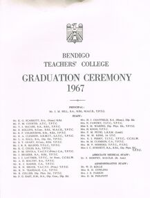 Bendigo Historical Society Inc.
Document - LA TROBE UNIVERSITY BENDIGO COLLECTION: BENDIGO TEACHERS' COLLEGE GRADUATION CEREMONY 1967
A white document titled "Bendigo Teachers' College Graduation Ceremony 1967" and below this is a list of the college staff. They are Mr. J. M. Hill (Principal), Mr. K. G. Scarrott, Mr. F. M. Courtis, Mr. T. J. McCabe, Mr. B. Rollins, Mr. R. F. Colbourne, Mr. B. A. Clemson, Mr. L. A. Hall, Mr. B. T. Geary, Mr. J. J. R. McLeod, Mr. K. C. Coles, Mr. P. M. Divola, Mr. J. Brasier, Mr. J. J. Layther, Mr. A. D. Maltby, Mr. R. J. Harris, Mr. R. N. Bruce, Mr. R. N. Teasdale, Mr. R. Collis, Mr. F. G. East, Mrs. H. J. Chatfield, Mrs. N. Fawdry, Miss S. M. Waring, Mrs. H. Knox, Mrs. F. M. Petri, Mrs. M. M. Kerr, Mrs. E. I. Perry, Mrs. M. M. Clemson, Mrs. M. P. Hibberd, Miss J. C. Burnett, and Dr. S. Morphy (Medical Staff). Administrative Staff - Mr. W. D. Kolle, Miss B. H. Cowling, Mrs. J. E. Parkin and Mrs. D. M. Philpott. On the inside cover is the "Significance of the Ceremony" and "Order of the Ceremony". A Welcome to Visitors was given by Mr. B. A. Clemson and the College Charge was read by the Principal. The Graduation Book was presented to Mr. W. F. R. Budge by Mrs. H. Chatfield the Dean of Women Students. Mr. K. G. Scarrott presented the T. P. T. C. students to Dr. W. C. Radford and Mrs. N. F. Fawdry presented the T. I. T. C. students to Dr. W. C. Radford. Congratulations were offered by The Mayor of Bendigo Cr. W. Cambridge, the President of Strathfieldsaye Shire Cr. M. O'Halloran and Mr. E. J. Allison, Head Master of Golden Square State School. Dr. W. C. Radford gave the Occasional Address.The following page contains the names of the students of 1965 - 1967 who received their Trained Infant Teacher's Certificate. - Margaret Mary Therese Atchison, Sandra Margaret Therese Atkinson, Jennifer Margaret Barker, Marilyn Joan Durbridge, Sandra Faye Ermel, Jeanette Craig Ferguson, Janice Mary Fee, Annette Gargiulo, Jennifer Mary Hawkins, Jocelyn Ann Heslop, Julie Marion Hopper, Susan Mary Howard, Donnette Ann Hufer, Dorothy Joan King, Leonie Anne Mackay, Mary Bernadette McCurry, Diane Margaret Louise McPherson, Jennifer Evelyn Mansfield, Maureen Moait, Jennier Joy Mouser, Marie Jeannette O'Brien, Ann Lorraine Pawley, Pamela Jeanette Phillips, Wendy Roma Rainey, Lynette Jean Robinson, Nola Mary Sawers, Margaret Ellen Sheridan, Rosalie Heather Smith, Marianne Catherine Stockx, Margery Lois Storey, Joyce Eidirien Waidabu, Barbara Joan Webb, Marion Joyce Wright and Margaret Joan Young. This page also contains the names of the students who graduated with their Trained Primary Teacher's Certificate 1966 - 1967. - Merylyn Dale Abbot, Janet Ann Angus, Robert Maxwell Anset, Jocelyn Gray Astbury, Catherine Mary Backstrop, Anne Margaret Becker, Graeme Kenneth Blake, Mary Margaret Bourke, Ruth Yvonne Bradbury, Mary Elizabeth Carstensen, William Stephen Carthew, Glenda Marjory Childs, Rae Mary Chittock, Elizabeth Lorraine Colville, Robyn Elizabeth Connelly, Michael Thomas Corboy, Richard George Cowan, Carmel Margaret Delaney, Margaret Ruth Dettman, Bryan John Dillon, Suzann Margaret Fahey, John Stuart Fleming, Maxwell George Fletcher, Valma Mary Foreman, Joan Elsie Gillespie, Beverley Joan Ham, Leonard Jack Heathcote, John Edward Higgs, Pauline Susan Hobby, Rhonda Carolyn Hunter, Heather May Kennedy, Gillian Anne Knight, Anne Elizabeth Layton, Judith Irene Learmonth, Jean Annette Leversha, Judith Katherine Longhurst, Jeannie Elizabeth Anne McKerrow, Charles Bryan Mathieson, Judith Lorraine Mills, Patsie Murphy, John William Norman, Jocelyn Anne Nunn, Helen Margaret O'Donoghue, Andrea Palmer, Carolyn Joy Palmer, Arthur Henry Parker, Sandra Jean Peace, Anne Marie Pianta, Margaret Joan Plant, Lawrence John Plowman, Graeme Kenneth Proud, Nancy Elizabeth Raven, Colleen Margaret Reid, Glenda Ann Rogerson, Vivienne Lorraine Roscoe, Peter Thomas Ryan, Bruce Robert Scriven, Margaret Lorraine Seddon, Ann Shemshedin, Heather Joy Shields, Margaret Susan Snow, Lee-ann Robyn Spittal, Graeme George Stanyer, Marie Stevenson, Jennifer May Teague, Kenneth William Thomas, Kerry Joy Tobias, Patrick James Tobin, Jennifer Anne Todd, Helen June Trevaskis, Faye Lynette Turner, Rosemary Gaye Ward, Peter Edward White, Barbara Lindsay Wotherspoon, Fairlie Grace Young, and Katherine Rosalee Zerbst The back cover has the "Principal's Charge to the Graduands" and "The College Anthem". The Conductress being Mrs. F.M. Petrie and the Pianist Miss M. Shaw.bendigo, education, bendigo teachers' college graduatio, la trobe university bendigo collection, collection, bendigo teachers' college, bendigo, education, teaching, teachers, students, tertiary education, graduation, graduation ceremony, graduands, bendigo teachers' college staff, bendigo teachers' college students, graduands, graduates, book -
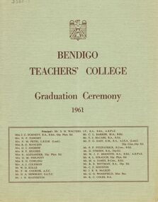 Bendigo Historical Society Inc.
Document - LA TROBE UNIVERSITY BENDIGO COLLECTION: BENDIGO TEACHERS' COLLEGE GRADUATION CEREMONY 1961
A light green document titled "Bendigo Teachers' College Graduation Ceremony 1961". The front page also contains a list of the staff working at the college. They are Mr. S. H. Walters (Principal), Miss J. C. Burnett, Mrs. N. F. Fawdry, Mrs. F. M. Petri, Miss R. E. Manlein, Mrs. D.J. Andrew, Mrs. B. F. Hughes, Miss K. Alexander, Mrs. D. M. Philpott, Miss B. H. Cowling, Mrs. A. J. Coleman, Mr. W. D. Kolle, Mr. F. M. Courtis, Mr. D. A. Newbury, Mr. J. H. Masterton, Mr. C. L. Barker, Mr. T. J. McCabe, Mr. F. G. East, Mr. P. F. Fitzpatrick, Mr. D. O'Brien, Mr. W. J. F. Bernoth, Mr. R. L. Strauch, Mr. M. A. James, Mr. R. E. Wittman, Mr. C. F. Houston, Mr. J. R. R. McLeod, Mr. G. G. Woodfield and Mr. K. C. Coles. The inside cover contains the "Significance of the Ceremony" and "Order of the Ceremony". Mr. F. M. Courtis welcomed the visitors and the Principal read the College Charge. The 'Graduation Book' was presented to Mr. A. L. Harris, Inspector of Schools, by Miss J. C. Burnett. Mr. C. L. Barker presented the 1960-1961 T.P.T.C. graduates to the Principal and Mrs. N. F. Fawdry presented the 1959-1961 T.I.T.C. graduates. Congratulations were offered by the Mayor of Bendigo Cr. F. W. Clayton, J.P. the President of Strathfieldsaye Shire, Cr. G.T. Gleeson and Mr. C. Campbell Head Teacher and Golden Square State School. The Occasional address was presented by Mr. E.C. Kreiger the Assistant Chief Inspector of Primary Schools. The following page contains a list of "Students of 1959-1961 Trained Infant Teacher's Certificate" - Bronwyn Mary Anthony, Helen Rose Argall, Betty Gay Ashby, Edna Rose Attewell, Barbara Christine Bailey, Barbara Isabelle Banfield, Cathleen Mary Banko, Kathleen Margaret Beard, Barbara Anne Beck, Mavis Lynette Brock, Cecily Joan Callister, Kathleen Mary Comer, Alison Jane Currie, Nola Curtis, Margaret Ellen Dowd, Jenifer Lorraine Every, Margaret Jane Ewing, Marie Therese Farrell, Linsey Jean Ferguson, Margaret Esther Fisher, Jean Margaret Fraser, Margaret Ruth Hallett, Elsie Frances Hamilton, Janice Ann Hutchinson, Judith Anne Knopp, Jennifer Mary Ruth Layton, Evelyn Jeanette McKean, Pamela Margaret McMahon, Astrid Norma Magnusson, Jennifer Ann Major, Elaine Joy Maple, Margaret Mary Morrow, Maureen Agnes O'Brien, Geraldine Anne O'Connor, Wendy Nanette O'Neill, Pamela Elsie Parker, Margaret Parslow, Lynette Margaret Pearce, Diane Olive Pell, Gladys Pope, Denise Helen Margaret Potter, Yvonne Joy Puckey, Georgina Mary Rodda, Margaret Agnes Schmidt, Barbara Marion Dorothy Stanton, Rosemary-ann Tipple, Penelope Ann Wallace and Nola Vivienne Williamson. A copy of "Goethe's Nine Essentials for Contented Living" followed this list of students. The back page has a list of the "Students of 1960-1961 Trained Primary Teacher's Certificate" - Ian Roy Aitken, Laurence James Aitken, Daryl Lewis Allemand, Raymond Thomas Arthur, Allan John Attwood, Peter Donald Bavinton, Graham John Bayles, Barry John Cameron, Margaret Suesan Chapman, Elizabeth Rae Clark, Kenneth Clarence Collins, Gavin Ernest Collinson, Terrance Richard Cook, Alan James Daniel, Peter Charles Derrick, Retford John Reuben Dettmann, John William Dicker, Judith Margaret Edwards, Donald Bertram Elshaug, David Forrester, Rodney Robert Foy, Clare Denise Frigerio, Colin David Gaylard, Barry Alexander Gemmell, Anne Isobel Godward, Peter Rodney Goode, John Jefferson Goold, John James Goonan, Ann Merilyn Hamilton, Thelma Grace Hartland, Jennifer Iris Hartvigsen, Bernice Joy Holland, Christopher John Hunt, Marjorie Catherine Iddles, Colin James Jenkins, Darryl Allan Jobling, Marcia Lillette Johnson, Albert Jordon, Janet Laurel Kennedy, John Joseph Kennedy, Malcolm James Kennedy, Frances Marjorie Leach, John Edward Lewis, Ivan James McCarrey, Kerry Francis McCartney, Graeme John McKean, Ian Hamilton McLean, David George Martin, John Russell Meers, Elizabeth Carolyn Miller, Ian Malcolm Morley, Campbell Frederick Muller, Noni Clare Murphy, Patricia Marie Murphy, Anne Mustey, Pauline Elizabeth Norman, Janice Anne North, Joan Margaret O'Callaghan, Margaret Mary O'Connor, William James Ovenden, Gordon Richard Patterson, Lawrence George Pattinson, Marcia Nancy Penrose, Judith Elaine Plant, Peter Alwyn Neville Aloysius Pritchard, Janice Yvonne Reid, David Barry Richards, William Clifford Richards, Geoffrey Roy Rodwell, Glenese Theresa Shanahan, Elizabeth Mary Shaw, Ian Russell Stapleton, Beverley Adeline Stevenson, Ronald John Stone, Nicholas Henry Sulinski, Daryl John Tatt, Brendan Joseph Tinkler, Roy Hamilton Trimble, Kenneth Graham Utber, Beverley June Vickers, Melva Elaine Vinnicombe, John Cornforth Waldron, Bruce Henry Walker, Frederick Robert Weight, Norman James West, Geoffrey Arthur Wigg, Lynette Patricia Wilkinson, Valiant Roy Wojtkiw, Janice Rae Woodcock, Peter Joseph Woods, Aleathea Nola Wootton and Susanne Katherine Yeamanbendigo, education, bendigo teachers' college graduatio, la trobe university bendigo collection, collection, bendigo teachers' college, bendigo, education, teaching, teachers, students, bendigo teachers' college students, bendigo teachers' college staff, tertiary education, history, graduates, graduands, book, teacher training, graduation ceremony -
 Federation University Historical Collection
Photograph - Colour, Jarrod Watt, Hong Kong Street Flyer by an unknown artist, 2019, 06/2019
Carrie Lam, Hong Kong’s chief executive, had plenty of political support in the territory’s pro-Beijing legislature to pass a bill that would allow extraditions to mainland China. The legislators were set to begin discussing the bill in early June, and intended to vote on it just weeks later. A series of protests took place, and after a June 16 protest saw the largest turnout yet, Ms. Lam made a major concession: She postponed the bill, at least temporarily. It was an undeniable victory for the protesters — but it did little to quell the unrest. Since the bill could later be reintroduced, protesters felt they remained in danger. The police tactics to break up the demonstrations on June 12, including the use of more than 150 tear gas canisters to push protesters far away from the government office, created a new set of demands from the protesters. Now, instead of just calling for the withdrawal of the bill and Ms. Lam’s resignation, they said they wouldn’t be content unless there was an independent investigation of officers’ conduct. They also wanted the release of protesters arrested on June 12, and for the government to rescind its description of the demonstrations as a “riot,” a designation that carries legal significance. None of that has happened. Many analysts say Ms. Lam is unlikely to step down, nor would Beijing accept her resignation if she offered it. She has more wiggle room on the other demands, but has not indicated any willingness to budge. The Hong Kong Protests are a leaderless, digital movement.There is no single leader or group deciding on or steering the strategy, tactics and goals of the movement. Instead, protesters have used forums and messaging apps to decide next steps. Anyone can suggest a course of action, and others then vote on whether they support it. The most popular ideas rise to the top, and then people rally to make them happen. At its best, this structure has empowered many people to participate and have their voices heard. Protesters say it keeps them all safe by not allowing the government to target specific leaders. Their success in halting the extradition bill, which was shelved by the territory’s chief executive, speaks to the movement’s power. Despite the lack of a clear leader, protesters have shown extensive coordination at the demonstrations, having planned the specifics online beforehand. Supply stations are set up to distribute water, snacks, gloves, umbrellas and shields made of cardboard. Volunteer first aid workers wear brightly colored vests. People form assembly lines to pass supplies across long distances, with protesters communicating what they need through a series of predetermined hand signals. Anyone walking in dangerous areas without a helmet or a mask is quickly offered one. No individual can speak on behalf of the protesters, which makes negotiations difficult, if not impossible. (https://www.nytimes.com/2019/07/02/world/asia/hong-kong-protest-explained.html, accessed 07/07/2019) Hong Kong’s amended extradition law would allow the extradition of suspects to mainland China for the first time. Supporters say the amendments are key to ensuring the city does not become a criminal refuge, but critics worry Beijing will use the law to extradite political opponents and others to China where their legal protections cannot be guaranteed. The government claims the push to change the law, which would also apply to Taiwan and Macau, stems from the killing last year of a Hong Kong woman while she was in Taiwan with her boyfriend. Authorities in Taiwan suspect the woman’s boyfriend, who remains in Hong Kong, but cannot try him because no extradition agreement is in place. Under the amended law, those accused of offences punishable by seven years or more in prison could be extradited. The new legislation would give Hong Kong’s leader, known as the chief executive, authority to approve extradition requests, after review by the courts. Hong Kong’s legislature, the legislative council, would not have any oversight over the extradition process. Many Hong Kongers fear the proposed extradition law will be used by authorities to target political enemies. They worry the new legislation spells the end of the “one country, two systems” policy, eroding the civil rights enjoyed by Hong Kong residents since the handover of sovereignty from the UK to China in 1997. Many attending the protests on Sunday said they could not trust China as it had often used non-political crimes to target government critics, and said they also feared Hong Kong officials would not be able to reject Beijing’s requests. Legal professionals have also expressed concern over the rights of those sent across the border to be tried. The conviction rate in Chinese courts is as high as 99%. Arbitrary detentions, torture and denial of legal representation of one’s choosing are also common. Many in the protests on Sunday 09 June 2019 said they felt overwhelmed by a sense of helplessness in the face of mainland China’s increasing political, economic and cultural influence in Hong Kong. Hong Kong’s top political leader is not elected by ordinary voters but by a 1,200-strong election committee accountable to Beijing. Half of its legislature are chosen through indirect electoral systems that favour pro-Beijing figures. Many Hong Kongers also cited the jailing of leaders and activists from the 2014 Occupy Central movement– a 79-day mass civil disobedience movement – as well as the disqualification of young localist lawmakers as signs of the erosion of civil freedoms. Resentment towards China has been intensified by soaring property prices – with increasing numbers of mainland Chinese buying properties in the city – as well as the government’s “patriotic education” drive, and the large numbers of mainland tourists who flock to Hong Kong. Many Hong Kongers are also concerned about China’s growing control over the city’s news media, as they increasingly self-censor and follow Beijing’s tacit orders. https://www.theguardian.com/world/2019/jun/10/what-are-the-hong-kong-protests-about-explainerPhotograph of a street art poster taken on the streets of Hong Kong during the protests against legislation to allow Hong Kong suspects to be extradited to mainland Chinese carrie lam, hong kong protests, extraditions, poster art, posters