Showing 4021 items
matching surveying
-
 Bendigo Military Museum
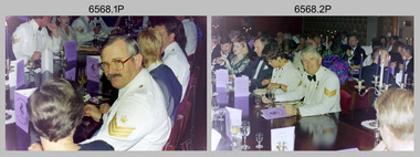
Photograph - 4th Field Survey Squadron Corps Day Formal Dinner, Keswick Barracks, Adelaide SA, 1994
This is a set of photographs of a 4th Field Survey Squadron Officers, Warrant Officers and Sergeants Corps Day Formal Dinner held at Keswick Barracks, Adelaide SA in July 1994. It is apparent there were visiting personnel from the Army Survey Regiment and other unidentified units. This is a set of 26 photographs of a 4th Field Survey Squadron Officer, Warrant Officer and Sergeant’s Formal Dinner held at Keswick Barracks, Adelaide SA in July 1994. The colour photographs are on 35mm negative film and are part of the Army Survey Regiment’s Collection. The photographs were scanned at 96 dpi. .1) - Photo, colour, 1994. Facing camera – SSGT Brian Collings. .2) - Photo, colour, 1994. L to R: facing camera – John Jones, Sharon Jones, Peter ‘Jack’ Elverd, Julie Elverd, SGT Martin Evans, remainder unidentified. .3) - Photo, colour, 1994. Unidentified guests. .4) - Photo, colour, 1994. L to R: facing camera – unidentified (x2), SSGT A. Simcock, SGT Peter Hardy, unidentified, MAJ Bob Williams. .5) - Photo, colour, 1994. L to R: facing camera – unidentified (x2), SSGT Pat ‘Fuji’ Drover, unidentified guests (x2), Ian Belmont, unidentified. .6) - Photo, colour, 1994. L to R: facing camera – unidentified (x4), Allan Adsett, Judyne Adsett, unidentified, LT Andrew Caudle, unidentified. .7) - Photo, colour, 1994. L to R: facing camera – unidentified (x7), Allan Adsett. SPR Chris Pearse (steward), Eddie Jacobs (in background). .8) - Photo, colour, 1994. John Zuringer (flower in lapel) remainder unidentified. .9) - Photo, colour, 1994. L to R: facing camera – unidentified, LTCOL George Ricketts (Ret), remainder unidentified. .10) - Photo, colour, 1994. Head table facing camera L to R: unidentified (x2), OC MAJ Peter Demaine, unidentified, WO2 Peter Hammer, SSGT Lynn Johnson, DSVY-A COL Simon Lemon. .11) - Photo, colour, 1994. Food preparation. L to R: LCPL Mitch Oake, unidentified. .12) - Photo, colour, 1994. Dixie bashing. L to R: CPL Brett Parkin, remainder unidentified. .13) - Photo, colour, 1994. Locker art. .14) - Photo, colour, 1994. Dixie bashing. SPR Mark McInerney. .15) - Photo, colour, 1994. L to R: facing camera – unidentified, Bob Williams, unidentified (x3), SGT Mark Donnelly (in background). .16) - Photo, colour, 1994. L to R: facing away from camera – LTCOL George Ricketts (Ret), unidentified. Facing camera - unidentified (x9), Allan Adsett, Judyne Adsett, unidentified, LT Andrew Caudle, unidentified(x2). .17) - Photo, colour, 1994. L to R: facing away from camera – LTCOL George Ricketts (Ret), unidentified. Facing camera - unidentified (x9), Allan Adsett, Judyne Adsett. .18) - Photo, colour, 1994. Head table facing camera L to R: SSGT Lynn Johnson (edge of photo), DSVY-A COL Simon Lemon, unidentified, CAPT Chris Topovsek, unidentified in foreground, WO1 Stevo Hinic. .19) - Photo, colour, 1994. Head table facing camera L to R: unidentified, OC MAJ Peter Demaine, unidentified, WO2 Peter Hammer, unidentified (x2) in foreground. .20) - Photo, colour, 1994. L to R: facing camera – unidentified (x4), WO1 Mick Sarson, unidentified (x2). .21) - Photo, colour, 1994. L to R: facing camera – unidentified, SSGT Brian Collings, unidentified, WO2 Roger Rees, unidentified (x3), CAPT Tony Stephens. .22) - Photo, colour, 1994. L to R: facing camera – unidentified, SSGT A. Simcock. .23) - Photo, colour, 1994. L to R: facing camera – unidentified, SSGT A. Simcock, SGT Peter Hardy. .24) - Photo, colour, 1994. L to R: facing camera – Lorraine Talbot-Smith (edge of photo), WO2 Ken Talbot-Smith, unidentified, WO2 Simon ‘Andy’ Capp, unidentified, Eddie Jacobs. .25) - Photo, colour, 1994. L to R: facing camera – unidentified, SGT H. Evertz, Pat Belmont, Ian Belmont. .26) - Photo, colour, 1994. L to R: facing camera – unidentified, CAPT Tony Stephens, unidentified..1P to .26P – There are no personnel identified. ‘1994 CORPS BIRTHDAY’ annotated on negatives sleeve.royal australian survey corps, rasvy, 4 fd svy sqn -
 Bendigo Military Museum
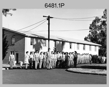
Photograph - Commanding Officer’s Parade at the Army Survey Regiment, Fortuna Villa, Bendigo, c1977
This is a set of 11 photographs of a Commanding Officer’s (CO’s) Parade held at the Army Survey Regiment, Bendigo in circa 1977. Key appointments at the time were LTCOL Bob Skitch, the Commanding Officer from 1976 to 1980 and WO1 Aub Harvey, the RSM of the unit from 1976 to 1982. The dates on the cover sheet are incorrect as female personnel appear in the summer uniform that was superseded in early 1979.This is a set of 11 photographs of a Commanding Officer’s (CO’s) Parade held at the Army Survey Regiment, Bendigo in circa 1977. The photographs were printed on photographic paper and are part of the Army Survey Regiment’s Collection. The black and white photographs were scanned at 300 dpi. .1) - Photo, Black & white, c1977. Air Survey Squadron L to R: WO1 Bob Mason, PTE CPL Marrianne (Van De Zee) De Groot, PTE Julia (Spark) Fitts, CPL Greg Gilbert, unidentified (x2), SGT Bruce Gordon, remainder unidentified. WO1 Graeme Birrell on far right. .2) & .3) - Photo, Black & white, c1977. Air Survey Squadron L to R: SPR Bob Clisby, CPL Alan Staley, unidentified, CPL John Smith, unidentified, CPL Phil McGuire, CPL Peter Mustart, SPR Gary Ames, WO1 Bob Mason – in foreground, unidentified, PTE Julia (Spark) Fitts, unidentified (x2), PTE CPL Marrianne (Van De Zee) De Groot, unidentified (x2), CPL Greg Gilbert, SGT Bruce Gordon. .4) - Photo, Black & white, c1977. Headquarter Squadron L to R: WO2 Max Neil, WO1 Alex Cairney, unidentified, SSGT Pat Lumsden, unidentified (x2), CPL Eddie Jacobs, unidentified (x3), SSGT Alan Strain, CPL Jim Cook. .5) - Photo, Black & white, c1977. Lithographic Squadron L to R: WO1 Tibby Szentirmay BEM, SSGT Jeff Lynch, unidentified, WO1 Fred Panknin, unidentified, SPR Mick ‘Buddha’ Ellis, unidentified, CPL Warren ‘Waldo’ Shirley, CPL John ‘Flash’ Anderson, SGT Trevor Osborne, unidentified, SPR Keith Quinton, unidentified, CPL Bill Jones, unidentified, PTE Janet (Chopping) Justin, WO2 Tom Pattison, SGT Gavin Neilson, SGT Graeme Jeffers, SGT Jeff Willey, SGT Greg Francis-Wright. .6) - Photo, Black & white, c1977. Cartographic Squadron – unidentified personnel. .7) - Photo, Black & white, c1977. Lithographic Squadron – unidentified personnel. .8) - Photo, Black & white, c1977. L to R: WO2 Tom Pattison, RSM WO1 Aub Harvey – facing camera, unidentified (x3), CO LTCOL Bob Skitch facing away receiving salute, remainder unidentified. .9) - Photo, Black & white, c1977. L to R: CAPT Graham Baker, unidentified, CO LTCOL Bob Skitch facing away, unidentified (x3), RSM WO1 Aub Harvey taking notes, unidentified. .10) - Photo, Black & white, c1977. Cartographic Squadron L to R: CO LTCOL Bob Skitch facing away receiving salute, unidentified, MAJ Robin Wilson, unidentified, RSM WO1 Aub Harvey, unidentified. .11) - Photo, Black & white, c1977. Lithographic Squadron undergoing inspection. WO1 Marj Knight at far left..1P to .11P – There are no personnel identified. “Parade 1979 or 1980” annotated on the cover sheet. Note – Dates are probably incorrect.royal australian survey corps, rasvy, army survey regiment, army svy regt, fortuna -
 Montmorency–Eltham RSL Sub Branch
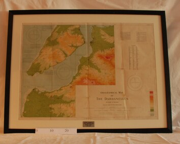
Map - Framed 1915 Map of Krithia, Gallipoli, 1915 Map of Krithia, Gallipolli, 1915
A framed topographical map of The Dardenelles produced from captured Turkish maps by the Egyptian Survey Department. The main feature is the Krithia battlefield area in 1915.Krithia Peninsula (The Dardenelles) World War One - 1915 Mapworld war one, 1915, egypt, map, dardenelles, krithia, survey department, turkey, battlefields -
 4th/19th Prince of Wales's Light Horse Regiment Unit History Room
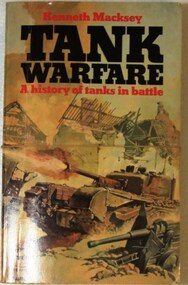
Book, Tank Warfare. A history of tanks in battle, 1976
Soft covered, 320 pp book. A survey of the tank in war from World War 1 through World War 2 and later conflicts.tank warefare, history, tank warefare, history -
 Federation University Historical Collection
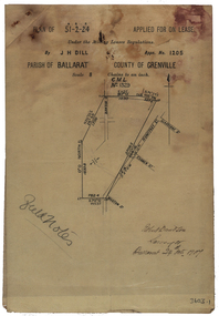
Plan, Parish Of Ballarat Mining Lease applied for by J.H. Dill, 1907, 24/10/1907
Removed from Catalogue No 3601.Lease, plan and field notes showing the survey for the New Kohinoor Comapny Lease No 1205. Scale: 8 chains to 1 inch (1:6336)new kohinoor, survey, robert davidson, j.h. dill, dill, mining, ballarat, new koh-i-nor -
 Bendigo Historical Society Inc.
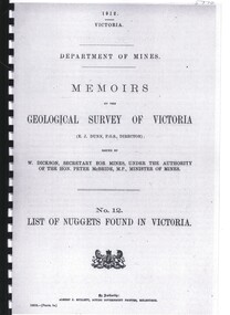
Book - LIST OF NUGGETS FOUND IN VICTORIA
Department of Mines, Memoirs of the Geological Survey Of Victoria No 12 List of Nuggets found in Victoria. 67 pages in spiral binder with clear plastic cover.victoria, history, gold mining, geology, and gold pros, victoria- gold mining-gold nuggetts -
 Bendigo Historical Society Inc.
Slide - RALPH BIRRELL COLLECTION: EIG SCHOOL, c1966
EIG School - Ralph Birrell Collection. - Construction of Latrobe Uni. C1966. Bendigo Institute of Technology, Engineering School, Applied Science. Surveying the grounds.Kodakeducation, tertiary, latrobe university bendigo, eig school - ralph birrell collection. - construction of latrobe uni. c1966. bendigo institute of technology, engineering school, applied science. surveying -
 Bendigo Historical Society Inc.
Map - PART OF ELLESMERE, 20/06/1875
Map: Re-survey of part of the Parish of Ellesmere, hand draughted Parish plan Reloacated to Map Drawer 5 on 22.9.2022. Hanging strip detached.map, bendigo, parish plan, ellesmere -
Victorian Aboriginal Corporation for Languages
Book, Edgar Morrison, The Loddon Aborigines : tales of old Jim Crow, 1971
This regional survey is the last of a trilogy, each of which deals with a particular aspect of living conditions and racial relationships in the Loddon watershed in the early Colonial days.maps, b&w photographsloddon -
 Victorian Aboriginal Corporation for Languages
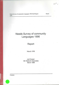
Book, Judi Cooper, Needs survey of community languages 1996 : report : March 1998, 1998
Report of Needs Survey of Community Languages, including, Methodology, Victoria, NSW, Queensland, Torres Strait Islanders, Western Australia, Northern Territory and summary. -
Whitehorse Historical Society Inc.
Book, Nunawading Youth Consultation 1981, 1982
Report on Consultation program including Youth festival, Phone-in, Seminar Day, Workers with Youth Consultation,, Open Mouth Survey. Coordinated by Sue BoggonReport on Consultation program including Youth festival, Phone-in, Seminar Day, Workers with Youth Consultation,, Open Mouth Survey. Coordinated by Sue Boggon.Report on Consultation program including Youth festival, Phone-in, Seminar Day, Workers with Youth Consultation,, Open Mouth Survey. Coordinated by Sue Boggonyouth, nunawading -
Whitehorse Historical Society Inc.
Map, Yarra River, n.d
Copy of fold-out map 'Loddon 25' included in 'Lilydale', by Grace Aveling. Based on T.H. Nutt's original survey of the Yarra River, 1839.aveling, grace, nutt, t.h., yarra river -
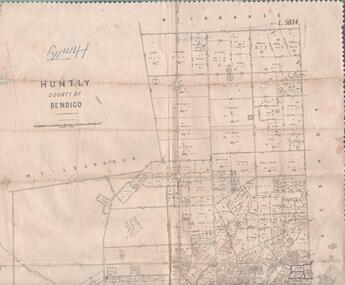 Bendigo Historical Society Inc.
Map - MAP. HUNTLY. COUNTY OF BENDIGO, 1912
Map. Huntly. County of Bendigo. Wellsford. Bagshot. Nerring. Wirrakee. Sandhurst. Photo-lithographed at the Department of lands and Survey. Melbourne byW. J. Butson -
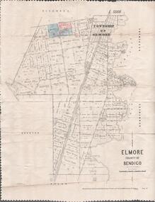 Bendigo Historical Society Inc.
Map - MAP. ELMORE COUNTY OF BENDIGO, 1918
Map. Elmore County of Bendigo. Diggorra. Burnewang. Ryunnymead. Egerton Photo-Lithographed at the Department of lands and Survey Melbourne, by W. J. Button. 4.7.18 -
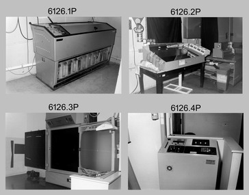 Bendigo Military Museum
Photograph - Photo Troop, Lithographic Squadron – Army Survey Regiment, Fortuna, Bendigo, 1986
This collection of 18 photos was most likely taken at Lithographic Squadron, Army Survey Regiment, Fortuna, Bendigo in 1986. The main tasks undertaken by technicians in Photo Troop were most likely enlargements, reductions and duplication of map reproduction material, and processing of aerial photography.This is a set of 18 photographs of Photo Troop personnel and equipment from Lithographic Squadron at the Army Survey Regiment, Fortuna, Bendigo, 1986. The photographs were on 35mm negative film and were scanned at 96 dpi. They are part of the Army Survey Regiment’s Collection. .1) - Photo, black & white, 1986, Film developer. .2) - Photo, black & white, 1986, Chromalin Proof equipment. .3) - Photo, black & white, 1986, KLIMSCH Commodore camera. .4) - Photo, black & white, 1986, KLIMSCH Commodore camera operator’s console. .5) - Photo, black & white, 1986, Film contact frame. .6) - Photo, black & white, 1986, Film processing chemicals. .7) - Photo, black & white, 1986, Unidentified technician. .8) - Photo, black & white, 1986, L to R: Unidentified technician, SPR Russell Pajank, SPR Carmel (Butler) Fauth. .9) - Photo, black & white, 1986, SPR Carmel (Butler) Fauth. .10) - Photo, black & white, 1986, SPR Carmel (Butler) Fauth. .11) - Photo, black & white, 1986, L to R: CPL Paul Baker, SGT Rob Bougumil. .12) - Photo, black & white, 1986, CPL Paul Baker. .13) - Photo, black & white, 1986, CPL Paul Baker. .14) - Photo, black & white, 1986, L to R: CPL Paul Baker, CPL Brian Paul. .15) - Photo, black & white, 1986, L to R: CPL Frank Lenane, SGT Rob Bougumil. .16) - Photo, black & white, 1986, CPL Brian Fauth. .17) - Photo, black & white, 1986, WO1 Trevor Osborne. .18) - Photo, black & white, 1986, L to R: SPR Kerron South, SGT Rob Bogumil.No personnel are identifiedroyal australian survey corps, rasvy, army survey regiment, army svy regt, fortuna, asr, litho -
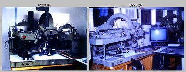 Bendigo Military Museum
Photograph - AUTOMAP 2 Production - Army Survey Regiment, Fortuna, Bendigo, c1986
This collection of 23 photos of map production on the AUTOMAP 2 computer-based system in Air Survey and Cartographic Squadrons, was most likely taken in 1986. The AUTOMAP 2 system was an upgrade to the AUTOMAP 1 system, comprising Intergraph graphic edit workstation terminals networked to VAX 750/785 main frame computers. Unlike AUTOMAP 1, operators could display digital topographic features on monitors for editing. Successful adaptation of this system meant RASvy was at the forefront of digital mapping/cartographic systems in Australia and overseas. The system comprised Input (Wild B8 Aviograph feature extraction) Raster Scanning (digitising from compilation sheets, Graphic Edit (cartographic completion) and Plot Verification Sub Systems. The system was operational from 1984 to its ‘Newheart’ upgrade in 1993. Throughout its life, the system was progressively refined with productivity gains, achieved from award winning technical development in-house by talented and innovative Army Survey Regiment personnel.This is a set of 23 photograph of AUTOMAP 2 production at the Army Survey Regiment at Fortuna, Bendigo, c1986. The photographs were on 35mm colour slides and were scanned at 96 dpi. Photos .5P and .6P are also printed on photographic and scanned at 300 dpi. They are part of the Army Survey Regiment’s Collection. .1) - Photo, colour, c1986, AUTOMAP 2 Production - Army Survey Regiment, Fortuna, Bendigo. c1986. .2) - Photo, colour, c1986, AUTOMAP 2 Wild B8 Aviograph stereoplotter. .3) - Photo, colour, c1986, AUTOMAP 2 Wild B8 Aviograph stereoplotter feature extraction, unidentified technician. .4) - Photo, colour, c1986, Wild B8 Aviograph stereoplotter feature extraction, LCPL Raelene (Munting) Brodie. .5) - Photo, colour, c1986, AUTOMAP 2 computer tape maintenance, SPR Steve Linane. .6) - Photo, colour, c1986, AUTOMAP 2 Graphic Edit Workstation, SPR Steve Linane. .7) to .8) - Photo, colour, c1986, AUTOMAP 2 Graphic Edit Workstation, unidentified technician. .9 to .10) - Photo, colour, c1986, AUTOMAP 2 Graphic Edit Workstation. .11) - Photo, colour, c1986, AUTOMAP 2 Graphic Edit Workstation feature coding and command menu. .12) - Photo, colour, c1986, AUTOMAP 2 high resolution computer monitor. .13) to .16) - Photo, colour, c1986, AUTOMAP 2 production output comparison to AUTOMAP 1. .17) to .18) - Photo, colour, c1986, AUTOMAP 2 computer system components. .19) - Photo, colour, c1986, AUTOMAP 2 Intergraph 7596 verification plotter. .20) - Photo, colour, c1986, AUTOMAP 2 Benson verification plotter, SPR Steve Coulson. .21) - Photo, colour, c1986, AUTOMAP 2 drainage, contour, roads and cultural digital data verification plot. .22) - Photo, colour, c1986, AUTOMAP 2 drainage, contour, roads and cultural digital data on computer monitor. .23) - Photo, colour, c1986, AUTOMAP 2 3D digital terrain model on computer monitor. .1P to .23P - Some of the equipment is annotated on the frame of the 35mm slides. .5P & .6P prints annotated incorrectly ‘Steve Lenane’. Correct spelling is - ‘Steve Linane’ royal australian survey corps, rasvy, army survey regiment, army svy regt, fortuna, asr, automap 2 -
 Bendigo Historical Society Inc.
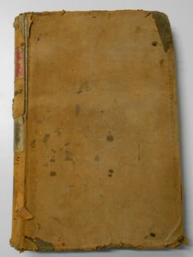
Document - LANDS OFFICE, CROWN LANDS SURVEYED AND SOLD SANDHURST DISTRICT, 1854 (?) onwards
Document: buff colour hard cover journal. Contains details of crown lands surveyed and sold. On LH page, town, suburban or country lands. RH page: auction, selection, price per acre, price and purchaser. Indexed by parish in front page. Two front pages cut out. On spine ' Index book' ' Lands and Survey' '06' 'E' ' Country' and 'Sales'Lands Officeplace, land sales, bendigo, lands office, land surveyed, land sold, sandhurst -
 Bendigo Historical Society Inc.
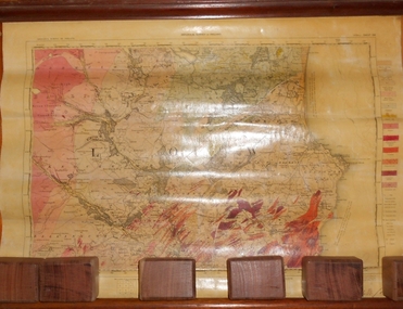
Map - MARKS COLLECTION: GEOLOGICAL MAP OF IRELAND
Rolled map on wooden hanger, wooden rail on bottom. On top of map: 'geological survey of Ireland' On bottom LH side: the geology of this map published June 1855 by Sir R.I. Murchison, Director General, J. Beebe Jukes Local Director, surveyed by T. Oldham. Map part of Lansell material. On back of map at top written in black pen 'Ireland'.person, bendigo, george lansell -
 Bendigo Military Museum
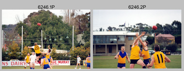
Photograph - Fortuna Falcons Football Team - Army Survey Regiment, Bendigo, 1995
This set of nine photographs was taken at an Army Survey Regiment Australian Rules Football social game at Golden Square Football Oval, Victoria in 1995. It is possible the game was between Product Construction Squadron and Data Acquisition Squadron, as it is apparent there are a mixture of Officers, WOs SGTs, CPLs and SPRs in each of the two teams. It is unlikely it was against another unit as it seems the CO LTCOL Duncan Burns and his counterpart are involved in the coin toss, and neither was wearing football boots. This set of nine photographs was taken at an Army Survey Regiment Australian Rules Football social game at Golden Square Football Oval, Victoria in 1995. The photographs were printed on photographic paper and are part of the Army Survey Regiment’s Collection. The photographs were scanned at 300 dpi. .1) - Photo, colour. 1995. All players unidentified. .2) - Photo, colour. 1995. L to R: Doug Willis, others unidentified. .3) - Photo, colour. 1995. L to R: unidentified (x2), Dough Willis, Rod Skidmore (yellow guernsey) .4) - Photo, colour. 1995. L to R: Bob Thrower, Rod Skidmore (yellow guernsey) others unidentified. .5) - Photo, colour. 1995. Greg Byers (Umpire) .6) - Photo, colour. 1995. L to R: Jim Ash (background), Rhys De Laine. .7) - Photo, colour. 1995. Jim Ash. .8) - Photo, colour. 1995. L to R: Rod Skidmore, Anthony Chamberlayne, unidentified (x3), Greg Byers (umpire), unidentified (x2), LTCOL Duncan Burns, unidentified, Rohan Hill, Bob Thrower, Doug Willis, Jim Ash, Mark Bird. .9) - Photo, colour. 1995. L to R: Jim Ash, Bob Thrower, Derek Percival, unidentified..1P to .9P – no annotationsroyal australian survey corps, rasvy, army survey regiment, army svy regt, fortuna, asr -
 Bendigo Military Museum
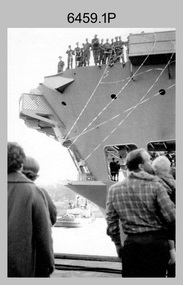
Photograph - A Section, 1st Topographic Survey Troop, Vung Tau, Vietnam, 1966
This is a set of 12 photographs of A Section, 1st Topographic Survey Troop taken from the 25th of May to the 12th of June 1966 during their deployment to Vung Tau, Vietnam. Led by OC CAPT Bob Skitch, the ten personnel from A Section 1st Topo Svy Tp and six personnel from supporting units were the first contingent from the Royal Australian Survey Corps deployed to provide topographic support to the Australian Task Force in Vietnam. They arrived in Saigon, Vietnam on the 10th of June 1966 enroute to the Australian Reinforcement Unit (ARU) “back beach” camp in Vung Tau. The ten RA Svy technical personnel from 1st Topo Svy Tp deployed were: WO2 David Christie, SGT Stan Campbell, SGT Dave King, CPL Jim Roberts, CPL Dennis Duquemin, CPL Des Ceruti, SPR Derek Chambers, SPR Brian Firns, SPR Joe O’Connor and SPR Ron Smith. External personnel deployed were: WO2 Snow Rollston from Northern Command Field Survey Unit, T/CPL Peter Clarke – orderly room corporal, T/CPL Alan Carew – Technical Storeman, SPR Stan Johns – Map Storeman, SPR Boots Campbell – batman/driver and PTE BNF Brunning – cook. The ship featured in photos .1P and .2P was the aircraft carrier HMAS Sydney on its 4th voyage to Vietnam. On board were SGT Stan Campbell and SPR Brian Firns, tasked to manage A Section’s stores and equipment. The rest of A Section deployed to Vietnam by air on the chartered Qantas 707B ‘City of Longreach'. A Section’s main tasks were to establish a Theatre Grid, map compilation and map revision; Engineer Survey Support in the camp and to the civil community; give assistance to the Cordon Search Missions by producing large scale plots from aerial photos with every house and fence etc plotted; and then reproduce these by silk screening usually, within a 24-hour period. RA Svy’s support concluded with the withdrawal of Australian troops from Vietnam in 1972. More information on the A Section, 1st Topographic Survey Troop and the Army Survey Regiment’s supporting role is provided in pages 89 to 94 of Valerie Lovejoy’s book 'Mapmakers of Fortuna – A history of the Army Survey Regiment’ ISBN: 0-646-42120-4.This is a set of 12 photographs of A Section, 1st Topographic Survey Troop (1st Topo Svy Tp), taken from the 25th of May to the 12th of June 1966 during their deployment to Vung Tau, Vietnam. The black and white photographs were printed on photographic paper and are part of the Army Survey Regiment’s Collection. The photographs were scanned at 300 dpi. .1) &.2) - Photo, black & white, 1966. HMAS Sydney departing Woolloomooloo wharf en-route to Vietnam. .3) - Photo, black & white, 1966. A Section 1 Topo Svy Tp relaxing in a bar before deployment. OC CAPT Bob Skitch in centre of photo. .4) - Photo, black & white, 1966. Unidentified A Section 1 Topo Svy Tp personnel and troops from other units relaxing in a bar before deployment. .5) - Photo, black & white, 1966. A Section 1 Topo Svy Tp personnel arrival by bus at Saigon (Tan Son Nhut) Airport. OC CAPT Bob Skitch 4th from right. .6) - Photo, black & white, 1966. A Section 1 Topo Svy Tp personnel boarding the USAF Hercules aircraft enroute from Saigon (Tan Son Nhut) Airport to Vung Tau Airfield. OC CAPT Bob Skitch on left. .7) - Photo, black & white, 1966. A Section 1 Topo Svy Tp personnel and troops from other units boarding the USAF Hercules aircraft enroute from Saigon (Tan Son Nhut) Airport to Vung Tau Airfield. .8) & .9) - Photo, black & white, 1966. A Section 1 Topo Svy Tp personnel arrive at the Australian Reinforcement Unit (ARU) “back beach” camp. .10) - Photo, black & white, 1966. A Section 1 Topo Svy Tp personnel in oppressive conditions work on map products. .11) - Photo, black & white, 1966. Group photo of A Section 1 Topo Svy Tp. OC CAPT Bob Skitch on far right. .12) - Photo, black & white, 1966. Group photo of A Section 1 Topo Svy Tp. OC CAPT Bob Skitch 3rd from right.Annotated with the photo set - ‘ DET 1 Topo Svy Tp Vung Tau 25 May to 12 of Jun 66’royal australian survey corps, rasvy, army survey regiment, army svy regt, fortuna, asr, 1st topographical survey troop -
 Ringwood and District Historical Society
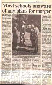
Newspaper, Scrapbook Clipping, Library Collection, Ringwood, Victoria, `
``Newspaper clipping from the "Mail" 5-11-96 P9. Most schools unaware of any plans for merger.Wih the State Government's position well known on school mergers, "The Mail" surveyed Maroondah's schools on the same subject. Most of the surveyed schools said they knew nothing of any planned mergers, or they did not wish to comment. No school said they were in favour of mergers in Maroondah. ` -
 The Beechworth Burke Museum
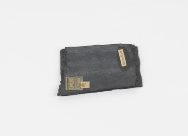
Geological specimen - Slate (Metamorphic), Unknown
This particular specimen was found in the Moorabool Slate quarries in Victoria. The Moorabool Slate quarries was established in the 1860’s by a company of Welshmen with a crew of six who purchased land by the riverside to mine for slate. Under the promise of adding to existing recourses the crew mined the slate which was used for paving and roofing. Slate is a fine-grained, low-grade metamorphic rock that is formed by the transformation of mudstone, shale or sometimes volcanic ash under low pressure and temperatures. It dark colour is due to carbonaceous material or to finely divided iron sulphide. It is believed that Evan Rowlands and Theophilus Williams of Ballarat were the first to discover the slate veins. Slate is a one of the most common natural stones in general use. Being used as paving, flooring, roofing and more. However, its history of being mined in Australia is not common as it is considered that the best places to mine slate is Spain and parts of the United Kingdom. This specimen is part of a larger collection of geological and mineral specimens collected from around Australia (and some parts of the world) and donated to the Burke Museum between 1868-1880. A large percentage of these specimens were collected in Victoria as part of the Geological Survey of Victoria that begun in 1852 (in response to the Gold Rush) to study and map the geology of Victoria. Collecting geological specimens was an important part of mapping and understanding the scientific makeup of the earth. Many of these specimens were sent to research and collecting organisations across Australia, including the Burke Museum, to educate and encourage further study.A somewhat rectangular foliated metamorphic rock composed of quartz, sericite and minerals from the chlorite group that make up the compounds of slate. The rock is dark grey almost black.Geological survey / R S / Loc Moorabool /Slate quarries / 1/4 sheet | 78 | Roofing Slate /burke museum, beechworth, geological, slate, metamorphic, slate (metamorphic), geological specimen, slate specimen, indigo shire -
 Bendigo Military Museum
Manual - TM5 - 245: (US) Department of the Army Technical Manual - Map Reproduction, US Department of the Army, United States of America, War Office, 10 Sep 1956
Nine Chapters describing all aspects of Map Reproduction. 224 pages, including 8 appendices, glossary and indexA soft covered military manual, 224 pages of text, diagrams and annotated photographs"AHQ Survey Regiment" stamped inside front and back covers. Number "149" handwritten inside front cover.royal australian survey corps, rasvy, fortuna, army survey regiment, army svy regt, asr, mapping -
 Bendigo Historical Society Inc.
Map - JACK FLYNN COLLECTION: TARNAGULLA, 13/05/1922
Map: Parish of Tarnagulla . This Item is in very poor condition.By Authority, A. J. Mullen, Government Printer, Melbourne. Lithographed at the Department of Lands and Survey, Melbourne by W. J. Butsonmap, gladstone, parish plan, tarnagulla -
 Bendigo Historical Society Inc.
Map - JACK FLYNN COLLECTION: TOWNSHIP OF STANHOPE, December 1950
Map: Township of Stanhope, Parish of Girgarre, County of Rodney. Parish plan.By Authority J. J. Gourley, Government Printer, Melbourne. Drawn and Reproduced at the Dept, of Lands and Survey, Melbourne, Victoria.map, rodney, township, stanhope -
 Bendigo Historical Society Inc.
Map - JACK FLYNN COLLECTION: SANDHURST SHEET 6, January 1947
Map: Parish of Sandhurst Sheet 6. County of Bendigo. Parish plan.By Authority J. J. Gourley, Government Printer, Melbourne. Drawn and Reproduced at the Dept, of Lands and Survey, Melbourne, Victoria.map, bendigo, parish plan, sandhurst sheet 6 -
 Bendigo Historical Society Inc.
Map - JACK FLYNN COLLECTION: SANDHURST SHEET 2, January 1947
Map: Parish of Sandhurst Sheet 2, County of Bendigo. Parish plan.By Authority J. J. Gourley, Government Printer, Melbourne. Drawn and Reproduced at the Dept, of Lands and Survey, Melbourne, Victoria.map, bendigo, parish plan, sandhurst sheet 2 -
 Bendigo Historical Society Inc.
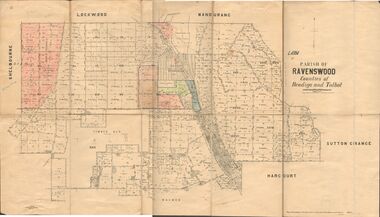
Map - JACK FLYNN COLLECTION: RAVENSWOOD, 12/12/1922
Map: Parish of Ravenswood, Counties of Bendigo and Talbot. Parish plan.By Authority A.J. Mullet Government Printer Melbourne. Photo Lithographed at the Department of lands and Survey, Melbourne by W.J. Butsonmap, bendigo, parish plan, ravenswood -
 Bendigo Historical Society Inc.
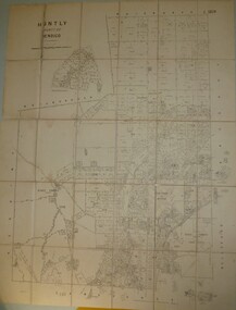
Map - JACK FLYNN COLLECTION: HUNTLY, 8/09/1921
Map: Parish of Huntly, County of Bendigo. Parish plan.By Authority, Govt., Printer. A. J. Mullett. Photo Lithographed at the Department of Land and Survey Melbourne By W. J. Butsonmap, bendigo, parish plan, huntly -
 Bendigo Historical Society Inc.
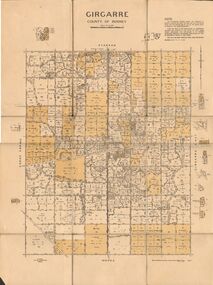
Map - JACK FLYNN COLLECTION: GIRGARRE, 14/10/1943
Map: Parish of Girgarre. County of Rodney. Parish plan.By Authority, H.E. Daw, Government Printer Melbourne. Drawn and produced at the Dept of Lands and Survey, Melbourne, Victoria. 14.10.1943map, rodney, parish plan, girgarre, county of rodney