Showing 2559 items
matching aerial
-
 Eltham District Historical Society Inc
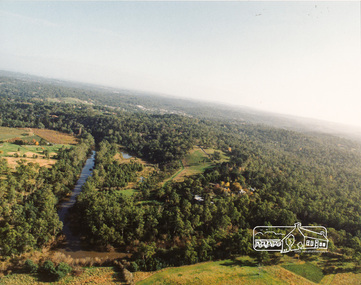
Photograph, Yarra River, Sweeneys flats, 1994c
Colour photogrpah of oblique aerial view looking east over Yarra River and Sweeneys flats c.1994sweeneys lane, yarra river, culla hill, thomas sweeney, aerial photographs -
 Federation University Historical Collection
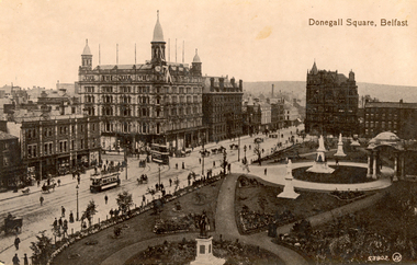
Postcard - Black and white, Valentine, Donegall Square, Belfast
WW1 Holmes Family souvenirAustralian soldier's WW1 souvenirBlack and white postcard showing an aerial view of Donegall Square in Belfast. Trams, horses and people are evident on the streetschatham-holmes family collection, belfast, ireland -
 Federation University Historical Collection
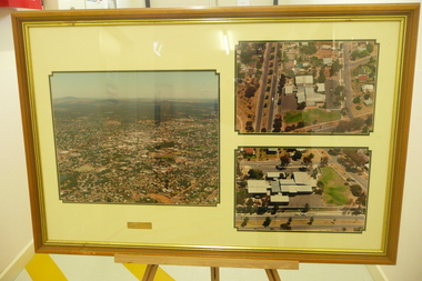
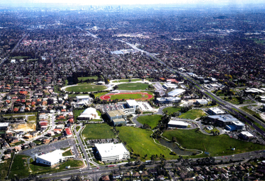
Photograph - Photograph - Colour, Federation University Gippsland Campus, c1995, c1995
The following information was the preface of the 1985 GIAE handbook: The Gippsland institute of Advanced Education was established by an Order-in-Council in September, 1968, but, owes its origin to engineering diploma courses established in 1928 to service the developing electrical industry. The Council of the Institute includes members of the Gippsland community who are prominent in industry, commerce, education and the professions, the Director of the institute, the representative of the academic staff, of general staff, of students and of the Convocation of the Institute. In 1972 the Institute occupied the first of its permanent buildings on a large campus in rural surroundings near the township of Churchill, ten kilometres south of Morwell and one hundred and sixty kilometres east of Melbourne. Engineering laboratories are temporarily located in buildings on the site of the Yallourn College of TAFE at Newborough and they will be consolidated on the Churchill campus by the end on 1985. In 1974 new buildings were completed under a self-help program to house the School of Visual Arts. A building complex to provide the first stages of the permanent library and the Union, and accommodation for the School of Business and Social Sciences was completed in 1976. An Education building, an Applied Science building and student residential buildings for 108 student places were completed at the beginning on 1976. The Binishell, a multi-purpose facility was completed in 1980. On its establishment, the Institute assumed responsibility for the diploma courses which were previously offered by the Yallourn Technical College. These were diploma in Civil, Electrical, and Mechanical Engineering, Applied Chemistry, and Business, all of which were recognised by the appropriate professional bodies. The Gippsland Institute of Advanced Education is the only centre of Higher Education east of Melbourne and offers a range of vocational courses at associate diploma, diploma, degree, graduate degree and master levels to meet the educational needs of the Gippsland regions. The institute also has a very large commitment to a program on external studies. Federation University Australia was established on 1 January 2014. Formerly known as the University of Ballarat, its enabling legislation was the University of Ballarat Amendment (Federation University Australia) Act 2013. Although formally created as a University in 1994, the University of Ballarat had a lineage back to 1870 with the establishment of the School of Mines Ballarat, making it the third institution of higher learning to be established in Australia and the first to be established in regional Australia. On 1 January 1994, Ballarat University College became the University of Ballarat and in 1998 the University merged with three TAFE Institutes to become a dual sector institution with multiple campuses. On 1 January 2014, the University of Ballarat amalgamated with the Monash University Gippsland Campus to form Federation University Australia. The Gippsland Campus also had a long lineage dating back to 1928 with the establishment of the Yallourn Technical School which became a predecessor institution to the Gippsland College of Advanced Education formed in 1968. In 1990, it was renamed the Monash University College and in 1993 became the Gippsland Campus of Monash University. Large photograph adhered to foamcore showing an aerial view of the Federation University Gippsland Campus at Churchill, Victoria as it was c1995.churchill, gippsland campus, gippsland institute of advanced education, federation university, yallourn, morwell, binishell -
 Glenelg Shire Council Cultural Collection
Photograph - Photograph - Aerial view of Thomas Borthwick and Sons abattoir and Walock Swamp, Nov-55
Port of Portland Authority archives.Front: (no inscriptions) Back: 'AIRSPY PHOTO' CD PRATT 86 McCracken St ref No2/B/73 Essendon Phone Fx 2840 Victoria Australiaport of portland archives, tb and s abattoir, walock swamp -
Glenelg Shire Council Cultural Collection
Photograph - Photograph - Portland and the harbour, n.d
Port of Portland Authorityport of portland archives, portland harbour, fuel storage tanks -
Glenelg Shire Council Cultural Collection
Photograph - Photograph - aerial view of Portland, n.d
Port of Portland AuthorityBack: fd001- pencilport of portland archives, aerial photography, portland harbour -
Glenelg Shire Council Cultural Collection
Photograph - Photograph - aerial view of Portland Harbour, 1958
Port of Portland Authority ArchivesBack: Purple stamp - 14 Jan 1958 Harbour from air - blue biroport of portland archives, aerial photography, portland harbour -
Glenelg Shire Council Cultural Collection
Photograph - Photograph - Aerial shot of rock wall Dutton Way, n.d
Port of Portland Authority Archivesport of portland archives, dutton way -
Glenelg Shire Council Cultural Collection
Photograph - Photograph - aerial view of Portland Harbour, 1958
Port of Portland Authority ArchivesBack: Purple Stamp - 14 Jun 1958 Harb-009 L 49 pencilport of portland archives, 1950s, 1958, aerial photography, portland harbour -
Glenelg Shire Council Cultural Collection
Photograph - Photograph - Early Shipping: Ocean/Railway Pier, n.d
Port of Portland Authority Archivesport of portland archives, portland harbour, ship berthed, ocean pier, k s anderson -
Glenelg Shire Council Cultural Collection
Photograph - Photograph - Main Breakwater Construction, n.d
Port of Portland Authority Archivesport of portland archives, portland harbour, land reclamation, wharf construction, breakwater, battery point, aerial closeup -
Glenelg Shire Council Cultural Collection
Photograph - Photograph - View of port and facilities, c. 1974
Port of Portland Authority archives.Front: (no inscriptions) Back: (no inscriptions)port of portland archives, portland harbour, k s anderson, no6, no5 berths -
Glenelg Shire Council Cultural Collection
Photograph - Photograph - Quarry, Cape Grant, n.d
Port of Portland Authority Archivesport of portland archives -
 Bendigo Historical Society Inc.
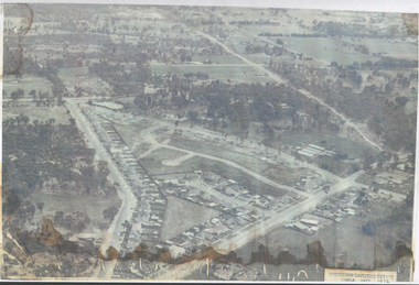
Photograph - Aerial View Sydenham Gardens Estate Circa 1972
The Sydenham gardens were set up in 1854 to provide an area of relaxation for diggers. A German, Mr Kraemer, made extensive plantings of ornamentals and fruit trees. The area expanded to 11 acres in 1865 and 25 acres in 1916. T O Hunter owned the gardens from about 1896 and initially it was used for many types of entertainment including, picnics, festivals and sporting events. It was situated off Holdsworth Road in what is now Jackass Flat. T O Hunter was a cordial manufacturer in Macrae Street, who was prominent in many sporting areas. He was President of the Bendigo Coursing Association and raced both dogs and horses. By the time he sold the gardens in 1936 to Mr Muir, he was using the gardens as grazing for his horses.Photograph: aerial view of Sydenham Gardens Estate Circa 1972 , as noted on photo Colour photo, A5 sizephoto sydenham gardens estate, aerial photo -
 Bendigo Historical Society Inc.
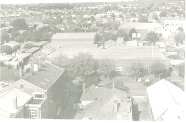
Photograph - BENDIGO NORTH P.S. COLLECTION: AERIAL PHOTOGRAPHS, 1996
3 Large aerial photographs of Bendigo North Primary School under glass in a timber frame. Deframed 2022photograph, building, bendigo north school -
Port Melbourne Historical & Preservation Society
Photograph - Aerial view of West Gate Bridge, Oct 1990
Cut from the 1990 City of Melbourne Strategy PlanPage from 1990 City of Melbourne Strategy Plan with aerial photograph of West Gate Bridge and Fishermen's Bendtown planning, engineering - bridges -
Port Melbourne Historical & Preservation Society
Photograph - Aerial view over Yarra River and Port Melbourne, 18 Jun 1940
Aerial photograph overlooking the Yarra River with Port Melbourne in the middle. Background - Williamstown Road is visible at the top of the picture.piers and wharves - miscellaneous, built environment - commercial, malcolm moore ltd, north wharf, south wharf, nordfest -
 Bendigo Historical Society Inc.
Photograph - LONG GULLY HISTORY GROUP COLLECTION: AERIAL PHOTOS
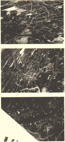
Copies of three dark aerial photos of suburban areas, possibly Long Gully. Photos show streets and buildings.bendigo, history, long gully history group, the long gully history group - aerial photos -
 Bendigo Historical Society Inc.
Photograph - HANRO COLLECTION: AERIAL VIEW OF HANRO BENDIGO
Photograph. Black and White aerial view photograph of the Hanro Knitting Mills, Hargreaves Street, Bendigo, in the centre of the photo.organization, business, hanro knitting mills, hanro -
 National Vietnam Veterans Museum (NVVM)
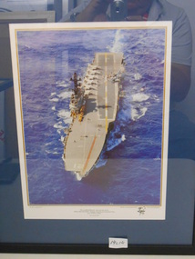
Photograph, HMAS Melbourne
In a black frame there is a coloured photograph of an aerial shot of HMAS Melbourne to celebrate the 75th Anniversary of The Royal Australian NavyR21r.a.n., photograph, hmas melbourne -
Tatura Irrigation & Wartime Camps Museum
Photograph - aerial, Arthur J. Underwood, Kyabram, Tatura 1959, January 1959
J. Underwood was photographer for Kyabram Free PressBlack and white aerial photograph of Tatura township taken in 1959 by J. Underwood, Kyabram. Framed and under glass.j. underwood -
 Wangaratta Art Gallery
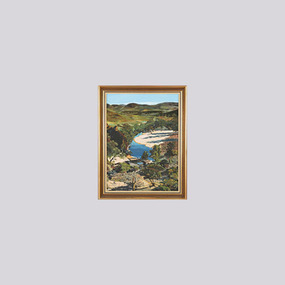
Painting, Robert Horne, Overlooking the Howqua River, 1975
Rural City of Wangaratta Collection, Wangaratta Art Prize 1976.An aerial landscape depicting the Howqua River painted in synthetic polymer in shades of green, yellow, blue, brown, and white.Obverse: R HORNE 75/ (bottom right corner)wangaratta art gallery, robert horne, landscape, painting, howqua river -
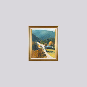 Wangaratta Art Gallery
Painting, Len Pawluk, Afternoon Walhalla, 1981
Rural City of Wangaratta Collection, Wangaratta Art Prize Grand Winner 1981.A aerial landscape of a rural road, painted in oil using a colour palette of blue, green, white, yellow, and brown.Obverse: L Pawluk/ (bottom left corner)wangaratta art gallery, len pawluk, landscape, rural, painting, walhalla -
Stawell Historical Society Inc
Archive - Handbook, Aunde Employee Induction Handbook, 18/12/2003
Plastic Cover over book. Black Card cover. B/W. Photo aerial view Aunde BuildingsAunde Australia Oty Ltd. Employee Induction Handbook -
Whitehorse Historical Society Inc.
Map, Deep Creek Road, Mitcham, c1975
Enlargement of aerial photograph of area bounded by Dalmar Road, Cray Road, Glenvale Road and Maroondah Highway, MitchamEnlargement of aerial photograph of area bounded by Dalmar Road, Cray Road, Glenvale Road and Maroondah Highway, MitchamEnlargement of aerial photograph of area bounded by Dalmar Road, Cray Road, Glenvale Road and Maroondah Highway, Mitchamcray road, donvale, glenvale road, donvale, maroondah highway, mitcham, dalmor road, mitcham, deep creek road, mitcham, aerial photographs -
Whitehorse Historical Society Inc.
Legal record - Land Title, Springvale Road, 1960
Aerial photograph of cnr. Springvale Road and Burwood Highway, south past Highbury Road and east to Vermont South.Aerial photograph of cnr. Springvale Road and Burwood Highway, south past Highbury Road and east to Vermont South.Aerial photograph of cnr. Springvale Road and Burwood Highway, south past Highbury Road and east to Vermont South.aerial photographs, springvale road, burwood east, burwood highway, burwood east, highbury road, burwood east, vermont south -
 Whitehorse Historical Society Inc.
Photograph, Tally Ho Industrial Park, C.1995
Aerial Photo of Tally Ho Industrial Park. East Burwood Reserve and the Bill Sewart Athletic Track is in centre.tally ho industrial park, lend lease development pty ltd, east burwood reserve, bill sewart athletic track -
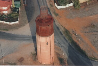 Rutherglen Historical Society
Photograph - Aerial Images, c2000
The Rutherglen 'Big Wine Bottle', once a water tower to supply the town's water, is now kept as a tourist attraction.Colour aerial photograph of the old Rutherglen water tower with the structure on top to make it look like a wine bottle.water tower, water supply, rutherglen winebottle -
 Whitehorse Historical Society Inc.
Photograph, Burwood Technical School
Burwood Technical School was located on the south west corner of Middleborough and Elgar RoadsStrip of four coloured aerial photo of the Burwood Technical School Buildings taken sometime between 1986 and 1992.schools, burwood technical school -
Port Melbourne Historical & Preservation Society
Photograph - Aerial view, The Boulevard Upgrade Sandridge Beach, Oct 2003
Shows an aerial photographic view of Garden City with five smaller pictures of different locations relevant to the upgrade of the boulevard.Existing conditions the Boulevard Upgrade Sandridge Beach 1:500 October 2003 City of Port Phillip.local government - city of port phillip, fred jackson reserve, advertising, perce white reserve, frederick charles jackson, perce mcguire white, perce white