Showing 3431 items matching "distance"
-
 Lakes Entrance Historical Society
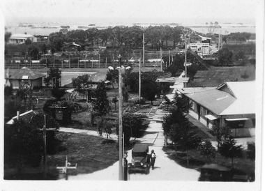
Photograph - Whiter's Camp Park, 1928c
Also postcard size black and white same scene but larger view with two vehicles, with inscription-General view Lakes camping park showing homestead.|Larger copy has the inscription Beautiful view of park from Whiters Lookout Tower.Black and white photograph of Whiters Park, showing residence and office, gardens, tennis court, early model car by the petrol bowser, electric lights on tall poles. Opposite park entry is Aults Motor Engineer, scattered cottages. In distance is Cunninghame Arm, sand hummocks and ocean. Lakes Entrance Victoriaresort, township, transport, recreation -
 Kiewa Valley Historical Society
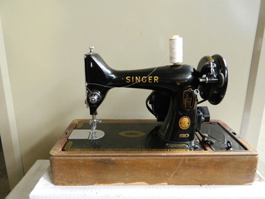
Sewing Machine
Sewing machines were used by some ladies to mend and make clothes for the family as shops were some distance away and bought clothes were much more expensive. The sewing machines were also used to sew items for fund raising e.g.. Church and School fetes.Used in the Kiewa Valley.The machine has a brown wood veneer base and a lid with a metal handle in the centre of the top. There is a long screw that fits in a hole at the top of the lid. The screw can be lifted out and used to open and take off the lid. Inside there is a black metal machine which is fitted onto the wooden base. There is a compartment in the base, right of the wheel of the machine, which holds an instruction manual and a tube of ""Singer" lubricant for electric machines". The light, above the needle is covered by bakelite. A leather belt runs around the wheel on the right to enable the machine to run. There is a foot pedal and an electric cord attached."Singer Manufacturing Company" - gold embossed "No. EL 249 355" - oval disc "99K" - disc "Singer Manfg. Co. - discsewing machine; singer manufacturing company; kiewa valley -
 Kiewa Valley Historical Society
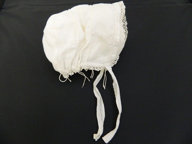
Baby's Bonnet
Due to relative long distance to haberdashery stores majority of children's garments were hand made by a local talented seamstress or mother/relative. This bonnet is very similar is style and fashion to other children's clothing in KVHS collection which indicates this was made during the early 1900's. This has good historical significance because it shows the fashions during the early 1900's which baby bonnets were made by women of the Kiewa Valley. This item also has good interpretive capacity as it adds to the other babies clothing in the KVHS collection and therefore increases the interpretive capacity for the children's clothesCream muslin with 1 cm wide lace around the face and neck. Pin tucks threaded with fine string and 2 tape ties 13 cm long. Also string used to gather the neck edge.baby. bonnet. christening. clothing. infant. -
 Kiewa Valley Historical Society
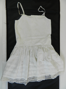
Petticoat Child
This petticoat is demonstrative of home made infant undergarment clothing in the early 1900. Distance to and from commercial haberdashery store was too far to fit out young girls especially if the are undergarments. Mothers and other family members had the seamstress talent to make clothes that are not in full view of anyoneHistorically these undergarments have no fashion relevance for the younger fashion scene and this garment is an example of the self sufficient supply of home made articles. This was especially so within the Kiewa Valley and surrounds. Fashion in Australia and more so in areas with little or no access to overseas or city merchandise lacked "modern fashionable" clothes e.g. the latest from England and Paris. This region was and still is a rural backdrop of clothes that fit into the type of life and work of the society it holds.Cotton petticoat, white, three buttons on top back, 8mm wide straps of cotton tape. Gathered skirt with triple row of Rick Rack on the bottom edge and three pintucks, 17mm wide, on the lower edge of skirt. Garment is completely hand stitchedchildren's underwear, female underwear, dressmaking, handcraft, costume, clothing -
 Queenscliffe Maritime Museum
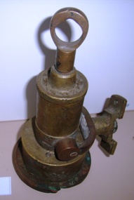
Tool - Navigation, ship's Log, 25 May 2011
A Ship's Log looked very similar to a torpedo but was used to measure the speed of a ship. When dragged behind the vessel, movement of water past the propeller caused it to rotate, turning the small needle dials to record the distance and speed travelled. https://museumsvictoria.com.au/immigrationmuseum/resources/journeys-to-australia/Ship's Log Display HeadWalkers Cherub 111 ships lognavigation, speed, knot, chip log, log, thomas walker and son -
 Sunbury Family History and Heritage Society Inc.
Photograph, Jacksons Creek
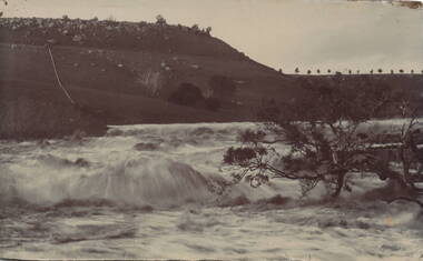
The photograph of the waterfall tumbling over rocks in the Jacksons Creek are a feature downstream from the Macedon Street bridge and Craiglee when the there has been high rainfall. The steep escarpment on the LHS leads to Jacksons Hill and the line of trees in the distance are growing along Macedon Street (Sunbury Road).After heavy rainfall, Jacksons Creek rises suddenly and small trickles over the rocky outcrops become fast flowing waterfalls.A non-digital sepia photograph backed onto thick cardboard of a waterfall tumbling over rocks in a river with a high escarpment rising up from the watercourse. There are rocky outcrops across the hillside with a pipe down the hillside. jacksons creek, jackson hill, waterfalls, rivers -
 Bendigo Military Museum
Photograph - Johnson Ground Elevation Meter (JGEM) Survey Vehicle - Army Survey Regiment, Fortuna, Bendigo, c1960s
This is a set of 16 photograph of the Royal Australian Survey Corps’ Johnson Ground Elevation Meter (JGEM) Survey Vehicle taken at the Army Survey Regiment, Fortuna, Bendigo. The JGEM vehicle was extensively used by RA Svy within Australia from the late 1960s. A limited number of Ground Elevation Meter (GEM) station wagon type vehicles were manufactured by General Motors Corporation (GMC) in the USA for the United States Geological Survey, Canada’s mapping agencies, RA Svy and National Mapping (Natmap). The GEM was a four-wheel drive, four-wheel steer vehicle. Four-wheel steering was necessary to avoid systematic errors caused by non-tracking of front and rear wheels on conventionally steered vehicles. The manufacturer substituted the rear axle with a front axle and connected them to form the four-wheel steering mechanism. The two Australian GEM vehicles, referred to as Johnson GEMs (JGEMs) were converted into right-hand drive. After delivery in 1964, acceptance Natmap and RA Svy testing and operator training was undertaken at the Army's School of Military Survey located at Balcombe, Victoria. A small fifth wheel was mounted on a cantilever arm suspension midway between the front and rear wheels on the right side of the vehicle. It was lowered to and raised from its operating position by use of a constant pressure air cylinder. A telescopic bar, suspended between the front and rear axles, provided the reference datum for the angle measurement. The wheel provided the velocity or distance signal through a pulse generator system. A sensitive pendulum mounted on this bar provided the angle measurement for each minute distance traversed. The JGEM contained electromechanical instruments used to determine relative elevations, by trigonometric principles, along a traversed path. These relative elevations were obtained through apparatus which measures the instantaneous angle of inclination of the road and the instantaneous velocity of the meter along such a path. Road routes over which the JGEM operated were planned so that each started and ended as near as practicable to an existing point of known elevation (formally referred to as a level traverse bench mark). The difference in height from the bench mark and the road surface alongside the JGEM’s fifth wheel was measured with a level and staff. Along each route, mapping control photo reference points where new elevation values were required were identified on aerial photographs. Under favourable conditions it was possible to survey as much as 160km in an ordinary working day. The first of RA Svy’s JGEM operations was undertaken in 1:250,000 scale map areas of Queensland. CPL John Hook was the JGEM’s main operator in the early 1970s undertaking operations covering 1:250,000 scale map blocks over northern Victoria and central NSW, each requiring 36 points (9 runs of photography and 4 points across. SPR Lyn Thompson and SPR Bob McDonagh teamed with CPL Hook on some of these JGEM operations. When RA Svy was integrated into the Royal Australian Engineers in 1996, the JGEM vehicle with the Survey Corps collection was donated to its museum. It is believed to be the last of the original manufactured fleet in existence. The JGEM has undergone extensive refurbishment to achieve roadworthiness and is currently housed at The Australian Army Museum of Military Engineering, Hoslworthy Barracks, NSW. It can be viewed by making an appointment with the museum’s curator.This is a set of 16 photograph of the Royal Australian Survey Corps’ Johnson Ground Elevation Meter (JGEM) Survey Vehicle taken at the Army Survey Regiment, Fortuna, Bendigo. The photographs were on 35mm slide film and were scanned at 96 dpi. They are part of the Army Survey Regiment’s Collection. .1) - Photo, colour, c1960s, Johnson Ground Elevation Meter (JGEM) Survey Vehicle .2) - Photo, colour, c1960s, JGEM instrumentation, on-board computer. .3) - Photo, colour, c1960s, JGEM instrumentation. .4) - Photo, colour, c1960s, JGEM instrumentation, on-board computer. .5) - Photo, colour, c1960s, JGEM tyre pressure controller .6) - Photo, colour, c1960s, JGEM rear doors, SGT Geoff Briggs. .7) - Photo, colour, c1960s, JGEM 5th wheel distance/angle measurement device in lowered position, SGT Geoff Briggs. .8) - Photo, colour, c1960s, JGEM 5th wheel distance/angle measurement device in lowered position. .9) & .10) - Photo, colour, c1960s, JGEM tyre pressure system, SGT Geoff Briggs. .11) - Photo, colour, c1960s, JGEM tyre pressure system. SGT Geoff Briggs. .12) - Photo, colour, c1960s, JGEM levelling scope, levelling staff, unidentified technicians. .13) & .14) - Photo, colour, c1960s, JGEM levelling scope, unidentified technician. .15) & .16) - Photo, colour, c1960s, probably survey operation adjusted height plotted on block base sheet. .1P to .16P - Some of the equipment is annotated on the frame of the 35mm slides.royal australian survey corps, rasvy, army survey regiment, army svy regt, fortuna, asr, surveying -
 Bendigo Military Museum
Photograph - Royal Australian Survey Corps Surveyors in the Field – Northern Territory and Queensland, 1959 – 1960
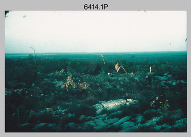
This is a set of 10 photographs of surveyors and support staff in the field undertaking duties in the Northern Territory and North Queensland in 1959 – 1960. The surveyors were employed in the establishment of mapping and geodetic control. In this era surveyors used theodolites to observe horizontal and vertical angles and tellurometers to measure base line distances between survey stations. Laplace survey observations seen in Photo .1P was a series of precise observations carried out at geodetic survey stations to determine astronomic latitudes, longitudes and azimuths to achieve maximum precision in the survey network. Laplace observations were necessary in a geodetic network at every 6th survey station, however the National Mapping Council specified at this time the spacing would be ideally between 4-6 survey stations. The cairn shown in photo .4P was built by RASvy as a landmark over a trigonometric survey station. It was dismantled in 1960 to enable re-occupation and survey observations. It was not restored to the condition shown in the photo.This is a set of 10 photographs of surveyors and support staff in the field undertaking duties in the Northern Territory (NT) and Queensland (QLD) in 1959 – 1960. The photographs were printed on photographic paper and are part of the Army Survey Regiment’s Collection. The photographs were scanned at 300 dpi. .1) - Photo, colour, 1959. Tony Slattery occupying a Laplace survey station on a hill in the Mount Young area of the NT. .2) - Photo, colour, 1959. Surveyors’ camp in the Mount Young area of the NT, L to R: Spencer Snow and Tony Slattery. .3) - Photo, colour, 1959. Surveyors’ camp in the Peckman Hill area, near Katherine in the NT. .4) - Photo, colour, 1959. Cairn on Trig Hill, Borroloola, NT. Built by Spencer Snow, Tom Royle and Jack McCabe. .5) - Photo, colour, 1959. Survey party taking a break next to their Austin Champ vehicle, in transit between Katherine, NT and Wyndam WA. L to R: Tony Slattery, Dave Owens, John Van De Graff. .6) - Photo, colour, 1960. Surveyors’ camp between Mount Isa, QLD and Borroloola, NT. L to R: Pat Cox and John Van De Graff prepare their meal on an open fire. .7) - Photo, colour, 1960. Surveyor - Dennis Woods undertaking survey observations, using MRA1 tellurometer to measure base-line distances NW of Mount Isa, QLD. .8) - Photo, colour, 1960. Unidentified surveyors assessing recovery of their stalled Studebaker truck vehicle after attempting a water crossing in the NT. .9) - Photo, colour, 1960. Unidentified surveyor making batches of bread at a camp in the NT. Seen in the photo placing a lid with hot coals onto the camp oven. .10) - Photo, colour, 1960. Unidentified survey party occupying a survey station on a hill in the Mount near the Lawn Hill area, NW of Mount Isa, QLD. A MRA1 tellurometer to measure base-line distances appear on the right side of the photo. .9) - Photo, colour, 1960. Unidentified surveyors assessing recovery of their stalled Studebaker truck vehicle after attempting a water crossing in the NT. .10) - Photo, colour, 1960. Unidentified surveyor making batches of bread at a camp in the NT. Seen in the photo placing a lid with hot coals onto the camp oven. .1P to .10P annotated on back – personnel names, the year and the location. royal australian survey corps, rasvy, army survey regiment, asr, army svy regt, fortuna, surveying -
 Phillip Island and District Historical Society Inc.
Photograph - Post Cards, 1930's
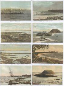
One of 15 sheets with copies of photographs taken of Phillip Island from the Shirley Jones Collection. Photograph A - Cowes and the Pier Photograph B - Cowes Pier Photograph C - Westernport from Rhyll looking towards French Island Photograph D - Back Beach Phillip Island and The Nobbies Photograph E - Back Beach Phillip Island with Cape Woolamai Photograph F - McCaffey's Reef Phillip Island Photograph G - Wreck of The Speke 1905 Photograph H - The Nobbies Phillip IslandCowes + Pier Cowes Pier Phillip Island Westernport from Thyl looking at French Island in middle distance. Back Beach Phillip Island The Nobbies Back Beach Phillip Island with Cape Woolamai Scene McCaffey's Reef Cowes Wreck of The Speke The Nobbies Cowes cowes pier phillip island, westernport, the nobbies phillip island, back beach phillip island, view cape woolamai, mccaffey's reef phillip island, mchaffies reef cowes, wreck of the speke -
 Dutch Australian Heritage Centre Victoria
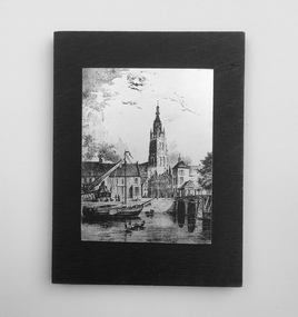
Etching
The Vliet is a canal in the western Netherlands, in the province of South Holland. It starts at the Oude Rijn at Leiden and joins the Delfshavense Schie canal at Delft. Places along its banks include Voorschoten, Leidschendam, Voorburg, The Hague and Rijswijk. The canal was dug in 47 AD under command of Roman general Corbulo, who wished to connect the river Rhine, of which the current Oude Rijn stream in Roman times was the main branch, to the Meuse estuary. It is unclear what the canal's trajectory was beyond the current city of Delft; the Delfshavense Schie canal, which connects Delft to the Nieuwe Maas river was not dug until 1389. In the Middle Ages the Vliet was an important trade link that attracted all kinds of trade, as it flowed through the heart of the County of Holland. Windmills have been constructed alongside the Vliet, including the completely renovated mill 'De salamander' in Leidschendam. The Vliet area was particularly attractive among richer families, who built their mansions along its banks.An historic small town scene etched (or possibly printed) on thin metal and subsequently fastened to a plywood backing. The delicately presented scene is said to show the intersection of Old Church Street and the Vliet Canal bridge in Voorburg, as well as a section of wharf. On the canal are one large and two much smaller vessels. A very tall crane-like construction arises from the wharf to the roof of waterside buildings. The people are soberly dressed in possibly 17th or 18th century costumes.On the reverse has been written: "Oude Kerkstraat Brug over de Vliet Voorburg". (Old Church Street; Bridge over the Vliet canal; Voorburg). However, research proves that the church is actually the Old Church in Delft, a short distance further down the Vliet Canal. -
 Victorian Harness Racing Heritage Collection at Lord's Raceway Bendigo
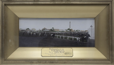
Photograph - Framed photo finish, Diana Wood, Richmond 4/11/1929 - Trotting £1000, 4 November 1929
Richmond ThousandLarge rectangular colour harness race photo finish in gold frame.Richmond 4/11/1929, Trotting £1000, Won by Diana Wood. Owner and trainer G Daniel. Driver owner. Distance 1 1/2 miles. Time 3 mins, 28 sec. Winners Rate 2 min 18 2/3 sec.diana wood, george daniel, richmond thousand, trotting, 1929, g daniel -
 Nhill Aviation Heritage Centre
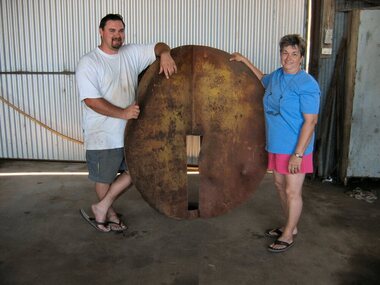
Target, 1941
This was the main target used for bombing and strafing practice during WWII by trainees at the RAAF Air School at Nhill.Original target from the bombing range. Other temporary wooden targets were used but this is the only original target that now exists.This target is made of 10mm steel plate. Two circles approximately 1.5 metres in diameter are slotted and joined at right angles so that when viewed from a distance would always appear as a round ball. Includes four support stays approx. 14 foot long 3" steel pipe with flattened ends.It is marked in several places due to being hit by bombs.target, -
 Bendigo Historical Society Inc.
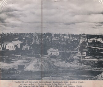
Photograph - MUNGO AND DEVONSHIRE GROUP OF MINES, EAGLEHAWK 1888, 1888
Black and white photo: on bottom of photo ' The Mungo and Devonshire group of mines, Eaglehawk 1888. Looking south. At rear centre. The California Gully State School. Mid distance left to right ' Old St. Mungo' and 'Sadowa' Mines. Foreground left to right, four wheel cab, a windlass, a whip and a whim ( Eastwoods )organization, business, mungo and devonshire group of mines -
 Port Melbourne Historical & Preservation Society
Photograph - Group on heritage tour of the Bayside site, Port Melbourne, Pat Grainger, Dec 1989
Photographed by Pat Grainger, participant in the tour.One of two photographs of heritage tour 31 December 1989: of buildings on Bayside site that are to be demolished for development, conducted by Alison Kelly: Taken from within the emptied Commonwealth Government Engine Works, Ray Paterson of Alfred Street and his baby son Carl. The land-based beacon can be seen in the distance.demolitions, alison kelly, carl paterson, ray paterson -
 Ithacan Historical Society
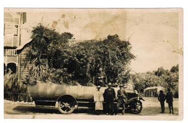
Photograph, Archimandrite Daniel Maravelis, c 1920s
Pictured is Archimandrite, Daniel Maravelis with members of the Greek community in Mildura. He was born in Smyrna and was the Archimandrite of the Greek in Melbourne from 1915 to 1922. He presided over the official opening of the first IPS clubrooms located at Michael's Building, Cnr Elizabeth and Lonsdale Streets Melbourne on Sunday 23rd September 1917. Similar vehicles were used between the years 1915-1925 to travel to picnics.A black and white photograph of a vintage bus parked outside a weatherboard building which is partly hidden with vines. A two storey hotel building is on the LHS of the photograph. A priest is standing in the bus and two men and a lady are standing in front of the vehicle. Two other people are standing on the far RHS. A tent is visible in the middle distance.In Greek: Sigalis and Rita Nicolaidisgreek orthodox community -
 Bendigo Historical Society Inc.
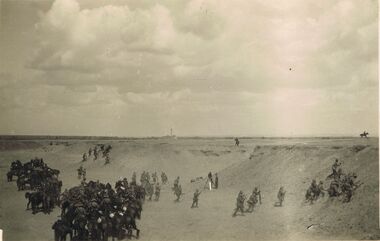
Postcard - ACC LOCK COLLECTION: B&W PHOTO OF SOLDIERS AND HORSES BETWEEN SANDHILLS, POSTCARD, 1914-1918
Postcard, WW1, B&W photo of dismounted soldiers clambouring up sandhills and a group of mounted soldiers standing in foreground. Camera on a tripod with a figure in the centre. Factory chimney in far distance. Handwritten in ink on the back Cinema Film Series LH dismounting & taking up position on crest Zeitoun Feby '16postcard, postcard, ww1, light horse, zeitoun, egypt, cinema film series -
 Myrtleford and District Historical Society
Glass Butter Dish, unknown
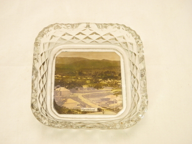
Photograph taken in the early 1930's Photographer unknown ? taken for tourism purposes Photograph shows early buildings of Myrtleford.taken from Reform Hill looking towards Mt BuffaloA small, square glass butter mixer. In the base is an early photograph of Myrtleford in the 1930's looking towards Mt Buffalo taken from Reform Hill In the foreground are the homes of early retailers the Robertson's and Glass Families 1870 and 1880 in the middle of the photo is the School Building No 995 and in the distance is an early building of the Butter FactoryPhotograph in base of glass butter mixer is titled 'Myrtleford'glass dish, myrtleford, homes of early retailers, butter factory, state school 995 streetscape -
 Stawell Historical Society Inc
Photograph, Housing Commission House in Dawson Street -- Photo & Newspaper Clipping
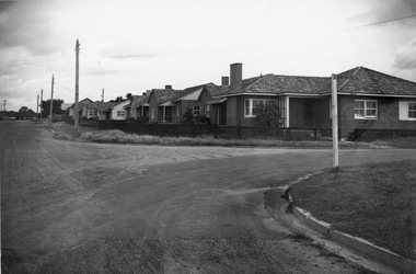
The first Housing Commission homes of brick and tiled roof built after WW2 in Stawell Dawson Street c 1950's. Also in the file a Newspaper clipping from News, Saturday, October 11. 1947. "George Mitchell Square" the first Housing Commission homes built in Stawell. George Mitchell was a member of Borough Council for 40 years and Mayor for 4 years. The housing estate was named in his honor. The architects "Buchannan Laird & Buchanan Geelong.Black and white photograph of a street scene. The photograph shows a line of brick houses along the street with timber fences. Four electric power lines are along the street with 2 in the distance. The street also has curb and guttering. The street to the right has a street post with "George Mitchell St" written on the street sign.stawell -
 Tatura Irrigation & Wartime Camps Museum
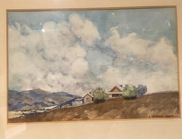
Painting - Painting - Watercolour
Cyril Leyshon White was an official war artist during the Gallipoli Campaign in WWI. He contributed a number of his sketches for “The ANZAC Book". After WWI he became a mentor to the young Sydney Nolan. Lt. White was a member of the 17th Garrison battalion attached to Tatura Camp 1. Landscape. A house with veranda and outbuildings surrounded by a wooden fence. Two bushy green trees partially hide the house with another blue-grey tree at right of picture. The buildings sit on a brown hill with blue-brown hills in the distance. The sky is blue with large s. Gold frame with beige matt behind glass. -
 Mt Dandenong & District Historical Society Inc.
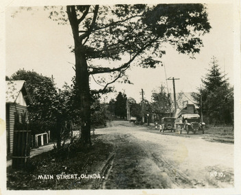
Photograph, Main Street, Olinda, c1930s
Number 10 in commercial seriesSmall photograph, number 10 in Olinda series, showing Main Street Olinda. View is looking NW from Olinda Monbulk Road towards Range Road. Left hand building is old Olinda Post Office. Ice truck is outside shops in distance and a delivery truck with tarp can be seen. c1930solinda, post office, truck -
 Kew Historical Society Inc
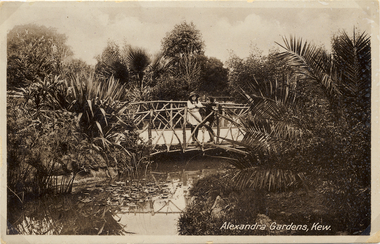
Postcard, Alexandra Gardens, Kew, 1910-1920
Named after Queen Alexandra, these beautiful gardens opened in 1908 and are designed in the formal style typical of the early 1900s.Early postcard showing architectural features and original plantings.The Alexandra Gardens, Cotham Road Kew. The postcard depicts a pedestrian bridge within the Gardens. The bridge, on which are standing two children, has rustic sides. On the evidence of this postcard, planting within the Gardens included a range of exotic specimens including a variegated aloe and water lilies. Native vegetation can be seen in the distance.alexandra gardens - kew (vic), postcards -- kew (vic.) -
 Kew Historical Society Inc
Postcard, Alexandra Gardens, Kew, 1908-1918
Named after Queen Alexandra, these beautiful gardens opened in 1908 and are designed in the formal style typical of the early 1900s.Early postcard showing original architectural features and plantings.The Alexandra Gardens, Cotham Road Kew. The postcard depicts a pedestrian bridge within the Gardens. The bridge, on which are standing two children, has rustic sides. On the evidence of this postcard, planting within the Gardens included a range of exotic specimens including a variegated aloe and water lilies. Native vegetation can be seen in the distance.alexandra gardens - kew (vic), postcards -- kew (vic.) -
 Surrey Hills Historical Society Collection
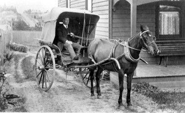
Photograph, Horse and buggy at 44 Guildford Road Surrey Hills, 1913
Jocelyn Hall indicated in notes that the gentleman could possibly be an estate agent. This was confirmed by a grandson of the original owners. (REF: Email 1/8/2020) The original photos is thought to have been a publicity photo for the real estate agency. Carl Theodore Offszanka (1874-1944) was born in Germany. He is listed in electoral rolls at 44 Guildford Road from 1915, occupation furrier, with his wife Ida (nee Schade, 1882-1963), also born in Germany. They were married in Victoria in 1908. In later electoral rolls at the same address are Erna Helena (b 1913; d 1996) and Maria Eliese (b 1910; m Benedict Francis Rieusset in 1936). Both daughters are listed as typists. Also listed is Bernard George (b 1914; d 1987) who in later electoral rolls is described as a process worker. He served in the AIF in the Second World War. Not listed is Carl Bernard b 1909. The Offszanka family lived at 44 Guildford Road from 1913 until post-1980; they came to Surrey Hills from Richmond. Their home was called 'Westfalia' (ref: 1919 electoral roll), presumably after the region in NW Germany. It is not known when Carl and Ida migrated from Germany. This home has had a 2nd storey added to it in late 1990s. According to a family descendant (REF: Email 1/8/20 from grandson) Carl Theodor Offszanka purchased the home in 1913 for £616. He also purchased the adjoining vacant block of land at 42 Guildford Road and ran a large orchard on it before later selling it. This appears to have been between 1920-1930. The family continued to occupy the house until after 1980 when Erna Helena and Bernard George are listed in the electoral rolls. Our property register lists Erna Helena Offszanka as the last member there. She died on 5 May 1996. The Offszanka family occupied this home from its beginning for over 70 years. Such long-term occupancy by one family is unusual.Black and white photo of a ? dark-stained timber Edwardian home at 44 Guildford Road, Surrey Hills. A hooded buggy is located in the rough driveway at the side of the house. A gentleman in a hat and with a moustache is seated in the buggy. A tall building can be seen in the far distance and a street leading up the hill from Canterbury Road.edwardian style, houses, guildford road, horse drawn vehicle, carl theordore offszanka, miss ida schade, mrs ida offszanka, miss edna helena offszanka, miss marie elsie offszanka, mr bernard george offszanka, estate agent, mr carl bernard offszanka, westfalia -
 Lakes Entrance Historical Society
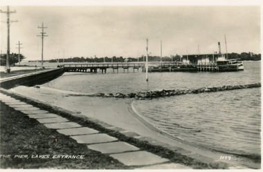
Postcard - Post Office Jetty, 1940c
Black and white small format postcard of the Post Office Jetty, showing a steamer at the end of the jetty, the passenger shelter, rock groyne from shore into lake, bluestone rock retaining wall and flagstone path at edge of lake, three electricity poles and one memorial cypress tree in distance. Lakes Entrance VictoriaThe Pier Lakes Entrancememorials, waterfront, ships and shipping -
 National Vietnam Veterans Museum (NVVM)
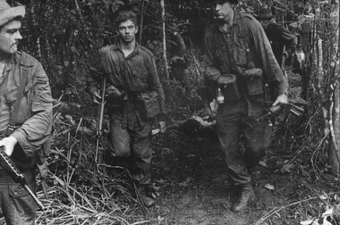
Photograph, Gibbons, Denis, Make Shift Stretcher
Denis Gibbons (1937 – 2011) Trained with the Australian Army, before travelling to Vietnam in January 1966, Denis stayed with the 1st Australian Task Force in Nui Dat working as a photographer. For almost five years Gibbons toured with nine Australian infantry battalions, posting compelling war images from within many combat zones before being flown out in late November 1970 after sustaining injuries. The images held within the National Vietnam Veterans Museum make up the Gibbons Collection. A black and white photograph of Diggers of 11 Platoon, D Company, 6 RAR/NZ (ANZAC) on Operation Lavarack, North East of the Australian Task Force base at Nui Dat, Pte J Korn and L/Cpl L Grygierczyk assist in carrying the makeshift stretcher a considerable distance to the helicopter landing zonephotograph, 11 platoon, d coy, 6 rar/nz, operation lavarack, australian task force, nui dat, pte j korn, l/cpl grycierczyk, gibbons collection catalogue, diggers, 6 rar/nz (anzac), dustoff helicopter, denis gibbons -
 Lakes Entrance Historical Society
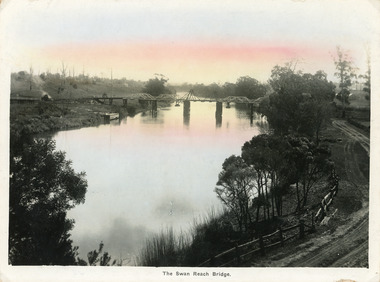
Postcard - Bridges, Bulmer, H D, 1915
Colour tinted large format postcard showing lifting bridge over the Tambo River, at Swan Reach, Victoria. Bridge is closed to allow road traffic through. Rough gravel road to Metung on right. Landing on left near bridge. Vegetation on river bank right. Houses in distance on both sides of river.The Swan Reach Bridgeboats and boating, bridges, waterways -
 Bendigo Historical Society Inc.
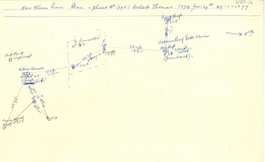
Document - NEW CHUM LINE OF REEF - PLAN OF MINES ALONG PART OF THE NEW CHUM LINE OF REEF
Sketch of some mines along the New Chum Line of Reef. Sheet No (178) Caleb Thomas 1879 Jan 29th. Mines mentioned are: Prince Alfred, Victoria Consols, G Lansell's No 83. Some mines are only a number. Victoria Reef Gold Mines are mentioned. Distances in feet or yards between them.document, gold, new chum line of reef, plan of mines along part of the new chum line of reef, caleb thomas, prince alfred mine, victoria consols, g lansell's no 83, ironbark, victoria reef gold mines -
Frankston RSL Sub Branch
Bugle, 1911
The bugle was most likely used in the First World War for ceremonial and military operational functions. Bugles were an effective means of passing fixed messages and times over the noise and distance of battles and battlefields. Henry Potter & Co was a well known manufacturer of military bugles for the First World War. Copper bugle with brass trim, mouthpiece and brass retaining chain. inscribed "ANZACS" "The Great War, 1914 - 1918"world war one, ww1, brass, musical instrument, bugle, henry potter -
 Warrnambool and District Historical Society Inc.
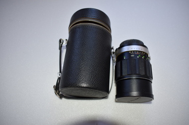
Camera Lens, 1 Soligor Lens. .2 case, C 1960
A manual detachable camera lens is used to focus the subject of which the photograph is to be taken . They have adjustments for distance and clarity while more complex ones can be fine tuned to a much greater degree. Photographs provide a invaluable resource from an historic perspective of past times people and events.This lens has significance as part of the continuum of camera development and use. It was owned by a local Warrnambool person who had a keen interest in photography..1 Black plastic and metal detachable camera lens with metal sections and graduated markings around the cylinder . There is a screw cap on one end where the lens is attached to the camera for use and the other end covering the lens itself has the brand name across the middle of cap. .2 Black leather cylindrical case with strap handle attached with silver metal hiinge and metal zipper towards the top section of the case. The lidded section has the brand name imprinted into the surface of the top..1 Lens made in Japan. Graduated scale from 1.5/5 to 20/50 .2 Soligor camera lens, warrnambool, history of warrnambool, soligor lens -
 Eltham District Historical Society Inc
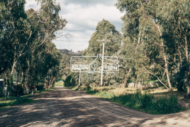
Photograph, Baldwin Avenue from Lilicur Road, Montmorency, c.1972, 1972c
Shire of Eltham road construction and realignment works on Baldwin Avenue, Lilicur Road and Price Avenue, Montmorency, c.1972 Sherbourne Road in distance Ref: EDHS_03875 (1972) and EDHS_04774-4 (2019) from opposite ends showing realignment of road at intersection of Sherbourne and the same Cypress tree35mm colour positive transparency blue Agfacolour Service plastic mountbaldwin avenue, infrastructure, lilicur road, montmorency, road construction, sherbourne road