Showing 4612 items
matching historical maps
-
 Eltham District Historical Society Inc
Book, A voyage from Plymouth to Melbourne in 1839 : the shipboard and early Melbourne diary of Jonathan Binns Were, 1964
J B Were was associated with Henry Dendy. Were Street, Montmorency possibly named for Were. "Were's were importers, exporters, and agents for shipping, land, cattle, sheep and wool. In 1851 they became brokers and buyers of gold, and in 1853 began to deal in shares." - ADB Hardback, no dust jacket; xv, 309 p. : ill., facsim., geneal. tables (folded), maps, ports. ; 20 cm.ISBN 0646002287ship voyage, early settlers, plymouth england, melbourne -
 Eltham District Historical Society Inc
Book, Mary Kent Hughes, Matilda waltzes with the Tommies / by Mary Kent Hughes (T/Major Thornton, R.A.M.C.), 1943
Hardback with dust jacket; 176 p. : ill., maps, ports. ; 22 cm.mary kent hughes, world war ii -
 Eltham District Historical Society Inc
Book, Robert Wuchatsch 1950- et al, Historic views of the City of Whittlesea / Robert Wuchatsch and Gwen Hawke, 1988
Paperback; ix, 119 p. : chiefly ill. (some col.), 1 map, ports. ; 19 x 25 cm.ISBN 0958866333 [written on title page] To Eltham Historical Society, with our compliments and best regards - Whittlesea Historical Society - [signed] Robert Wuchatsch, G. Hawke. 13/12/89.whittlesea shire -
 Eltham District Historical Society Inc
Book, Alan Marshall (1902-1984), These are my people / by Alan Marshall, 1944
Hardback with dust jacket; 202 p. : ill., map ; 19 cm.alan marshall, victoria description and travel, travel, reminiscences, anecdotes, country life -
 Eltham District Historical Society Inc
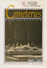
Book, Celestina Sagazio, Cemeteries : our heritage / edited by Celestina Sagazio, 1992
History of Victorian cemeteries; includes a chapter on Aboriginal mission cemeteries; guide to how to use cemeteries for research and family history and how to conserve cemeteries.Paperback; 184 p. : ill., 1 map ; 24 cm.ISBN 0909710856social customs, cemeteries, healesville, victoria, aborigines, st helena, greensborough -
![Book, Garrie Hutchinson, Remember them : a guide to Victoria's wartime heritage / [written & photographed by Garrie Hutchinson], 2009](/media/collectors/4f729f7b97f83e03086018a5/items/59278b33d0cdd112c0eaedec/item-media/5bac35ae21eafa1568280d77/item-fit-380x285.jpg) Eltham District Historical Society Inc
Eltham District Historical Society IncBook, Garrie Hutchinson, Remember them : a guide to Victoria's wartime heritage / [written & photographed by Garrie Hutchinson], 2009
Hardback; xii, 308 p. : col. ill., maps ; 24 cm. ISBN 9781740668408war memorials, monuments, world war 1, world war ii, boer war, victoria -
 Eltham District Historical Society Inc
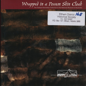
Book, National Museum of Australia, Wrapped in a Possum Skin Cloak by Amanda Jane Reynolds, 2005
Debra Couzens, Vicki Couzens, Lee Darroch and Treahna Hamm revived their communities' craft of cloak-making. Comprises tools, artworks, ornaments and two magnificently worked possum skin cloaks.vii, 64 p. : chiefly col. ill., map, ports. ; 18 cm.ISBN 1876944366aboriginal culture, possum skin cloaks -
 Eltham District Historical Society Inc
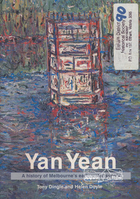
Book, Tony Dingle et al, Yan Yean : a history of Melbourne's early water supply / Tony Dingle and Helen Doyle, Monash University, 2003
Book commissioned by Melbourne Water to mark the 150th anniversary of the commencement of the Yan Yean Reservoir.Paperback; vii, 127 p. : ill. (some col.), maps (some col.), ports. ; 23 cm.[written on flyleaf] To Eltham District Historical Society, best wishes Helen Doyleyan yean reservoir -
 Eltham District Historical Society Inc
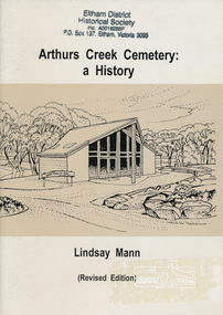
Book, Arthurs Creek Cemetery Trust, Arthurs Creek Cemetery: a History by Lindsay Mann, 2004
Revised Edition.viii, 31 p. : ill., map, ports.ISBN 0646439189arthurs creek, cemetery -
 Eltham District Historical Society Inc
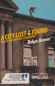
Book, Robyn Annear, A City Lost & Found: Whelan the Wrecker's Melbourne by Robyn Annear, 2005c
Paperback; xii, 303 p. : ill., maps, fascims. ; 24 cm.ISBN 1863953892whelan the wrecker, buildings, melbourne -
 Eltham District Historical Society Inc
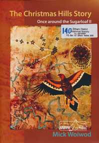
Book, Mick Woiwod, The Christmas Hills story : once around the Sugarloaf II / Mick Woiwod, 2010
Paperback; 275 p. : ill., facsims., maps, ports. ; 30 cm.Inscribed and signed by Author 2010christmas hills, sugraloaf reservoir, aborigines -
 Eltham District Historical Society Inc
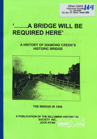
Book, Nillumbik Historical Society, '.......A Bridge Will Be Required Here': A history of Diamond Creek's historic bridge by Jock Ryan, 2005
7 pages, mapsdiamond creek, bridge -
 Eltham District Historical Society Inc
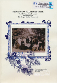
Book, From Laggan to Arthur's Creek : the McDonald family history and connections with the Draper family, Charnwood / written and presented by Ross McDonald, 2010
Paperback; 102 p. : ill. (some col.), maps, ports., facsims., geneal. table ; 30 cm. Two copiesmcdonald family, draper family, charnwood, arthur's creek -
 Eltham District Historical Society Inc
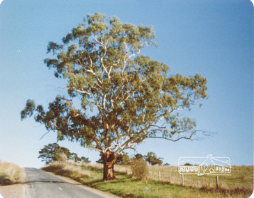
Photograph, Peter Bassett-Smith, White Gum, Main Road Eltham-Yarra Glen, Kangaroo Ground, June 1977, 1977
Colour photograph of a Eucalyptus Viminalis (White Gum or Ribbony Gum or Manna Gum) on Main Road, Eltham-Yarra Glen (Melways Directory Map 23 D1) looking west approximately 1 mile from Kangaroo Ground approx. opposite Andy Avard's gate.eltham yarra glen road, kangaroo ground -
 Eltham District Historical Society Inc
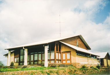
Photograph, Emergency Operations Centre, S.E.S., Kangaroo Ground
In 2017 known as the Kangaroo Ground Operations Centre a facility for hire managed by the Shire of Nillumbik. On 7 February 2009 (Black Saturday) the CFA Incident Control Centre (ICC) was located here. Described in "Worst of Days: Inside the black Saturday firestorm" by Karen Kissane (access via Google books): "..the ICC is part of a mud brick complex built in the 1980s as an emergency operations centre for several agencies, including the State Emergency Service. It is also home to the headquarters of the CFA's Lower Yarra Group. A small office with a whiteboard would be the incident controller's office throughout the office, but a larger central room, with data projectors, "smart boards" and maps would house the rest of the team.."Statement of Significance From the Victorian Heritage Database (2010) What is significant? The 1988 emergency operations centre and the surrounding site to the title boundaries. How is it significant? The emergency operations centre is architecturally, aesthetically, socially and historically significant to the Shire of Nillumbik. Why is it significant? The emergency operations centre is architecturally and historically significant as a good and rare example of a large public building constructed in a 1980s version of the 'Eltham style', and as a rare attempt to adapt the 'Eltham-style' aesthetic to meet the changing demands of the Shire in the 1980s (Criteria B, D & E). The emergency operations centre is architecturally and aesthetically significant because it is constructed of mud brick and features: a central entry with a tile mural (Criterion E). The emergency operations centre is socially significant because it is a focal point for the community and has played an important role in protecting the community since 1988 (Criterion G).Two colour photographs of mud brick Emergency Operations Centre building, Kangaroo Groundbuildings, mud brick, emergency centre, kangaroo ground -
 Eltham District Historical Society Inc
Folder, Thomas Bibbs
Some comments/observations of the district based on a photo map of the County of Evelyn which was published 1866, compiled 1855 by Thomas Bibbs. A4 photocopy of notesthomas bibbs, tommy's hut, parish of nillumbik, michael callanan, map, kinglake, kangaroo ground, arthurs creek, carden, county of evelyn, haley's preemptive right, isabella donaldson, j. mason, james donaldson -
 Warrnambool and District Historical Society Inc.
Map - An Angler's map of the Hopkins River Estuary, Angler's map Hopkins River, 1980s
This is a map of the Hopkins River Estuary prepared by Dr John Sherwood for the benefit of anglers. The information on the sheet includes the location of sand banks, the water depths, boat ramp facilities and public access facilities. Some of the information has been gathered from aerial photographs. The map has been produced by the Warrnambool Institute of Advanced Education which was developed in the late 1960s from the tertiary section of the Warrnambool Technical College and with all its departments established by 1984 at the Sherwood Campus five kilometres from Warrnambool on the Princes Highway. Today the site is occupied by Deakin University, Warrnambool campus. The Warrnambool Anglers’ Club has its headquarters on the banks of the Hopkins River near the mouth of the river and the Lyndoch Aged Care facility.This map is of interest as a specialist one, providing fishermen with detailed information on all aspects of the Hopkins river estuary. Fishing has been both a profession and a popular recreational pursuit for Warrnambool residents since the early days of the city’s settlement. The Hopkins River Estuary has been a focal point for fishermen throughout Warrnambool’s history. This is a sheet of paper folded three times to produce a folded map. The front cover has a black and white photograph of two fishermen with a large fish. The map of the Hopkins River Estuary is in yellow, blue and black and covers the side of one sheet and three quarters of the other side. There is an advertisement for the Hopkins River Boathouse with a black and white sketch of the boathouse and notes on the map written by Dr John Sherwood. There are several diagrams showing the water depths. The map has some silverfish damage and some tearing at the folds. warrnambool anglers’ club, history of warrnambool, hopkins river, hopkins river estuary, john sherwood -
 Warrnambool and District Historical Society Inc.
Booklet, Victorian Almanacs, 1860s
These Victorian Almanacs were published from 1859 to 1916. They contained information of interest to all Victorians, especially historians, businessmen, farmers and gardeners and must have sold many copies in Warrnambool, particularly before the local Warrnambool Standard Almanacs began publication in 1875. These booklets are of interest as examples of 19th century almanacs published in Victoria. They are also somewhat similar to the Almanacs published annually by the Warrnambool Standard newspaper from 1875 to 1930. The 1869 Almanac is of particular interest as it has on the front cover the printed name of James Hider, stationer and bookseller of Warrnambool. James Hider had been a carpenter, a land agent and a rate collector before opening a shop in Timor Street, selling books and stationery and operating a Circulating Library. In 1865 Hider set up as a photographer and was still operating this business in 1878. He was active in community organizations, including the Mechanics Institute, the Fire Brigade, the National School, the Musical Group and the Benevolent Society. He was also a Councillor and a Mayor in the 1860s. It is interesting to note that his name does not appear to have been been added to the 1869 Almanac cover but is part of the original printing. These are two soft cover booklets of 60 pages each. The back covers of both are missing and the 1868 booklet has some back pages missing. The 1868 Almanac has a black and white cover with ornamental scrolls and the 1869 booklet has a red, green black and cream cover with an ornamental border and images of flora and fauna. The 1869 Almanac cover has a Coat of Arms with Advance Australia printed at the bottom of it. The 1869 Almanac also has a map of Victoria as an insert. Both almanacs contain an historical calendar, Victorian Parliamentary information, data on Victorian cities, postal regulations, farmers’ and gardeners’ guides etc. Both contain advertisements relevant to Melbourne. Both have been bound with string. victorian almanacs, annual journals, james hider, bookseller and stationer,, warrnambool. -
 Warrnambool and District Historical Society Inc.
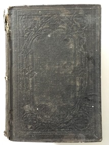
Book, Barnes Notes on the Four Gospels, 1857
This is a book given in 1860 to Miss M. Davidson by L.H.R Miss M. Davidson would most likely be Margaret Milne Davidson (1839-1928) who was born in Kirremuir, Scotland and was the daughter of James and Isabella Davidson of Woodend near Cassadys Bridge on the outskirts of Warrnambool. She never married. The identity of ‘L. H. R.’ is unknown. This book is significant firstly because of its antiquarian interest (an 1857 publication) and secondly because of its connection to Margaret Davidson. Her father and uncle and their families were pioneer settlers in Warrnambool and thus of great importance in our history. This is a hard cover book of 53 pages. The cover is brown with an ornamental pattern impressed into the front cover and gold lettering on the spine. The book has a Preface, an Introduction, 21 chapters of text by Rev. Albert Barnes and an Index. It has a colour fold-up map of Palestine. There is a stamp of the Warrnambool & District Historical Society on the first page and an inscription in black ink. The cover is partly broken away and torn. ‘Miss M. Davidson from L.H.R. Warrnambool 4 May 1860’. margaret davidson, history of warrnambool -
 Warrnambool and District Historical Society Inc.
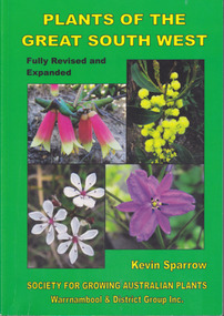
Book, Star Printing Terang Victoria. 978-0-9751360-1-0, Plants of the Great South West 2013 Second Edition, 2013
Second edition (revised a& expanded edition) First edition 2004. Guide to the indigenous plants of South West Victoria. South West Victoria: Nelson – Port Campbell. Zone A.B.C & D. Local maps BioregionsCard cover green) gloss white paper. End papers. Map 1&2. 6 pages credits, title, table of contents, forward, acknowledgements, disclaimer, websites. 348 pages. Colour maps & photographs. References & reading. Index plantsof western victoria, kevin sparrow, warrnambool -
 Warrnambool and District Historical Society Inc.
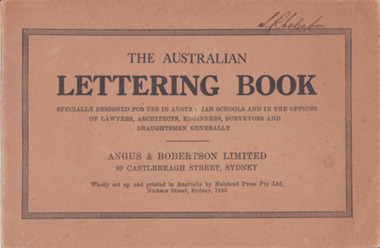
Booklet - Lettering Book, Halstead Press Pty Ltd, The Australian Lettering Book, 1945
Author Herbert Newell. Alphabets of varied fonts, headings, flourishes, plans, numerals, sketch maps, scrolls, shading, common errors, compass points. Especially designed for use in Australian Schools, offices of Lawyers, Architects, Surveyors, Engineers, Engravers, and Draughtsmen. Table of contentsThe author is a teacher of show card and ticket writing at Sydney Technical College. Book used by many students and offices. Note by the publishers provides standards for the correct form of the characters. Light brown light card cover with black ink font and border patterns. 32 Cream pages with black ink. Two staples. Hand written name on top of outline black border S. R Coleston. Price 3/9warrnambool, lettering book, angus & robertson limited, s.r. coleston, herbert newell -
 Warrnambool and District Historical Society Inc.
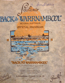
Programme - Back to Warrnambool 1930 official souvenir program, January, 1930
This booklet contains the Program for the Back to Warrnambool Celebrations for 1930. It contains a brief history of the town and photos of current council Office bearers and local scenic spots. There is also a map of the town and a large number of advertisements for local businesses. Back to Warrnambool celebrations were an important event on the social calendar and were run over a number of years in the town. This program is one glimpse into the city and its people in 1930. Some of the events held over the week included processions, sports Carnivals, concerts, card playing, Church services and local tours. Many of the advertisements are for businesses of long standing and importance to the prosperity of the town. Twenty page Booklet with light card, grey, mottled cover. Text in brown and blue. Picture of Warrnambool main beach in centre. Price 2/- in bottom right corner. Back cover has full page advertisement for Bruce and McClure. Text and illustrations are brown. M Armstrong is written in blue biro on top right corner. Song “Back to Warrnambool,” written and composed by Reg A.A. Stoneham,” is printed below picture on front cover. Published by A.A. Stoneham, 241 Carlisle St, Balaclava.younger pty ltd, warrnambool, back to warrnambool, 1930, souvenir program, warrnambool cordials, morse pty, swinton, warrnambool cheese and butter factory, batros shoes, tattersalls hotel, bruce and mcclure, warrnambool woollen mill, reg a. a. stoneham -
 Warrnambool and District Historical Society Inc.
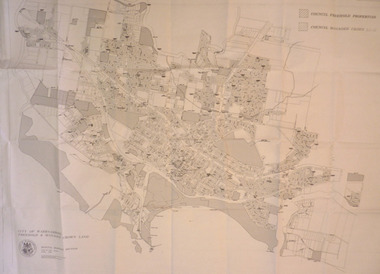
Map - City of Warrnambool Freehold and Managed Crown Land, City of Warrnambool Council, 14th April 1994
This map was drawn up by the City of Warrnambool Council staff to provide information on the land in Warrnambool that was owned or managed by the Council.This map is of considerable importance as it gives information in map form of the Warrnambool land that is owned (freehold) by the City of Warrnambool and the land that is managed Crown land. This is of interest to researchers and those seeking information on specific areas of land in Warrnambool.This map has digital mapping. The map has a white background with black and white mapping details of Warrnambool. It has the City of Warrnambool seal. Scale of map: 1:7500warrnambool city council, warrnambool -
 Warrnambool and District Historical Society Inc.
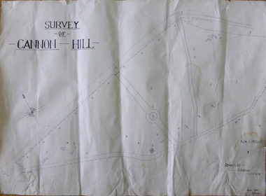
Work on paper - Project, Cannon Hill 1939, 1939
A map thought to be a school project depicting the layout of Cannon Hill, a popular lookout in Warrnambool.A locally drawn map indicative of school work from the 1930’s.A map thought to be a school project depicting the layout of Cannon Hill, a popular lookout in Warrnambool.Drawn by R Graham. Checked 13/02/1939 T E Wingrovecannon hill, school project 1939 -
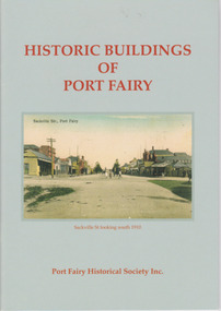 Warrnambool and District Historical Society Inc.
Booklet, Port Fairy Historical Society, Historic Buildings of Port Fairy, 2012
Port Fairy, a small town in Western Victoria established in 1836, has an exceptional collection of public buildings and dwellings dating from the 1840s. This booklet gives short descriptions of 58 of these historic buildings, many with accompanying photographs. These include many buildings in Gipps and Sackville Streets, the Powder Magazine, some hotels, the Drill Hall, Dublin House, the Port Fairy Cemetery and several schools and churches. This booklet is useful for those seeking quick information on the historic buildings in Port Fairy and for those wanting to undertake a walk around the town’s historic spots. TryBooking will show you the full breakdown on the Booking Payment Report and the Event Revenue Itemised Report so you can clearly see the ticket sales, credit card processing fee and the funds that are yours. Front cover: ‘Historic Buildings of Port Fairy, Port Fairy Historical Society Inc.’ Photograph on front cover: ‘Sackville Str. Port Fairy’, ‘Sackville St. looking south 1910’ Back cover map: ‘Port Fairy Historic Buildings’ warrnambool, port fairy, western victoria, historic buildings -
 Warrnambool and District Historical Society Inc.
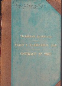
Document - Victorian Railways. Koroit & Warrnambool Line. Contract No. 2937, Circa 1888
The Victorian Railways began in 1854 and in the first 14 years up to 1868 had managed to complete about 250 miles of track. The next 60 years saw the system expand to nearly 3000 miles. By 1931 every town with a population over 500 had its own railway station. Early Victorian railway maps indicate that the extension from Colac to Warrnambool and then onwards to Koroit, occurred in the period of the 1880’s when the act known as the Octopus act saw a rapid expansion of lines. At the time there was much debate over where the expansion of the lines should take place, with one of the prime considerations for Warrnambool was the impact it would have on its port.The building of the railway to Warrnambool and onward to Koroit was a significant event for the town. Green cloth cover with tan suede corner points and spine. Title printed in gold on front cover. Title printed in gold on red on spine. 92 pages. The contract is printed and includes handwritten entries with specifications.Handwritten on front cover and inside front cover ” Copy for Engr in Chief” .On Page 2 transferred to Allan Reid * 24/1/88 Co Briscoe & Co Little Collins Street, Melbourne.warrnambool, railways, warrnambool to koroit railway, victorian railways contract no 2937 -
 Eltham District Historical Society Inc
Negative - Photograph, Popular Picnicing at Hurstbridge, c.1925
Picnickers enjoying a Sunday outing near the Wattle Valley Estate at Hurstbridge. Copied from brochure "Wattle Valley Estate". It is believed the picture is taken at the northwest corner of the intersection of Wattletree Road and Hurstbridge-Arthurs Creek Road looking southeast towards the township (most likely where the house is located on the property of what is today No. 2 Wattletree Road)- https://goo.gl/maps/VDorwCe1rJJUapjE6 According to a comment by Jean Verso (via @nillumbikcouncil FB page 3 Jan 2020) - "This view is from Wattle Tree Road with Haleys Gully Road to the right and across the creek to William Gray's nursery at Allwood. The building to the far left looks like Dorset House. The building on the left in the middle distance is still there today and has been used for storage and as a stable/tack room for a number of years." The Wattle Valley Estate was first advertised in August 1925 as weekend building allotments by the Greater Melbourne Land and Development Company. Advertised from £28.10.0 or £60 per block. In August 1926, 30 picked allotments of 60x150 feet were put up for auction Saturday August 14, 1926 with frontages to Valley View Road and Fawkner Crescent advertised in the “Heart of the Glorious Wattle Country” and “Within 15 Minutes of the Newly Electrified Railway Station”. The Advertiser on August 13, 1926 in an article promoting the auction stated “the estate is regarded as one of the best in the district, and will be sold practically without reserve.” It is noted that an advertisement running in The Argus February 22, 1951 offered the remaining 16 blocks for sale at £12.10.0 or £200 the lot. By March 7, the remaining blocks were advertised at £17.10.0 The Wattle Valley Estate took over 20 years to sell and then people could not build on them Cross Ref EDHS_02665 Rose Series Postcard P. 4341, "View at Hurstbridge, Vic." Also, other images from sales brochure SEPP_1055 / 1056This photo forms part of a collection of photographs gathered by the Shire of Eltham for their centenary project book,"Pioneers and Painters: 100 years of the Shire of Eltham" by Alan Marshall (1971). The collection of over 500 images is held in partnership between Eltham District Historical Society and Yarra Plenty Regional Library (Eltham Library) and is now formally known as the 'The Shire of Eltham Pioneers Photograph Collection.' It is significant in being the first community sourced collection representing the places and people of the Shire's first one hundred years.Digital image 4 x 5 inch B&W Neg1925, dorset house, fawkner crescent, haleys gully road, hurstbridge, hurstbridge-arthurs creek road, picnic, postcards, shire of eltham pioneers photograph collection, valley view road, wattle valley estate, wattletree road, exhibition yprl 2019-12 -
 Eltham District Historical Society Inc
Negative - Photograph, Main Road, Eltham, looking south from Bridge Street, 1906-1907
Looking south along Main Road from the south side of the intersection of Bridge Street with Main Road. Anne Hunniford's Post Office and Burgoyne's store on left. Miss Harriet (Minnie) Williams's Cash Drapery Mart (est. 1902 and enlarged in 1906), also known as Eltham House on the right. Harriet (Minnie) Williams was born London, 1857, the daughter of George John Williams (1812-1895) and Jane Mansfield (1812-1895). In September 1885 she was operating Williams’s Drapery Establishment in premises on Main Road owned by R. Wallis who advertised them to let in September 1885. In 1902 she opened Williams’s Cash Drapery Mart at the southwest corner of Bridge Street and Main Road (opposite the Post Office), owned by W.J. Taylor. In 1906 she bought the premises and one quarter acre of land and expanded the business with a re-opening in April 1906. Harriet was also well-known and esteemed as an active worker in Methodist circles and also Superintendent of the Sunday School. Harriet fell ill in August 1907 and died 15 August. She is buried in Eltham Cemetery with her good friend Ada Ford. Note also the gas street lamp on right. Watson's Hotel on corner of Pitt Street visible in distance. The CBA bank building is hidden behind trees, the chimney and part roof visible. The photo was possibly taken by John Henry Clark of Clark Bros Photographers who operated from 25 Thompson Street, Windsor near Prahan 1894-1914. Evelyn Observer and Bourke East Record (Vic. : 1902 - 1917), Friday 30 March 1906, page 5 ________________________________________ ELTHAM. (FROM OUR OWN CORRESPONDENT.) For over three years Miss Williams has carried on a drapery business in very small and inconvenient premises opposite the Eltham post-office. Recently she bought the building and a quarter-acre of land from Mr. W. J. Taylor. Thus having a free hand, she at once matured plans to enlarge and improve the premises to make them suitable for her growing business. The result being that she consulted Mr Roach, contractor, of Heidelberg, put the matter in his hands, and now he has completed in a very satisfactory manner and up-to-date style extensive improvements. A large addition, of very neat and attractive design, with three large windows, has been built right along the front of the old building, and the counters and inside fittings are very neat and convenient, harmonizing well with the attractive outside appearance. Miss Williams has now got in a large now stock of goods, and is making extensive arrangements for a “reopening week," commencing 2nd April, during which time she will make 10 per cent reduction on all cash purchases in the form of gifts of that value. Miss Williams has gone to considerable expense and liability both, in the enlargement and improvement of the premises and in purchasing additional stock. We therefore trust that the public will stand by her by heartily and en masse patronizing her re-opening effort to show their appreciation of pluck in this advance movement. Google Street View Feb 2017: https://www.google.com.au/maps/@-37.7191341,145.1462046,3a,50.5y,191.91h,88.27t/data=!3m6!1e1!3m4!1sARwwqEQfMSfH9oTWWapPgQ!2e0!7i13312!8i6656 This photo forms part of a collection of photographs gathered by the Shire of Eltham for their centenary project book,"Pioneers and Painters: 100 years of the Shire of Eltham" by Alan Marshall (1971). The collection of over 500 images is held in partnership between Eltham District Historical Society and Yarra Plenty Regional Library (Eltham Library) and is now formally known as the 'The Shire of Eltham Pioneers Photograph Collection.' It is significant in being the first community sourced collection representing the places and people of the Shire's first one hundred years.Digital image (x2) 4 x 5 inch B&W Neg B&W Print 16 x 25 cmsepp, shire of eltham pioneers photograph collection, eltham, main road, anne jane hunniford, burgoyne store, christopher watson, commercial bank of australia, drapery store, eltham house, gas lamp, harriet (minnie) williams, post office, street lamp, watson's hotel, williams's cash drapery mart, clark bros. photo -
 Eltham District Historical Society Inc
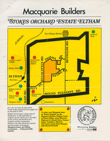
Document, Stokes Orchard Estate Eltham; Macquarie Builders, 1979c
Sales brochure including photocopy map of Stokes Place lots and Sales Manager's business card (John J. Herold). Stage 1 implemented c.1976 and Stage 2 c.1979. As shown on the plan, the lots along Diosma Road did not eventuate due to the lack of sewer system. These lots and streets were divided up into 5 acre blocks, which were not able to be subdivided till the 1990s when the sewer was run up Diosma Road. Stokes Place was part of the Stokes Orchard Estate which was developed from the break-up of the the orchard owned by Frank Stokes who lived on the northeast corner of Nyora Road and Eucalyptus Road. His daughter Beryl advised that the Shire had levied a rate assessment on individual parcels of land within the orchard which became unaffordable resulting in its sub-division and sell off. The Stokes Orchard Estate was developed by Macquarie Builders in two stages starting with stage 1 in 1976. Stokes Place was part of Stage 2 in 1979. The Estate was bounded between Nyora Road, Eucalyptus Road, Diosma Road and Stokes Place. The original orchard only just reached the left most portions of Stokes Place and did not go fully up to Diosma, rather to just beyond the extant of Stokes Place. Stokes Place was known within the family as "The Oats" as that is where they grew oats. Frank Stokes moved to Eltham c.1945 after visiting Harold Bird to view his orchard, located diagonally opposite Stokes Orchard from the intersection of Eucalyptus Road, Pitt Street and Nyora Road. It was on Harold Bird's recommendation that Frank purchased the land.The Stokes Orchard Estate collection is typical of housing developments of the late 1970s and 1980s. It was one of the earliest estates in Eltham following the nearby Woodridge Estate development.A4 colour brochure double sided, A4 photocopy and business cardAs notedstokes place, eltham, stokes orchard, stokes orchard estate, streets, houses, peter and carla vermey -
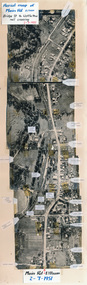 Eltham District Historical Society Inc
Photograph, Aerial map of Main Road, Eltham from Bridge Street to Wattletree Road, 2 July 1951, 1951
Constructed from five aerial images stitched together and adhered to a coreflute board (approx 100 x 30 cm) with inscriptions of street names and places written and/or stuck onto surface.eltham, main road, aerial photographs, streets, buildings, houses