Showing 16995 items
matching plenty-river
-
 Wangaratta Art Gallery
Painting, Angelo Quabba, Gums By The River, 1992
Rural City of Wangaratta Collection. Gift of the artist 1992.A landscape scene of a river winding through gums painted with oils using a colour palette of green, brown, grey, blue, orange, and purple.Obverse: A. Quabba 1992/ (bottom right corner)wangaratta art gallery, angelo quabba, landscape, painting -
 Ballarat Heritage Services
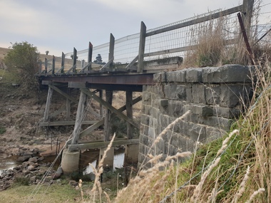
Painting, Clare Gervasoni, Old Bridge over the Woady Yallock River, 26/03/2023
Colour photographs of an old timber topped bridge crossing the Woady Yalloak River on Golden Lake Road. The bridge has bluestone foundations. bridge, woady yallock river, golden lake road, bluestone -
 South Gippsland Shire Council
Photograph, Mounted, Tidal River Wilson's Promontory, 2003
Aerial colour photograph titled "Tidal River Wilson's Promontory. Laminated and block mounted on foamcore board. Text panel lower edge. -
 University of Melbourne, Burnley Campus Archives
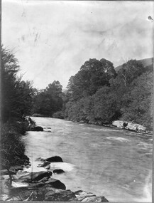
Photograph - Black and white print, River View, Unknown
Black and white photograph. View of a river. Possibly an excursion. Photographs B91.409 to B91.417 appear to have come from the same photograph album.river, excursion, rural view -
 Greensborough Historical Society
Document - Booklet and CD-ROM, Greg Neumann, The Starling and Stewart families at Janefield, Yan Yean, Greensborough, Diamond Creek, Plenty and Yarrambat, from the late 1850s onward, compiled by Greg Neumann, 2021
Story of the Starling and Stewart families over several generations as farmers in the Plenty-Yarrambat area, compiled by Greg Neumann2021 updated version: on CD Rom. 2013 version: 19 p., black and white and colour photographs and maps, stapled top left corner.starling family, stewart family, plenty river, plenty, janefield mill, janefield mill on the plenty river, yarrambat -
 Greensborough Historical Society
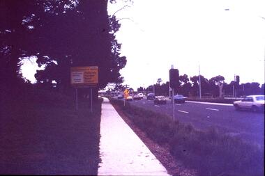
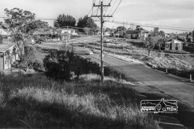
Slide - Photograph, John Ramsdale, Plenty Road near Parade College: Slide 29, 1990s
Photograph shows a 3-lane road with "Federally funded" sign This is Plenty Road Bundoora, near Parade college.Part of the John Ramsdale collection of slides and audio visual material.Colour photograph scanned from slide.No caption. Printed maker's mark on slide "Kodak Kodachrome Slide"plenty road bundoora, parade college -
 Greensborough Historical Society
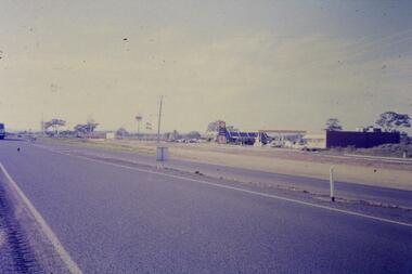
Slide - Photograph, John Ramsdale, Plenty Road and urban creep: Slide 28, 1990s
Photograph shows Plenty Road Mill Park with Shell petrol station and Macdonalds, showing the urban expansion in this area.Part of the John Ramsdale collection of slides and audio visual material.Colour photograph scanned from slide.No maker's marks. No caption on slide.plenty road mill park, urbanisation -
 Greensborough Historical Society
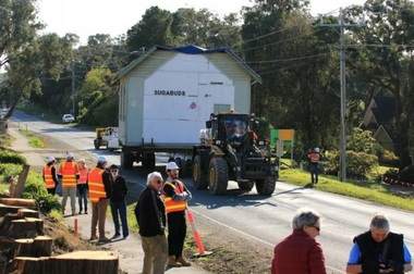
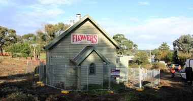
Photograph - Digital Image, Former Uniting Church, Plenty : relocation, 2018_
The former Uniting Church being relocated due to roadworks in Plenty. The building was most recently used as a florist - Sugabuds.Digital copy of colour photographplenty- places, sugabuds florist, uniting church -
 Greensborough Historical Society
Photograph - Digital Image, Former Uniting Church, Plenty : relocation, 2018_
The former Uniting Church being relocated due to roadworks in Plenty. The building was most recently used as a florist - Sugabuds.Digital copy of 3 colour photographsplenty- places, sugabuds florist, uniting church -
 Orbost & District Historical Society
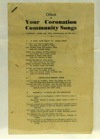
booklet, Your Coronation Community Songs, 1953
This booklet was printed by the Snowy River Mail newspaper to be used at a community event celebrating the Coronation of Her Majesty Queen Elizabeth II in the Abbey Church of St. Peter, Westminster, on Tuesday, the second day of June, 1953. The coronation of Queen Elizabeth 11 was a significant event in 1953. This booklet is representative of a community event.A booklet containing word of songs for a community celebration of the coronation of Queen Elizabeth 11. It is titled "Your Coronation Community Songs". For Tuesday June 2 1953 at 7.45pm.coronation booklet-songs souvenir -
 Eltham District Historical Society Inc
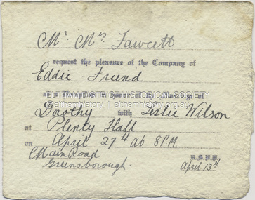
Document - Invitation, Invitation to the wedding reception of Dorothy Fawcett and Leslie Wilson, Plenty Hall, Main Street, Greensborough, April 27, 1940
Invition to Richard Edward Fielding and a friend to attend the wedding reception for Dorothy Fawcett and Leslie Wislon at Plenty Hall, Greensborough on April 27, 1940 Mr - Mrs Fawcett request the pleasure of the Company of Eddie - Friend at a Reception in honour of the Marriage of Dorothy with Leslie Wilson at Plenty Hall on April 27th at 8 P.M Main Road, Greensborough. R.S.V.P. April 13thdorothy may fawcett, greensborough, leslie anzac wilson, main street, plenty hall, reception, richard edward fielding, tom fielding collection, wedding invitation -
 Eltham District Historical Society Inc
Photograph, Looking south along Para Road at intersection of Alma Street and Lees Road, Lower Plenty, c.July 1967, 1967
Old community hall (long wall with row of windows) and Lower Plenty Kindergarten visible at corner of Glenauburn and Para Roads. Packaged in "Filmpro King Size prints Definitely Better EST. 1918" envelope. Pencil notes: 36 shots $2.87 Eltham Shire J. McD and 19/7/67. Alma Street and Kett Street Lower Plenty c.July 1967.Black and white photographalma street, glenauburn road, carisbrook crescent, lees road, lower plenty, lower plenty kindergarten, para road, houses, streets -
 Greensborough Historical Society
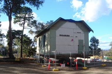
Photograph - Digital Image, Marilyn Smith, Former Uniting Church, Plenty, 2018_
The former Uniting Church being prepared for removal due to roadworks in Plenty. The building was most recently used as a florist - Sugabuds.Digital copy of colour photographplenty- places, sugabuds florist, uniting church -
 Greensborough Historical Society
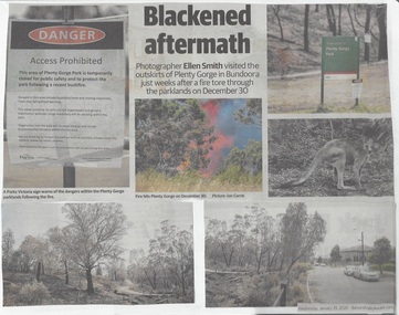
Newspaper Clipping, Diamond Valley Leader et al, Scorched Earth: attention turns to recovery plan after devastating Plenty Gorge fire, 29/01/2020
An eerie, blackened landscape remains after a bushfire ripped through more than 40 ha of the Plenty Gorge parklands.News article 2 pages, black text and colour images.plenty gorge park, bushfire -
 Greensborough Historical Society
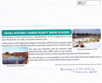
Article - Article, Newsletter, Local History: Yarra Plenty Swim School, 03/2021
Article from Brooksy's Briefing March 2021 about the Yarra Plenty Swim School, with a brief history of he pool.Clipping from Brooksy's Briefing March 2021, text and colour illus.watsonia high school, swimming pools greensborough, yarra swim school -
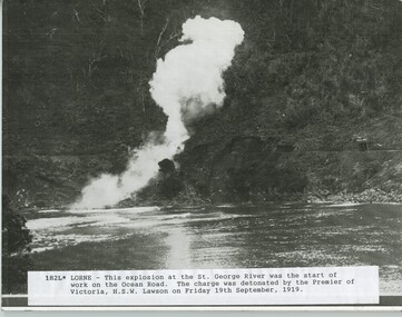 Lorne Historical Society
Photograph, Explosion at the George River
This explosion at the George River was the start of work on the Great Ocean Road. The charge was detonated by the Premier of Victoria, HSW Lawson on Friday, 17 September, 1919exlosion, st george river, h.s.w. lawsom, premier, great ocean road -
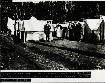 Lorne Historical Society
Photograph, The Returned Soldiers Camp at St. George River
Six workmen and cook? near tents at St George River Returned Soldiers' Camp. Note timber tramway on left-hand side of photographreturned-soldiers-camp; st.-george-river. timber-tramway-track -
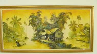 National Vietnam Veterans Museum (NVVM)
Painting, MINH _ Vietnam Artist, Mekong River Delta Village, c. 1970
Painting colour in Gold/Brown timber frame depicting Mekong River Delta Village..Acrylic / canvas Village life -Houses, Boats and People.Min H Vietnam.mekong river delta villiage, framed painting -
 Whitehorse Historical Society Inc.
Map, Yarra River, n.d
Copy of fold-out map 'Loddon 25' included in 'Lilydale', by Grace Aveling. Based on T.H. Nutt's original survey of the Yarra River, 1839.aveling, grace, nutt, t.h., yarra river -
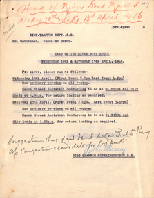 Melbourne Tram Museum
Document - Memorandum, Melbourne & Metropolitan Tramways Board (MMTB), Head of the River Boat Races, Apr. 1946
Memos from Dist Traffic Supt SS about the Head of the River Boat Races held Wednesday 10th and Saturday 13th April, 1946.trams, tramways, letters, instructions, events, hanna st depot, malvern depot, glenhuntly tram depot, hawthorn depot, camberwell depot -
 Lakes Entrance Regional Historical Society (operating as Lakes Entrance History Centre & Museum)
Photograph, Lakes Post Newspaper, 1999
Photo and article appeared in the Lakes Post Newspaper 28 July 1999|Barge was built by Wayne Smith for the firm East Gippsland Bridges.|Also two other photographs similarColour photograph of the launching of a new work barge in the Tambo River, Victoria.boats and boating, topography, waterways, celebrations -
Lakes Entrance Regional Historical Society (operating as Lakes Entrance History Centre & Museum)
Postcard, 1/02/2024 12:00:00 AM
Also two colour photographs of same cliff taken 1999 August donated by Marion Holding 04477.1 and 04477.2 10 x 15 cmBlack and white photograph of the cliffs on the Tambo River at Tambo Upper Victoriavisit of Monkhouse family 6th to 24th February 1924 on backwaterways -
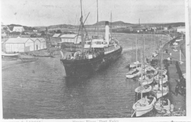 Port Fairy Historical Society Museum and Archives
Photograph, 1905
B&W Photograph Iron Steamship SS Casino in the Moyne Rivership, boat, sea, river, iron steamship ss casino -
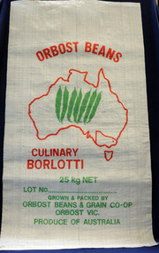 Orbost & District Historical Society
seed bag, mid 20th century
Orbost Beans & Grains Co-Op was an extension of Snowy River Sweet Corn Co-Op which also sold fresh produce such as corn, squash, zucchini and cucumbers. This bag is unused and would have been packed with borlotti beans.Snowy River Seeds started life as a farmers' co-operative (Snowy River Co-op) in 1967. This item is significant because it was specially made for the seed bean industry which was a major industry in the Orbost district for over a century. A white woven synthetic bag used for packing borlotti beans. Inside a red outline of Australia are seven green beans. Victoria is outlined and Orbost is indicated with a red d t. Print is red and green. On front : Grown & Packed By Orbost Beans & Grain Co-Op 25 kg Orbost Victoria Produce of Australia seed-bag snowy-river-co-op agriculture farming orbost-beans -
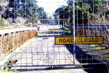 Greensborough Historical Society
Slide - Photograph, John Ramsdale, Old bridge at Lower Plenty under reconstruction: Slide 83, 1990s
Photograph shows a road construction area with "Road Closed" sign and temporary fencing. This is the old bridge at Lower Plenty under reconstruction.Part of the John Ramsdale collection of slides and audio visual material.Colour photograph scanned from slide.No maker's marks. No caption on slide.old lower plenty bridge, lower plenty bridge -
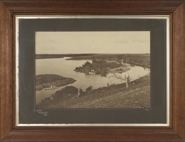 Warrnambool and District Historical Society Inc.
Photograph - Framed Photograph of the Islands in the Hopkins River, Jordan Studios, Warrnambool, 1911
This photograph shows the islands in the Hopkins River in 1911. This section of the river is in the Allansford area, near Jubilee Park (Hopkins River Caravan Park). It was, and still is, a picnic and fishing spot. On one of the islands is an unmarked grave which may be that of Jemima Christine Allan, the first wife of one of the first European settlers in the Allansford area, William Allan. She died in 1842. The photograph was taken by Jordan Studios so the photographer may be either Joseph Jordan, one of the best-known Warrnambool photographers of the past, or his son Arthur, also a well-credentialled photographer.This photograph is considerable historical importance, showing a section of the Hopkins River in the Warrnambool region in 1911.This is a black and white photograph in a wooden frame with a patterned edging. The photograph is inset with a gilt metal edging and enclosed in glass. The backing is wooden with a wire cord for hanging. The photograph shows the river with islands covered in vegetation. On the river are two boats, one wuih four occupants standing up in the boat and the other with two occupants. In the ccntre of the photograph is a tree stump and a dead tree.The Islands Hopkins River Warrnambool 1911 Jordan Photohopkins river, jemima allan, jordan studios -
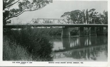 Orbost & District Historical Society
black and white photograph, Rose Stereograph Company, first half 20th century
A new bridge over the Snowy River at Orbost was opened for traffic on June 20th 1922. It was a new timber and steel girder structure, a joint Country Roads Board — Victorian Railways venture and was built and completed at a cost of £41,000 (the steel girders came from the Flinders Street viaduct reconstruction). Subsequently it was decided not to take the railway across the river, and the bridge was only ever used by road traffic. Postcards form a vital part of social and historical records for researchers. This postcard is a pictorial record of an earlier bridge across the Snowy River at Orbost.A black / white postcard photograph of a bridge over the Snowy River at Orbost.0n front - The Rose Series P1200 copyright Bridge Over Snowy River Orbost Vic.snowy-river-bridge -
 Marysville & District Historical Society
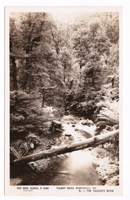
Postcard (item) - Black and white postcard, Rose Stereograph Company, Talbot Drive, Marysville, Vic. No. 3, The Taggerty River, 1913-1967
A postcard in a series produced by the Rose Stereograph Company in Victoria, Australia as a souvenir of Marysville.A black and white photograph taken along Lady Talbot Drive, Marysville, in Victoria, of the Taggerty River. Lady Talbot Drive is a 24 kilometer scenic rainforest car journey which passes a number of walks and waterfalls in the Yarra Ranges National Park. Lady Talbot Drive is named after Lady Sarah Elizabeth, the wife of Sir Reginald Talbot, who was the Governor of Victoria from 25th April, 1904 to 6th July 1908. This postcard was produced by the Rose Stereograph Company as a souvenir of Marysville.POST CARD The "Rose " Series/ De Luxe A Real Photograph/ Produced in Australia Published by the Rose Stereograph Co./ Armadale, Victoria. Dear John,/ I am writing this note in my room/ at Mt. Kitchener House before sallying forth for/ dinner. Unfortunately space does not permit/ me to tell you much, but I must let you know/ that yesterday morning (Monday), a blanket of/ snow covered the township of Marysville to a/ depth of three or four inches. Further up, near/ Keppel's Lookout, which we visited yesterday, it/ was nearly a foot deep everywhere, and it snowed/ the whole time we were walking./ Will tell you all later, your friend, Billtalbot drive, marysville, victoria, taggerty river, p. 2308, rose series postcard, postcard, souvenir, sir reginald talbot, lady sarah elizabeth talbot -
Whitehorse Historical Society Inc.
Map, Yarra River, 1839
Copy of T.H. Nott's original survey of 'Yarra Yarra River' taken from 'Lilydale' by Grace Aveling.Copy of T.H. Nott's original survey of 'Yarra Yarra River' taken from 'Lilydale' by Grace Aveling. Covers area from Templestowe to Yarra Glen.Copy of T.H. Nott's original survey of 'Yarra Yarra River' taken from 'Lilydale' by Grace Aveling. maps, yarra river -
 Kew Historical Society Inc
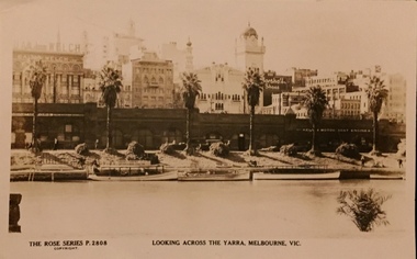
Postcard, Rose Stereograph Company, Looking across the Yarra River, Melbourne, Vic, 1935
One of a number of 'real photo' and commercial postcards created by or owned by members of the Christian and Washfold families of Kew. The postcards are part of a larger collection of photographs, postcards and publications donated to the collection in May 2021.Monochrome postcard of view of the north bank of the Yarra River between Flinders and Russell Streets. Scene shows palm trees, boats and stores under embankmentThe Rose Series P. 2808yarra river, city of melbourne, postcards -- melbourne, christian-washfold collection