Showing 112104 items
matching road
-
 Whitehorse Historical Society Inc.
Document - Correspondence, Healesville Road, 9/04/1937
Claim for reimbursement from the Country Roads Board of amounts expended on the Main Healesville Road by Shire of Blackburn and Mitchamhealesville road, shire of blackburn and mitcham, victoria. country roads board, roads and streets -
Whitehorse Historical Society Inc.
Document - Correspondence, Healesville Road, 26/04/1937
Claim for reimbursement from Country Roads Board for amounts expended on Main Healesville Road by Shire of Blackburn and Mitchamshire of blackburn and mitcham, victoria. country roads board, roads and streets, healesville road -
Whitehorse Historical Society Inc.
Document - Correspondence, Healesville Road, 18/06/1937
Claim for reimbursement from Country Roads Board of amounts expended on Main Healesville Road by Shire of Blackburn and Mitchamshire of blackburn and mitcham, victoria. country roads board, roads and streets, healesville road -
 Whitehorse Historical Society Inc.
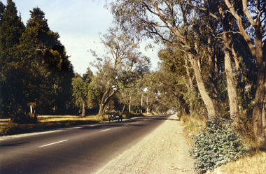
Photograph, Canterbury Road, Vermont, 1967
Part of Tim Shambrook's Collection for 'This is Vermont'. Not used.Coloured photo of Canterbury Road, Vermont, taken in 1967 showing one lane road and heavily treed verge.canterbury road, vermont, shambrook, tim -
 Whitehorse Historical Society Inc.
Photograph, Brunswick Road, Mitcham, 8/09/1958 12:00:00 AM
Black and white photo of Brunswick Road, Mitcham. (Was previously Northcote Road.) Comments as for Forster Street Mitcham. - NP1075.o'rourke, l. -
 Eltham District Historical Society Inc
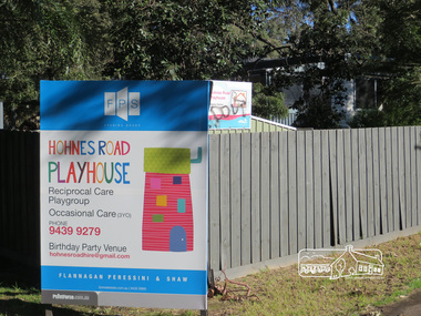
Photograph, Liz Pidgeon, Hohnes Road Playhouse, 1 July 2017
Photo taken as part of an EDHS Heritage Excursion - Saturday 1st July - Eltham Lower Park - Walk and Talk. "Eltham Lower Park has played an important part in the history of our area since the early days of European settlement when it was used by local residents as an informal racecourse. Prior to that its location at the junction of the Diamond Creek and the Yarra River made it an important meeting place for the Wurundjeri people. The park combines formal elements and sporting facilities with remnant bushland that is of environmental significance. It is home to sporting and horse riding clubs, popular play spaces and the Diamond Valley Miniature Railway, which attracts large numbers of visitors.The park will be the venue for our July excursion which will comprise a walk of about 3.5 km around the park and adjacent areas. Along the way we will discuss the history and natural history of the area. The path along the creek and the river provides a pleasant and scenic walk.This walk on Saturday 1st July is about 3.5 km in length and will take 2 to 2.5 hours. It will start at 2pm at the Main Road car park at the front of the park. (Melway ref 21 H 10)". Newsletter No., 234, June 2017 Born Digitalheritage excursion, activities, eltham district historical society, eltham lower park, sign, hohnes road playhouse -
 Ringwood and District Historical Society
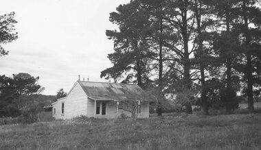
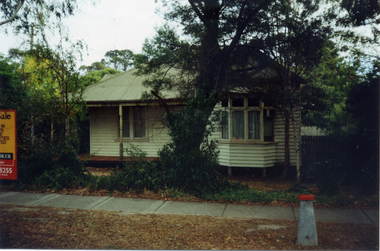
Photograph, House in Mullum Road (undated)
Weatherboard cottage with tin roof amongst pine trees.Typed below photograph, "House in Mullum Road" -
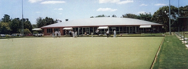 Ringwood and District Historical Society
Photograph, Ringwood Bowling Club- New clubhouse at Loughnan Road, 1997
Colour photograph.The new clubhouse. The synthetic green at Loughnan Road. -
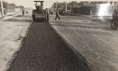 Kew Historical Society Inc
Photograph, City of Kew, Public Works, Road Construction, c.1920s
An original photograph donated to the Kew Historical Society by the City's Engineering Department before the amalgamation of Kew into the City of Boroondara in 1994.While not all of the photographs are of Studley Park, Kew or East Kew, each photo provides a fine snapshot of the work of local government engineering departments of the period. They reveal they types of labour conducted, the techniques used and the equipment and machinery in the possession of the local government authority. Public works. A photograph of a suburban street under construction using a steamroller. Neither the street nor the location has been identified. It is believed that the photograph can be dated to the 1920s. Inscription on reverse: "Road making. (?1920s cars)".steamroller, road construction building, city of kew, city of kew (engineering department) -
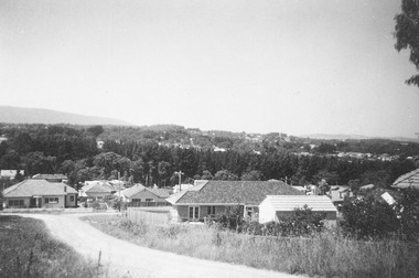
 Ringwood and District Historical Society
Photograph, No.14 Glenvale Road, North Ringwood, towards Mitcham. 1982
Written on back of photograph, "21/4/82. No.14 Glenvale Road towards Mitcham. Deep Creek Road in background left." -
 Ringwood and District Historical Society
Photograph, Jewkes pine forest in Mullum Road. Ringwood. 1958
Written next to photograph, "Jewkes pine forest in Mullum Road. Looking down from Wonga Road to Collett Avenue, 1958." -
Surrey Hills Historical Society Collection
Planning report, City of Boroondara, City of Boroondara planning report re 171 Union Road, Surrey Hills, 19/07/2004
171 Union Road was part of the Thomas Zeplin estate. It originally had a Victorian house on it built by the Zeplin family. This was leased by Dr Percy Liddle and then Dr James Landells Blakie. Dr Blakie purchased land diagonally opposite at 174 Union Road and had a purpose-built home / surgery constructed. Later the site was occupied by COR then a BP petrol station.A detailed proposal regarding the redevelopment of the petrol station site on the corner of Union Road and Montrose Street, Surrey Hills into a 2 storey office and shop building with basement parking and access from Montrose Street. It includes attachments showing plans, elevations and details regarding objectors. The application was granted subject to additional conditions being met. union road, redevelopment, shops, town planning -
 Surrey Hills Historical Society Collection
Photograph, Surrey Hills viewed from 'Quamby' at 293 Mont Albert Road, c 1915, 1915
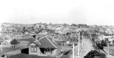
Quamby was built in 1898. From 1900/1903-1924 it was the home of Andrew Sherar and family. From 1924-1960s it operated as Mosgiel Hospital under the direction of Matron Elizabeth Anderson. Until Box Hill Hospital opened most Surrey Hills children were born at Mosgiel or at Nethercourt Hospital in Wilson Street or later in Union Road when Matron Tank moved her hospital here. Mosgiel Hospital was demolished c 1975 after it was sold by Box Hill Hospital. It was replaced by units. Andrew Sherar was conductor of the Wyclif Church choir for many years and was a member of the Melbourne Liedertafel. Isie Sherar was organist at Wyclif Church and also taught piano in Union Road. Connie Sherar was in the Wyclif choir and married Ernest Swan, an elocutionist and orator. Dorothy Sherar was a pianist and accompanist. Elsie Sherar was also in the Wyclif choir and was a soloist; she later moved to Templestowe. Ken Sherar was a boy soprano at St Paul's Cathedral; he later moved to Queensland.Black and white photo looking south down Vincent Street from 'Quamby', located at 293 Mont Albert Road, Surrey Hills. In the centre foreground is a timber house with 2 chimneys and a tiled hip roof. It has a return veranda and is fenced on 2 sides by paling fences and picket fences on the other two. In the background are many more houses. A road lined with power poles runs from the right foreground to the middle distance.quamby, vincent street, edwardian style, topography, andrew sherar, isie sherar, connie sherar, dorothy sherar, ken sherar, elsie wappet -
 Falls Creek Historical Society
Photograph - Upper Kiewa Valley Road, Falls Creek
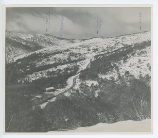
MEYER COLLECTION - FALLS CREEK PHOTOS In 1947 a determined group of like-minded State Electricity Commission (SEC) staff including Ray Meyer, the chief surveyor of the Kiewa Hydro-Electric Scheme, had a common interest that revolved around the skiing potential of the snow-covered high plains which included what is now the resort of Falls Creek. The six SEC employees, Toni St Elmo, Ray Meyer, Jack Minogue, Lloyd Dunn, Adrian Ruffenacht and Dave Gibson (together with their families) banded together to secretly build a 'hut' that was the first ski lodge at Falls Creek. Using a road built in 1930s to gain access to Falls Creek, their hut project was carried out in secret as efforts by other skiers were blocked by H.H.C. Williams – the engineer in charge of the Hydro Scheme. In 1946 Ray Meyer made a trip to the Lands Office in Melbourne. He came away with a 99-year lease on three acres that was ideally suited for a hut designed by Lloyd Dunn. Adrian Ruffenacht (Design Engineer for the KHS) had suggested where the group should build because of easy access to a spring for water. Much of the building material required was scavenged from derelict huts on the high plains. Due to the need for secrecy, the determined group worked on the hut in the evenings and weekends to avoid detection. During the building period the group had met at Echidna Rock (now known as Eagle Rock) where Skippy St Elmo announced, "This is my favourite ‘Skyline’.” And so the first lodge in the area at Falls Creek Ski Resort came into existence. With the development of the International Poma in the 1970s, the Skyline Lodge, which was sited between the ski-lift’s pole one and pole two, was demolished. However, the legacy of Ray Meyer, Toni St Elmo, Jack Minogue, Lloyd Dunn, Adrian Ruffenacht and Dave Gibson and Skyline lives on in the vibrant atmosphere of Falls Creek Resort. The MEYER COLLECTION documents developments on the Kiewa Hydro Scheme and their life at Falls Creek from the mid 1930s to 1960s.This image is significant because it depicts aspects of the life of a pioneering family of Falls Creek and the founders of "Skyline", the first lodge at Falls Creek.A photo of the Upper Kiewa Valley Road, Falls Creek. Arrows have been marked on the photo to indicate key locations. L to R:- Tony's Old place; Windy Corner: Tony's Preb./ Road.falls creek, toni st elmo, toni beveridge hydrographer -
 Melton City Libraries
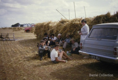
Photograph, Stacking at Ferris Road, Unknown
Hay stacking at Ferris Roadagriculture, local identities -
Whitehorse Historical Society Inc.
Article, Traders seething at trial road closure, 2004
Mitcham traders are opposed to the closure of the service road entrance from Whitehorse Road to McDowall Street for a three month trial.Mitcham traders are opposed to the closure of the service road entrance from Whitehorse Road to McDowall Street for a three month trial.Mitcham traders are opposed to the closure of the service road entrance from Whitehorse Road to McDowall Street for a three month trial.whitehorse road, mitcham, mcdowall street, mitcham, roads and streets -
Whitehorse Historical Society Inc.
Document - Correspondence, Healesville Road, 2/08/1937
Claim for reimbursement from Country Roads Board for amounts expended on Main Healesville and Burwood Roads by Shire of Blackburn and Mitchamshire of blackburn and mitcham, victoria. country roads board, healesville road, roads and streets, burwood road -
Whitehorse Historical Society Inc.
Document - Correspondence, Healesville Road, 16/08/1937
Claim for reimbursement from Country Roads Board for amounts expended on Main Healesville and Burwood Roads by Shire of Blackburn and Mitchamshire of blackburn and mitcham, victoria. country roads board, roads and streets, healesville road, burwood road -
Whitehorse Historical Society Inc.
Document - Correspondence, Healesville Road, 16/11/1937
Claim for reimbursement from Country Roads Board for amounts expended on Main Healesville and Burwood Roads by Shire of Blackburn and Mitchamshire of blackburn and mitcham, victoria. country roads board, healesville road, burwood road, roads and streets -
 Whitehorse Historical Society Inc.
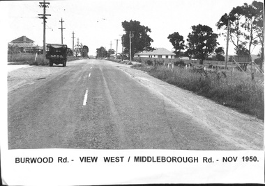
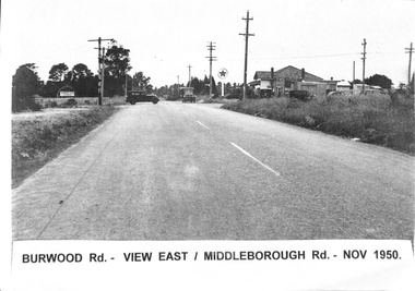
Photograph, Burwood Road - 1950, 1/11/1950 12:00:00 AM
Black & white photograph taken of Burwood Road in November 1950 - View west corner of Middleborough Road, November 1950.burwood road, burwood, middleborough road -
 Whitehorse Historical Society Inc.
Photograph, Burwood Road 1950, 1/11/1950 12:00:00 AM
Black and white photograph of Burwood Road. View east - corner of Middleborough Road Burwood in November 1950. 4 Copies.burwood road, burwood, middleborough road -
 Whitehorse Historical Society Inc.
Photograph, Whitehorse Road Mitcham No.427, 2001
Coloured photograph of 427 Whitehorse Road - corner Dunlavin Road - Mitcham before renovations commenced. Compare with NP2519 & NP2520whitehorse road, mitcham no 427, dunlavin road, mitcham -
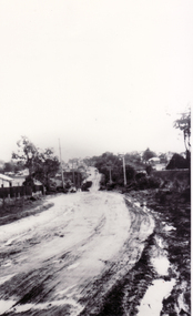
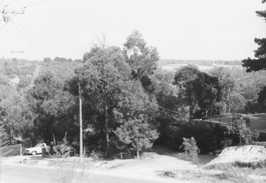
 Whitehorse Historical Society Inc.
Photograph, Deep Creek Road, Mitcham, 1/01/2001 12:00:00 AM
Black and white photograph of Deep Creek Road, Mitcham taken from lower entrance of Schwerkolt Cottage Reserve showing Glenvale Road on left. Photo taken before work started on new road and bridge.deep creek road, mitcham, glenvale road, ringwood -
 Surrey Hills Historical Society Collection
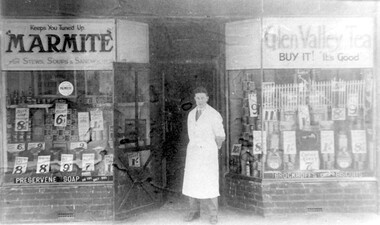
Photograph, Edward Blanchford Wright's grocery shop, Canterbury Road, Surrey Hills
Edward Blatchford Wright was born in 1894 in Birmingham, son of Edward Wright and Florence Emuss. It is not known when he migrated to Australia but he served in the AIF during WW1, seeing action in France. On enlistment aged 20 years 9 months, he gave his occupation as farmer. He married Gertrude Matilda Wain in 1919. He came to Surrey Hills c1924. He was a grocer in the area for several decades with shops in Canterbury Road. In 1942 he is listed at 235 Union Road. This was a residential address. Alan Holt's Surrey Hills property register places him at 365 Canterbury Road (c1920-1930) and 359 Canterbury Road (c1930-1940). He died in 1972 in Mont Albert. His last electoral roll entry in 1968 gives 18 Serpentine Street, Mont Albert. He and his wife are buried in Burwood Cemetery.Black and white photo of the exterior of Edward Blanchford Wright's grocery shop in Canterbury Road, Surrey Hills. The screen door is open and William Reynolds stands in the opening, dressed in a long white coat. The window displays are stacked high with cans and packages and large signs advertising the prices of goods. There is advertising on the windows for Marmite, Glen Valley tea, Preservene soap and Brockoff's biscuits. advertising, shops, grocers, businesses, union road shops, edward blatchford wright, william reynolds, burwood cemetery, world war 1, canterbury road -
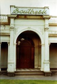 Kew Historical Society Inc
Photograph, Entrance to ‘Southesk’, Cotham Road, 1970
Colour enlargement of a photograph (slide) of Southesk (formerly Ordsall) in Cotham Road, Kew (demolished 1970).Rare colour photograph of the exterior of SoutheskA colour enlargement of the entrance to ‘Southesk’. Formerly known as ‘Ordsall’, the house was built for John Halfey in 1882 on the corner of Cotham Road and Charles Street. This Italianate mansion was built in the Renaissance villa style on a bluestone plinth. The picture provides photographic evidence of the tiling on the veranda and the typically arched doorway. The neon sign above the door was added during the period when it was owned by the City of Kew (1948-70).david carnegie, john halfey, southesk - cotham road - kew (vic), ordsall - cotham road - kew (vic) -
 Eltham District Historical Society Inc
Photograph, Fountain Hotel, Main Road, Eltham
Digitised from scanned print of original postcard of Fountain Hotel, Main Road Eltham (later Evelyn Hotel) early view showing two storey section. Built in 1852 as the Fountain of Friendship Hotel, later named the Fountain Hotel in the 1880s. Located on the southwest corner of Maria (Main) and Pitt streets. Later known as the Evelyn or Evelyn Arms Hotel, it was de-licensed in 1919. The hotel was totally destroyed by fire on Wednesday, February 18, 1931Digital file scan of photo print copy and photocopy of original image of Fountain Hotel, Main Road Eltham (later Evelyn Hotel) early view showing two storey sectionhotels, eltham, fountain hotel, evelyn hotel, main road, pitt street -
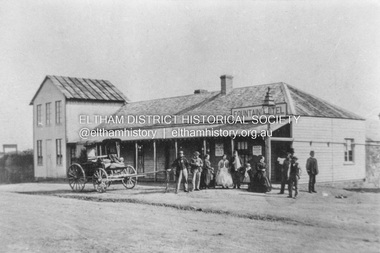
 Eltham District Historical Society Inc
Photograph, Marian Mitchell (nee Robinson), Main Road, Hurstbridge, 7 Aug 1971
Apparently the garage belonged to Peter Brock’s family for which it was locally known and referred to as “Brock’s Garage”."Main Road Hurstbridge" on front On reverse of image: Hurstbridge Main Road Aug 7 1971 Taken by Narian Mitchell (nee Robinson)"fc holden station sedan, hurstbridge, hurstbridge motors, main road, shell service station, peter brock, brock's garage -
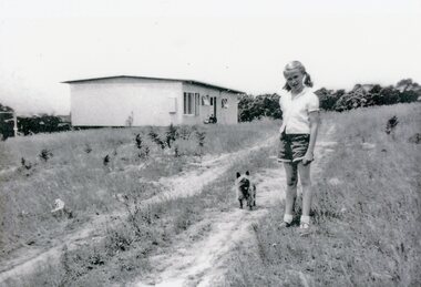 Park Orchards Community House
Photograph, 121 Arundel Road, Park Orchards property in summer 1958, Q4 1958
Catherine O'Connor with "Tinker". The dirt track is Arundel Road. The house is at (Lot 87) 121 Arundel Road, Park Orchards in Summer 1958. -
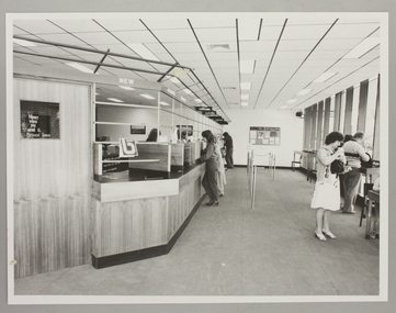 Ringwood and District Historical Society
Photograph, Interior of Ringwood North State Bank , south-east corner of Dickson's Crescent and Warrandyte Road
The new Ringwood North State Bank premises on the south-east corner of Dickson's Crescent. Showing customer service area. Opened 23 August 1982At the corner of Dickson's Cresent and Warrandyte Road, Ringwood North. Photographer - Les Gorrie Photography, 28 Waldemar Road, Heidelberg. Negative #82334 -
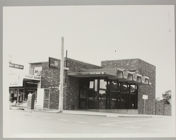 Ringwood and District Historical Society
Photograph, Ringwood North State Bank , north-east corner of Dickson's Crescent and Warrandyte Road
The new Ringwood North State Bank premises, November 1979 on the north-east corner of Dickson's Crescent. Exterior view.At the corner of Dickson's Crescent and Warrandyte Road, Ringwood North. Photographer - Les Gorrie Photography, 28 Waldemar Road, Heidelberg. Negative #2389