Showing 1034 items matching "गुगल ड्रेनेज प्रगति(TG:e10838).gum"
-
 Eltham District Historical Society Inc
Photograph, Liz Pidgeon, Heritage Excursion; East of Eltham, 6 Sep 2014, 20 May 2017
Newsletter No. 218, September 2014 September Excursion - East of Eltham Walk In Newsletter No. 197, March 2011, there was a brief history of Crown Allotment 15 Section 5 Parish of Nillumbik (CA 15) a parcel of land of a quarter of a square mile extending from Eucalyptus Road to Reynolds Road at the eastern extremity of Eltham. From the 1940s it was known as Stokes orchard. In later years it has been subdivided for residential purposes but leaving significant areas as power line and water supply reserves and bushland reserves that are habitat for the threatened For our excursion on 6th September we intend to walk through CA 15 to a bushland reserve east of Reynolds Road. The walk will traverse the boundary between suburban Eltham and the non-urban areas to the south and east. This is a pleasant walk through residential areas and bushland. Along the way we will discuss the early and more recent history of CA 15 as well as local natural history and geology. This walk is about 3.5 km in length and will take 2 to 2.5 hours. It will start at 2pm at the corner of Eucalyptus Road, Pitt Street and Nyora Road.Born Digitaleltham east, eltham district historical society, heritage excursion, activities, nyora road, reynolds road, gum tree road reserve, diosma road, stokes orchard, eucalyptus road -
 Kiewa Valley Historical Society
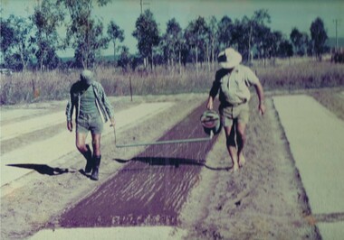
Photograph Tobacco planting, Planting Tobacco seeding, Circa mid to late 1900's
This promotional photograph by the Tobacco Growers Association was in response to a 1935 meeting of tobacco growers from Victoria, South Australia and Queensland which produced four major resolutions for the industry covering the remainder of the 1900s. These four resolutions were: (1) Adequate tariff protection (2) Control of pests and diseases (3) Orderly marketing (4) The formation of an advisory council of growers. History has produced the following results. (1) adequate tariff protection was never achieved,(2) control of disease through benzol vapour (CSIRO) breakthrough, was later identified as carcinogenic, (3) orderly marketing was achieved through (4) the establishment of the Tobacco Growers Association(1984). In October 2006, by way of Government buy back of tobacco leases from growers, resulted in the end of Tobacco farming in Australia (after 136 years of planting the first crop). It was also significant that the major tobacco companies such as Philip Morris and The British American Tobacco Australasia advised the industry that it would source its tobacco requirements overseas by 2009.The remnants of the Tobacco Industry can still be viewed throughout the Kiewa Valley and adjacent regions on the former tobacco farms which still have the tobacco drying sheds and now converted into hay sheds. The problems from the large quantities of carcinogenic infused soil of farmlands in the region, still remains a problem now and for future generations. This particular photograph shows the lack of understanding by farmers and the contracted labour, at that time, and is demonstrated by the bare footed farmer walking next to the seed canister. Some workers did use protective "gum" boots but the majority of farm owners were skeptical of city scientists and their carcinogenic concerns, and it was only after the younger generation of farmers , who had attended Agricultural colleges, encompassed the scientific approach to farm management and began working closely with agricultural scientists. The "she'll be right mate" attitude of the earlier farming/rural community has since mid 1970s, been slowly dissipating. Stricter controls of herbicides and pesticides used in agriculture are now in force. The death of the tobacco industry(2006) resulted in the expansion of the dairy , sheep, beef cattle, venison and lama wool producers in the Kiewa Valley and surrounding regions.Coloured photograph pasted onto a thick wood chip backing. Two galvanised eyelets at the top of the frame, 50mm from each end, with a twine cord stretch from each, for hanging purposes. See also KVHS 0054(B) to KVHS 0054(F)A sign, which has been removed from the picture at some previous point in time is "The Tobacco seed, being so fine, is suspended in water and sown onto the seed base using a watering can [as in the photo] or similar device - August - Sept."tobacco, farming, rural industry, licences, ollie mould, blue mould, benzol vapour -
 Marysville & District Historical Society
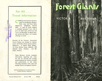
Ephemera (Item) - Information brochure, Victorian Government Tourist Bureau, Forest Giants Victoria Australia, 01-1938
An information brochure on where to see tall trees, Forest Giants, in Victoria, including Marysville, that was published in January, 1938.An information brochure on where to see tall trees, Forest Giants, in Victoria, including Marysville, that was published in January, 1938.Victorian Railways Print January, 1938 469-38 Stamp of Victorian/ Government Tourist Bureau/ 272 Collins Street/ Melbourne C.1victoria, australia, victorian government tourist bureau, betterment and publicity board, victorian railways, white mountain ash, red mountain ash, messmate, blue gum, mountain ash, cumberland valley, marysville, mount monda, healesville, acheron way, alpine highway, omeo, baw baws, strzelecki ranges, otway ranges, warburton, yarra junction, noojee, bulga and tarra valley park, yarram, turton's pass, otway forest, beech forest, apollo bay, information brochure, brochure -
 Marysville & District Historical Society
Map (Item) - Tourist map, Mystic Mountains Tourism, OFFICIAL VISITORS' MAP MARYSVILLE LAKE MOUNTAIN, Unknown
A visitors' map of Marysville and Lake Mountain produced by Mystic Mountains Tourism for Visit Victoria.A visitors' map of Marysville and Lake Mountain produced by Mystic Mountains Tourism for Visit Victoria.The Marysville and Lake Mountain Visitor Map and Touring Guide has been compiled and/ published by Mystic Mountains Tourism Inc. Copyright./ Production and artwork Graph Attack P/Lmarysville, lake mountain, victoria, australia, visitor's map, official visitors' map marysville lake mountain, buxton, narbethong, taggerty, visit victoria, mystic mountains tourism inc, graph attack p/l, mystic mountains, marysville triangle, marysville visitor information centre, marylands country house, black spur, steavenson falls, lady talbot drive, cambarville, cathedral ranges, wirreanda festival, lake mountain summit walk, summit walk loop, leadbeaters loop, day loop walk, buxton hotel, igloo roadhouse, karmann waters, silverstream b&b cottages, buxton trout and salmon farm, the niche wine bar, buxton post office & general store, choppers buxton roadhouse, woodlands rainforest bungalows, chestnut glade, black spur inn, wombat cottage, abbey lake luxury b&b spa cottages, mystic mountain ski hire & outdoors, pnl 4wdriving, blue views holiday units & ski hire, marapana agistment park & farm stay b&b, danico design, things of sand & stone, mantirri blueberry farm, allawah country cottages, amberview cottages, ashlar cottage b&b, black spur motel & caravan park, blackwood deluxe cottages, blackwood courtyard b&b, dalrymples guest cottages, delderfield, el kanah guest house, fruit salad farm, kerami guest house, keppels hotel, lake mountain-snow gum lodge, lomatia lodge, lyell guest cottages, magnolia house, keppel waters, lyrebird apartments, marysville caravan park, all view spa apartments, riverside cottages, maryton park b&b country cottages, melina cottage, mountain lodge, mystic mountains holiday cottages, nanda binya lodge, rendezvous luxury cottages, scenic b&b motel, the cumberland, south cathedral farm, tower motel, willowbank at taggerty, woodlands rainforest retreat, marysville & district country club inc, mystic mountains ski hire & outdoors, rubicon valley horse riding, marysville trout and salmon ponds, gallipoli park, keppels lookout, cambarville-yarra ranges national park, lake mountain-yarra ranges national park, lady talbot drive-yarra ranges national park, cathedral range state park, steavenson river, taggerty river, acheron river, lake mountain alpine resort, bruno's art and sculpture garden, manical mechanicals, uncle fred & aunty val's old style lolly shop, carmyle farm boutique, crossways historic country inn, fraga's, gilberts restaurant, heights licensed bistro, the old woolshed cafe, cathedral view natural therapies, crystal journey -
 Eltham District Historical Society Inc
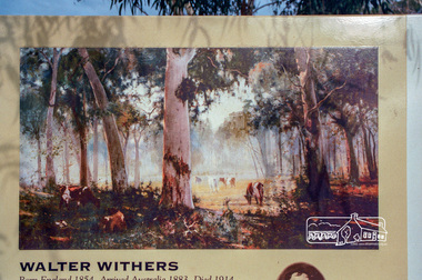
Photograph, Heidelberg Artists Trail sign, "The Silent Gums" Walter Withers 1909, Wingrove Park, Eltham, c.May 2001
The Heidelberg School Artists Trail was established in about 1999 with about 52 signs across four local governemnt areas including Nillumbik and Banyule. This one located in Wingrove Park Eltham pays tribute to Walter Withers and his painting "The Silent Guns"Roll of 35mm colour negative film, 7 stripsAgfa HDC 200 plus-2eltham, heidelberg artists' trail, wingrove park trail, walter withers, the silent gums -
 Federation University Historical Collection
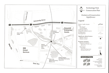
Document - Plan, Mathew Gibson, Centre for Environmental Management, Ballarat Technology Park Conservation Plan, 1997, 1997
The Ballarat Technology Park is on the Mount Helen Campus.A4 photocopy of a plan of the Ballarat Technology Park showing features of conservation significance. The plan includes the Canadian Creek, an historic hand-made brick culvert, Canadian Wetland Development, early wooden bridge, old path of the Ballarat-Buninyong Railway line, Greenhill Enterprise Centre and IBM Global Services.ballarat technology park, greenhill enterprise centre, ibm global enterprises, ballarat-buninyong railway line, canadian wetlands, brick railway culvert, canadian creek, riparian woodland, yarra gum, swamp gum, blackwood, remnant vegetation, scent bark, narrow-leaf peppermint, messmate, centre for environmental management, mount helen campus -
 Federation University Historical Collection
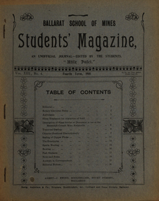
Magazine - Booklet, Ballarat School of Mines, Student Magazine, Fourth Term, 1910, 1910
Table of Contents: Editorial, Rotary converter notes, Ambulance, Slime treatment for attraction of gold, Description of slime settler or dewaterer in use at the Brownhill Consols mine Kalgoorlie, Transvaal geology, Chlorine produced electrolytically, Scaling of copper plates, The eucalyptus, Sports meeting, Rowing, Past students, News and notes, Answers to correspondents, Editorial notices. Images.Magazine of 24 pages. Page 17 lists the whereabout of past Ballarat School of MInes students: J.R. Booth, W.t. Lakeland, Lewis Westcottm Leo M. Seward, Reginald Williamson, Stanley White, Clyde Allan, Charles Lamb, W.E. Eyres, Virgil Tucker, H. Hawkesworth, H.J. Saw, Fred G. Brisnden, C. Stevenson, Fred Treloar, J. Peart, E.M. Weston, Dick Galloway, H.B. Bennetts, G.R. Curry, H. Meadows, Eric Bieske, Cliff Garrard, Phil Brown, Lindsay D. Cameron, Phil Brown,, W.P. Avery, J. Foster, J. Bickett, F.H. Inglis, G. Devenport, t. lennon, h. wilkins, g.h. reid, c. hesselman, E. Fraser, Reginald Callister, F. Bicknell, Leslie Blick, W.T. Sayer, W.F. Hall, O.e. Jaeger, W. Gelard, P.C. Downes, G. Sides, F. Bruce, Frank Bruce.rotary converter, ambulance, slime treatment for attraction of gold, slime settler or dewaterer, brownhill consols mine kalgoorlie, transval geology, chlorine produced electrolytically, scaling of copper plates, eucalyptus, alumni, rollo e. huntley, j.r. booth, w. t. lakeland, lewis westcott, leo m. seward, reginald williamson, stanley white, clyde allan, charles laird, w. e. eyers, virgil tucker, h. hawkesworth, h. j. saw, fred g. brinsden, c. stevenson, fred treloar, j. peart, e. m. weston, dick galloway, h. b. bennetts, g. r. curry, h. meadows, will watson, don cameron, eric bieske, cliff garrard, lindsay d. cameron, phil brown, w. p avery, j. foster, james bickett, f. h. inglis, g. davenport, l. c. courbould, t. lennon, h. wilkins, g. h. reid, c. hesselmann, e. fraser, reginald callister, f. bicknell, leslie blick, w. t. sayer, h. f. hall, o. e. jaeger, w. geldard, p. c. downes, g. sides, f. bruce, e. c. hurdsfield, william baragwanath, r. i. moore, j. l. sampson, h. conran, w. gelard, frederick j. martell, h. cornell, g.c. klug, great fingall consolidated ltd, transvaal geology, eucalyptus gum tree, w.t. lakeland, lewis westcottm leo m. seward, charles lamb, w.e. eyres, h.j. saw, fred g. brisnden, e.m. weston, h.b. bennetts, g.r. curry, w.p. avery, j. bickett, f.h. inglis, g. devenport, g.h. reid, c. hesselman, w.t. sayer, w.f. hall, o.e. jaeger, p.c. downes, frank bruce., mt morgan, kalgoorlie, mt elliott copper mine, ballarat city baths, r.b. young -
 Federation University Historical Collection
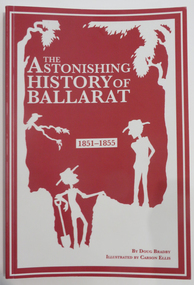
Book - Booklet, Seriously History Press et al, The Astonishing History of Ballarat: 1851-1855, 2018
Book with red and white cover.port phillip, california, ballarat, thomas chapman, john kelly, strath loddon, louis michel, william habberlin, james esmond, george bruhn, thomas hiscock, john dunlop, james regan, james oddie, herbert swindell, tom toddleton, buninyong, tom brown, squatters, alfred clarke, paul gooch, john hall, eureka stockade, harrie wood, william akehurst, monster nuggets, john evans, daniel evans, thomas george gough, william john gough, sarah sands, john lees, william green, canadian nugget, bob fee, henry gunn, michael welsh, benjamin robertson, thomas carroll, white horse ranges, little bendigo, red hill, john vinvent brewer, george noble, w.h. ferrier, john alloo, peter lalor, john basson humffray, raffaello carboni, james rice, john yates, thomas bath, gum-tree flat -
 Federation University Historical Collection
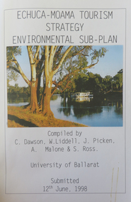
Report, Echuca Moama Tourism Strategy Environmental Sub-Plan, 1993, 12/06/1998
Report compiled by five students of Tourism at the University of Ballarat (later Federation University Australia).victorian tourism industry, tourism, alumni, echuca, moama, hopwood's ferry, murray river, goulburn river, campaspe river, gaming, port of echuca, river red gums, wetlands, emmy lou, paddle steamer, star hotel, echuca farmyard, echuca coach house -
 Federation University Historical Collection
Magazine, Ararat: The Guide, 2000-2001
Yellow and blue soft covered Ararat Community Directoryararat, community directory, gwenda allgood, paul hooper, pat mcaloon, steve shannon, peter o'rorke, ted millear, geoff king, bill braithwaite, ian couper, ian manley, annette newton, lesley harvie, j ward, david hawker, dianne hadden, bruce chamberaine, joe helper, john mcquilten, denis napthine, roger hallam, ararat advertiser, ararat community college, ararat map, grampians soaring club, ararat gaol, ararat town hall, gum san museum, chinese -
Federation University Historical Collection
Booklet, Charles Barrett, The Sun Tree Book - Sun Nature Book No. 8, 1936
Paperback booklet with trees printed on front cover and advertisement for Rimington's Nurseries on the backcover. 44 pages. The book included a foreword from A.V. Galbraith, Chairman of the Forests Commission of Victoria.trees, botany, plants, grey box, gum nuts, elms, conifers, currajong, atlantic cedar, western yello pince, stone pine, deodar, bunya bunya pine, sequoia, wattle, black wattle, blackwood, cumberlad valley, banyan, jungle fig, lombardy polar, honysuckles -
 Federation University Historical Collection
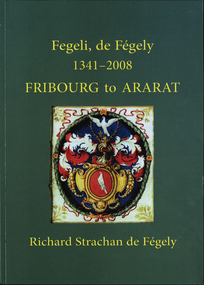
Book, Richard Strachan de Fegely, Fegeli, de Fégely, 1341-2008 : Fribourg to Ararat, 2009, 2009
Green soft covered book covering the history of the de Fegely family from Fribourg, Switzerland, to Ararat, Victoria. de fegely, fribourg, ararat, university of ballarat council, swiss guards, strachan, de casetlla, quamby, ballarat technology park, honorary doctorate, gum san chinese heritage centre, admiral richard strachan, melbourne international exhibition, carre riddell, herbert werner frederick de nully, vignerons, malta, family history, genealogy -
Australian Commando Association - Victoria
Plaque - Shell Casing with Red Gum Projectile
-
 Bendigo Historical Society Inc.
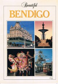
Book - PICTURES AND ATTRACTIONS OF BENDIGO: BEAUTIFUL BENDIGO
Booklet (18 pages) ''Beautiful Bendigo'' - coloured pictures of Bendigo and attractions with one page foreword. Published in association with the Bendigo and District Tourism Association, 1987. Includes city map at back of booklet.Printed in Singapore by Toppan Printing Company. Published by Robert Brown & Associated (Aust) Pty Ltd.bendigo, tourism, guide, tramways, george lansell, gold mines hotel, specimen cottage, queen elizabeth oval, secred heart cathedral, camp hill primary school, public library, conservatory gardens, school of mines. central deborah mine. dai gum san wax museum, kwan gung joss house, bendigo's sun loong dragon. sandhurst town, map of bendigo. -
 Bendigo Historical Society Inc.
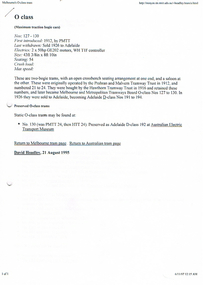
Document - LONG GULLY HISTORY GROUP COLLECTION: TRAMS INFORMATION
Information on O Class Trams, First introduced, Last Withdrawn, Electrics, Size and Seating, W2 with a small photo, where they can be found, some went to the USA, W5 with a small photo, W6 and the Bendigo Toastrack Tram with Nos, Introduced, Withdrawn, Electrics, Size and Seating/Crush Load. Also listed is where other trams can be seen. Also mentioned some early history of Bendigo, The Heritage Walk, The Central Deborah, Sandhurst Town, the early route from Melbourne to Bendigo, Creswick, Castlemaine and the Old Market. (7 pages).bendigo, history, long gully history group, the long gully history group - trams information, prahan and malvern tramway trust, hawthorn tramway trust, melbourne and metropolitan tramways board, australian electric transport museum, david hoadley, tramway musuem of victoria, hawthorn tram depot, david bromage, sydney tramway museum, bendigo tramways, museum of transport and technology nz, whiteman park tramway museum, haddon tramway museum, the old canberra tram company, ballarat vintage tramway, bendigo toastrack tram, kilmore cable tramway, railway museum, scienceworks, tasmanian transport museum, launceston tramway museum society, ballarat vintage tramway, central deborah gold mine, chinese joss house, castleton, sandhurst, shamrock hotels, dai gum san wax museum, post office, law courts, alexandra fountain, beehive store, fortuna villa, sandhurst town -
 Bendigo Historical Society Inc.
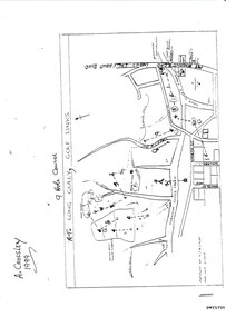
Document - LONG GULLY HISTORY GROUP COLLECTION: THE LONG GULLY GOLF LINKS
Some history of the Long Gully Golf Links, a 9 Hole Course, by John Harvey. First page has a map of the area showing where the holes are and different features. There is a description of the tees and the route taken around the course.Dates when the Eaglehawk, Neangar park, Kangaroo Flat Golf Clubs and the Long Gully Playground were opened.bendigo, history, long gully history group, the long gully history group - the long gully golf links, a crossley, john harvey, long gully rec, dai gum san reservation, quarry hill golf club, bendigo golf club, marong gulf club, miss colgan, sacred heart cathedral choir, mechanics institute, rose of australia hotel, north hercules and energetic mine site, les thomas, tom austen, pearl south mullock heap, doc catford, clubs wearne, pearl mining co's diggings, pearl south, pearl east, bill and faye osterfield, ellen lee osterfield, eaglehawk gold club, neangar park golf club, f m fitzpatrick, kangaroo flat golf club, long gully playground, pearl sands, ennor brothers, birchmore brothers, shirley harvey, belvoir park, harold ennor, george ennor -
Port Melbourne Historical & Preservation Society
Document - Forms of Contract, J Kitchen & Sons, The London Oil and Tallow Trades Association, Aug 1955
Green covered book of "Forms of Contract". Black binding along spine. Each form is numbered and headed with name of commodity for which a contract would be needed . Back of each page has "Rules of Arbitration and Appeal"The London Oil and Tallow Trades Association forms of contract 1955. 84 Leadenhall St, London, EC 3industry - manufacturing, j kitchen & sons pty ltd, coconut oil, vegetable oil, australasian tallow, english tallow, american spirits of gum turpentine, gum rosin, wood rosin, china wood oil, hardened oriental fish oil, linseed oil, south american matadero beef tallow, whale oil