Showing 11287 items matching " government"
-
 Bendigo Historical Society Inc.
Map - CAMPBELL COLLECTION: BENDIGO AND DISTRICT MAPS, August 1952
Map. Nerring, County of Bendigo, Yarraberb, Neilborough, Leichardt, Marong, Sandhurst, Huntly. Scale 20 chains to 1 inch. Drawn and reproduced at the Department of Lands and Survey, Melbourne, Victoria, August 1952. Price 2/-. By Authority J.J. Gourley, Government Printer, Melbourne. (number 404 in map cupboard 1)J.J. Gourley, Government Printermap, bendigo, allotments -
 Port Melbourne Historical & Preservation Society
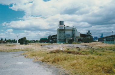
Photograph - Australian Government Engine Works, c.1985
Commonwealth Government Engine Works prior to demolitionAustralian Government Engine Works, Port Melbournecommonwealth government engine works -
Bendigo Historical Society Inc.
Map - LOCKWOOD : COUNTY OF BENDIGO, 2=7-18
Map. Lockwood, County of Bendigo. Marong, Shelbourne, Ravenswood, Mandurang. Photo- Lithographed at the Department of Lands and Survet, Melbourne by W.J. Butson 2-7-18. By authority A.J. Mullett, Government Printer, Melbourne. Price 1/-. (number 69 in map cupboard 1)A.J. Mullett, Government Printer, Melbourne.map, bendigo, lockwood -
Bendigo Historical Society Inc.
Map - TALAMBE : COUNTY OF BENDIGO, January 1956
Map. Talambe, County of Bendigo, Hayanmi, Dingee, Tandarra, Yallook, Pompapiel, Calivil. Drawn and reproduced at trhe Department of Lands and Survey, Melbourne. January 1956. Price 2/-. By authority W.M. Houston, Government Printer, Melbourne. (number 23 in map cupboard 1)W.M. Houston,Government Printer, Melbourne.map, bendigo, talambe -
Bendigo Historical Society Inc.
Map - WELLSFORD : COUNTY OF BENDIGO, 15-12-41
Map. Wellsford, County of Bendigo, Bagshot, Ellesmere, Axedale, Strathfieldsaye, Huntly, Sandhurst. Drawn and reproduced at the Dept. of Lands and Survey, Melbourne.15-12 41. Price 2/-. By authority H.E. Daw, Government Printer, Melbourne. (number 20 in map cupboard 1)H.E. Daw, Government Printer,Melbourne.map, bendigo, wellsford -
 Surrey Hills Historical Society Collection
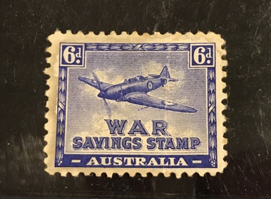
Work on paper - War Savings Stamp, 6d WW2 war savings stamp, 1941-1944
These stamps were issued during WW2 and designed to be stuck into a war savings stamp booklet. When these were filled, you could redeem them for a £1 or £5 War Bond. This specimen is not watermarked indicating it was a re-issue of the earlier version with a watermark. Issued between August 1941 and March 1944. Designed and produced by the Government Stamp Printer. Although the stamp has been called the "Spitfire" for over 70 years, the image of the plane depicted is either a Boulton-Paul Defiant (with a turret mounted behind the cockpit) or a Hurricane rather than a Spitfire. A 6d stamp Australian War Savings stamp in Imperial Blue and white. Loosely held in a philatelic mount. stamps, war savings stamps, planes, second world war, fundraising -
 Ballarat Tramway Museum
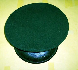
Uniform - Cap, Commonwealth Government Clothing Factory Melbourne, 1950's
3044.1 SEC (Geelong) Motorman/Drivers/Conductors cap - green cloth exterior, grey cotton interior lining, brown leather internal hat band, black cotton hat band on exterior. Black plastic peak fitted with cap or with four holes for the employee badge number in the centre of the cap above the hat band. Sewn on the inside is a label "Commonwealth Government Clothing Factory Melbourne" and stamped "7 3/8". The plastic band at the front half of the cap terminating in two small SEC metal buttons on either side is not present. The holes for this are not visible - may not have been present on Geelong caps? 3044.2 - two small SEC Button badge - nickel plated silver with "Stokes" "Vic" stamped on rear. See also Reg. Item 2894 for a Ballarat Cap. On inside of leather hat band in ink "Mr. R. Evans" and "90 Albert St. West Geelong".tramways, trams, uniforms, cap badge, cap -
 Ballarat Tramway Museum
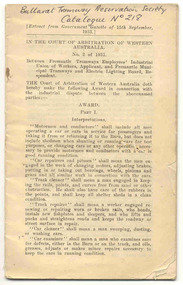
Book, WA Government Printer, "Between Fremantle Tramways Employees' Industrial Union of Workers, Applicant and Fremantle Municipal Tramways and Electric Lighting Board, Respondent", 1933
Thirty four page (page 33 and 34 adhered to back of book as a single sheet), saddle stapled, off white paper, titled "Between Fremantle Tramways Employees' Industrial Union of Workers, Applicant and Fremantle Municipal Tramways and Electric Lighting Board, Respondent", agreement, No. 2 of 1931, extract from the Government Gazette of 15/9/1933. Details definitions of all workers covered by the award, hours of work, roster duty, duty hours, days off, meal relief, reports, uniforms, one man car, shorts and overs, Sunday and overtime, hours of work for carbarn staff, tradesmen and electrical, annual leave, holidays, change of shifts, absences, Board of Reference, wages schedules for various employees, juniors and apprentices, apprenticeship ( a lot of detail on this - about half the book)."Ballarat Tramway Preservation Society Catalogue No. 218" in ink on top of first page. Wage schedule has been updated in ink.trams, tramways, fremantle, fremantle, unions, agreements -
Lakes Entrance Historical Society
Book, Commonwealth of Australia, Style Manual for authors, editors and printers, Third Edition, 1978
A style manual to encourage consistency of editorial style in Australian government publications, and providing a guide to the best typographical and printing practices.directories, government -
Bendigo Historical Society Inc.
Map - DARGILE : COUNTY OF BENDIGO, November 1953
Map. Dargile, County of Bendigo, County of Rodney, Cornella Creek, Northern Highway, Crosbie, Redcastle, Knowsley East, Heathcote, Costerfield, Moormbool West. By authority W.M. Houston, Government Printer. Drawn and reproduced at the Department of Lands and Survey, Melbourne. November 1953. Price 2/-. (number 115 in map cupboard 1)W.M Houston, Government Printermap, bendigo, dargile -
Bendigo Historical Society Inc.
Map - HAWKESTONE : COUNTY OF BENDIGO, December 1953
Map. Hawkestone, Parish, County of Bendigo, County of Talbot, Sutton Grange, Redesdale, Faraday, Elphinstone, Metcalfe, Lyell, Coliban River, Myrtla Creek. By Authority W.M. Houston, Government Printer. Drawn and reproduced at the Department of Lands and Survey, Melbourne. December 1953. Price 2/-. (number 99 in map cupboard 1)W.M. Houston, Government Printer.map, bendigo, hawkestone. -
Bendigo Historical Society Inc.
Map - HEATHCOTE : COUNTY OF BENDIGO, 19-2-1942
Map. Heathcote, County of Bendigo. County of Dalhousie, McIvor Creek,Wallan and Bendigo Railway, By authority H.E. Daw, Government Printer, Melbourne. Drawn and reproduced at the Department of Lands and Survey, Melbourne. 19-2-1942. Price 2/-. (number 90 in map cupboard 1)H.E. Daw, Government Printer, Melbourne.map, bendigo, heathcote -
Bendigo Historical Society Inc.
Map - SEDGWICK : COUNTY OF BENDIGO, 1963
Map. Sedgwick, County of Bendigo, Strathfieldsaye, Mandurang, Sutton Grange, Lyell, Eppalock County of Talbot Border. By authority A.C. Brooks, Government Printer, Melbourne. Drawn and reproduced at the Department of Lands and Survey, Melbourne.1963, Price 2/-. (number 30 in map cupboard 1)A.C. Brooks, Government Printer, Melbourne.map, bendigo, sedgwick -
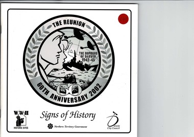 Lara RSL Sub Branch
Boolet signs of History, The Reunion 60th Anniversary 2002 - The Bombing of Darwin 1942 -45 - Signs of History, Circ 1999
Booklet produced by Northern Territory Government and Darwin City Council.A photographic record of the Northern Territory During World War 11.Laminated Cardboard Cover - with 56 paper pages inside. Signs of History - A Photographic Collection of World War 11 Historiic sites signs in the Northern Territory 1999. Produced by Northern Territory Government 1999. Contains photographic images of areas in the Nortthern Territory specific to the operations and actions during the World War 11.Cover of the booklet Title is "Signs of History" on the center lower section above is a circular artistic laurel with heading 'The Reunion - 60th Anniversary 2002" - the inner of the circle "The Bombing of Darwin 1942 - Northern Territory Government and Darwin City Council.northern territory government, dawin city council, the reunion 60th aviversary 2002, signs of history, the bombing of darwin 1942 - 45 -
Bendigo Historical Society Inc.
Map - PANNOOMILLOO : COUNTY OF BENDIGO, 1957
Map. Pannoomilloo, County of Bendigo, Pannoobamawm, Milloo, Diggorra, Warragamba. Elmore Cohuna Railway. Waranga Mallee Channel. By authority W.M. Houston, Government Printer, Melbourne. Drawn and reproduced at the Department of Lands and Survey, Melbourne 1957. Price 2/-. (number 83 in map cupboard 1)W.M. Houston, Government Printer, Melbourne.map, bendigo, pannoomilloo -
Bendigo Historical Society Inc.
Map - NOLAN : COUNTY OF BENDIGO, 22-7-13
Map. Nolan, County of Bendigo, Egerton, Elmore, Goornong, Northern Railway, Campaspe River. By authority A.J.Mullett, Government Printer, Melbourne. Photo-Lithographed at the Deptartment of Lands and Survey, Melbourne by W.J. Butson 22-7-13. Price 1/-. (number 79 in map cupboard 1)A.J. Mullett, Government Printer, Melbourne.map, bendigo, nolan -
Bendigo Historical Society Inc.
Map - NOLAN : COUNTY OF BENDIGO, 7-5-30
Map. Nolan, County of Bendigo, Egerton, Elmore, Goornong, Campaspe River, Northern Railway. By Authority H.J. Green, Government Printer, Melbourne. Drawn and reproduced at the Department of Lands and Survey, Melbourne, Victoria.7-5-30. Price 2/-. (number 78 in map cupboard 1)H.J. Green, Government Printer, Melbourne.map, bendigo, nolan -
Bendigo Historical Society Inc.
Map - CAMPBELL COLLECTION: BENDIGO AND DISTRICT MAPS, 1962
Map. Mandurang, County of Bendigo. Scale 40 chains to 1 inch. Sandhurst, Strathfieldsaye, Sedgwick, Sutton Grange, Ravenswood, Lockwood, Township of Kangaroo Flat, Township of Mandurang. By Authority A.C. Brooks, Government Printer, Melbourne. Drawn and Reproduced at the Department of Lands and Survey, Melbourne,1962, Price 2/-. (number 401 in map cupboard 1)A.C. Brooks, Government Printer.map, bendigo, allotments -
Bendigo Historical Society Inc.
Map - HARCOURT, December 1951
Harcourt, County of Bendigo, Walmer, Castlemaine, Sutton Grange. Mt.Alexander Trig. Station, Barkers Creek, Faraday, Calder Highway, Northern Railway. By Authority J.J.Gourley, Government Printer, Melbourne,Drawn and Reproduced at the Dept. of Lands and Survey, Melbourne, Victoria. December 1951. Price 5/-per sheet. (number 35 in map cupboard 1)J.J.Gourley, Government Printer, Melbourne.map, bendigo, harcourt -
 Melbourne Tram Museum
Document - Instruction, Victorian Government, "Regulations under the Melbourne and Metropolitan Tramways Act 1928 (No. 3732) Appeal Board", 1935
Instruction - booklet - 16 pages, centre stapled, printed on off white paper titled "Regulations under the Melbourne and Metropolitan Tramways Act 1928 (No. 3732) Appeal Board". Gives details of the Regulations in relation to the personnel appeal board, members, election of an employee representative, the appeal board processes and arrangements. Dated 29/1/1935, extract from Government Gazette of 6/2/1935. Additional copy of booklet within a card board folded with amendments provided by donation of Ann and Rob Kuffer 22/2/2019. Amendments are: .1 - typed and pasted over page 3, amendment dated 14/5/1947 - appeals and appointment of Members. .2 - appeals in general - dated 28/2/1961 .3 - undated printed on a folded quarto sheet - titled "Boards Appointed and Commissions Issued by the Governor In Council"trams, tramways, employees, appeals, discipline, mmtb, regulations, elections -
 Montmorency–Eltham RSL Sub Branch
Map - Framed Japanese Map of Darwin Circa 1942, WW2 Japanese Map of Darwin, Estimated date 1940-41
Returned to Australia, from America, where it had been brought back from Japan.Framed map of Darwin with Japanese overprint.'This map is a proof copy of a Japanese Reprint of an Australian map of Darwin.'darwin, world war two, japan, australia, 1942, 1941, maps -
Glenelg Shire Council Cultural Collection
Book, H.J. Green, Government Printer, Melbourne, The Victorian Statutes 1929, Vol III, 1929
Fawn cloth bound, spine and covers. Black text on spine. The General Public Acts of Victoria in 5 Volumes.victorian government, state government, administration, governance -
Glenelg Shire Council Cultural Collection
Book, H.J. Green, Government Printer, Melbourne, The Victorian Statutes 1929, Vol IV, 1929
Fawn cloth bound, spine and covers. Black text on spine. The General Public Acts of Victoria in 5 Volumes. -
4th/19th Prince of Wales's Light Horse Regiment Unit History Room
Data Card (3 copies), US Government Printing Office, Firing Tables for Rifle 106mm M40 firing Cartridge HEP-T M346, 1955
Data card giving the required elevation for the weapon over various ranges from 0 to 7515 yards. It also gives drift, probable error and time of flightFT106-B-2106 mm rcl, firing tables -
 Monbulk RSL Sub Branch
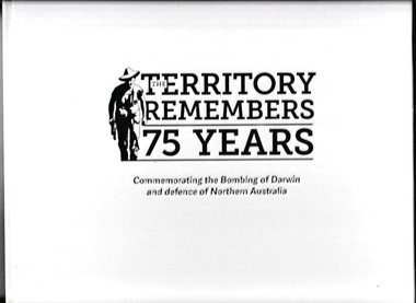
Book, Northern Territory Government, The Territory Remembers 75 Years : Commemorating the Bombing of Darwin and Defence of Northern Australia, 2017
On 19th February 1942, Australia came under air attack for the first time when Japanese forces mounted two air raids on Darwin. On that day, 242 Japanese aircraft attacked Darwin in an attempt to prevent the Allies from using it as a base. 235 people were killed in the two raids, and more than 400 were wounded, 30 aircraft were destroyed, nine ships were sunk in Darwin harbour and two outside, and many civil and military facilities in Darwin were damaged. This book provides a visual record of that time through photographs, some depicting the devastation of war brought to Northern Australia, while others capture how life was for so many during this time.Ill, p.109.On 19th February 1942, Australia came under air attack for the first time when Japanese forces mounted two air raids on Darwin. On that day, 242 Japanese aircraft attacked Darwin in an attempt to prevent the Allies from using it as a base. 235 people were killed in the two raids, and more than 400 were wounded, 30 aircraft were destroyed, nine ships were sunk in Darwin harbour and two outside, and many civil and military facilities in Darwin were damaged. This book provides a visual record of that time through photographs, some depicting the devastation of war brought to Northern Australia, while others capture how life was for so many during this time.world war 1939-1945 - darwin - history, darwin - bombimg - 1942 -
Koorie Heritage Trust
Pamphlet, Government of Australia, The Aborigines and You, 1963
another phamplet issued by the Government to promote assimilation.p.33; illus; 20 cm. another phamplet issued by the Government to promote assimilation.assimilation - australian aborigines, government policy - assimilation -
 Kilmore Historical Society
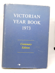
Victorian Year Book 1973, Victorian Year Book 1973, Centenary Edition, No. 87, 1973
Centenary Edition traces the major environmental, social, economic, and technological factors which have affected the State of Victoria. Gives an historical perspective of these developments.Hardcover with dust jacket worn at edges. Illustrated, photos, charts. Excellent condition. 1261 pp.'D $6.00" front flyleaf.year book 1973, victoria -
 Kilmore Historical Society
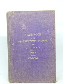
A Handbook of the Destructive Insects of Victoria, A Handbook of the Destructive Insects of Victoria. Part 1, 1891
Hand book of the destructive pests of Victoria, with notes on the methods to be adopted to check and extirpate them. Prepared by order of the Victorian Department of Agriculture.Purple cloth-covered hard cover book. 153 pp. including appendices. Indexed. Illustrated. Good condition.Inside flyleaf 'M. Figgins/Kilmore'.insects, victoria, figgins -
 Victorian Railway History Library
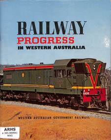
Book, Western Australian Government Railways, Railway Progress in Western Australia, 1964
A promotional book by the Western Australian Government Railways about progress in the railways over the last 85 years up to 1963.ill, maps, p.40.non-fictionA promotional book by the Western Australian Government Railways about progress in the railways over the last 85 years up to 1963.railway history - western australia, railway construction - australia -
 Victorian Railway History Library
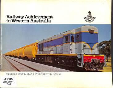
Book, Western Australian Government Railways, Railway achievement in Western Australia, 1966
A promotional book by the Western Australian Government Railways about progress in the railways up to 1966.ill, maps, p.32.non-fictionA promotional book by the Western Australian Government Railways about progress in the railways up to 1966.modern railways - western australia, railway achievements - western australia