Showing 999 items
matching government printer
-
 Port Melbourne Historical & Preservation Society
Book - Borough of Port Melbourne Valuation, 1893
Valuation book, Borough of Port Melbourne 1893. Solid bluegreen cloth cover with maroon spine, gold-stamped. 177 spreads completed listing name and occupation of tenant and owner of each property, description, number of rooms, size of property, rental etc. (also Rates; assessments) p 181: "701.180 taken out for for printers copy 10/9/94 F.C.C" Signed p177 by Mayor and Town Clerk.local government - borough of port melbourne, built environment, edward c crockford, town clerks, john finlay malcolmson, joseph turner -
Port Melbourne Historical & Preservation Society
Book - Town of Port Melbourne Valuation, 1896
Valuation book, Town of Port Melbourne 1896. Red (decorative) cover with beige paper label handwritten in brown ink "Valuation 1896/7"; maroon spine. 2 page insert pasted into spread 72 being letter from valuer handwritten on lined paper, detailing "few" new buildings, houses removed, population./ p78 "index to streets" (but no index) (also Rates; assessments)Some pencil markings in margins and alterations to copy / p79: "Fol 80 taken out for printers copy ECC" in ink dated in pencil 24/9/97.local government, built environment, statistics, joseph turner -
Port Melbourne Historical & Preservation Society
Book - Town of Port Melbourne Valuation, 1897
Valuation book, Town of Port Melbourne 1897. Dark French blue cloth (?) cover stamped in gold with title. Tan suede spine and corners, red gold-stamped label on spine. Pages buff. Two page insert pasted into p. 70 being a handwritten letter from valuer detailling 128 houses removed, increase in population, extensions to buildings. (also Rates; assessments)Signed p. 70 by Mayor, Town Clerk and 2 councillors / p71: "Page 72 taken out for printers copy ECC 28/9/98" in purple pencil.local government, built environment, statistics, joseph turner, ad bacis, george samuel walter, n r tarrer, edward c crockford, town clerks -
Port Melbourne Historical & Preservation Society
Book - Town of Port Melbourne Valuation, 1899
Valuation book, Town of Port Melbourne 1899. Dark grey with maroon spine and label gold-stamped. 71 spreads completed, listing name and occupation of tenant and owner of each property, description, number of rooms, size of property, rental etc. p72/3 removed, folded and placed in p73. (also Rates; assessments)"page 72-73 out for printers copy 29/9/00 ECC" on p73 Separate printers copy has order/instruction for next book in pencil, various markings on pages in pencil and in red ink (the latter indicating cross streets) Signed by Mayor, Town Clerk and an unidentifiable Councillorlocal government, built environment, joseph turner, edward c crockford, town clerks, henry norval edwards -
 Bendigo Historical Society Inc.
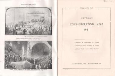
Magazine - LYDIA CHANCELLOR COLLECTION: VICTORIAN COMMEMORATION YEAR - 1951
A magazine titled ' Victorian Commemoration Year-1951.' It is a programme for the Centenary of Government in Victoria, Centenary of Gold Discovery in Victoria and the Jubilee of the Commonwealth of Australia. 11th November, 1950 - 23rd December, 1951. Victoria, J. J. Gourley, Govt. Printer, Melbourne.event, entertainment, centenary, lydia chancellor collection, collection, celebrations, victoria, gold discovery victoria, jubilee, government, australia, history -
 Bendigo Historical Society Inc.
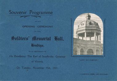
Document - OPENING CEREMONY SOLDIERS' MEMORIAL HALL BENDIGO, 1921
Document: Souvenir Programme of the Opening Ceremony of the Soldiers' Memorial Hall, Bendigo. To be performed by His Exellency, The Earl of Stradbroke, Governor of Victoria. On Tuesday, November 15th, 1921. Cambridge Press, Art Printers.buildings, government, soldiers memorial hall. -
 Bendigo Historical Society Inc.
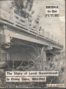
Magazine - HARRY BIGGS COLLECTION: BRIDGE TO THE FUTURE: THE STORY OF LOCAL GOVERNMENT IN OXLEY SHIRE, 1862 - 1962
Magazine. Harry Biggs Collection. Booklet in black & white with a wooden bridge on the cover telling the story of local government in the Oxley Shire, 1862 - 1962. Printer is Despatch Printing. Written by M. A. Moonie.magazine, government, oxley shire, harry biggs collection, bridge to the future: the story of local government in oxley shire, 1862 - 1962 -
 Bendigo Historical Society Inc.
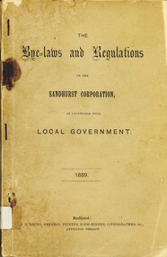
Book - THE BYE LAWS AND REGULATIONS OF THE SANDHURST CORPORATION, 1889
The Bye laws and Regulations of the Sandhurst Corporation. Local Government. 1889 160 pages, J.B.Young General Printer Book Binder Lithographer &c. Brown soft cover. Stapled binding.government, local, bye laws and regulations, bye laws and regulations, sandhurst corporation, bendigo local government -
Clunes Museum
Banner, EVANS BROS PRINTER, BOROUGH OF CLUNES. LOCAL GOVERNMENT ACT 1871. 13TH SCHEDULE
CLUNES COUNCIL, GOVERNMENT ACT 1871LARGE BANNER WITH REGULATIONS AND PROCEEDINGS OF COUNCIL OFFICERS. GOVERNMENT ACT 1871. PRINTED ON FABRIC, COVERED WITH PLASTIC AND MOUNTED ON A WOODEN BATTEN WITH THUMB TACKSclunes council, regulation and proceedings, 13th schedule -
Tatura Irrigation & Wartime Camps Museum
Book, The Argus Guide to Melbourne, before 1967
Soft cover. illustrated. Line drawing city structures, palm tree. 48 pages. melbourne victoria, victorian government tourist bureau -
Tatura Irrigation & Wartime Camps Museum
Box of Maps, early 20th century
... of many house blocks. 17 maps. Box of Maps Government Printers ...Maps are of the following: Toolamba (2), Toolamba West (2), Undera (2), North Murchison, Coomboona (2), Mooroopna, Waranga, Kyabram East, Girgarree East, Mooroopna West (2), Tatura and Goulburn irrigation district (pre 1956).Box containing maps of individual parishes in the county of Rodney, showing early selections. Also one of early Tatura townships with owners of many house blocks. 17 maps.each one is labelled with the parish (Toolamba, Tatura, , etc.) -
 Anglesea and District Historical Society
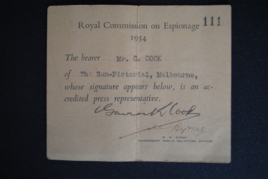
Press Pass, Government Printers, Royal Commission on Espionage, 1954
... Government Printers ...On 13/4/1954 Prime Minister Menzies told parliament of the detection of Vladimir Petrov and his wife Evdokia to Australia from the Soviet Embassy. Menzies established a Royal Commission on Espionage (RCE) to enquire into and report on Soviet espionage in Australia. This item is a "Press Pass" held by Gavin K Cook and issued by M. Brne (Gov.t Public Relatons Officer).ROYAL COMMISSIUON ON ESPIONAGE / No. 111 / 1954 /The bearer 'Mr G Cook" / of "The Sun-Pictorial, Melbourne, / whose signature appears below, is an ac- / credited press representative. / (Signed: M.W. Byrne / Government Public Relations Officer.royal commission on espionage, 1954, gavin cook, sun-pictorial, melbourne, press pass -
 Anglesea and District Historical Society
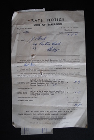
Rate Notice, Government Printers, 1960
... - Thos Goodall. Rate Notice Government Printers ...Rate notice from Shire of Barrabool to Mrs. J. Murch for rates on a boat house due on 10th December 1960. The amount owing is £ 10/-. Attached by staple is the official receipt dated 19.6.61, No. 6449. Signed by Shire Secretary - Thos Goodall.RATE NOTICE / SHIRE OF BARRABOOL / No. 1520 - Property described as Lot... Boat House Anglesea. Attached receipt for £ 10/- . Mrs J. Murch.rates, shire of barrabool, j. murch, anglesea river, boat house, 1961 -
 Melbourne Athenaeum Archives
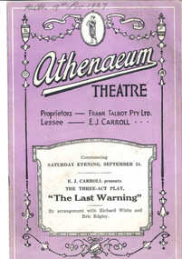
Theatre program, Cass & Clothier (Printers), The Last Warning (play in three acts) by Thomas S Fallon performed at the Athenaeum Theatre in 1927, 1927
The plot of the play is concerned with the performance of a play "The snare" at the imaginary Woodford Theatre; a separate, small paper program for this play within a play is included with the program. The play was based on the novel "House of fear" by Wadsworth Camp and was presented at the Athenaeum Theatre by E.J. Carroll Staged by Eric Edgley (Theatrical family); advertisements show cost of living of the period - two course meal for 2 shillings and 3 pence; holiday suggestions by Government Tourist Bureau are to Mt Buffalo and Gippsland Lakes. Paper program for a play performed at the Athenaeum Theatre Saturday September 24 1927; coloured cover; 16 p. includes articles about the film, the actors and advertisementsathenaeum theatre, program, programme, the last warning, e j carroll, richard white, eric edgley, frank talbot pty ltd, thomas f fallon -
Clunes Museum
Book, ARNALL , JACKSON PRINTERS & PUBLISHERS 428 COLLINS STREET, LOCAL GOVERNMENT ACT 1928 WITH INDEX AND AMENDMENTS, 1931
THIS BOOK CONTAINS LOCAL LAW ACT 1928GREEN HARD COVERED BOOK ON LOCAL LAW ACT 1928, CONTAINING 358 PAGES.non-fictionTHIS BOOK CONTAINS LOCAL LAW ACT 1928local history, government, local government council, government - local -
Clunes Museum
Document - BOOK, ARNALL & JACKSON, PRINTERS, PUBLISHERS & LAW STATIONERS, THE MANUAL OF LOCAL GOVERNMENT LAW AND MUNICIPAL GUIDE, 1891
MANUAL OF LOCAL GOVERNMENT LAW AND MUNICIPAL GUIDE BY ALFRED MAC HUGH, M.A, DUBLIN UNIVERSITY, USED BY THE TOWN CLERK OF BOROUGH OF CLUNES.BOOK, BLACK, LEATHERETTE BINDING, GOLD LETTERINGTHE MANUAL OF LOCAL GOVERNMENT LAW AND MUNICIPAL GUIDE. TOWN CLERK BOROUGH OF CLUNESlocal history, book, reference, government, local -
Koorie Heritage Trust
Book, C. E. Sayers (Original edition edited by Bride, Thomas Francis), Letters from Victorian pioneers : a series of papers on the early occupation of the colony, the Aborigines, etc. addressed by Victorian pioneers to His Excellency Charles Joseph La Trobe, Esq., Lieutenant-Governor of the Colony of Victoria, 1983
... : Heinemann, 1969. Originally published: Melbourne : Government ...Brief notes on the contributors and incidents have been included in this edition although the above-mentioned items have been left out, some marginal notes made by Governor La Trobe have been dealt with in the footnotes. "From the original edition edited for the Trustees of the Public Library by Thomas Francis Bride'. Previously published: Melbourne : Heinemann, 1969. Originally published: Melbourne : Government Printer for the Trustees of the Public Library, Museums and National Gallery of Victoria, 1898.xiv, 455 p., 31 p. of plates : map ; 26 cm.Brief notes on the contributors and incidents have been included in this edition although the above-mentioned items have been left out, some marginal notes made by Governor La Trobe have been dealt with in the footnotes. "From the original edition edited for the Trustees of the Public Library by Thomas Francis Bride'. Previously published: Melbourne : Heinemann, 1969. Originally published: Melbourne : Government Printer for the Trustees of the Public Library, Museums and National Gallery of Victoria, 1898.pioneering, 1836-1854. victoria. correspondence, diaries, etc. | victoria. description & travel, 1836-1854. correspondence, diaries, etc. | frontier and pioneer life -- victoria. | victoria -- history -- 1834-1900 -- sources. | victoria -- description and travel -- 1851-1900. -
 Ballarat Tramway Museum
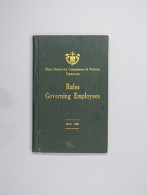
Book, State Electricity Commission of Victoria (SECV), "Rules Governing Employees", May 1936, 1943
Gives details with an index of the rules for Motorman, Conductors and both types of employees together. Has an "Issued to" form inside the front cover - no entries. Has printer details on inside title sheet and on rear sheet and print stock details "FTY 18-8,-6475 on inside front only." 3068.1 - As above, but printed in 1943 - FTY 18-8.F1927/43. On inside of front cover has a list of Route Numbers for Ballarat - see image 2, and marked as issued to R. Courtney. The government printed H.E. Daw. Added 19/1/2007. See Reg. 1260 for March 1948 version and 9534 for another versions with By-Law 1 inserted as part of the item with a 1940 date. See btm8078.4 for another copy.Demonstrates aspects of the way the SEC issued rules to employees on how they should behave and perform their duties safely. Yields information on particular items and operations. Also yields information on a route number system, not generally used for the public.Booklet with green cloth covers, titled in gold block "State Electricity Commission of Victoria - Tramways - Rules Governing Employees - May 1936"on heavy card with inside paper covers on heavy paper and 24 pages printed both sides, with stitched pages with white cotton. 3068 - On outside cover and inside cover sheet "Accountant" in ink., 3068.1 - On top of first page - "R. Courtney".trams, tramways, secv rules, rules, motormen, conductors -
 Bendigo Historical Society Inc.
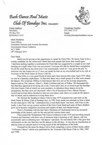
Document - PETER ELLIS COLLECTION: LETTER BUSH DANCE AND MUSIC CLUB BENDIGO, 28th February 2011
3 Page Letter printed on A4 printer paper. Bearing the letterhead of the Bush Dance and Music Club of Bendigo Inc. Postal Address Secretary PO Box 922 Bendigo 3552 Telephone number (03) 5442 1153 email [email protected] Mark Maddock Case Officer Australian Honours and Awards Secretariat Government house Canberra ACT 2600 28th February 2011. Dear Mark, Thank you for giving us the opportunity to speak for Peter Ellis. We know Peter to be a worthy candidate for the award and I think that most people that know him would agree. I had been putting together a nomination for Peter that was suggested by a couple at our club meeting on a night when Peter was not present. Everyone felt that he should have recognition for all the work that he has done and it was unanimously voted on. I was given the job. As someone else has beaten me to it I now can speak for him on my own behalf and in my role as secretary of the Bush Dance & Music Club Inc. Peter Ellis is a very good friend of mine and I have known him since April 1975 when we met at a Saturday night dance. At that time there was a small group of us that went around the dances. We would go 100kms to find dances that were not on the average programme, dances such as The Lancers, Albert's, Waltz Cotillion and lots of Polkas. We bemoaned the fact that they appeared to be dying out in the Towns and Cities so we tried to get the Bendigo Old Time Dance Club of which we were members, to introduce these dances on to the programme, but they were not interested. After a lot of discussion Peter, Maurie Rayner, myself and several others decided to start our own dance club where we could do the dances that we liked, and to endeavour to keep them alive. We formed the Sandhurst Dance Club in June 1979 (renamed ten years later as the Bush Dance & Music Club of Bendigo Inc.) In 1981 Peter made two attempts to form a band for the club and in 1983 the 'Celebrated Emu Creek Bush Band' was born, with Peter as the leader. Later Peter set up a junior section of the Emu Creek Band and some of these children grew up to become competent musicians and leaders of their own bands/Groups. Peter's friendship with the late Harry McQueen of Castlemaine led to and increased knowledge of the dances, calls for the sets and the various tunes used. Peter joined the Wedderburn Old Timers Orchestra in late 1979 and travelling around Victoria and interstate with them was of immense help in learning to MC dances, call sets acoustically and in collecting new 'old dances' and tunes. He met elderly MC's who gave him information on the way that they ran the dances in the old days. It was also an introduction to playing items at concerts and in reviving much of the old traditions of the bush. Demand for the tunes for dances led to Peter compiling a series of three books called 'Collectors Choice' which were published by the Victorian Folk Music Club in 1986, 1987 and 1988. 1988 was a very busy year for Peter and The Emu Creek Bush Band as they recorded two double music tapes for the club 'The Merry Country Dance' and 'The Waltz the Polka and all Kinds of Dancing' which were in much demand at the time. Also in 1988 he collaborated with the late Shirley Andrews and they co-authored the book 'Two Hundred Dancing Years and how to celebrate them with a Colonial Ball' for the Bicentennial of 1988. this publication, was instigated by the Government backed Bicentenary Committee, and distributed free to every municipality in Australia. In 1996 The Emu Creek Bush Band and Peter recorded and produced a single CD called a Friday night at 'The Spring Valley Hop'. In 1998 The Bush Dance & Music Club again happily agreed to financially back Peter to produce a series of CDs. The first thing he did was to revive and update the 1988 music tapes for CD. The first of the Qadrille Mania series of double CDs with companion call books was launched in 1999 then in 2000 and 2001. then the triple CD called The Waltz Polka & all kinds of Dances in 2002 followed by the Merry Country Dance CDs in 2005, 2006 and 2007. There were six double CDs and one triple CD produced which was a major undertaking that went on for eight years. The CDs have a great many tunes that Peter collected over the years mixed in with well known tunes and there are very few repeats. During this time we applied for a Grant from the Victorian Government to publish a book on the social History of country dances and dance instructions with Peter as the author. We were successful and published it in 2005. Our CDs and book have all been lodged with the National Library of Canberra as has all Peter's sheet music, boxes of it, as well as everything he has produced. At the 2005 Canberra National Folk Festival, at a meeting of collectors, it was stated that Peter has the largest collection of dance related material in the National Library. Peter compiled and produced his own project a triple CD called 'Take Me Back to Bendigo' in 2002. 2006 Peter and Emu Creek Bush Band produced another single CD 'Bush Concert Vol one Back to Goornong'. 2008 A pet project of Peter's was compiling and producing a double CD for the Wedderburn Old Timers it was of all the recorded material performed by them at concerts and taped by friends and fans. It was funded by Gavan Holt a son of the late Lindsay Holt an original 'Old Timer'. Recent publications are a book mainly music 'Music Makes Me Smile' a tribute to Con Klippel and the music of the Nariel Valley near Corryong Victoria. Peter Ellis & Harry Gardner 1998. The Waltz, The Polka & All Kinds of Dancing' a sheet music book for musicians supported by the Folk Song & Dance Society of Victoria. 2007-8 not sure of year. Peter has been involved over the years in collecting music and dance by himself and also with Rob Willis and the late John Meredith for the National Library in Canberra. He is continually asked for information and to write articles for people and to verify points re dance and music. He corresponds with like minded people overseas and frequently goes off to Folk Festivals all over the country, usually running dance classes, musician's workshops or just playing for dances. He is an excellent musician and plays Piano, Button Accordion, Concertina, Mouth Organ, Tin Whistle, Ukulele, Spoons and the Bones. He is regarded as one of Australia's foremost collectors and presenters of Australian traditional dance tunes, dances and some musical instruments. Over the years I have heard him referred to as the Guru of folk dance and music. Peter lives and breathes for this passion of his and always has several irons in the fire. He is a life member of The Bush Dance & Music Club of Bendigo Inc. The Victorian Folk Music Club, and The Bendigo Field Naturalists Club. He was a recipient of the David Squance Award in 1994 presented by the Folk Song & Dance Society of Victoria. Over the last twelve months for the folk magazine 'Trad & Now' he has written articles on the old dances and music and this is an ongoing project. This has led to our clubs present project which is the filming of the dances to be shown on UTube as it is referred to in the magazine. This involves members in hours and hours of practising the dances then filming them, and all with Peter's expert teaching and watchful eye on everyone. The Bush Dance & Music Club are and always have been behind Peter wholeheartedly in everything that he does and we are extremely proud of what he has achieved. His drive and enthusiasm for the preservation of music and dance is catching. People like Peter are absolutely necessary in finding and preserving our Australian Heritage, without them it would be lost forever and Australia would be a great deal poorer for it. The Bush Dance and Music Club of Bendigo Inc. and I fully support this nomination for an award as he is truly deserving of it. Yours sincerely Mary E Smith. Secretary of the Bush Dance & Music Club Inc. Peter's Timeline. 1979 A Foundation Member of the Bush Dance & Music Club of Bendigo Inc. 1979 Joined the Wedderburn Old Timers Orchestra. 1983 The Celebrated Emu Creek Bush Band was formed. 1986 Collectors Choice. Volume one. 1987 Collectors Choice. Volume Two. 1988 Collectors Choice. Volume Three. 1988 Recorded Tapes - The Merry Country Dance & The Waltz Polka & all Kinds of Dances. 1988 A book with the late Shirley Andrews called Two Hundred years of Dancing. 1991 Across to Perth collecting for National Library with the Late John Meredith. 1996 Single CD A Friday Night at the Spring Gully Hop. 1998 Music Makes Me Smile. A tribute to Con Klippel 7 music of the Nariel Valley. 1999 Double CD Quadrille Mania 1&2 2000 Double CD Quadrille Mania 3&4 2001 Double CD Quadrille Mania 5&6 2002 His own project triple CD Take Me Back To Bendigo. (Goldrush to Federation and Beyond). 2002 Triple CD The Waltz The Polka & All kinds of Dances. 2005 Double CD The Merry Country Dance 1 & 2. 2002 Book, The Merry Country Dance. 2006 Single CD with Emu Creek 'Bush Concert Vol 1 Back to Goornong' 2006 Double CD The Merry Country Dance 3&4 2007 Double CD The Merry Country Dance 5&6 2007-8-? A book of music, The Waltz, The Polka & All Kinds of Dances. 2008 Double CD The Wedderburn Old Timers in Concert.person, individual, peter ellis oam -
 Bendigo Historical Society Inc.
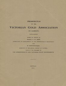
Document - MCCOLL, RANKIN AND STANISTREET COLLECTION: VICTORIAN GOLD ASSOCIATION, 1931
Prospectus of the Victorian Gold Association N.L. Based on a report by Messrs H. W. Gepp Consultant on Development to the Commonwealth Government and W. Baragwanath, Director of the Geological Survey of Victoria. Dated 1931 This company was formed to investigate the Deborah Mine, The Central Nell Gwynne Mine and the Monument Hill Mine. 12 pages including maps and Transverse Sections of the MinesThe Commonwealth and Victorian State Governments. E. Whitehead & Co., Pty., Ltd Printers 21 Equitale Place, Melbourne, C1.gold, mining, prospectus, bendigo, gold mines, victorian gold associatian, deborah mine, central nell gwynne mine, monument hill mine. -
 Bendigo Historical Society Inc.
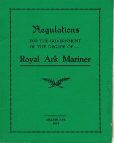
Book - LODGE COLLECTION: BOOK. REGUALTIONS FOR THE GOVERNMENT OF THE DEGREE OF ROYAL ARK MARINER
Lodge book. Regulations for the government of the degree of Royal Ark mariner.G.A. Sharman, Printer, 13 Wrights Lane Melbourneclubs, social, regulations royal ark mariner -
 Bendigo Historical Society Inc.
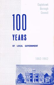
Book - RANDALL COLLECTION: 100 YEARS OF LOCAL GOVERNMENT, EAGLEHAWK BOROUGH COUNCIL 1862 - 1962, 1862 - 1962
Book, 100 Years Of Local Government, Eaglehawk Borough Council 1862 - 1962.Bolton Bros. Pty.Ltd. Printers, Bendigobook, bendigo, eaglehawk 100 years -
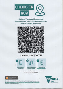 Ballarat Tramway Museum
Administrative record - BTM QR Code check in sheet, Services Victoria, 2021
QR Code check in sheet during the COVID-19 pandemic event used to check members and visitors into the Museum. Used during 2021 and 2022. Produced by the Victorian State Government Services Victoria unit. The system recorded the entry of visitors to the museum, date and time.Demonstrates the systems that State Government required visitors to check in using their mobile devices and a detailed QR code.Laminated A4 sheet, printed with a colour laser printer.btm, covid-19, services victoria -
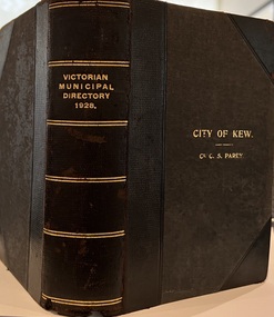 Kew Historical Society Inc
Journal, Arnall & Jackson: Printers & Stationers, Victorian Municipal Directory and Gazetteer : Also Commonwealth Guide and the Water Supply Record for 1928
The Victorian Municipal Directory provided annual details, and later bi-annual details, of all councils. Published by Arnall & Jackson (Printers and Stationers), copies were published in 'cloth' for sixteen shillings and 'half roan' for eighteen shillings. This copy was owned by Cr C.S.Parry. Elected to the Kew City Council as a representative of North Ward, Cr Parry was elevated to the position of Mayor in 1931. It, together with five other editions, was presented to the Kew Historical Society in 1987 by his grandson.Bound copy of the Victorian Municipal Directory and Gazetteer: Also Commonwealth Guide and the Water Supply Record for 1928. The volume contains 846 pages and includes sections on: - Comparative table – Municipal Returns for Twenty-one Years. - Index to Townships, Parishes and Railway Stations. - Changes and appointments. - Commonwealth of Australia (Constitution, Parliament, Departments and Officers). - State of Victoria (Parliament, Departments and Officers / Boards, Institutions, Trusts and Loans). - Municipalities in Victoria (Cities and Towns, Boroughs, Shires). - Water Supply (State Rivers and Water Supply Commission).non-fictionThe Victorian Municipal Directory provided annual details, and later bi-annual details, of all councils. Published by Arnall & Jackson (Printers and Stationers), copies were published in 'cloth' for sixteen shillings and 'half roan' for eighteen shillings. This copy was owned by Cr C.S.Parry. Elected to the Kew City Council as a representative of North Ward, Cr Parry was elevated to the position of Mayor in 1931. It, together with five other editions, was presented to the Kew Historical Society in 1987 by his grandson. victoria -- registers -- periodicals., victoria -- directories., water-supply -- victoria -- directories., municipal government -- victoria -- periodicals., cities and towns -- victoria -- directories. -
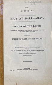 Kew Historical Society Inc
Document, Riot at Ballaarat : report of the Board of Enquiry appointed to enquire into circumstances connected with the late disturbance at Ballaarat ; together with The evidence taken by the Board, 1854
Parliamentary paper (Victoria. Parliament) ; 1854, A. no. 27. "Laid upon the Council table by the Colonial Secretary...and ordered to be printed 21st November, 1854." At head of title: 1854 Victoria. Chairman: Sturt, E.P.S. Cover title. No. 1 of 15 entitled : [Eureka Stockade : a series of 15 reports on the riot at Ballaarat.Melbourne : John Ferres, Govt. Printer, 1854 xv, 22 p. ; 35 cm.non-fictionParliamentary paper (Victoria. Parliament) ; 1854, A. no. 27. "Laid upon the Council table by the Colonial Secretary...and ordered to be printed 21st November, 1854." At head of title: 1854 Victoria. Chairman: Sturt, E.P.S. Cover title. No. 1 of 15 entitled : [Eureka Stockade : a series of 15 reports on the riot at Ballaarat. eureka stockade, ballarat, vic., 1854 -- history -- sources, gold mines and mining -- victoria -- ballarat -- history -- sources, ballarat (vic.) -- history -- sources, victoria -- history -- 1851-1891 -- sources -
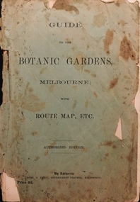 Kew Historical Society Inc
Booklet, Robert S Brain, Guide to the Botanic Gardens Melbourne, with Route Map etc, 1901
... , Melbourne published by the Government Printer, Victoria. Includes ...Authorised guide to the Botanic Gardens, Melbourne published by the Government Printer, Victoria. Includes three fold out pages, the first a panoramic photograph, the second a colour map of the Botanic Gardens in 1873 upon the retirement of Baron Von Mueller from the Directorship in 1873 and the third a map of the Botanic Gardens in 1901 showing alterations and improvements since 1873 by W.R. Guilfoyle, Director..Melbourne : Robt. S. Brain, Govt. Printer, [1901] 19 p., [3] folded leaves of plates : ill., plans ; 21 cm. non-fictionAuthorised guide to the Botanic Gardens, Melbourne published by the Government Printer, Victoria. Includes three fold out pages, the first a panoramic photograph, the second a colour map of the Botanic Gardens in 1873 upon the retirement of Baron Von Mueller from the Directorship in 1873 and the third a map of the Botanic Gardens in 1901 showing alterations and improvements since 1873 by W.R. Guilfoyle, Director..botanic gardens -- melbourne (vic.), christian-washfold collection -
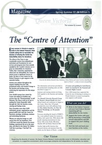 Queen Victoria Women's Centre
Newsletter, Q Magazine: The "Centre of Attention", c. November 1997
The newsletter was attempting to reach out to the stakeholders and friends to ask the Australian Government to grant the centre tax destructibility status. Launch of Emily's list in the centre. Monash University Research Group for Women's Mental Health launch at the centre.A4 Printer paper. 8 pages. Navy and taupe on white. Grey scaled images throughout.cultural structures and establishments, newsletter, historical site, fundraising -
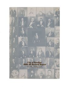 City of Greater Bendigo - Civic Collection
Financial record - Mayoral Report, City of Bendigo, 1990
Financial and civic report.A4 size Mayoral report including Councillor and Executive officer information, organisational structure, economic development, planning, family and leisure services. No mention of arts or cultural services. non-fictionFinancial and civic report.mayor morley, mayoress morley, councillor p. r. morley -
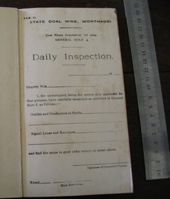 Parks Victoria - State Coal Mine - Wonthaggi
Booklet, Government Printers, "Daily Inspection", C 1960's
... Inspection" Booklet Government Printers ...Booklet of "Daily Inspection" report sheets, serrated edge. Green cardboard cover, stapled spine covered in grey binding tape. -
 Melbourne Tram Museum
Pamphlet, Fiona Richardson MP, "No extra tram services", c2011/12
Pamphlet - DL size, double sided, colour on light card titled "No Extra train Services, No new trams, no new buses 30.5 million extra passengers" with an image of a Comeng train behind. Issued by Fiona Richardson MP Shadow Minister for Transport, at the time of the Baillieu Liberal Government in Victoria - c2011/12 Gives details of the person who authorised the pamphlet, the printer, and that there has no new train services, or trams or buses to carry a growing passenger number.trams, tramways, melbourne, public transport, labor party, new trams, liberal party