Showing 3660 items
matching landscaping
-
 Greensborough Historical Society
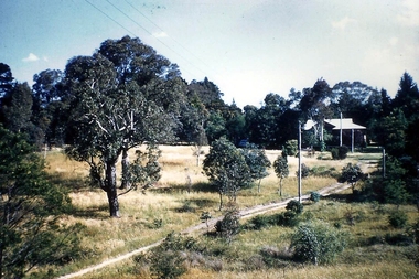
Photograph - Digital image, Landscape, possibly Greensborough, 1930c
Photograph of unidentified landscape, possibly Greensborough. From the Yandell collection.Digital copy of colour photograph.greensborough -
 City of Ballarat Libraries
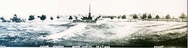
Photograph - Card Box Photographs, Eureka Memorial, Ballarat 1903
Panorama view of the Eureka Memorial. The garden has yet to be landscaped.eureka memorial, gardens, public -
 Phillip Island and District Historical Society Inc.
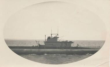
Photograph, Submarine in Westernport, c. 1940
Part of a collection from Jessie Smith of Phillip Island events and landscapes.Submarine J.3 at sea - close up in Westernport.local history, photographs, military history, navy, naval submarine, cowes jetty, phillip island, black & white photograph, wwii, jessie smith collection, stan mcfee -
 Peterborough History Group
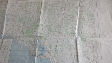
Map - Government map, Government Printer, Port campbell, 1957
Aerial survey map showing roads, vegetation and other landscape features.Significant because it shows the detail of the region in 1957Original 1957 State Aerial Survey Map of Port Campbell region, including Peterboroughpeterborough, aerial survey map, maps, port campell -
 Stawell Historical Society Inc
Map - Plan, Earle and Partners, Restoration of Pleasant Creek Courthouse Stawell West 1974, 24/10/1974
Drawing 1 Is not in Collection Drawing 5 Landscape Pal is 5092-13 A2 Sheets. Drawing 3 is Elevations. Drawing 2 is Gallery And Roof Plan. Drawing 4 Details24 Oct 74. And 25 Oct 74stawell historical -
Ringwood and District Historical Society
Souvenir programmes, City of Ringwood Souvenir Programme, Nostalgia Night, 25 November 1988, 1988
Devised by the Ringwood Bicentennial Community Committee. Used to celebrate the bicentenary 1788 - 1988 and also book launch by Miss La Scala, State Librarian of 'Place of Many Eagles' by Hugh Anderson in the Convention centre, Ringwood on 25 November, 1988.Trifold landscape cardboard programmes with brown printing, pink coloured, 2 copies. +Additional Keywords: La Scala, Jane (State Librarian) / Anderson, Hugh (Author)Souvenir Programmes, Nostalgia Night, 25 November 1988 -
 Ringwood and District Historical Society
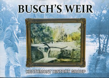
Book, PenFolk Publishing, Busch's Weir, 2019
One of several Dandenong Creek marker posts inscriptions: "Busch's Weir was located at this section of the creek between 1930s to 1960s. In the 1930s, German migrant Hermann Otto Busch and his wife Dorothea moved to Bayswater and opened the Waldheim Farm Guest House. Busch built a concrete weir to create a popular swimming and fishing destination. The weir was a thriving attraction until the 1960s. Although little remains, it is fondly remembered by the Heathmont community. City dwellers would retreat to the guesthouse and wander down to Dandenong Creek to enjoy a weekend in the 'country'. Busch's guest house, tea rooms, and weir attracted locals and tourists alike."A private weir on Dandenong Creek Bayswater and Heathmont, 1930s-1967. Landscape layout soft covered book by Heathmont History Group (Ringwood & District Historical Society.Front cover image: A 1956 painting by Hermann Busch of his weir. The publication of this book has been made possible by a financial grant from Melbourne Water, as part of the Enhancing Our Dandenong Creek program. We particularly acknowledge the encouragement and support of Sarah Watkins, Senior Planning Engineer, MW. -
 Bendigo Military Museum
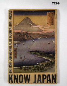
Book - BOOK, BCOF, The Rodney Press, "KNOW JAPAN", C.1946
Purpose of the book was to provide members with some background to an understanding of the Japanese People to help the fit into the democratic world. Item in the collection of Richard William McGILVERY, RAAF. refer Cat No. 7287P for his service details, photos and awards.Cover - yellow/ orange colour - book of 96 pages. Title on front with picture of landscape of a bay with some ships and mountain in background in various pale pastel colours.Title of book "KNOW JAPAN"/ On side " BRITISH COMMONWEALTH OCCUPATIONAL FORCES" Inside back cover is some pencil notations and numbers. bcof, book, history, richard william mcgilvery -
 Phillip Island and District Historical Society Inc.
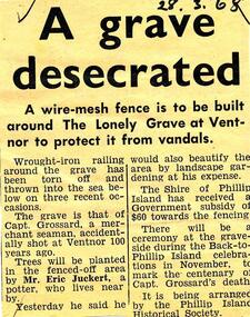
Newspaper clippings, 28/03/1968
Collection of newspaper clippers in scrap book dated 1960 - 1973Newspaper article concerning the grave of Captain Grossard at Ventnor; desecration; fence to be built; landscape works; proposed ceremony November 1968 to coincide with "Back to Phillip Island"."A grave desecrated"local history, newspapers, protection for "lonely grave" at ventnor, phillip island, captain grossard, captain grossard's grave, jean jamieson -
 Glen Eira Historical Society
Album - Album page, Hotham Street, Circa 1972
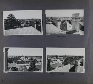
This photograph is part of the Caulfield Historical Album 1972. This album was created in approximately 1972 as part of a project by the Caulfield Historical Society to assist in identifying buildings worthy of preservation. The album is related to a Survey the Caulfield Historical Society developed in collaboration with the National Trust of Australia (Victoria) and Caulfield City Council to identify historic buildings within the City of Caulfield that warranted the protection of a National Trust Classification. Principal photographer thought to be Trevor Hart, member of Caulfield Historical Society. Most photographs were taken between 1966-1972 with a small number of photographs being older and from unknown sources. All photographs are black and white except where stated, with 386 photographs over 198 pages.Victorian Heritage Database - Hotham Street Road Overbridge HO116 Heritage Overlay - City of Glen Eira https://vhd.heritagecouncil.vic.gov.au/places/43557 (as of 04/07/2021) The Hotham Street road overbridge is located on the Sandringham railway line between Ripponlea and Elsternwick railway stations. It is presumed to have been built by contractors Sharp and Campbell who signed a contract on 25th . November, 1881 to construct a second line of railway between Windsor and Elsternwick. This contract was completed during 1882 and the bridge may have been designed in the year when Robert Watson took over from William Elsdon as engineer in chief for the Victorian railways. It is historically, aesthetically and technically significant. It is historically significant (Criterion A) to the extent that it demonstrates the standards of construction adopted by the Victorian Railways Department when it rebuilt the lines acquired from the private railway companies, (compare the Geelong and Melbourne Railway Co's line from Newport to Geelong, acquired in 1860). It is aesthetically significant (Criterion E) as an intact nineteenth century structure of its type, many similar girder bridges having been renewed with concrete girders in recent years. The bluestone abutments demonstrate high standards of stone masonry and are representative of Departmental work of the period. This bridge forms one of a group of historic structures on the railway to Brighton Beach and therefore contributes to the line's cultural importance as a whole. The survival of the riveted iron girders with their bellied angle iron struts is important since these elements are representative of the civil engineering practices of the Victorian Railways at the time and constitute the technical significance (Criterion F) of the structure.Page 96 of Photograph Album with three photographs (one portrait and two landscape) from Hotham Street - two external views of one house and a railway bridge.Handwritten: Hotham Street [top right] / 112 HOTHAM ST [under top left photo] / BRIDGE OVER SANDRINGHAM RAILWAY [under top right photo] / 112 HOTHAM ST CNR MELBY AVE [under bottom left photo] / 96 [bottom right]trevor hart, elsternwick, hotham street, caulfield, houses, brick, bay windows, verandahs, railway bridges, tunnels, gardens, bluestone, civil engineering, victorian railways, sharp and campbell, contractors -
 Glen Eira Historical Society
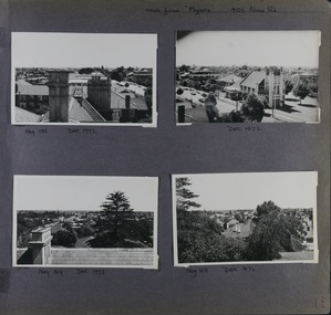
Album - Album page, Myoora, 405 Alma Road, Circa 1972
This photograph is part of the Caulfield Historical Album 1972. This album was created in approximately 1972 as part of a project by the Caulfield Historical Society to assist in identifying buildings worthy of preservation. The album is related to a Survey the Caulfield Historical Society developed in collaboration with the National Trust of Australia (Victoria) and Caulfield City Council to identify historic buildings within the City of Caulfield that warranted the protection of a National Trust Classification. Principal photographer thought to be Trevor Hart, member of Caulfield Historical Society. Most photographs were taken between 1966-1972 with a small number of photographs being older and from unknown sources. All photographs are black and white except where stated, with 386 photographs over 198 pages.Victorian Heritage Register (VHR) Number H0490 From the Victorian Heritage Register Database - Citation for Myoora https://vhd.heritagecouncil.vic.gov.au/places/275 (as at 6/10/2020) Myoora, 405 Alma Road, North Caulfield, was designed by Reed, Henderson & Smart and can be attributed to Anketell Henderson. It was built in 1886 and 1887 for Thomas Christian, who had founded the fabled gold mine, the Day Dawn at Charters Towers. He never occupied the house although his widow lived there for some time. The house was subdivided into three and later six flats. Myoora was one of many large mansions on broad acres with gardens in Caulfield. Perhaps the grandest was Labassa. The mansions date from the 1850s through to the late 1890s. The siting of Myoora on a ridge influenced its planning and composition. A central hall and corridor along the ridge is entered from the centre of the more formal north facade. The entrance is marked by an elaborately detailed tower. A stair turret provides a second accent. The western end of the building is completed by a massively detailed chimney as the service wing. The south facade enjoyed an outlook to port phillip from a two-storey cast iron verandah. Bay windows, chimneys, the tower and the turret and minor details are brought together in a sophisticated asymmetrical composition. This is reflected in the planning. The asymmetry of Myoora pivoting on the tower is the most notable feature of the building. The walls are built of cement rendered brick. The cement render has not been painted. The roof is slate. The balconies and verandah are cast iron. The footings and cellar are bluestone. The architectural firm Reed, Henderson & Smart was very prominent in Victoria in the nineteenth century. Anketell Henderson was an eminent and well respected member of the profession. He worked successfully in London and interstate as well as in Victoria. They were better known for commercial and public buildings. Myoora is an important private commission. The style of Myoora is a combination of details from the Continental and English Renaissance through the boom style and the Queen Anne style. There is also an early influence from the American Romanesque style especially in the stair turret. The latter style was important at the turn of the century and Myoora is a significant precursor. Other buildings of a similar scale survive in Caulfield and elsewhere. Labassa, the most fabulous, is quite different stylistically as are most of the other comparable mansions. Stonnington is perhaps closer but relies on different details from the Queen Anne style and lacks any American influence. For its historical associations through its owners and architects, for its style and composition and for its intactness, Myoora is significant at a State level. The craftmanship of Myoora is what could be expected of a building of the time and type. It is relatively intact and in fair condition. The main staircase has been removed, minor alterations to decorative features have occurred and additions have been made to the exterior.Page 17 of Photograph Album including four black and white photographs. All are arranged in landscape orientation with two on the top half of the page and the other two below.Handwritten: Neg 185 Dec 1972 [under top left photo] / Dec 1972 [under top right photo] / Dec 1972 [under bottom left photo] / Neg 153 Dec 1972 [under bottom right photo] / 17 [bottom left]caulfield north, trevor hart, alma road, mansion, myoora, tower, thomas christian, 1880's, queen anne, cement rendered brick, unpainted, balconies, verandahs, anketell henderson, continental and english renaissance, american romanesque, cast iron balconies, panoramic views, streetscapes, cast iron work, reed henderson & smart, gardens, asymmetrical style, slate roofs -
 Glen Eira Historical Society
Album - Album page, Myoora, 405 Alma Road, Circa 1972
This photograph is part of the Caulfield Historical Album 1972. This album was created in approximately 1972 as part of a project by the Caulfield Historical Society to assist in identifying buildings worthy of preservation. The album is related to a Survey the Caulfield Historical Society developed in collaboration with the National Trust of Australia (Victoria) and Caulfield City Council to identify historic buildings within the City of Caulfield that warranted the protection of a National Trust Classification. Principal photographer thought to be Trevor Hart, member of Caulfield Historical Society. Most photographs were taken between 1966-1972 with a small number of photographs being older and from unknown sources. All photographs are black and white except where stated, with 386 photographs over 198 pages.Victorian Heritage Register (VHR) Number H0490 From the Victorian Heritage Register Database - Citation for Myoora https://vhd.heritagecouncil.vic.gov.au/places/275 (as at 6/10/2020) Myoora, 405 Alma Road, North Caulfield, was designed by Reed, Henderson & Smart and can be attributed to Anketell Henderson. It was built in 1886 and 1887 for Thomas Christian, who had founded the fabled gold mine, the Day Dawn at Charters Towers. He never occupied the house although his widow lived there for some time. The house was subdivided into three and later six flats. Myoora was one of many large mansions on broad acres with gardens in Caulfield. Perhaps the grandest was Labassa. The mansions date from the 1850s through to the late 1890s. The siting of Myoora on a ridge influenced its planning and composition. A central hall and corridor along the ridge is entered from the centre of the more formal north facade. The entrance is marked by an elaborately detailed tower. A stair turret provides a second accent. The western end of the building is completed by a massively detailed chimney as the service wing. The south facade enjoyed an outlook to port phillip from a two-storey cast iron verandah. Bay windows, chimneys, the tower and the turret and minor details are brought together in a sophisticated asymmetrical composition. This is reflected in the planning. The asymmetry of Myoora pivoting on the tower is the most notable feature of the building. The walls are built of cement rendered brick. The cement render has not been painted. The roof is slate. The balconies and verandah are cast iron. The footings and cellar are bluestone. The architectural firm Reed, Henderson & Smart was very prominent in Victoria in the nineteenth century. Anketell Henderson was an eminent and well respected member of the profession. He worked successfully in London and interstate as well as in Victoria. They were better known for commercial and public buildings. Myoora is an important private commission. The style of Myoora is a combination of details from the Continental and English Renaissance through the boom style and the Queen Anne style. There is also an early influence from the American Romanesque style especially in the stair turret. The latter style was important at the turn of the century and Myoora is a significant precursor. Other buildings of a similar scale survive in Caulfield and elsewhere. Labassa, the most fabulous, is quite different stylistically as are most of the other comparable mansions. Stonnington is perhaps closer but relies on different details from the Queen Anne style and lacks any American influence. For its historical associations through its owners and architects, for its style and composition and for its intactness, Myoora is significant at a State level. The craftmanship of Myoora is what could be expected of a building of the time and type. It is relatively intact and in fair condition. The main staircase has been removed, minor alterations to decorative features have occurred and additions have been made to the exterior.Page 18 of Photograph Album including four black and white photographs. All are arranged in landscape orientation with two on the top half of the page and the other two below.Handwritten: views from "Myoora" 405 Alma Road / [top right hand] / Neg 188 Dec 1972 [under top left photo] / Dec 1972 [under top right photo] / Neg 184 Dec 1972 [under bottom left photo] / Neg 168 Dec 1972 [under bottom right photo] / 18 [bottom right]caulfield north, trevor hart, alma road, mansion, myoora, tower, thomas christian, 1880's, queen anne, turret, cement rendered brick, unpainted, balconies, verandahs, anketell henderson, continental and english renaissance, american romanesque, cast iron balconies, panoramic views, streetscapes, cast iron work, reed henderson & smart, asymmetrical style, gardens, slate roofs -
 Glen Eira Historical Society
Album - Album page, St Mary's Church Hall, Glen Eira Road, Circa 1972
This photograph is part of the Caulfield Historical Album 1972. This album was created in approximately 1972 as part of a project by the Caulfield Historical Society to assist in identifying buildings worthy of preservation. The album is related to a Survey the Caulfield Historical Society developed in collaboration with the National Trust of Australia (Victoria) and Caulfield City Council to identify historic buildings within the City of Caulfield that warranted the protection of a National Trust Classification. Principal photographer thought to be Trevor Hart, member of Caulfield Historical Society. Most photographs were taken between 1966-1972 with a small number of photographs being older and from unknown sources. All photographs are black and white except where stated, with 386 photographs over 198 pages. The Jubilee School on the corner of Hood Crescent and Glen Eira Road was built in 1887 AD to commemorate Queen Victoria’s Jubilee.Victorian Heritage Database https://vhd.heritagecouncil.vic.gov.au/places/43705 The former St Mary's Jubilee School is locally significant as an early purpose built church school, associated with St Mary's Church. Its use of polychrome brick is locally conspicuous whilst the adoption of the Gothic Style not only underlines its Christian foundations but relates to the comparable schools of the Public Works Department of the same period.Page 57 of Photograph Album with four exterior photographs (2 portrait and 2 landscape) of St Mary's Church Hall. Bottom right photograph is a photo of a photo.Hand written: St Mary's Church Hall - Glen Eira Road [top left] / Neg 233 8 Oct 1966 [under top left photo] / 3 Sept 1972 [under bottom left photo] / bottom right photo titled "St Mary's Sunday School" / 57 [bottom left] trevor hart, 1880's, elsternwick, glen eira road, st kilda east, church of england, st mary's, caulfield north, st mary's anglican church hall, hood crescent, jubilee school, polychrome brickwork, curved windows, church hall, queen victoria’s jubilee, victorian, sunday schools, st mary's jubilee school, gothic style -
 Glen Eira Historical Society
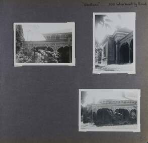
Album - Album page, Glentana, Glen Huntly Road, 805, Circa 1972
This photograph is part of the Caulfield Historical Album 1972. This album was created in approximately 1972 as part of a project by the Caulfield Historical Society to assist in identifying buildings worthy of preservation. The album is related to a Survey the Caulfield Historical Society developed in collaboration with the National Trust of Australia (Victoria) and Caulfield City Council to identify historic buildings within the City of Caulfield that warranted the protection of a National Trust Classification. Principal photographer thought to be Trevor Hart, member of Caulfield Historical Society. Most photographs were taken between 1966-1972 with a small number of photographs being older and from unknown sources. All photographs are black and white except where stated, with 386 photographs over 198 pages. Melbourne Mansions database indicates that its architect may have been Charles Webb.Page 66 of Photograph Album with three exterior photographs (two portrait and one landscape) of Glentana, a single storey Victorian residence, focussing on views of its verandah.Hand written: "Glentana" 805 Glenhuntly Road [top right] / 66 [bottom right] trevor hart, brick, polychrome brickwork, cast iron frieze, decorative brackets, italianate, return verandah, glentana, glen huntly road, caulfield, cast iron work, verandahs, glenhuntly road, charles webb, glen tana, house names -
 Ringwood and District Historical Society
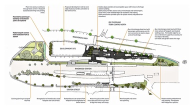
Document, Ringwood Transit City Public Domain and Landscape Guidelines (Railway Precinct, Ringwood, Victoria) 2012
4-page Urban Planning/Urban Design/Landscape Architecture guidelines for the design of street furniture, paving treatments and signage elements throughout the railway station precinct.Department of Transport. Aurecon & Grimshaw Architects. -
 Churchill Island Heritage Farm
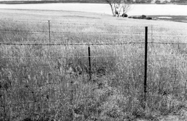
Photograph of landscape with wire fence, Unknown
Churchill Island Heritage Farm has a large photograph collection dating from the mid-nineteenth century to the last decade. This series of photographs show the restoration and building of the Churchill Island precinct and the enormous amount of collaboration and work that went into the development of the heritage area.Black and White landscape photograph of a pasture on Churchill Island with a barbed wire fence in the foreground. In the background,the inlet between Phillip Island and Churchill Island can be seen.Catalogue number written on reverse in pencil.photograph, churchill island, bridge -
 Churchill Island Heritage Farm
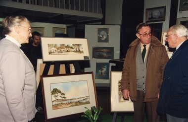
Photograph - Photograph of small art exhibition with people
Churchill Island Heritage Farm has a large photograph collection.Colour photograph of displayed landscape photographs of different aspects of Churchill Island with three people gathered around the stand. In the background, there are multiple other paintings of Australian scenery.MPAINT 4 VOLS 100 Catalogue number written on reverse in pencil churchill island, photograph -
 Bendigo Historical Society Inc.
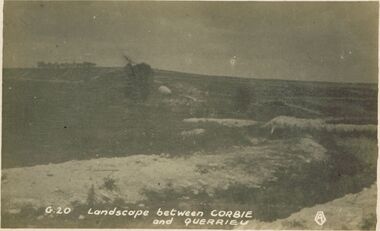
Postcard - ACC LOCK COLLECTION : LANDSCAPE BETWEEN CORBIE AND QUERRIEU, POSTCARD, 1914-1918
Postcard, WW1, B&W image of a barren landscape between Corbie and Querrie. Indistinct tree in middle ground with a row of trees in the background. Copy G 20postcard, postcard, ww1, france, corbie, querrieu -
 Victorian Interpretive Projects Inc.
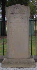
Photograph - Colour, Clare Gervasoni, Headstone of the grave of William Henry Bacchus, 14/01/2012
Captain William Bacchus was an early settler in the area now known as Bacchus Marsh. Bacchus died in 1849 aged 67. The town of Bacchus Marsh is named after him.Colour photograph in digital format of a grave in a grassy landscape. It is the headstone of early settler William Henry Bacchus in the grounds of the Holy Trinity Anglican Church, Bacchus Marsh. bacchus marsh, william bacchus, holy trinity, churchyard, cemetery -
 Benalla Art Gallery
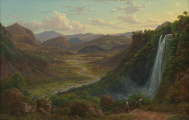
Painting, Eugene VON GUERARD, The fall of the Veliono near Terni with the view up the Valley of the River Nera, 1885
Born: Vienna, Austria 1811; Arrived: Melbourne, Victoria, Australia 1852; Died: London, Middlesex England 1901RomanticismLedger Gift, 1984Rural valley and mountain landscape with two figures walking down a track beside a waterfall towards a river. Gold brushed gesso decorative edged timber frame.Recto: Signed and dated "Eug.V.Guérard / D. 85" in red oil in l.r.c of composition; Not titledpainting, landscape, river, cliff, mountain, figures, buildings, waterfall, sky, clouds -
 Benalla Art Gallery
Painting, John Ford PATERSON, Miner’s cottage, 1884
Born: Dundee, Forfarshire,Scotland 1851; Arrived: Melbourne, Victoria, Australia 1872; Lived and worked: Scotland 1875-1884; Died: Carlton, Victoria, Australia 1912VictorianLedger Bequest, 1993Oil on canvas on composition board, depicting a rural landscape and miner's commune off a dirt road. Gold brushed timber frame with decorative gesso edges and corners Recto: Signed and dated “J FORD PATERSON / 1884” in blue oil in l.r.c of composition; Not titledpainting, landscape, house, trees, path, road -
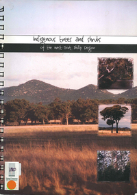 Victorian Aboriginal Corporation for Languages
Book, Elise Jeffery, Indigenous trees and shrubs of the west Port Phillip region, 2000
A series of information sheets on the west Port Phillip region, divided into zones, giving a guide to the tree and shrub species that occurred in those areas and where in the landscape they occurred.maps, b&w photographs, colour photographs, illustrations, word lists, wall mapindigenous plants, vegetation, species guide, revegetation -
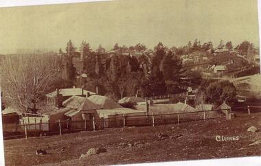 Clunes Museum
Photograph
PHOTOCOPY OF A PHOTOGRAPH OF CLUNES LANDSCAPE TAKEN FROM HILL STREET, TELEGRAPH HOTEL[KEEBLES] AND GOVERNMENT BRIDGE IN CENTRE GROUND, LOOKING TOWARDS CRESWICK AND SMEATON ROAD.local history, photography, photographs, clunes landscape -
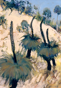 Nillumbik Shire Council
Painting: Piers BATEMAN (b.1947, Perth - d.2015, NSW), Piers Bateman, Blackboys, 1989
Piers Bateman was a local artist, held in very high esteem by his peers and community. He was born in Perth in 1947, moving to Eltham in 1955 as a young child with his family. In 1966 Bateman moved to London for eighteen months to develop his craft. In 1969 he settled in St Andrews, where he built a studio. The St Andrews locale is said to have been a strong influence on his work. Bateman’s talent was such that he was promoted and mentored by such ilk as Charles Blackman, Clifton Pugh and Arthur Boyd, among others. Bateman’s work is an intimate dialogue with the environment, renowned for his paintings of the outback, wilderness frontiers and the sea. He spent a year in the mid-seventies sailing the Greek Islands and the French canals to Amsterdam. In 1980 Bateman and Marcus Skipper embarked on a trans-Australian venture to the red centre and across northern Australia from Cairns to Broome. In the mid-eighties Bateman returned to the Mediterranean, before returning to the Australian outback in the late-eighties. His international career continued on an upwards trajectory between the Australian outback and European seas, providing a unique contrast throughout the course of his career. Bateman's work questions our relationship with the natural world, and in particular, reconciling our colonial heritage with our indigenous past. This line of questioning and his genuine response to place is the key to Piers Bateman’s work, for which he is lauded and celebrated. On September 4th 2015, Piers Bateman died in a boating accident on the NSW coast line. Piers Bateman was an instinctive painter whose inspiration came from nature. He reworked and scraped off the paint, moving it around until forms and colours of the landscape took shape. Although Bateman lived in Spain and Italy, his time in Europe made him aware of the contrast between the two continents and the bright clear light that defined the Australian landscape. At the time of this work, Bateman was living in St. Andrews, but travelled regularly to New South Wales and South Australia on painting trips. The ‘Grass Tree’ Xanthorrhoea johnsonii (commonly known as ‘blackboy’) is indigenous to these areas. It is a uniquely Australian, slow growing plant with twenty-eight species growing within Australia. Old examples of this tree are survivors of many wild fires, which can cause their blackened trunk, of one to two metres, branch into two or more heads. These heads consist of thick, rough corky bark, surrounded by long, wiry leaves and flowers that produce seed capsules with hard black seeds. The tree’s ability to be one of the first to flower after a wild fire ensures a food source for many insects and birds.Oil on canvas painting. Detail of three grass trees resting on the side of a mountain/hill. Green and gold palette throughout depicting the colours and light of the Australian landscape. Hand written, low right in capitals: 'BATEMAN'bateman, grass trees, xanthorrhoea johnsonii, landscape -
Lakes Entrance Regional Historical Society (operating as Lakes Entrance History Centre & Museum)
Photograph, Lakes Post Newspaper, 1/06/1996 12:00:00 AM
Black and white photograph of Greg Jenkins and Scott Cassells of Lakes Entrance Landscapers in a cherry picher about to prune a tall tree with a chainsaw Lakes Entrance Victoriabusinesses -
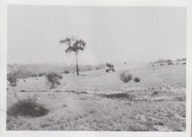 8th/13th Victorian Mounted Rifles Regimental Collection
Photograph - AFV Range scene
The 8th/13th Victorian Mounted Rifles was raised as a regiment of the Royal Australian Armoured Corps on 1 May 1948 with Headquarters in Melbourne and squadrons in Sale, Benalla/Wangaratta and Albury. In 1955 Regimental Headquarters moved to Wangaratta and a second squadron was located at Albury. The Sale squadron transferred to 4th/19th Prince of Wales’s Light Horse. In 1977 8/13 VMR Regiment was reduced to an independent squadron A Squadron 8th/13th Victorian Mounted Rifles and in 1991 was linked with 4th/19th Prince of Wales’s Light Horse forming the VMR Squadron of that regiment.Unique collection of photographs showing the first years of an armoured regiment of the post-Second World War era Citizen Military Forces showing equipment, uniforms, training and social activity and some personalities.Black and white photograph of General Grant tank in a bush landscape. One of a collection of photographs of 8th/13th Victorian Mounted Rifles Regiment between 1948 and 1951.General Grant training daystank, gereral grant, cmf -
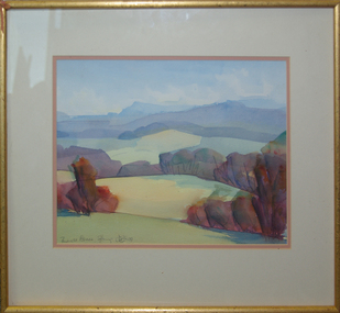
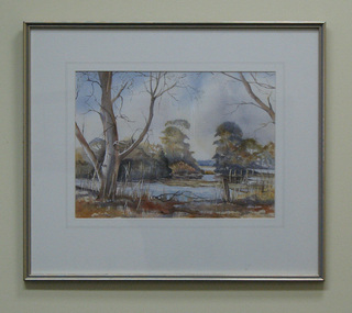 South Gippsland Shire Council
Painting, Watercolour, …at Carmody's Road
Framed watercolour featuring a landscape painted by Adriene Dietrich. Silver metal frame with white card window mount. Painted predominately in shades of blues, brown and greys. -
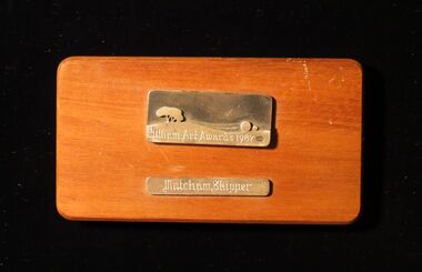 Montsalvat
Wood Plaque, Eltham Art Awards
Rectangular wood plaque with two bronze plates; the top plate depicting a landscape and the inscription 'Eltham Art Awards 1987' and the lower plate the inscription 'Matcham Skipper'.Inscribed 'Eltham Art Awards 1987' with an oval containing the number 0256 and 'Matcham Skipper'matcham skipper, plaque, eltham art awards -
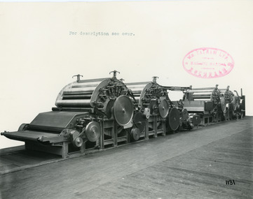 National Wool Museum
Photograph - Product Photograph, Semi-Continental Card Set
These are sales photographs for William Tatham Ltd. of Rochdale. These photographs are taken in the fitting shop at William Tatham Ltd. where final assembly would have taken place. A carding machine disentangles and cleans wool fibres and then aligns the individual fibres so that they are parallel with each other.The photographed machine was made by William Tatham Ltd, a textile engineering company based in Rochdale, UK. Established in 1866 Tatham developed innovative textile machinery and send their products to Australia and other countries around the world.Two black and white photos of an Semi-Continental Card Set in a landscape format. The first photo is of the whole machine, the second is a close up of the mid section of the machine.8038.1 - Front - top margin: For description see over. Front mid right edge - Wm. TATHAM Ltd. ROCHDALE. Machine Maker Front bottom right corner - 1131 Rear - Semi-Continental Card Set arranged to receive latest pattern Automatic Feed fitted with Peralta, improved type Parallel Fiber Feed permitting of passageway between Scribbler and Carder. Four-tier Continuous Tape Condenser. 8038.2 - Front - top margin: For description see over. Front mid right edge - Wm. TATHAM Ltd. ROCHDALE. Machine Maker Front bottom right corner - 1132 Rear - Showing Peralta with hydraulic pressure to rollers and working with improved pattern Parallel Fibre Feed arranged with passage between the two main sections.textile machinery, tatham, carding machine, wool manufacture -
 Federation University Art Collection
Painting - Watercolour, 'Towards Avoca' / 'Mount Buninyong in Autumn' by David Alexander, 1999
This item is part of the Federation University Art Collection. The Art Collection features over 1000 works and was listed as a 'Ballarat Treasure' in 2007.Unframed double sided landscape artwork by David Alexander. One side is 'Towards Avoca' and the other side is 'Buninyong From Main Road, 24/04/1999'David Alexander wrote on 'Buninyong From Main Road, 24/04/1999' "Wash wouldn't dry. People everywhere"art, artwork, david alexander, alexander, buninyong, avoca, watercolour