Showing 10465 items
matching plans
-
 University of Melbourne, Burnley Campus Archives
Work on paper (item) - Student Work, Sandra Brizga, Andembach - Riverside Garden Planting Plan, 8 November 2018
Made as an assignment for HORT90035, a subject at Burnley Horticultural College coordinated by Andrew Laidlaw. assignment, burnley horticultural college, hort90035 -
 Kew Historical Society Inc
Plan - Subdivision Plan, Kew Golf Links Estate, 1936, 1936
The Kew Golf Links Estate was a major subdivision in North Kew. It derived its title due to the land being previously occupied by the Kew Golf Club, which transferred its course to a number of locations before occupying its current site. The Plan advertises 180 choice home sites. The street names are somewhat different today as those on the map are named after the proposed Kodak Factory to be built on the site. The subdivision of the Kew Golf Links Estate was a major subdivision of farmland in Kew. The site was at one stage designated for industrial development and the building of a new Kodak factory. The decision by Council to oppose the redevelopment makes the beginning of the period when all industrial development was banned in Kew.Monochrome printed, folded subdivision plan for the Kew Golf Links Estate, to be auctioned on 7 November 1936. Streets named include: Carnegie Avenue, Willsmere Road, Kilby Boulevarde, Kodak Avenue, Coleman Avenue, Beresford Avenue, McConchie Avenue, Cole Avenue, White Avenue, Baker Avenue, Spruzen Avenue, Tanner Avenue, Ratten Avenue, Mathers Avenue, Railway Avenue, Sutherland Avenue, and Belford Road. The position of the Yarra River and a large Drainage Reserve are marked on the plan. Lots for sale are numbered. Existing buildings are designated with a square.subdivision plans - kew (vic), kodak factory - kew (vic) -
 City of Kingston
Pamphlet - Colour, Roy Dunn Pty. Ltd, Central Corner Estate Moorabbin and Highett, c. 1923
Sales plan for land in the suburbs of Highett and Moorabbin, bordered by Point Nepean Road and Wickham Road East incorporating William StreetThe developing urban area of Highett and Moorabbin within the City of Kingston. This land sale pamphlet illustrates the subdivision of land within the municipality and the changing demographic of the district as new houses are constructed close to infrastructure.Colour pamphlet advertising for private sale land in the Central Corner Estate in Moorabbin and Highett. Incorporates a map of the estate bordered by Point Nepean Road and Wickham Road East, with subdivisions also available on both sides of William Street. Handwritten in blue pencil on subdivision plan: a tick is drawn on subdivisions 2-18 Handwritten in blue pencil on subdivision 6: a box with an x inside Handwritten in blue pencil on subdivisions 10 and 12: S Handwritten in black ink on front page: [indecipherable] / McKittricks Handwritten in grey pencil on rear page: McKilhick / Nepean Rd Handwritten in grey pencil on rear page upside down: 160000 / 15 8300 [crossed out] land sales, estate, highett, moorabbin -
 Bendigo Historical Society Inc.
Map - Marong County of Bendigo
Map of Marong. Drawn and reproduced at the Dept. of Lands and Survey, Melbourne. By authority: W.M. Houston Government Printer. June 1953.On the back in blue pen: certified plan parish Marong, signed minister and seal affixed for land S sec.72 evidence act. I certify that this a true plan parish Marong (signature illegible) minister for lands.map, marong -
 Federation University Historical Collection
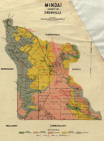
Plan, Mindai County of Grenville
Plan of MIndai showing geological eras.plan, geology, mindai, pitfiled plains, old pitfield plains, william mckay, g. curie, l. lowe, d. mcnaught, grand trunk lead, patrick shelton -
 Federation University Historical Collection
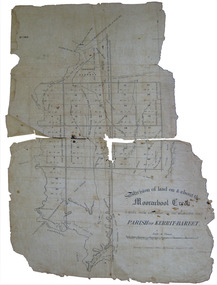
Plan, Eugene Bellairs, Moorabool Creek, Parish of Kerrit-Bereet, 01/08/1855
Plan of the Moorabool Creek on the Melbourne Roadmoorabool, kerrit-bareet, moorabool creek, eugene bellairs -
 Federation University Historical Collection
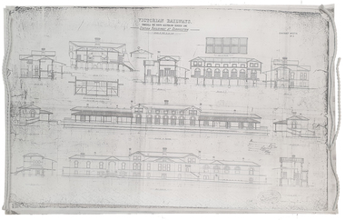
Plan, Copy of a Plan of Serviceton Railway Station Building, 1888
The Serviceton Railway Station was completed in 1889 , with the Colony of Victoria and the Colony of South Australia sharing the cost. Ut was at Serviceton the the Victorian rail line and the Adelaide-Wolseley railway line of South Australia joined. The Railway Station included customs offices which were no longer necessary after the Federation of Australian States in 1901. ( https://en.wikipedia.org/wiki/Serviceton,_Victoria, accessed 30 August 2021)Copy of plan for the Serviceton Railway Linerailway, servicetone railway station, plan, serviceton -
 Greensborough Historical Society
Pamphlet, Upgrading Yan Yean Road, 2017_11
VicRoads let a contract for the upgrade of Yan Yean Road between Diamond Creek Road and Kurrak Road in October 20174p. text and col. photographs and plan.yan yean road -
 City of Moorabbin Historical Society (Operating the Box Cottage Museum)
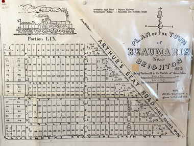
Document, photocopy of Plan of Beaumaris 1853, c1960
Beaumaris includes two early estates in the parish of Moorabbin developed by Josiah Holloway from 1852. Named Beaumaris Town and Beaumaris Estate (after the pastoral run in the area and ultimately after Beaumaris in Wales), the lots comprising them were marketed by Mr Holloway's suggesting that the railway was imminent and a canal would be built. The township developed slowly, a Post Office opened on 1 March 1868, but was replaced next month by Gipsy Village office (now Sandringham) In 1862 Beaumaris was one of the early settler communities within the boundaries of the Moorabbin District Roads Board , the region’s first local government authority. Beaumaris is a suburb in Melbourne, Victoria, Australia, 19 km south-east from Melbourne's central business district. .Since the Amalgamation of Councils 1994 the local government area is the City of Bayside which includes Brighton. A Photocopy of the Plan of Beaumaris 1853 A3moorabbin, county of bourke, brighton, beaumaris, pioneers, early settlers. market gardeners, cheltenham, king. john, holloway josiah, whorral charles, arthur’s seat road, nepean highway, morabbin district roads board, sandringham, mordialloc, mentone -
 Ringwood and District Historical Society
Administrative record, Packet: Ringwood City Council - Community Plan 1986
City Council Community Plan - 1986 -
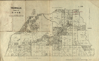 Federation University Historical Collection
Parish Plan, Parish Plan of Trawalla in the Parish of Rippon, 1913, 28/4/1913
Trawalla is surrounded by Beaufort, Brewster, Lillirie, Yangerahwill and Eurambee.Parish Plan of Trawalla in the Parish of Rippon. trawala, ripon, westbrok, simson, mackenzie, mcarthur, wilson, nicholason, gibb, read, hayward, topper, foreman, bell, mcmillan, halpin, davis, goldsmith, trawalla pre-emptive right, butson, w.j. butson, m4471, w. read, c.a. foreman, j. simson, a. goldsmith, trawalla, g. topper -
 Federation University Historical Collection
Plan, King River Mine, 1932, 12/1932
Copy of a plan of King River Mine.mount lyell, king river, mining, tasmania, king river mine, k.m. white, h. turner, k.j. finnacane, blake -
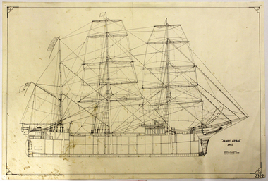 Flagstaff Hill Maritime Museum and Village
Document
Reproduction of Plans of the James Craig,1903flagstaff hill, warrnambool, shipwrecked-coast, flagstaff-hill, flagstaff-hill-maritime-museum, maritime-museum, shipwreck-coast, flagstaff-hill-maritime-village, document, plans of the james craig, plan -
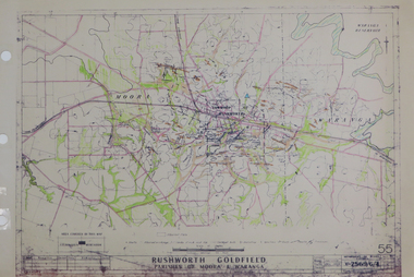 Federation University Historical Collection
Plan, Rushworth Goldfield: Parishes of Moora and Waranga, pre 1954
Printed plan on paper with hand colouringrushworth, moora, waranga -
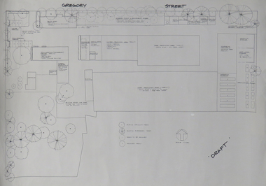 Federation University Historical Collection
Plan, Ballarat School of Mines Horticulture Centre, Gregory St, Ballarat
Plan for the Gregory Street Horticulture Centre.ballarat school of mines, horticulture, school of horticulture, horticulture building, gregory street, architectural plan -
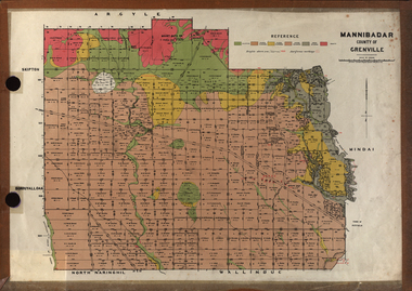 Federation University Historical Collection
Plan, Mannibadar Geological plan
Coloured plan of Mannibadar, County of Grenville.mannibadar, pitfield, mount bute, emu hills, woady yalouk river, geology, plan -
 Federation University Historical Collection
Blueprint Plan, Crane Transversing Trolley, 1934-5
Blueprint plan of a crane-transversing-trolley v. hunt, plan, chambers, crane tranversing pulley -
 Federation University Historical Collection
Plan, Plan of Part of Section 9A City and Parish of Ballarat, 1933
Hand drawn ink plan with colouringsmb buildings, ballarat school of mines, buildings, model mine, mining laboratory, grant street, lydiard street south, dana street, albert street, old chemistry building, architectural plans -
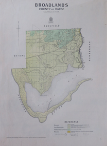 Federation University Historical Collection
Map, Broadlands, County of Dargo, 1887
Plan of Broadlands, County of Dargo, Victoria.broadford, j.g. easton, dargo, geological -
 Federation University Historical Collection
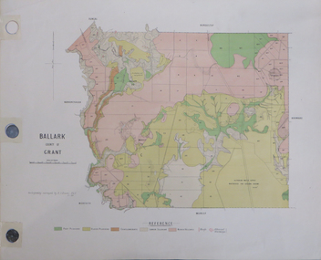
Plan, Ballark: County of Grant, 05/01/1889
A geological plan of Ballark in the County of Grant.moreep, mount wallace, ballark -
 City of Moorabbin Historical Society (Operating the Box Cottage Museum)
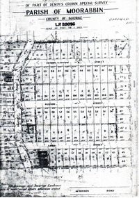
Flyer - Garfield Estate, Ormond
At the end of World War One, there was a renewed interest in residential land and a number of estates opened up in the Municipality of Moorabbin.Example of the progress of the Municipality of MoorabbinPhotocopy of the plan of the Garfield Estate, OrmondPart f Dendy's Crown Special Survey - parish of Moorabbin - County of Bourke - Garfield Estatedraper street, lord street, hudson street, blackshaw street, tucker road, ormond, mckinnon, real estate -
 City of Moorabbin Historical Society (Operating the Box Cottage Museum)
Book, Colorgravure Publications [for] The Herald & the Sun news-pictorial, Queen Elizabeth's coronation book, 1953?
"This book is right royally produced to be a treasured exhibit in the library of every home. Seven separate distinct printing operations have gone to make the beautiful, vivid coloring which distinguishes it as an object of fine and lasting craftsmanship. No pains have been spared to produce a fitting volume to mark the beginning of the Age of Queen Elizabeth the Second, and the publishers proudly present it as a book which their readers will rejoice to own."--Front flap.[48] pages : colour illustrations, plans ;non-fiction"This book is right royally produced to be a treasured exhibit in the library of every home. Seven separate distinct printing operations have gone to make the beautiful, vivid coloring which distinguishes it as an object of fine and lasting craftsmanship. No pains have been spared to produce a fitting volume to mark the beginning of the Age of Queen Elizabeth the Second, and the publishers proudly present it as a book which their readers will rejoice to own."--Front flap.queen elizabeth ii, coronation -
Port Melbourne Historical & Preservation Society
Plan - Furniture, Council Chamber, Port Melbourne Town Hall, Port Melbourne City Council, 8 Jul 1938
Plan for Council Chamber furniture, 1938port melbourne town hall, city engineers, fred cook -
Port Melbourne Historical & Preservation Society
Plan - Footbridge, Borough of Sandridge, 1860 - 1884
Plan for a footbridge, Borough of Sandridge, undated.Signed by Charles Clay and Gordon Fyfe.built environment - civic, charles clay, gordon fyfe -
 Monbulk RSL Sub Branch
Book, Big Sky Publishing, Combat medic : an eyewitness account of the Kibeho massacre, 2008
On the 22nd of April 1995 more than 4,000 Rwandans were massacred and thousands more injured in a place called Kibeho. Terry Pickard, a seasoned soldier and medic, was one of a 32-strong force of Australian UN peacekeepers in Kibeho on that terrible Saturday. While the United Nations’ presence prevented the death toll from being even worse than it was, the massacre continues to haunt him. The rules of engagement that stopped him from intervening in the senseless slaughter, and the life and death decisions he was forced to make when dealing with the injured condemned him to more than a decade of recurring nightmares and debilitating flashbacks. The horror and unimaginable tragedy of the Kibeho Massacre still looms large in the lives of Rwandans and the people sent to help the African country. No one who walked away from that day was ever the same again. Combat Medic is a personal account of one Australian soldier who found himself at the centre of events that shocked the world, and the personal toll that he paid. Terry Pickard’s army career spanned nearly 20 years. More than 25 years after Rwanda he continues to struggle with post traumatic stress triggered by his experiences. Collapse summaryIll, maps, plans, p.181.non-fictionOn the 22nd of April 1995 more than 4,000 Rwandans were massacred and thousands more injured in a place called Kibeho. Terry Pickard, a seasoned soldier and medic, was one of a 32-strong force of Australian UN peacekeepers in Kibeho on that terrible Saturday. While the United Nations’ presence prevented the death toll from being even worse than it was, the massacre continues to haunt him. The rules of engagement that stopped him from intervening in the senseless slaughter, and the life and death decisions he was forced to make when dealing with the injured condemned him to more than a decade of recurring nightmares and debilitating flashbacks. The horror and unimaginable tragedy of the Kibeho Massacre still looms large in the lives of Rwandans and the people sent to help the African country. No one who walked away from that day was ever the same again. Combat Medic is a personal account of one Australian soldier who found himself at the centre of events that shocked the world, and the personal toll that he paid. Terry Pickard’s army career spanned nearly 20 years. More than 25 years after Rwanda he continues to struggle with post traumatic stress triggered by his experiences. Collapse summary united nations - peacekeeping forces - rwanda, rwanda - civil war - atrocities -
Bendigo Historical Society Inc.
Map - REDCASTLE AND DARGILE, No date visible
Map: Redcastle and Dargile. Parish planmap, parish plan, redcastle, dargile -
 Monbulk RSL Sub Branch
Book, Jane's Publishing Company, Warships of the world, 1980
A description of various warships listed by categoryIndex, ill, plans, p.224.non-fictionA description of various warships listed by categorywarships - history, warships - development -
University of Melbourne, Burnley Campus Archives
Document, Graduate Destination Survey 2003, 2004
University of Melbourne, University Planning Officegraduates, survey, 2003, university of melbourne -
University of Melbourne, Burnley Campus Archives
Document, VCAH Dookie Centennial Steering Committee, 1984-1985
Initial planning proposal, minutes, etc.vcah, dookie, centennial -
Stawell Historical Society Inc
Archive - Books & Papers, The Australian Sketcher Article Stawell and the Pleasant Creek reefs July 12 1873, July 12 1873
Article printed after legislation arising out of 'Jumped Claims' back in history of Pleasant Creek - alluvial and quartz mining Currant mining operationsPhotocopy of article with lithographs and plan of Stawell