Showing 12221 items matching " reserves"
-
 Eltham District Historical Society Inc
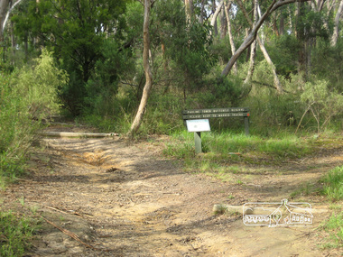
Photograph, Liz Pidgeon, Pauline Toner Butterfly Reserve, Eltham, 18 February 2011, 18 February 2011
Signage in the Pauline Toner Butterfly Reserve asking visitors to keep to marked tracks. The Reserve at the corner of Pitt Street and Eucalyptus Road, Eltham is managed by Parks Victoria. It is named for Pauline Toner M.P. who after the re-discovery of the rare Eltham copper Butterfly in large numbers in Eltham in 1987 worked to preserve its habitat.Born Digitalpauline toner reserve, eucalyptus road, copper butterfly, nature reserve, walking trail, sign, erosion -
 Eltham District Historical Society Inc
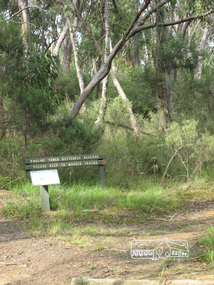
Photograph, Liz Pidgeon, Pauline Toner Butterfly Reserve, Eltham, 18 February 2011, 18 February 2011
Signage in the Pauline Toner Butterfly Reserve asking visitors to keep to marked tracks. The Reserve at the corner of Pitt Street and Eucalyptus Road, Eltham is managed by Parks Victoria. It is named for Pauline Toner M.P. who after the re-discovery of the rare Eltham copper Butterfly in large numbers in Eltham in 1987 worked to preserve its habitat. Born Digitalpauline toner reserve, eucalyptus road, copper butterfly, walking trail, sign, nature reserve -
 Stawell Historical Society Inc
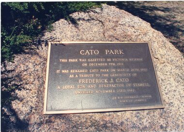
Photograph, Cato Park Plaque -- renaming the park in honour of Mr F J Cato -- Coloured
Cato Park Plaque. The information on the plaque states the name change from Victoria Reserve to Cato Park in 1930. Victoria Reserve was gazette in c 1914 then had a name change in 1930 to Cato park. The Park renamed after Frederick J. Cato in contribution to his generosity to the Stawell community. The plaque was unveiled on 23rd November 1982.Colour photograph of Cato Parks bronze plaque on a stone located near the Cato Park entrance gate. The plaque acknowledges the name change of the Park from Victoria to Cato Park in c 1930 and the plaque was unveiled in c 1982. stawell -
 Glen Eira Historical Society
Article - DUNCAN MACKINNON RESERVE
... Reserves ...This file contains five items: 1/Item one is a newspaper article describing the plans for the restoration and development of the new pavilion. It includes figures, benefits and potential uses of the pavilion. Dated August 2012. 2/ An article from the Caulfield/Port Phillip Leader describing the new pavilion. Dated 21/08/2012. 3/A report from the Caulfield Contact detailing the history of Duncan MacKinnon Reserve. It also includes funding and planning for the upgrade to a park status, with new facilities. Dated December 1991. 4/Report by Caulfield Historical Society, with the original typed copy, describing historical changes from 1874 to 1976, and its transformation from a swamp to sporting ground. Includes figures, grants, and its changing uses by the community. Undated. Three copies in file. 5/Two photographs, an original and a smaller copy of the original, of children playing at the reserve. Undated.duncan mackinnon reserve, glen eira, murrumbeena, caulfield, north road, crosbie road, murrumbeena road, caulfield historical society, caulfield council, caulfield contact, caulfield little athletics, judge mark, hyams jamie cr, glenhuntly athletics club, caulfield district netball association, stanish jane, biggs ed cr, dixon brian, taylor sam cr, crosbie thomas mahoney, mackinnon duncan cornelius, sports establishments, pavilion, sporting clubs, athletics, competitions, swamps, playgrounds, barbeques, warren reserve, councillors, paddy’s swamp, glen eira council, sports equipment, recreations equipment, victorian masters athletics, maccabi athletics club, washington park cricket club, sports grounds, ovals, playing fields, stadiums, duncan mackinnon park, caulfield’s east ward, victorian veterans cricket club, caulfield south, crosbie swamp, caulfield park, football clubs, cricket clubs, athletic clubs, caulfield/port phillip leader, mantric architecture, parks, reserves, martens veronika cr, caulfield historical society -
 Greensborough Historical Society
Photograph - Digital Image, Pioneer Reserve 2014 -1, 21/05/2014
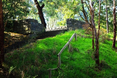
Pioneer Reserve, Greensborough is a small park on the corner of St Helena and Diamond Creek Roads. It is adjacent to the site of Greensborough's first bridge across the Plenty River, c. 1864 - 1960s. The shelter, viewing platform, retaining wall and entrance are built from the bridge's massive bluestone arched abutments dismantled between 1974 and 1983. Pioneer Reserve is historically significant for its formative association with noted local landscape designer Gordon Ford in 1968, and it is likely that remnant large field stones at the entrance drive to the Reserve remain from his design. Photograph by Marilyn Smith 2014.Digital copy of colour photograph. -
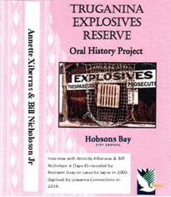 Truganina Explosives Reserve Preservation Society Inc (TERPS)
Digitised Oral History – Truganina Explosives Reserve - Tape 8 Annette Xibarras and Bill Nicholson Jnr, 2018
The interviews were recorded in 2000 by Bronwen Gray and Alan Young for the production of Unreserved, Stories from Truganina Explosives Reserve, animated stories from past residents, workers and interested people of the Reserve (subject to copyright 2004). Annette Xibarras and Bill Nicholson Jnr discuss the indigenous significance of the Truganina Explosives Reserve. At the time of the interview Annette was the manager of the Kulin Nations Cultural Heritage Organisation. Bill, a Wurundjeri Elder, was a Wurundjeri Cultural Officer. They discussed their childhood, aboriginal customs, connection with the land and the locating of aboriginal remains at the Museum of Victoria and the re-burial at the site where they were found. A primary source of information on memories of the Truganina Explosives Reserve and Altona,VictoriaDigital copy of original cassette recorded in 2000 and digitised in 2018julia jones, princess balam balam, archaeological survey, middens, wurundjeri, kulin nations, coranderrk, braybrook, sacred sites, mt william, bunurong, museum victoria, altona, martha nicholson -
 Truganina Explosives Reserve Preservation Society Inc (TERPS)
Digitised Oral History – Truganina Explosives Reserve - Tape 9 Andrew Shannon and Judy Hindle, 2018
The interviews were recorded in 2000 by Bronwen Gray and Alan Young for the production of Unreserved, Stories from Truganina Explosives Reserve, animated stories from past residents, workers and interested people of the Reserve (subject to copyright 2004). Judy Hindle and Andrew Shannon worked jointly on saving the Truganina Explosives Reserve from being sold for development by the State Government. Judy was an Altona resident and Andrew was an environment planner, first with Parks Victoria and then the local council. Their motivation was to not only save the site for open space but to capture what Judy described as the only in-tact historical site in the area. A primary source of information on memories of the Truganina Explosives Reserve and Altona,VictoriaDigital copy of original cassette recorded in 2000 and digitised in 2018chirnside, explosives, tin fence, coastal vegetation, parks victoria, joan kirner, cheetham wetlands, doug grant, gahnia, salt marsh, sand ridges, rob andrew, nessie hardy, aboriginal middens, altona, truganina swamp -
 Greensborough Historical Society
Newspaper Clipping, Diamond Valley Leader, Club to display signs at reserve, 30/05/2018
A dozen advertising signs will be posted at A. K. Lines Reserve in Watsonia, being for sponsors of the Watsonia Sporting ClubNews article 1 page, black text.a k lines reserve, watsonia, watsonia sporting club -
 Greensborough Historical Society
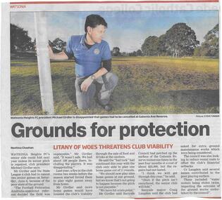
Newspaper clipping, Grounds for protection, 17/06/2015
Watsonia Heights Football Club could fold in 2016 unless its ground at Gabonia Reserve was repaired.News clipping, black text, colour image.watsonia heights football club, gabonia reserve -
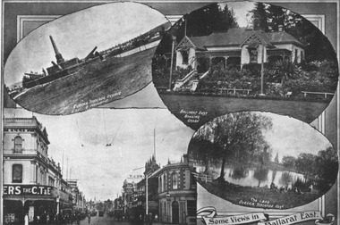 City of Ballarat Libraries
Postcard, Postcard with Ballarat East scenes circa 1917
The postcard depicts the Eureka Memorial and lake at the Eureka Reserve, the Ballarat East Bowling Club and Bridge Street.building, streetscape, public, commerical, ballarat east, eureka, bridge street, ballarat east bowling club, eureka reserve -
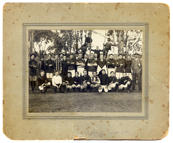 Tarnagulla History Archive
Football players in Tarnagulla, 1913
Murray Comrie Collection. This photo was probably taken at either Victoria Park or the Recreation Reserve in Tarnagulla, Victoria.Group of men and boys, some in football attire posed as a group in an outdoor area with gum trees behind them. Three boys are standing in/on trees at rear. Main in suit at far right. Handwritten on reverse are names of some subjects, the name 'L.Williams', the name and address 'J. Sheldon, 1 Francis Grove Thornbury' and the phrase 'Tarnagulla near Bendigo'. '1913 Wednesday' handwritten on front.tarnagulla, sport, football, radnell family, smith family, burstall family, bert family, whimpey family, shelton family, robinson family, chapman family, birchall family, ousley family, harwood family, ison family, kilgower family, bock family, norwood family, rivvett family, abbot family -
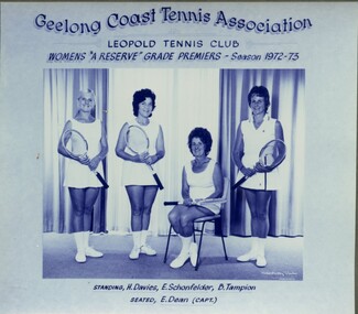 Leopold Tennis Club
Photograph, Robert Pockley Studios, Geelong Coast Tennis Association Leopold Tennis Club Womens A Reserve Grade Premiers - Season 1972-73, 1973
Image taken of the Geelong Coast Tennis Association - Womens A Reserve Grade Premiers for Season 1972-73.1 photograph of Premiership tennis teamStanding: H. Davies, E. Schonfelder, B. Tampion Seated: E. Dean (Capt.)leopold tennis club, geelong coast tennis association, helen davies, e schonfelder, barbara tampion, ethel dean -
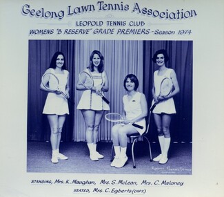 Leopold Tennis Club
Photograph, Robert Pockley Studios, Geelong Lawn Tennis Association Leopold Tennis Club Womens B Reserve Grade Premiers - Season 1974, 1974
Image taken of the Geelong Lawn Tennis Association Womens B Reserve Grade Premiers for Season 1974.1 photograph of Premiership tennis teamStanding: Mrs K. Maughan, Mrs S. McLean, Mrs C. Maloney Seated: Mrs C. Egberts (Capt.)leopold tennis club, geelong lawn tennis association, k maughan, s mclean, cathy maloney, c egberts -
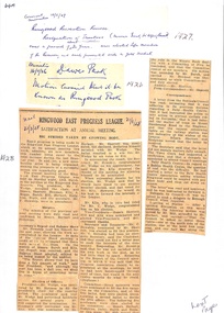 Ringwood and District Historical Society
Newspaper, Newspaper Articles Ringwood Borough Council from 1906 to 1929
18 pages of newspaper articles featuring council reports on Ringwood and Ringwood East ranging from the years 1906 to 1969. Featuring articles: Ringwood East Progress League, Ringwood East Railway League, Ringwood East Reserve, Ringwood East School Committee and the Ladies Guild. East Ringwood Recreation Ground. -
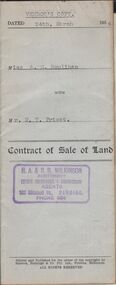 Bendigo Historical Society Inc.
Document - H.A. & S.R. WILKINSON COLLECTION: CONDITION OF SALE
Contract of sale of land dated 24th March, 1954 between miss A.M. Houlihan (seller) and Mr. W.T. Priest (buyer) for land situate 12 Reserve Street Eaglehawk described in Right to Occupy Residence Area No. 5362, together with weatherboard dwelling and all sundry. Price 1,000 pounds. Vendor's copyorganization, business, h.a. & s.r wilkinson real estate -
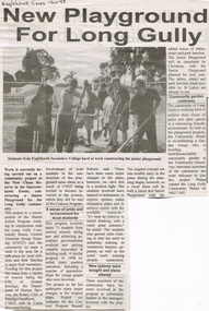 Bendigo Historical Society Inc.
Newspaper - LONG GULLY HISTORY GROUP COLLECTION: NEW PLAYGROUND FOR LONG GULLY
Newspaper cutting titled New Playground for Long Gully. Eaglehawk Times Nov 99 written at the top of the article. The playground was a community project at the New chum Reserve in the Sparrowhawk, Estate. Mentioned is the organisers, who gave funds for the works and the young people who worked on it. Also mentioned is some early problems they had.bendigo, history, long gully history group, the long gully history group - new playground for long gully, eaglehawk times nov 99, eaglehawk secondary college, new chum reserve, long gully community house, central victorian group training (cvgt), city of greater bendigo, the department of human services, the rotary club of bendigo/sandhurst, lt lukes, russell roberts -
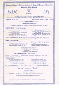 Bendigo Historical Society Inc.
Document - LYDIA CHANCELLOR COLLECTION; ANZAC DAY COMMEMORATION CEREMONY
One white sheet with blue printing. On the sheet are the words' Returned Sailors' Soldiers & Airmen's Imperial League of Australia, Bendigo Sub-Branch ANZAC Day Commemoration Ceremony.' Friday April 25th. 1952. Includes speeches, music prayers. Situated at the Upper Reserve. Collections 'in aid of distressed and indigent ex servicemen.'event, official, anzac memorial service, lydia chancellor, collection, war, wwii, soldiers events, ceremonies, anzac day, program, programme -
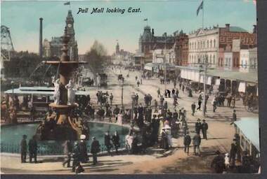 Bendigo Historical Society Inc.
Postcard - PALL MALL LOOKING EAST
Colour postcard: image shows Alexandra fountain on LH side, looking towards post Officde building. Poppet head of mine on LH side, mine chimney, Royal Reserve mine. People standing around fountain, tram behind. Pre-cars - possibly early 1900's-due to electrified tramsbendigo, streetscape, pall mall, bendigo, pall mall, alexandra fountain, royal reserve -
 Bendigo Historical Society Inc.
Document - HANRO COLLECTION: SEVENTH ANNUAL GENERAL MEETING
Chairman's Agenda for Seventh Annual General Meeting dated 3/11/1932. Items mentioned are Confirmation of Minutes, Annual Accounts & Directors Report, Share Equalization Reserve Account, Salary Managing Director, Directors 'A' Group, Directors 'B' Group, Conjoint Director, Auditors & Auditor's Remuneration and the Adoption of Provisional Agreement.hanro, clothing, share register -
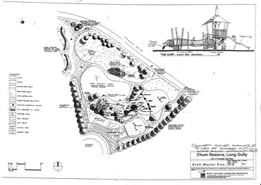 Bendigo Historical Society Inc.
Document - LONG GULLY HISTORY GROUP COLLECTION: CHUM RESERVE LONG GULLY
Copy of a plan of the Chum Reserve, Long Gully, dated September 1998. The plan between Derwent Drive and Dyason Court show play area, trees, swings, fire pit, tree house and grassy area. There is also a plan of the tree house - South East Elevation. Drawn by Mary Jeavons Landscape Architects.bendigo, history, long gully history group, the long gully history group - chum reserve long gully, shared action long gully community house, city of greater bendigo, mary jeavons landscape architects -
 Ballarat Tramway Museum
Photograph - Colour Photograph/s, Paul Mong, 29/03/2002 12:00:00 AM
Aerial photograph of the South Gardens Reserve and the Ballarat High School grounds showing the Ballarat Tramway Depot, Fish Hatchery and associated area from the north east aspect. Taken by Paul Mong 29 March 2002. On Fujicolor Crystal Archive Paper. Height of about 1000ft or 330m above ground level.btm, south gardens reserve, btm depot -
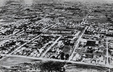 Bayside Gallery - Bayside City Council Art & Heritage Collection
Photograph, Sandringham, 1922
sandringham, aerial, victoria, suburbs, photograph, airspy, beach street, bridge street, crisp street, seaview, hampton reserve, hampton, trevor barker beach oval -
 Bendigo Historical Society Inc.
Photograph - ELMORE FIELD DAYS
Elmore Field Days were first held in 1964.Aerial photograph of Elmore Field Days site. Undated but possibly 1969-1970. Image shows exhibitor stands, roadways and parked vehicles. Oh LH side of image is a water course, an anabranch of the Campaspe River. Site is now a camping reserve as the Elmore Field Days is now (2022) held at a nearby site.event, agriculture, elmore field days -
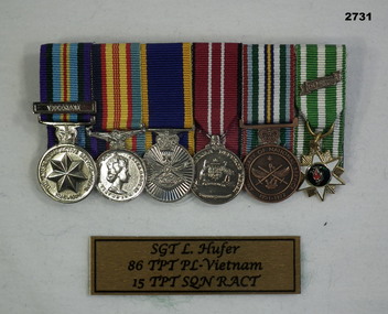 Bendigo Military Museum
Award - MEDAL SET VIETNAM, Post 1962
Lawrence Raymond Hufer No 3162733 served in Vietnam from 15.10.69 to 15.10.70. The nominal roll shows that he served in 85 Transort Platoon RAASC. He later served in 15 Transport Platoon RACT. Medal set, miniatures, court mounted, set of (6) Re L. HUFER. 1. Australian Active Service Medal with clasp "VIETNAM" 2. Vietnam campaign medal 3. Reserve Force Medal 4. Defence Medal 5. Anniversary of National service meal 6. Vietnam medal with clasp "60 -"medals, military, history, passchendaele barracks trust -
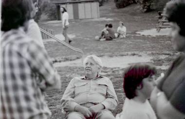 Greensborough Historical Society
Photograph - Digital Image, Labor get together Poulter Avenue 1975/76, 1975c
A group of Labor supporters enjoy a get together at Poulter Avenue Reserve in Greensborough, 1975 or 1976. Photos are not named.Digital copy of black and white photographspoulter avenue greensborough, australian labor party -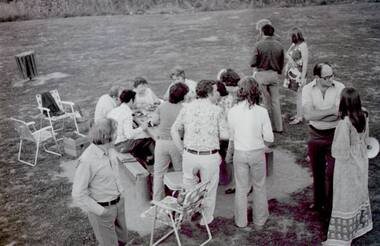
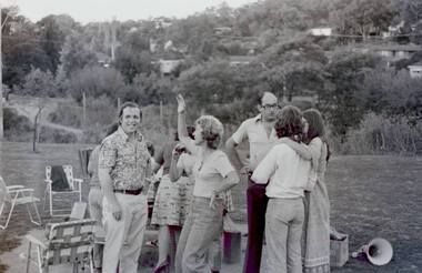
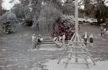
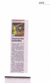 Greensborough Historical Society
Newspaper Clipping, Count on the butterflies, 07/10/2015
The annual count of Eltham Copper Butterflies took place in October 2015 at the Andrew Yandell Habitat Reserve in Greensborough.News clipping, black text, colour image.eltham copper butterflies, yandell reserve -
 Greensborough Historical Society
Photograph - Digital Image, Marilyn Smith, Medbury Avenue Reserve, 21/02/2017
Medbury Avenue runs from Greensborough to Watsonia. The Reserve is situated between Medbury Avenue and Delta Road Watsonia.Digital copy of 3 colour photographs.medbury avenue watsonia, delta road greensborough