Showing 2754 items
matching 1933
-
 Kew Historical Society Inc
Plan - Subdivision Plan, J R Mathers & McMillan, Clutha Subdivision, 1940
Pru Sanderson, in her groundbreaking ‘City of Kew Urban Conservation Study : Volume 2 - Development History’ (1988), summarised the periods of urban development and subdivisions of land in Kew. The periods that she identified included 1845-1880, 1880-1893, 1893-1921, 1921-1933, 1933-1943, and Post-War Development. These periods were selected as they represented periods of rapid growth or decline in urban development. An obvious starting point for Sanderson’s groupings involved population growth and the associated economic cycles. These cycles also highlighted urban expansion onto land that was predominantly rural, although in other cases it represented the decline and breakup of large estates. A number of the plans in the Kew Historical Society’s collection can also be found in other collections, such as those of the State Library of Victoria and the Boroondara Library Service. A number are however unique to the collection.The Kew Historical Society collection includes almost 100 subdivision plans pertaining to suburbs of the City of Melbourne. Most of these are of Kew, Kew East or Studley Park, although a smaller number are plans of Camberwell, Deepdene, Balwyn and Hawthorn. It is believed that the majority of the plans were gifted to the Society by persons connected with the real estate firm - J. R. Mathers and McMillan, 136 Cotham Road, Kew. The Plans in the collection are rarely in pristine form, being working plans on which the agent would write notes and record lots sold and the prices of these. The subdivision plans are historically significant examples of the growth of urban Melbourne from the beginning of the 20th Century up until the 1980s. A number of the plans are double-sided and often include a photograph on the reverse. A number of the latter are by noted photographers such as J.E. Barnes.The subdivision plan for the Clutha Subdivision is one of the largest in the Society’s collection. The plan includes a map of the proposed allotments, photographic views to the north and south, and information about the kinds of buildings that could be constructed on the allotments. The subdivision was bounded by Studley Park Road, and Carson, Stevenson and Edgecombe Streets. Two new streets, Mackie Court and Younger Street were created as part of the subdivision. The subdivision took its name from ‘Clutha’, the home of John Carson, who was to become Mayor of Kew in 1863. A Report to the City of Boroondara outlined how: ‘The Clutha estate was progressively developed from 1940, with new houses under construction on the Studley Park Road, Carson and Edgecombe Street frontages by 1941. By 1943, directory listings were available for all addresses with the exception of Mackie Court. Building ceased after the government’s prohibition on civilian building was enforced from 1942, with little change in listings until the 1950s when the remainder of the subdivision was developed’."H"subdivisions - kew - studley park, clutha subdivision, studley park road -
 Kew Historical Society Inc
Plan - Subdivision Plan, Jas R Mathers Son & McMillan, Macartney Estate, East Kew, c. 1925
Pru Sanderson, in her groundbreaking ‘City of Kew Urban Conservation Study : Volume 2 - Development History’ (1988), summarised the periods of urban development and subdivisions of land in Kew. The periods that she identified included 1845-1880, 1880-1893, 1893-1921, 1921-1933, 1933-1943, and Post-War Development. These periods were selected as they represented periods of rapid growth or decline in urban development. An obvious starting point for Sanderson’s groupings involved population growth and the associated economic cycles. These cycles also highlighted urban expansion onto land that was predominantly rural, although in other cases it represented the decline and breakup of large estates. A number of the plans in the Kew Historical Society’s collection can also be found in other collections, such as those of the State Library of Victoria and the Boroondara Library Service. A number are however unique to the collection.Subdivision plans are historically important documents used as evidence of the growth of suburbs in Australia. They frequently provide information about when the land was sold on which a built structure was subsequently constructed as well as evidence relating to surveyors and real estate and financial agents. The numerous subdivision plans in the Kew Historical Society's collection represent working documents, ranging from the initial sketches made in planning a subdivision to printed plans on which auctioneers or agents listed the prices for which individual lots were sold. In a number of cases, the reverse of a subdivision plan in the collection includes a photograph of a house that was also for sale by the agent. These photographs provide significant heritage information relating house design and decoration, fencing and household gardens.The Macartney Estate subdivision advertised 21 lots for sale on either side of Macartney Street (now Macartney Avenue) and Evans Road in what was then designated as East Kew. Most of the houses shown on the south side of Macartney Street then, as now, have rear entrances on Mount Street, however a number of these blocks have since been further subdivided to allow for the building of new houses on the rear of a block. Brougham Place is marked on the plan but is now called Daniell Place."C"subdivision plans - east kew, macartney estate, macartney street, mount street, evans road, brougham place -
 Kew Historical Society Inc
Plan - Subdivision Plan, J R Mathers & McMillan, Glenarbor Estate, 1934
Pru Sanderson, in her groundbreaking ‘City of Kew Urban Conservation Study : Volume 2 - Development History’ (1988), summarised the periods of urban development and subdivisions of land in Kew. The periods that she identified included 1845-1880, 1880-1893, 1893-1921, 1921-1933, 1933-1943, and Post-War Development. These periods were selected as they represented periods of rapid growth or decline in urban development. An obvious starting point for Sanderson’s groupings involved population growth and the associated economic cycles. These cycles also highlighted urban expansion onto land that was predominantly rural, although in other cases it represented the decline and breakup of large estates. A number of the plans in the Kew Historical Society’s collection can also be found in other collections, such as those of the State Library of Victoria and the Boroondara Library Service. A number are however unique to the collection.The Kew Historical Society collection includes almost 100 subdivision plans pertaining to suburbs of the City of Melbourne. Most of these are of Kew, Kew East or Studley Park, although a smaller number are plans of Camberwell, Deepdene, Balwyn and Hawthorn. It is believed that the majority of the plans were gifted to the Society by persons connected with the real estate firm - J. R. Mathers and McMillan, 136 Cotham Road, Kew. The Plans in the collection are rarely in pristine form, being working plans on which the agent would write notes and record lots sold and the prices of these. The subdivision plans are historically significant examples of the growth of urban Melbourne from the beginning of the 20th Century up until the 1980s. A number of the plans are double-sided and often include a photograph on the reverse. A number of the latter are by noted photographers such as J.E. Barnes.The little-known Glenarbor Estate comprised 23 allotments bordering Wellington and Denmark Streets and Fenton Avenue. The auction of the allotments in the Estate was held in the Kew Recreation Hall. The purported advantages to Kew are identified on the plan, such as the close proximity of the entrance to the Kew Railway Station and access to shops in Denmark Street. Due to its location, the subdivision was pitched at commercial as well as residential purchasers. The Estate was to cause a crisis in the Kew Council as a majority of councillors voted on 29 May to acquire the entire Estate as the location of a new Town Hall. The Estate was said to be valued at £50,000. A later meeting was to rescind the vote, instead opting for the compulsory acquisition of South Esk on the corner of Charles Street and Cotham Road. That acquisition was to be overturned by the State Government. The debate about the purchase of the Glenarbor Estate by Council coincided with the decision to widen High Street on the South side between Cotham Road and the Junction."D"subdivision plans - kew, glenarbor estate, wellington street, denmark street -
 Kew Historical Society Inc
Plan - Subdivision Plan, Jas R Mathers Son & McMillan, The Dale Estate, Deepdene, 1918
Pru Sanderson, in her groundbreaking ‘City of Kew Urban Conservation Study : Volume 2 - Development History’ (1988), summarised the periods of urban development and subdivisions of land in Kew. The periods that she identified included 1845-1880, 1880-1893, 1893-1921, 1921-1933, 1933-1943, and Post-War Development. These periods were selected as they represented periods of rapid growth or decline in urban development. An obvious starting point for Sanderson’s groupings involved population growth and the associated economic cycles. These cycles also highlighted urban expansion onto land that was predominantly rural, although in other cases it represented the decline and breakup of large estates. A number of the plans in the Kew Historical Society’s collection can also be found in other collections, such as those of the State Library of Victoria and the Boroondara Library Service. A number are however unique to the collection.The Kew Historical Society collection includes almost 100 subdivision plans pertaining to suburbs of the City of Melbourne. Most of these are of Kew, Kew East or Studley Park, although a smaller number are plans of Camberwell, Deepdene, Balwyn and Hawthorn. It is believed that the majority of the plans were gifted to the Society by persons connected with the real estate firm - J. R. Mathers and McMillan, 136 Cotham Road, Kew. The Plans in the collection are rarely in pristine form, being working plans on which the agent would write notes and record lots sold and the prices of these. The subdivision plans are historically significant examples of the growth of urban Melbourne from the beginning of the 20th Century up until the 1980s. A number of the plans are double-sided and often include a photograph on the reverse. A number of the latter are by noted photographers such as J.E. Barnes.The Dale Estate in Deepdene was made possible by the death of Robert Sparrow Smythe, Australian journalist, newspaper editor/owner and theatrical manager. Smythe lived in his residence ‘Highate’, Deepdene until his death in 1917. In the subdivision proposed one year later, before the end of the First World War, 18 allotments were to be created. The very fragmentary plan in the Society’s collection notes that a large weatherboard [house] will need to be removed. This may be Smythe’s own home. The proposed subdivision included allotments facing Burke and Whitehorse Roads and Dale Street. Bordering the subdivision is the Deepdene Station and the Outer Circle Railway Line. The clear directions on the plan indicate that in 1918 it was possible to travel by train from Deepdene to East Camberwell and Ashburtonsubdivision plans - deepdene, the dale estate -
 Kew Historical Society Inc
Plan - Subdivision Plan, Jas R Mathers Son & McMillan, Clifton Estate, Kew, c. 1916
Pru Sanderson, in her groundbreaking ‘City of Kew Urban Conservation Study : Volume 2 - Development History’ (1988), summarised the periods of urban development and subdivisions of land in Kew. The periods that she identified included 1845-1880, 1880-1893, 1893-1921, 1921-1933, 1933-1943, and Post-War Development. These periods were selected as they represented periods of rapid growth or decline in urban development. An obvious starting point for Sanderson’s groupings involved population growth and the associated economic cycles. These cycles also highlighted urban expansion onto land that was predominantly rural, although in other cases it represented the decline and breakup of large estates. A number of the plans in the Kew Historical Society’s collection can also be found in other collections, such as those of the State Library of Victoria and the Boroondara Library Service. A number are however unique to the collection.The Kew Historical Society collection includes almost 100 subdivision plans pertaining to suburbs of the City of Melbourne. Most of these are of Kew, Kew East or Studley Park, although a smaller number are plans of Camberwell, Deepdene, Balwyn and Hawthorn. It is believed that the majority of the plans were gifted to the Society by persons connected with the real estate firm - J. R. Mathers and McMillan, 136 Cotham Road, Kew. The Plans in the collection are rarely in pristine form, being working plans on which the agent would write notes and record lots sold and the prices of these. The subdivision plans are historically significant examples of the growth of urban Melbourne from the beginning of the 20th Century up until the 1980s. A number of the plans are double-sided and often include a photograph on the reverse. A number of the latter are by noted photographers such as J.E. Barnes.The Clifton Estate was an ambitious subdivision. It included 61 allotments bordering Cotham and Park Hill Roads, and Florence and Adeney Avenues. It is difficult to ascertain the exact year when the ‘Clifton Estate’ was surveyed, subdivided and first auctioned. The uncertainty may be due to allotments being released during the First World War. The subdivision took its name from the house ‘Clifton’ (lot 5) on the corner of Adeney Avenue and Cotham Road. The outline of Clifton (since demolished) and the extent of its land following the subdivision are represented on the plan. The auctioneers have also shown ‘Maryfield’ and ‘Wimba’, the neighbouring properties in Cotham Road, on the plan."B"subdivision plans - kew, clifton estate, cotham road, adeney avenue, florence avenue, park hill road -
 Kew Historical Society Inc
Plan - Subdivision Plan, Plan of Subdivision of Part of Crown Portion 84 / Parish of Boroondara / County of Bourke / Lodged Plan No. 2217, Twentieth Century
Pru Sanderson, in her groundbreaking ‘City of Kew Urban Conservation Study : Volume 2 - Development History’ (1988), summarised the periods of urban development and subdivisions of land in Kew. The periods that she identified included 1845-1880, 1880-1893, 1893-1921, 1921-1933, 1933-1943, and Post-War Development. These periods were selected as they represented periods of rapid growth or decline in urban development. An obvious starting point for Sanderson’s groupings involved population growth and the associated economic cycles. These cycles also highlighted urban expansion onto land that was predominantly rural, although in other cases it represented the decline and breakup of large estates. A number of the plans in the Kew Historical Society’s collection can also be found in other collections, such as those of the State Library of Victoria and the Boroondara Library Service. A number are however unique to the collection.The Kew Historical Society collection includes almost 100 subdivision plans pertaining to suburbs of the City of Melbourne. Most of these are of Kew, Kew East or Studley Park, although a smaller number are plans of Camberwell, Deepdene, Balwyn and Hawthorn. It is believed that the majority of the plans were gifted to the Society by persons connected with the real estate firm - J. R. Mathers and McMillan, 136 Cotham Road, Kew. The Plans in the collection are rarely in pristine form, being working plans on which the agent would write notes and record lots sold and the prices of these. The subdivision plans are historically significant examples of the growth of urban Melbourne from the beginning of the 20th Century up until the 1980s. A number of the plans are double-sided and often include a photograph on the reverse. A number of the latter are by noted photographers such as J.E. Barnes.Undated Plan of Subdivision of Crown Portion 84 in what is now Kew. The area shown is bordered by Burke Road, Harp Road, Arglye Road and Normanby Road.subdivision plans -- kew (vic), harp road, burke road, normanby road, lady loch's drive, gladstone street, second avenue, first avenue -
 Bendigo Historical Society Inc.
Document - COHN BROTHERS COLLECTION: PRINTED MANILLA ENVELOPE
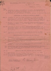
[a] Cohn Bros printed manilla envelope Handwritten caption' Memo of how P/N [payments taken from Smith Barham, Spain Echuca, Giblett Wychitella, . [b] Documents pertaining to above enclosed. - One page has a list of Promissory notes dated from 1933 to 1935 -written at the top is the name Maxwell Edmond Gibbett , there is a form regarding a 100 pound loan with Miss S.A. Spain showing repayment dates and interest starting 1934 other loan forms relate to Thomas Daniel Smith and Giblet Railway hotel Wychitellabendigo, industry, cohn bros brewery -
 Bendigo Historical Society Inc.
Document - MISS G ALICE JONES COLLECTION: ACCOUNT
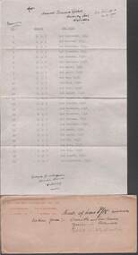
New Balaclava Gold Mining Syndicate Ltd. To Miss G. Alice Jones. Pink paper dated May 16, 17, June 1, 2, July 27, Aug 8, 11, 14, 28, 29, Sep 4 to Oct 5 and 10/11/1933. Re Reconstruction of Co., Alterations of Rules, new Manager & office, Sale of assets to trustee for new Company, and Agreement with Trustee for new Company. Total cost £10.10.0. "R?81 Del 10/11/33" written in the top left corner.the miss g alice jones collection - account, new balaclava gold mining syndicate ltd, mr leed, mr field -
 Bendigo Historical Society Inc.
Photograph - SOUTH NEW MOON MINE - EAGLEHAWK, 1935
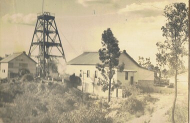
2 Photographs on a folded board. One black and white, one sepia. Both photographs of South New Moon Mine, Eaglehawk, taken from 2 different views. Written on board around the photos. Gold yield 257.498 ozs. Dividends $ 1.106.560.00. Leading mine on field 1901-05. Leading mine in state 1903. Operated 1871 to 1920's. Revived 1933 to 1941. The sepia photo on right side of cardboard says, 'Above photo taken 1935.' Written on back of one photo, A.Richardson, 29 Harrison Street, Bendigo.'eaglehawk, mine - south new moon., olive pell collection. south new moon mine -
 Melbourne Tram Museum
Drawing, Melbourne & Metropolitan Tramways Board (MMTB), "Explosive Factory Cordite Ave - Proposed Tramway Extension shown red", 1940's
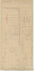
Drawing - red ink drawn on a print showing an extension to the single track, Maribyrnong tram line to run further into the Explosives Factory. Original print from the Commonwealth of Australia, Dept of Munitions, Factory Board drawing number W-1163 titled "Explosives - Munitions Supply Laboratories Proof at Rest - Maribyrnong" and dated April 1933. Marked in red ink is a "Explosive Factory Cordite Ave - Proposed Tramway Extension shown red". Not dated, possibly early 1940's. Also has pencil markings around the terminus showing an alternative loop.In blue pencil both edges on the rear "Cordite Ave" and in pencil on rear "Copy to Mr ?? to file"trams, tramways, footscray, maribyrnong, new tramway, explosives factory -
 Melbourne Tram Museum
Photograph - Black & White Photograph/s, mid 1930's?
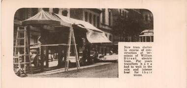
Black and white reproduction photograph of a newspaper item of the construction of the new William Street shelter at the terminus at Collins Street. undated. Has a W Class tram in the background. Rod Atkins advised by email 25/6/2019; Planning was knocked back in 1927 by the MCC - The Age 10/08/1927 page 16 - Trove But is in the Tram Shelter book C1930? in our collection. Pages 17 and 18! Article in TROVE The Argus 2/3/1933 Page 6. Port Melbourne council requesting MMTB to erect a shelter in Market Street at Collins Street.trams, tramways, william st, shelters, mmtb -
 Surrey Hills Historical Society Collection
Work on paper - Vertical file, Clota family
A vertical files containing the following information: 1. Research document re Antonio and Josepha Clota. Includes: a) photos from Lola Waring collection; profile of Antonio Clota in his role as President of the Café and Caterers Association of Victoria in ‘The Australian caterer’, August, 1933; b) notes regarding Clota businesses; some oral history from Lara Waring. 1.1.2017. Sourced from various internet sources including Trove, www.catalan.footprintsinAustralia.net and ‘The Australian caterer’ by Sue Barnett. (14 pages). N.B. Lola Waring donated copies of some of these photos to this collection. -
 Victorian Interpretive Projects Inc.
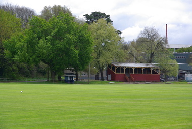
Photograph - Colour, Clare Gervasoni, White Flat Grandstand, 07/10/2012
In 1925 there was a group known as the White Flat Improvement Committee. The White Flat Sports Reserve was officially opened on 18 March 1925 at which time Sir Alexander Peacock said that 'a wonderful change had been brought about at White Flat , and those who had brought it about would have the gratification of knowing that they were providing inestimable pleasure for the children and young people.' In 1934 the grandstand was moved to White Flat from the defunct Buninyong Racing Club. Albert Edward (Sonny) Mark was a foundation member of the Golden Point Cricket Club in 1910/1911 and part of the first Premiership side. He was a prominent A grade player and committee member for many years, including being Treasurer of the Club from at least 1933/34 to 1938/39. He acted as Golden Point delegate to the Ballarat District Cricket Association from 1934 to 1938. Sonny served as a Member of the White Flat committee from 1932/1933 to 1948/1949. Every year from the year 1933 until the Club went into recess in 1942 he took the chair for the election of President at annual meetings, an honour now reserved for Life Members. The B.D.C.A. B Grade shield named in Sonny Mark's honour for his contribution to the Golden Point Cricket Club and also to Ballarat cricket . He was instrumental in having the Grandstand at White Flat constructed and it was named in his honour. (http://goldenpoint.cricketvictoria.com.au/lifemembers.html)Five digital photographs of the grandstand at the White Flat Oval, Ballarat. Known as the A.E. 'Sonny' Mark Stand, it was opened in May 1934. ballarat, white flat, white flat sports ground, hickman street, south street, armstong street, oval -
 Orbost & District Historical Society
certificate, Phillips, John, 2012
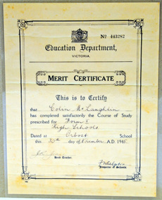
The original certificate was issued to Colin McLaughlin by the Education Department, Victoria on 30.11.1945. Colin Francis McLaughlin was born January 5, 1933 in Orbost and died May 2, 2008 in Ringwood. He was the son of Phillip Henry McLaughlin and Ethel Olive Morgan . This copy was produced by John Phillips for the Orbost Secondary College Centenary Celebration 28/29 April 2102.Orbost High School / Orbost Secondary College has played a significant part in the education of senior students in the Orbost district . It is the sole senior educational institution. This certificate is representative of its history.A laminated copy of a merit certificate presented to Colin McLaughlin No 443282 for Form !! Course of Study. 30.11.1945. It is signed by J.R.Jones (head teacher) and F. Whelpston (inspector of schools)On back : Produced by John Phillips for the Orbost Secondary College Centenary Celebration on Saturday 28th April and Sunday 29th April 2012certificate education orbost -
 Greensborough Historical Society
Memoir, Alan Partington et al, The Arrival and settlement of my family in Australia, by Alan Partington, 1830-1920
Alan Partington was born in Greensborough in 1908 and attended Greensborough Primary School. He worked on the family farm before becoming a policeman in 1933. He served with the police for 31 years. He writes about the activities of the Whatmough and Partington families in the Greensborough district. Reprinted from "Greensborough Primary School 2062, 1878-1980". Article written in 1980.6 p. typescriptpartington family, whatmough family, alan partington -
Tatura Irrigation & Wartime Camps Museum
Photograph - original, Kodak, Bob Bird Chemist, 1920's original
Original photograph of Bob Bird, son of H. E. S. Bird, chemist Shepparton. Later had pharmacy in Hogan Street, Tatura (1933-1939) Trevor LaPeyre, who had learned pharmacy from H. E. S. Bird took over from E. G. Bird. Jan LaPeyre later married Marge Bird.Original photograph of Mr Bob Bird Chemist. c 1930's.on back: Bob Bird, son of H. E. S. Bird, chemist of Shepparton bob bird, h. e. s. bird, trevor lapeyre, e. g. bird, jan lapeyre, marge bird, bird chemist shepparton -
Tatura Irrigation & Wartime Camps Museum
Photograph - copy, D. Clark, Bob Bird Chemist, 1920's original copy 1989
Copy of Original photograph of Bob Bird, son of H. E. S. Bird, chemist Shepparton. Later had pharmacy in Hogan Street, Tatura (1933-1939) Trevor LaPeyre, who had learned pharmacy from H. E. S. Bird took over from E. G. Bird. Jan LaPeyre later married Marge Bird.Copy of Original photograph of Mr Bob Bird Chemist. c 1930's. Original L0336on back: Bob Bird, son of H. E. S. Bird, chemist of Shepparton bob bird, h. e. s. bird, trevor lapeyre, e. g. bird, jan lapeyre, marge bird, bird chemist shepparton -
Tatura Irrigation & Wartime Camps Museum
Photograph - copy, D. Clark, Bob Bird Chemist, 1920's original 1989 copies
Copy of Original photograph of Bob Bird, son of H. E. S. Bird, chemist Shepparton. Later had pharmacy in Hogan Street, Tatura (1933-1939) Trevor LaPeyre, who had learned pharmacy from H. E. S. Bird took over from E. G. Bird. Jan LaPeyre later married Marge Bird.Copy of Original photograph of Mr Bob Bird Chemist. c 1930's. Original L0336. Black and white copy and enlarged photograph of original.on back: Bob Bird, son of H. E. S. Bird, chemist of Shepparton bob bird, h. e. s. bird, trevor lapeyre, e. g. bird, jan lapeyre, marge bird, bird chemist shepparton -
Clunes Museum
Financial record - ACCOUNT LEDGERS, NO.1 1943 - '66 NO.2 1967 - '86 NO.3 1986 - 1989
ROYAL VICTORIAN INSTITUTE FO THE BLIND. CLUNES AUXILIARY FORMED 1933. DISBANDED 1989. STREET STALLS, CONCERTS, TRADING TABLES, CASH DONATIONS AND ASSISTANCE OF LOCAL BUSINESS HOUSES, ALL THE LOCAL CHURCHES (EACH CHURCH RAN THEIR OWN STALL ON DAY OF ANNUAL FAIR) A BLIND REPRESENTATIVE ATTENDED THE ANNUAL MEETINGS AND ALWAYS PROVED AN INTERESTING SPEAKER.CLUNES AUXILIARY FOR THE BLIND NO.1 SMALL THICK BLACK, SOFT COVERED TREASURERS BOOK WORKS FROM BOTH FRONT AND BACK COVERS 1943 - 1967. NO.2 BLUE SOFT COVERED PENCRAFT CASH BOOK, TREASURERS BOOK 1967 - '86 NO.3 ORANGE SOFT COVER LEDGER, TREASURERS BOOK 1985 - 1989 R.V.I.Plocal history, books, documents, clunes blind auxiliary -
 National Wool Museum
Trophy, Blue Triangle Basketball Association 1931: Collins Bros Challenge Shield B Grade Teams
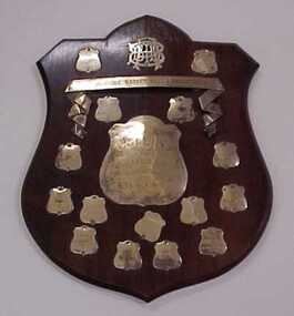
Acquired when "Classweave Industries" closed down.BLUE TRIANGLE BASKET BALL ASSOCIATION 1931 COLLINS/ BROS/ CHALLENGE SHIELD/ B GRADE TEAMS/ TO BE WON 4 TIMES 1931/ BRIGHT & HITCHCOCKS 1932/ VALLEY B 1933/ FEDERAL B 1937/ RS & S MILL 1938/ GEELONG GIRLS UTILITY CLUB 1941/ WANDERERS 1942/ DONAGHYS 1936/ NOBLE ST GIRLS CLUBtextile mills woollen mills textile mills - staff sporting teams, classweave industries pty ltd federal woollen mills ltd, sport, textile mills, woollen mills, textile mills - staff, sporting teams -
 The 5th/6th Battalion Royal Victoria Regiment Historical Collection
Award - Trophy, Military and Athletic Championships 3rd M.D, 1927
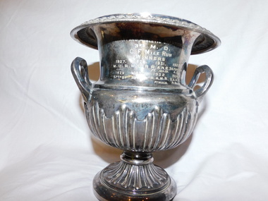
pre war Military district running trophyOrnate, silver trophy, similar in shape to a classic vase, with a riged surface and lip that rolls out from the open top Military and Athletic Championships 3RD M.D C.F. MILE RUN WINNERS 1927 MUR 1928 57TH BN 1929MUR 1930 39 BN 1931R.A.N.R PT MELB 1932 R.A.N.R PT MELB 1933 34 FRT COY A.E 1934 R.A.N.R. PT MELB 1935 R.A.N.R PT MELB 1937 M.U.R 1938 14TH BN 5/6 rvr, vsr, 3 md, trophy, m.u.r, r.a.n.r, 14th bn, 39th bn, 34 frt coy a.e -
 Warrnambool and District Historical Society Inc.
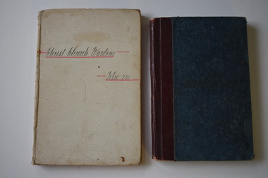
Administrative record - Cash Books, Christ Church Wardens Folio 781, 1930s
These two notebooks come from Christ Church in Warrnambool. One contains the cash transactions of the Christ Church wardens (Folio 78) with the National Bank of Australasia (1932-1938) and the other contains the financial transactions of the Christ Church Parochial Missionary Association, Warrnambool (1933-1940). The Anglican Christ Church in Warrnambool was opened in 1856 with the addition of the nave in 1860 and the square tower in 1882. These cash books are of historic interest as records of financial transactions of Christ Church in Warrnambool in the first half of the 20th century..1 A buff-coloured, hard cover notebook with handwriting on the front cover. The pages contain ruled black lines and printing and handwritten material in black and red ink. .2 A hard cover notebook with a blue cover with dark red leather binding. The pages contain printed red lines and handwritten material in black ink.Christ Church Parochial Missionary Association Warrnamboolchrist church warrnambool, christ church parochial missionary association -
 Tatura Irrigation & Wartime Camps Museum
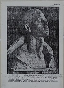
Photograph - copy, Wounded Soldier, 1940's
Sculpture made by Pte Bruno Simon V377556, a 30 year old internee who became a member of the CMF Employment Company. After Nazism came to Germany in 1933, Simon studied sculpture in Paris and Florence and then came to Australia. He was a Jewish internee allowed released from camp in 1942 and after a short period picking fruit joined the CMF Employment Co.Copy of a photograph of the head of an Australian soldier mounted on a foam backingphotograph, wounded soldier, bruno simon, sculpture, internment camp sculptors -
 Uniting Church Archives - Synod of Victoria
Photograph, Undated c.1949
Rev. Kolinio Saukuru was the grandson of the only survivor of the party led by Rev. Thomas Baker, which was massacred and eaten by a hill tribe in central Fiji in 1867. In 1933 he was appointed by the Methodist Mission as a catechist to work among the aborigines of North Australia. He was accepted for the ministry in 1939, and was ordained at Croker Island in 1945. During WWII he was in charge of the Yirrkala Mission Station. B & W head and shoulders studio portrait of the Rev. Kolinio Saukuru, in postcard format.Rev. Kolinio Saukurukolinio saukuru, methodist, minister, thomas baker, fiji, croker island, aboriginies, mission -
 Uniting Church Archives - Synod of Victoria
Photograph, Undated c.1911
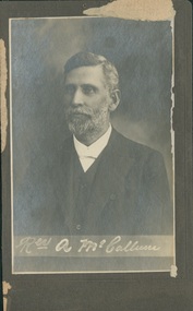
Reverend Alexander McCallum DD was born in 1866 and served at Shepparton, Melbourne Brunswick, Oakleigh, Ararat, Geelong Yarra Street, Geelong West, Melbourne Brunswick, New Town, Warrnambool, Wangaratta, Melbourne Central Mission. He was Secretary-General 1917-1920 and President-General 1920-1923, Secretary of Conference 1910 and President of Conference 1911. He died in 1933B & W head and shoulders studio portrait of the Rev. Alexander McCallum, mounted on grey card.rev alexander mccallum, methodist, minister, president of conference -
 Surrey Hills Historical Society Collection
Photograph, Our Holy Redeemer School students, circa 1915, 1915
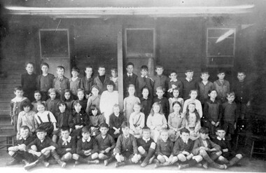
Date is approximate. In 1904 Fr George Robinson had a weatherboard school hall erected beside Our Holy Redeemer Church, which had opened in 1902. The hall was opened on 20 November 1904 by Archbishop Thomas Carr and the following January the Sisters of St Joseph took charge of the school. Fr David Gleeson was parish priest from 1911-1933.Black and white photo of students of Our Holy Redeemer School in c1915. There are 50 students - 29 boys and 21 girls taken on the veranda of a building with a corrugated iron roof. education, primary education, children, our holy redeemer primary school, 1915, sisters of st joseph, fr david gleeson -
 Vision Australia
Image
Sister Elizabeth Lindsey worked at the RVIB Nursery from it's inception in 1933. During this time, she took photographs of the children, whom she had care of, documenting their life at RVIB as well as the wartime displacement to Olinda when the army took over the St Kilda Road building. Adopting one of her orphan charges, Sister Lindsay left RVIB in 1945. 58 digital files of photographs.rvib nursery, monty james, angelo harris, jimmy schultz, ian cooper, bertie glenister, alan crotty, harry parsons, shirley devine, helen boyd, alan woods, joan morice, david ditchfield, elaine dean (later leahy), cynthia walker, matron jessie morrison, barbara spencer, mae rita, margaret russell, jessie rita, pearl tropman, margaret seary, heather stewart, mrs jenkins, gwen baird, hilda gammon, bobby bolter, judith king, joan ryan, olinda -
 Wodonga & District Historical Society Inc
Administrative record - Bound ledger from the J.Mann & Sons General Store in Wodonga from 1930 to 1932, CASH BOOK
The ledger is part of the 'Mann' collection and was used for accounting records in the J. Mann & Sons General Store in Wodonga from July 1930 to January 1932. It is one of three bound ledgers from the J. Mann & Sons General Store and the other two date from 1932-1933 and 1933-1934. J. Mann and Sons was first established as a farm produce store in 1921. The range of products was extended in the 1930s and included groceries and hardware, as well as the first petrol bowser in Wodonga outside the store. After WWII, the premises were extended and the range of products continued to increase. In the 1960s the Mann Family opened a new supermarket in Wodonga, in addition to the hardware business, providing steel, plumbing and industrial supplies, and they employed over 100 people at one stage. With changes in the retail industry, the Mann Family sold the main hardware business to Bunnings and the steel and rural produce business to the Kelly brothers in 2006. The ledger has local significance due to its use in the J. Mann & Sons General Store in High St, Wodonga and the association with the prominent Mann family in Wodonga.Bound ledger with a deteriorated light brown leather and green textile cover over thick cardboard. Red leather band on the spine with "CASH BOOK" written in gold letters and a decorative gold border at the top and bottom edges. Lined paper in the interior with columns for accounting in 1930-1932.Paper label attached to the inside of the front cover: "ANDREW JACK, DYSON & Co. / PTY. LTD. /WHOLESALE STATIONERS / 23452 / FOR REPEAT ORDER QUOTE ABOVE No. / 594-610 LONSDALE ST. / MELBOURNE" mann, j. mann, wodonga, high st, accounting, ledger, cash book, commerce, business, general store, j. mann & sons -
 Bendigo Historical Society Inc.
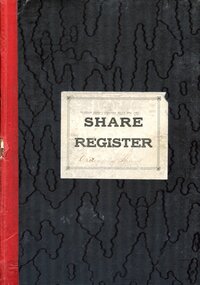
Book - HANRO COLLECTION: SHARE REGISTER 1933 - 1950
Share Register with a black patterned cover and red cloth tape spine. Entries from 1933 to 1950. Label on the front has Hanro (Aust) Knitting Mills Pty Ltd, Share Register (printed) and Ordinary Shares (handwritten). Index at the front of book. name, address and occupation are listed at the top of the double page. Columns for date, particulars, No of Transfer, Distinctive Nos - From and To, DR, Cr, Balance of Shares Held, Distinctive Nos Held - From and To, Dr - Date and Amount, and Cr - Date and Amount. Book only partly used. Each double page is numbered.hanro, clothing, share register, hanro collection - share register 1933 - 1950, mary anderson, eugen bloch, john raeburn balmer, katie bloch, estate sydney raeburn balmer, consortium hanro, william crowley, william r cook, favoloro's investment co pty ltd, fiduciaire generale sa, alexander lewis goldie, mabel gittins, albert vivian gray, chas handschin (dec'd), alice handschin, catherine hunter, william dill hunter, annie chambers hunter, mary elizabeth hunter, frank harris, wiliam roy hiscock, herbert keck, harry francis longstaff, george victor lansell, edith lansell, audrey e lansell, marie g lansell, patrica h lansell, jane t lyons, lillie goudie mcgregor, philip henry mckean, alan t miller, william bowman hanna neill, evelyn adrienne neill, elizabeth neill, edith fortuna victoria norbury, r a rankin, w h russell, w j stephens, j smalley balmer cook, john jepson stanistreet, kenneth smalley, johnathon smalley, royal james v stilwell, william oliver stephens, william wright -
 Bendigo Historical Society Inc.
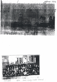
Photograph - LONG GULLY HISTORY GROUP COLLECTION: DON MINE & LONG GULLY STATE SCHOOL
Copy of a black and white photo of the Don Mine, approx 1934. Written above the photo is - This mine is similar to the New Carshalton Mine off Sparrowhawk Road, Long Gully. Dorrie Crossley's Father Ben Williams was the manager. this is the Don Mine off Top end Sparrowhawk Road, Long Gully. Date above the photo January 7, 1997. Photo (not a very clear one) shows the poppet legs, chimney and some buildings. Below is a photo of the 1 & 2 Class children from the Long Gully State SChool 1933. The children are sitting or standing in front of a brick building.bendigo, history, long gully history group, the long gully history group - don mine, new carshalton mine, dorrie crossley, ben williams, long gully state school photo 1933