Showing 3431 items matching "distance"
-
 Frankston RSL Sub Branch
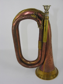
Bugle, 1911
The bugle was most likely used in the First World War for ceremonial and military operational functions. Bugles were an effective means of passing fixed messages and times over the noise and distance of battles and battlefields. Henry Potter & Co was a well known manufacturer of military bugles for the First World War. Military copper bugle with brass trim and silver (?) mouthpiece with brass retaining chain. inscribed "Henry Potter & Co" "38 West Street, Charing X Road, London 1911"world war one, ww1, brass, musical instrument, bugle, henry potter -
 Flagstaff Hill Maritime Museum and Village
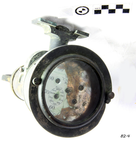
Instrument - Ship Log, first patented 1878
Ship's log register or recorder, used to determine the distance a ship travels and the speed it is traveling. It would be fixed to the rail (taffrail) at stern of the ship and attached to the log rotor that would be towed behind the ship. The Cherub design was one of the first to have the register placed on the ship instead of with the rotor in the water.Ship's taffrail log register, recovered from the tug "Melbourne". Dial and bracket, brass. "Patented and made in England". Parts of words 'Walker's Cherub Log, Mark II" are visible. 2 dials marked in 100's and 10's "Patented and made in England". Parts of words "W" (Walker) "CH" (CHERUB) "Ma" (Mark III) flagstaff hill, warrnambool, shipwrecked coast, flagstaff hill maritime museum, maritime museum, shipwreck coast, flagstaff hill maritime village, great ocean road, ship's log register, log register, log dial, t walker, thomas walker, cherub log -
 Stawell Historical Society Inc
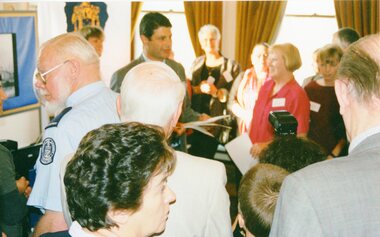
Photograph, Announcement of Local History Grants Program Round Three 2002, 2002
7141 John Brumby at the announcement in the distance. 7141-1 John Brumby speaking at the announcement. 7141-2 John Brumby speaking at the announcement. 7141-3 Large crowd of people with John Brumby in middle of crowd. 7141-4 Side on of John Brumby talking with microphone to his right.Five colour photographs of the Announcement of the Grantsbiarri -
 Stawell Historical Society Inc
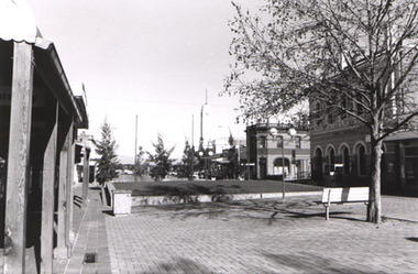
Photograph, Gold Reef Mall Stawell looking West from area in front of L.C. Langsford's Pharmacy
Gold Reef Mall Stawell looking West from area in front of L.C. langsford's Pharmacy showing grassed area beside Wimmera Street intersection. Post Office on right old Bank/Chemist building corner of Main and Wimmera Streets near centre and Town Hall in distance.stawell streetscape -
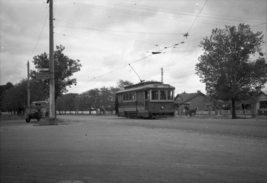
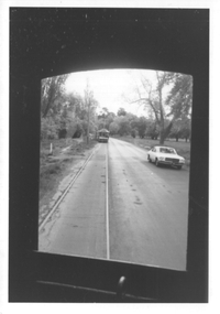 Ballarat Tramway Museum
Photograph - View of Wendouree Parade north end, c1977
Photograph from the window of a tram (possibly No. 28) looking along the BTPS track from St Aidans Drive with another tramcar in the distance. Shows the roadside nature of gardens area at the time - long grass and before the construction of a gutter and paths. Possibly taken at the same time as item 9642.Yields information about Wendouree Parade near St Aidans Drive.Black and white print on Kodak paper.tramcars, trams, btps, tram 26, tram 28, st aidans drive, wendouree parade -
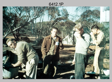 Bendigo Military Museum
Photograph - Royal Australian Survey Corps Surveyors in the Field – Victoria, 1956 - 1958
This is a set of two photographs of surveyors and support staff in the field undertaking tasks in Victoria 1956 – 1958. The surveyors were employed in the establishment of mapping and geodetic control. In this era surveyors used theodolites to observe horizontal and vertical angles and chains to measure base line distances between survey stations. This is a set of 23 photographs of surveyors and support staff in the field undertaking duties in Victoria 1956 – 1958. The photographs were printed on photographic paper and are part of the Army Survey Regiment’s Collection. The photographs were scanned at 300 dpi. .1) - Photo, colour, 1956. Surveyors enjoying a tea break. L to R: Tom Gilbert (cook), Barry Broad, Tony Slattery, John Van De Graff. Taken at Boonoonar, a locality south of Mildura. .2) - Photo, colour, 1958. Surveyors taking a break from driving. L to R: Leo Bub, Bob Thompson. Taken at Puckapunyal..1P to .2P annotated on back – personnel names, the year and the location. royal australian survey corps, rasvy, army survey regiment, asr, army svy regt, fortuna, surveying -
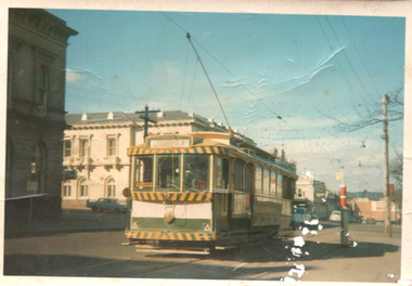 Ballarat Tramway Museum
Photograph - Tram 33 City Centre, Maureen van Rooy, c1971
Photograph shows Ballarat No. 33 at the City Centre stop, c1971. Tram has the destination of Lydiard St North and has a one man sign in the back cabin. The short tram stop pole is alongside. In the background is the ANZ bank, the Post Office and in the far distance the Big W store.Yields infomation about tram 33 and the City Centre stop.Colour print with plain back.tramcars, tramways, sturt st, lydiard st, tram 33, post office, city centre -
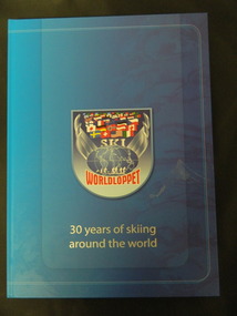 Kiewa Valley Historical Society
Book - Cross Country Skiing x2, Worldloppet - 30 Years of Skiing Around the World, 2007
The Worldloppet is a skiing race held throughout the world for cross country skiers. American Tony Wise conceived the idea of bringing together long distance skiers together. 14 ski marathons held in 4 continents (Europe, North America, Australia and Asia) with over 90,000 skiers each year.Falls Creek is on the Bogong High Plains at the top of the Kiewa Valley. Falls Creek held the first Kangaroo Hoppet in 1979 over a distance of 21 km with 80 participants. In 1995 a record 1588 participants took part. They received membership of the Worldloppet in 1991 holding the event on the last Saturday of August and haven't had to cancel the event. Two copies of a blue hard covered book with 167 pages consisting of an index (Kangaroo Hoppet page 54), information on 30 years of (cross country) skiing around the world with colored photos. cross country skiing; worldloppet; falls creek -
 Glen Eira Historical Society
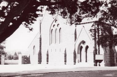
Photograph - St. Mary’s Church, Caulfield
Three photographs and one photocopied photograph of St. Mary’s Anglican Church Caulfield. All are undated and photographers are unknown. The first has paddocks in the foreground with the church in the distance. Also included are three lithographs of an architectural sketch of the proposed church from Illustrated Australian News 1870-1874, page 148.st. mary’s church, caulfield, reed and barnes, architects, caulfield, illustrated australian news -
 Moorabbin Air Museum
Photograph (item) - Southern Cross Fokker Tri Motor flown by Sir Charles Kingsford Smith
The Southern Cross is a Fokker F.VIIb/3m trimotor monoplane that was flown by Australian aviator Charles Kingsford Smith, Charles Ulm, Harry Lyon and James Warner in the first-ever trans-Pacific flight to Australia from the mainland United States, a distance of about 11,670 kilometres (7,250 mi), in 1928. -
 Bendigo Military Museum
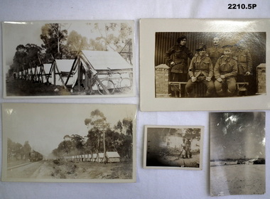
Photograph - PHOTOGRAPHS WW1, WW1
Photos were in the collection relating to Thomas Henry Whyte No 1936 AIF. Refer Cat No 2212.6 for his service history. .1) Black and White Row of tents with bicycle and clothing in foreground. .2) Black and White Group of five soldiers unnamed postcard format. .3) Black and White Row of tents Steam Train on LHS .4) Black and White Soldier, boy and young child .5) Black and White Buildings in middle distance. Snowphotographs, 38th, england -
 Ringwood and District Historical Society
Map, Plan of Country Lands in the Parishes of Nunawading Ringwood and Scoresby - circa 1855
Blueprint copy of Survey Map detailing original Selectors' names and property locations. List of Parish map references including property bearings, distances in Links, and markings on trees. Descriptive remarks include areas marked "Farmer's Common", "Poor soil thickly/moderately timbered with stringy bark", and location of water and firewood reserves."Surveyed and plotted by N.M. Bickford, Superintendant of Mr. Hodgkinson's Field Party". "The land comprised in this survey is of inferior quality, moderately undulating, and thickly wooded. It is watered by Dandenong Creek and Deep Creek." Inset map showing location of (*proposed) cemetery on southern corner of Lillydale Road from Melbourne and Sawmill Road, later Mount Dandenong Road. (*Cemetery did not eventuate.) -
 Bendigo Historical Society Inc.
Photograph - CEMETERY - BENDIGO - MINERS' CEMETERY
Photograph - 'AMBROTYPE' which is imaging a negative on glass backed by a dark surface. A photo of graveyard with picket fences around grave sites, three men standing in the background, one building in the distance. Photo is in a leather bound box, two clips, open it up, has red velvet in case, glass over ambrotype photo..place, cemetery, cemetery, cemetery. bendigo area. ambrotype photo. -
 Whitehorse Historical Society Inc.
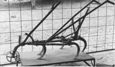
Machine - Scarifier, 1900- 1940
Lever tyned walking scarifier, pulled by a horse. Designed for use in market gardens and is adjustable so the distance between rows may be varied. These items were on sale between C1900 and C1940 .Its lightweight construction suggests that this exhibits a late rather than an early model. Similar to a horse hoe scuffer used in America.rural industry, agriculture -
 Ballarat Tramway Museum
Negative, Wal Jack, late 1930's
Yields information about Ballarat 's tram operations and the Victoria St terminus.Negative and Digital image of the Wal Jack Ballarat Negative file of No. 20 at the Victoria St terminus. A crewman is about to step from the car. In the distance is a horse drawn cart delivering - possibly bread or milk. The tram has the destination of Gardens via St west. The trolley pole is yet to be turned. Shows the overhead arrangements. trams, tramways, victoria st, horse drawn vehicle, tram 20 -
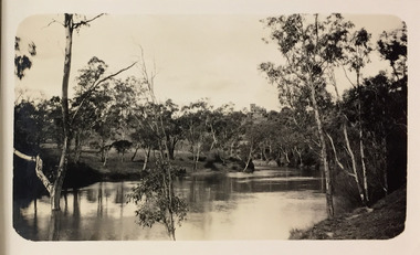 Kew Historical Society Inc
Photograph - Yarra River, Kew, 1925
Henry Beater Christian (1886-1962) , was a descendant of one of the earliest settler families in Kew. Employed at the Kew Asylum as a 'public servant', he was a skilled amateur photographer, photographing numerous scenes in Kew and on his travels around Victoria. The majority of his photographs date from 1916 to 1929. His finest photographs are housed in two photograph albums. Digital copy of a photograph from page 3 of the 47-page photograph album containing 261 gelatinous silver images, loaned by Diane Washfold with permission given to digitise and hold a copy in our collection. A photograph of a stretch of the Yarra River at Kew. In the distance rises J Lewis Carnegie's mansion 'Carnsworth' in Stawell Street."Yarra Rvr / Kew / 1925"henry beater christian (1886-1962), landscape photography, kew (vic.) — yarra river, christian-washfold collection, photograph albums, carnsworth -
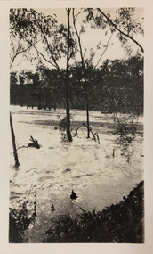 Kew Historical Society Inc
Photograph - Flood, Zig-Zag, Kew, 1924
Henry Beater Christian (1886-1962) , was a descendant of one of the earliest settler families in Kew. Employed at the Kew Asylum as a 'public servant', he was a skilled amateur photographer, photographing numerous scenes in Kew and on his travels around Victoria. The majority of his photographs date from 1916 to 1929. His finest photographs are housed in two photograph albums. Digital copy of a photograph from page 5 of the 47-page photograph album containing 261 gelatinous silver images, loaned by Diane Washfold with permission given to digitise and hold a copy in our collection. This is a photograph of the river at Kew during a flood in January 1924. A section of the Zig-Zag Bridge can be seen in the distance. "Flood / Zig-Zag Kew / 1.24"henry beater christian (1886-1962), landscape photography, kew (vic.) — yarra river, christian-washfold collection, photograph albums, floods -- yarra river -- kew (vic.), zig-zag bridge -
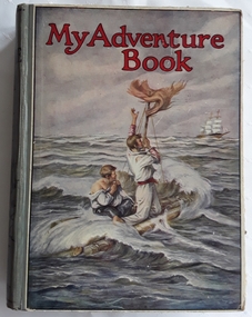 Mont De Lancey
Book, John F. Shaw and Co. Ltd, My Adventure Book, c.1920
A collection of adventure stories for children.A large hardcover with the title printed in red at the top, My Adventure Book of stories for children by multiple authors, with a coloured illustration on the front cover of two men floating on a raft at sea waving to a sailing ship in the distance. The spine has the title, publisher and a lined drawing of a man on a horse. It is illustrated in monochrome and also colour plates. fictionA collection of adventure stories for children.adventure stories, children's fiction -
 Melbourne Tram Museum
Photograph - Black and White photograph, 1920s
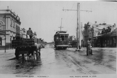
.1 - Black and White photo of NMETL No. 1 (U class, letter M, Maribyrnong River) westbound in Racecourse Road Flemington, at the intersection with Wellington and Pridham St. Note the centre poles. The Railway over bridge is in the distance. c1920. A horse drawn cart with hay or straw is alongside while two ladies cross the road.On rear in ink "Photo David Bowman Coll."trams, tramways, newmarket, racecourse road, flemington, u class, tram 1, nmeltl -
 Melbourne Tram Museum
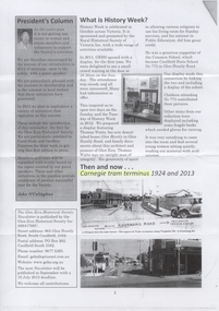
Document - Photocopy, Keith Stodden, "Carnegie tram terminus 1924 and 2013", Mar. 2013
Photocopy from the Glen Eira Historical Society, March? 2013 Newsletter (page 2) with a photo of the Carnegie tram terminus in 1924 and 2013. Features photo including a straight sill four wheel tramcar advertising a real estate sale and distance to Carnegie Railway station in 1924, and Z 173 in 2013 at the same location.trams, tramways, carnegie, truganini rd, tram 173 -
 Bendigo Historical Society Inc.
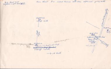
Document - MINING REPORTS - CALEB THOMAS PLANS
Copy of Caleb Thomas Plan. Sheet No IV, dated 19/1/1885. Mines mentioned are: St Mungo , Sadowa, Ellenborough and the Belmont & Saxby. Also mentioned are Shaft No 38 and Shaft No 40A. Distances between each shaft in yards or feet, number of compartments and ounces of gold. Document is part of the Albert Richardson Collection. document, gold, mining reports, mining reports, caleb thomas plans, st mungo, sadowa, ellenborough, belmont & saxby -
 Lakes Entrance Historical Society
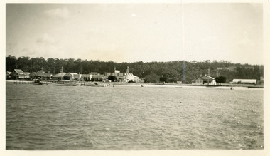
Photograph - Guesthouse/Businesses Esplanade Lakes Entrance, 1930c
Black and white photograph of the Esplanade, showing buildings including Kiaora House, Heyfield Guesthouse, Kents Garage, and vacant blocks either side of Miss Bertha Hansen's guest house. Boats at jetty on edge of Cunninghame Arm. Kalimna escarpment in the distance background. Photo taken from the middle of the lake. Lakes Entrance Victoriaguesthouses, retail trade, boats and boating, waterfront, jetties -
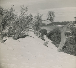 Lakes Entrance Historical Society
Photograph - Sand hummocks c1952 Lakes Entrance Victoria, L Carpenter, 1952 c
sand hummocks showing drifting sand overwhelming a stand of coastal banksia trees.Black and white photograph of sand hummocks showing drifting sand overwhelming a stand of coastal banksia trees. Part of western end of township across Cunninghame Arm in distance Lakes Entrance Victoria. Also three black and white photographs showing sandrifts on hummocks overwhelming coastal banksia trees and other vegetation . c1952sand dunes, vegetation, environment -
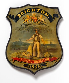 Bayside Gallery - Bayside City Council Art & Heritage Collection
Plaque - Escutcheon, Brighton Coat of Arms, 1858
When Brighton was first incorporated as a borough in 1859, the first seal and coat of arms of the municipality depicted a market gardener. Spade in one hand and fruit in the other, the gardener is surrounded by a cornucopia of produce, a ploughman toiling the field behind him, and a mill in the distance. It is underscored by the motto ‘By their fruits ye shall know them’.Oil paint on metal on shaped wood shield, depicting a figure of a standing male pioneer holding a spade in one hand and fruit in the other. A fruit tree directly behind him, two pineapples to the right and a cornucopia bearing fruit to the left. Behind the pioneer are depictions of the sea with a ship, a farmer with a horse ploughing a field, a steam train, and a windmill. A black banner at the top of the shield has inscription BRIGHTON which sits above the Royal Coat of Arms. A red banner at the bottom has Brighton's motto 'FRUCTU NOSCITUR' which translates to ‘By their fruits ye shall know them’. Another black banner underneath: 1858.escutcheon, coat of arms, brighton, fructu noscitur, bayside, shield, heraldry, borough of brighton, market gardener, windmill, train, farmer -
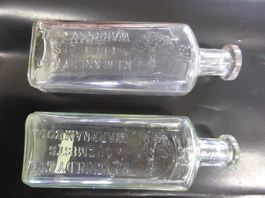 Warrnambool and District Historical Society Inc.
Bottle, R F Kennedy & Co, Early 20th century
These bottles were used in the pharmacy of R.F.Kennedy and Co. of Warrnambool. Richard Frank Kennedy (1826-1903) was born in England and came to Warrnambool in the early 1880s. He established a pharmacy in Timor Street. This was a retail, wholesale and manufacturing business. In 1891 Kennedy erected a new building and his business there was described as one of the most elegant and best-stocked chemist’s shops in Victoria. Kennedy was active in Warrnambool community affairs and was a foundation member of the Warrnambool Bowls Club, being its first Vice-President and an early President. After his death the pharmacy business continued, trading as ‘R.F.Kennedy & Co.’ Richard Frank Kennedy was one of the most significant businessmen in Warrnambool in the late 19th century. The products of his pharmacy wee distributed all over Victoria and beyond. His lighthouse logo was well-known. These bottles are good examples of those used in the Kennedy business. These two identical bottles are made of clear glass. They have rectangular-shaped bodies with rounded edges, circular-shaped necks and moulded circular tops with openings. One has a glass stopper. The sides of the bottles have the Kennedy logo of a lighthouse on a rocky cliff on the coastline with ships in the distance and the name of the chemist. There is some discoloration inside one of the bottles. ‘2/3 vi’ ‘R.F.Kennedy & Co. Chemists Warrnambool’ ‘M’ r.f. kennedy, warrnambool chemist, chemists in warrnambool, history of warrnambool -
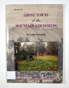 Marysville & District Historical Society
Book - Paperback book, Ghost Towns of the Mountain Goldfields, 1999
Ghost towns of the mountain goldfields in VictoriaPaperback. Cover has a drawing depicting horses, both ridden and pack, walking along a forest track on their way to a small town. There are heavily forested mountains in the distance. Overlaid onto the drawing is a modern photograph of an old stone building. In the foreground is a green timber building with a water tank and verandah. It is all set in the clearing in the middle of a forest.Stamp of the Marysville & District Historical Society Inc / P.O. Box 22 / Marysville 3779 Also the inscription: To Alma / Thanks for your help / Signature / LS / November 1999gold, gold mining, gold town, ghost town, victoria, australia, history -
 Federation University Historical Collection
Photograph - Colour, ANZAC Dawn Remembrance During the Covid-19 Pandemic, 2020, 25/04/2020
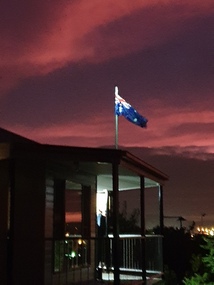
On 12 January, the World Health Organization (WHO) confirmed that a novel coronavirus was the cause of a respiratory illness in a cluster of people in Wuhan City, Hubei Province, China, who had initially come to the attention of the WHO on 31 December 2019. On 3 March, the Reserve Bank of Australia became the first central bank to cut interest rates in response to the outbreak. Official interest rates were cut by 0.25% (25 base points) to a record low of 0.5%. On 12 March, the Federal Government announced a A$17.6 billion stimulus package, the first since the 2008 GFC. he package consists of multiple parts, a one-off A$750 payment to around 6.5 million welfare recipients as early as 31 March 2020, small business assistance with 700,000 grants up to $25,000 and a 50% wage subsidy for 120,000 apprenticies or trainees for up to 9 months, 1 billion to support economically impacted sectors, regions and communities, and $700 million to increase tax write off and $3.2 billion to support short-term small and medium-sized business investment. On 16 March, Premier Dan Andrews and Minister for Health Jenny Mikakos declared a state of emergency for Victoria for at least four weeks. On 19 March, the Reserve Bank again cut interest rates by a further 0.25% to 0.25%, the lowest in Australian history. On 22 March, the government announced a second stimulus package of A$66bn, increasing the amount of total financial package offered to A$89bn. This included several new measures like doubling income support for individuals on Jobseeker's allowance, granting A$100,000 to small and medium-sized businesses and A$715 million to Australian airports and airlines. It also allowed individuals affected by the outbreak to access up to A$10,000 of their superannuation during 2019–2020 and also being able to take an additional same amount for the next year. on the same day Victorian Premier Daniel Andrews announced on 22 March that the state will bring the school holiday forwards to 24 March from 27 March. On 30 March, the Australian Federal Government announced a $130 billion "JobKeeper" wage subsidy program offering to pay employers up to $1500 a fortnight per full-time, part-time or casual employee that has worked for that business for over a year. For a business to be eligible, they must have lost 30% of turnover after 1 March of annual revenue up to and including $1 billion. For businesses with a revenue of over $1 billion, turnover must have decreased by 50%. Businesses are then required by law to pay the subsidy to their staff, in lieu of their usual wages. This response came after the enormous job losses seen just a week prior when an estimated 1 million Australians lost their jobs. This massive loss in jobs caused the myGov website to crash and lines out of Centrelink offices to run hundreds of metres long.The program was backdated to 1 March, to aim at reemploying the many people who had just lost their jobs in the weeks before. Businesses would receive the JobKeeper subsidy for six months. On 2 April, the number of cases in Victoria exceeded 1,000, including over 100 healthcare workers. On 5 April, New South Wales Police launched a criminal investigation into whether the operator of Ruby Princess, Carnival Australia, broke the Biosecurity Act 2015 (Cwth) and New South Wales state laws, by deliberately concealing COVID-19 cases. On 6 April, the Department of Health revealed that 2,432 people recovered from the infection as the federal government started reporting recovery statistics. This is more than a third from the official number reported so far, Deputy Chief Medical Officer Professor Paul Kelly stating, "I think it is important. Firstly it really reinforces that message, which is a true one, that most people who get this disease do recover”. The day before, at 3pm, it was announced that 2,315 of the 5,687 confirmed coronavirus cases had recovered. May 2020 - An outbreak in Victoria at a meatworks that was later revealed to be Cedar Meats was announced on 02 May with eight cases. By 8 May, the cluster of cases linked to Cedar Meats in Victoria was 71, consisting of at least 57 workers and 13 close contacts, including a nurse, aged care worker and high school student. The number had increased to 75 by 9 May, 88 by 13 May, and 90 by 14 May. On 9 May, two Victorian cases were announced to be related to McDonald's Fawkner. By 18 May, this had increased to 12 cases, and on that day it was revealed that a delivery driver had tested positive, prompting the closing for cleaning of 12 more McDonald's locations: Melton East, Laverton North, Yallambie, Taylors Lakes, Campbellfield, Sunbury, Hoppers Crossing, Riverdale Village, Sandown, Calder Highway Northbound/Outbound, Calder Highway Southbound/Inbound, and BP Rockbank Service Centre Outbound. On 15 May, South Australia became the second jurisdiction, after the ACT, to be free of any active cases, however on 26 May, a woman returning from overseas who was granted exemption into South Australia from her hotel quarantine in Victoria tested positive for COVID-19. This was the first new case in 19 days for the state.[101] On 4 June, it was announced that the woman had recovered and the state was free of any active cases once again.[102] On 17 May, Victoria announced two further business sites had been shut down due to a suspected case at each. Domino's Pizza in Fairfield has been shut for two weeks, and mattress manufacturer The Comfort Group in Deer Park was closed from Friday 15 May to at least Wednesday 20 May. On 6 June, both New South Wales and Victoria reported no new cases for the previous 24 hours, with only Queensland and Western Australia reporting one new case each, the lowest national total since February. Western Australia also announced two old cases. However, the new case in Queensland was linked to the Rydges on Swanston cluster in Melbourne when a man who travelled from Melbourne to Brisbane on Virgin flight VA313 on 1 June tested positive.Colour photographs of an ANZAC dawn remembrance from Armstrong Street South, Ballarat looking East towards Mount Warrenheip. Due to the Covid-19 Pandemic and associated social distancing requirements regular ANZAC Day services and marches could not be held. People were encouraged to remember from their driveways at dawn on 25 April 2020. covid-19, corona virus, pandemic, social distancing, anzac day driveway remembrance, dawn, australian flag, mount warrenheip -
Frankston RSL Sub Branch
Magnifier, Map Reading
A small pocket size folding magnifier used for enlarging detail when reading maps or examining aerial photographs complete with a leather storage pouch. Manufactured of brass by Casartelli of Manchester, England. When unfolded this forms a "U" shape with the glass lens positioned conveniently for map viewing and the base can be used to measure scaled distances.This item is stamped "CASARTELLI, MANCHESTER" and has 1/4, 1/2 and 1 inch markings. -
 Flagstaff Hill Maritime Museum and Village
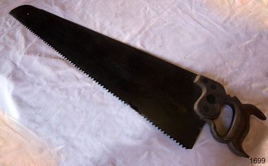
Saw
Handsaw with taper ground blade. Handle entirely enclosed and slotted to take heel of blade which is set in place with four rivets, one being longer and depicting kangaroo trademark. Handle elaborately carved with fishtail and decorative curves short distance from toe is a small notch or nib. RobtSorby Sheffield and a kangaroo stamped on bladeflagstaff hill, warrnambool, shipwrecked-coast, flagstaff-hill, flagstaff-hill-maritime-museum, maritime-museum, shipwreck-coast, flagstaff-hill-maritime-village, handsaw, robtsorby sheffield, kangaroo trademark -
 Bendigo Historical Society Inc.
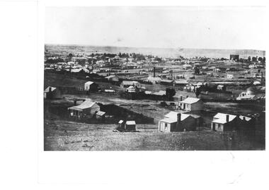
Photograph - VIEW OF MINER'S COTTAGES WITH KNIPES CASTLE IN BACKGROUND
Black and white photograph. Landscape view overlooking many weatherboard miner's cottages, brick house and more substantial buildings in background. Knipes Castle in background R. Mine with chimney and poppet legs in centre middle distance. Chimney at far R centre. Inscriptions: on back - 'MP 216', 'Historical Society of Victoria, Bendigo Branch'.place