Showing 4603 items
matching historical maps
-
 Eltham District Historical Society Inc
Photograph - Postcard, Rose Stereograph Company, View at Hurstbridge, Vic, c.1925
Rose Series Postcard P. 4341 “View at Hurstbridge, Vic.” Picnickers enjoying a Sunday outing near the Wattle Valley Estate at Hurstbridge. Copied from brochure "Wattle Valley Estate". It is believed the picture is taken at the northwest corner of the intersection of Wattletree Road and Hurstbridge-Arthurs Creek Road looking southeast towards the township (most likely where the house is located on the property of what is today No. 2 Wattletree Road)- https://goo.gl/maps/VDorwCe1rJJUapjE6 According to a comment by Jean Verso (via @nillumbikcouncil FB page 3 Jan 2020) - "This view is from Wattle Tree Road with Haleys Gully Road to the right and across the creek to William Gray's nursery at Allwood. The building to the far left looks like Dorset House. The building on the left in the middle distance is still there today and has been used for storage and as a stable/tack room for a number of years." The Wattle Valley Estate was first advertised in August 1925 as weekend building allotments by the Greater Melbourne Land and Development Company. Advertised from £28.10.0 or £60 per block. In August 1926, 30 picked allotments of 60x150 feet were put up for auction Saturday August 14, 1926 with frontages to Valley View Road and Fawkner Crescent advertised in the “Heart of the Glorious Wattle Country” and “Within 15 Minutes of the Newly Electrified Railway Station”. The Advertiser on August 13, 1926 in an article promoting the auction stated “the estate is regarded as one of the best in the district, and will be sold practically without reserve.” It is noted that an advertisement running in The Argus February 22, 1951 offered the remaining 16 blocks for sale at £12.10.0 or £200 the lot. By March 7, the remaining blocks were advertised at £17.10.0 The Wattle Valley Estate took over 20 years to sell and then people could not build on them Cross Ref SEPP_1057, “Popular Picnicing at Hurstbridge” rcopied from Wattle Valley estate sales brochure.Digital file only Postcards scanned from the collection of Michael Aitken on loan to EDHS, 13 Feb 20181925, dorset house, exhibition yprl 2019-12, fawkner crescent, haleys gully road, hurstbridge, hurstbridge-arthurs creek road, michael aitken collection, picnic, postcards, rose stereograph company, shire of eltham pioneers photograph collection, valley view road, wattle valley estate, wattletree road -
 Orbost & District Historical Society
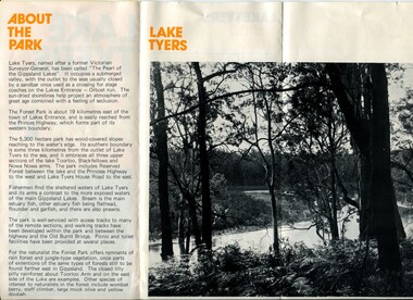
pamphlet, Lake Tyers Forest Park, 1960's
This pamphlet would have been produced as a tourist guide to East Gippsland.This item is a useful reference tool.A three fold glossy, pamphlet titled"Lake Tyers Forest Park". It contains information, a map and black / white photographs of Lake Tyers Park. Print colours are brown, white, yellow and black.pamphlet lake tyers-forest-park -
 Orbost & District Historical Society
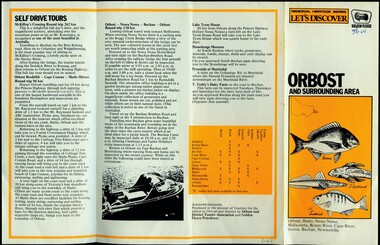
pamphlet, Orbost and Surrounding Area, 1980-1989
Produced in the interest of tourism for the visitor to Orbost and district by Orbost and District Tourist Association in conjunction with Golden Fleece Petroleum.This item is a useful reference tool.A four fold white and yellow pamphlet with black print. On the front is the title -"Orbost and Surrounding Area". There are labelled illustrations of fish above a list of towns. There are description of self-drive tours in the area and a map on the back.pamphlet tourism-orbost -
 Orbost & District Historical Society
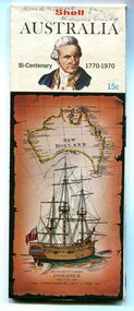
map, Shell Australia, 1970
This Shell road map was made as part of the 200 year celebration of Captain James Cook's voyage on the HM Endeavour and the first sighting of Australia at Point Hicks in 1770. The Bicentenary of James Cook in Australia was commemorated in Australia in 1970. The British explorer Lieutenant (later Captain) James Cook sailed and charted the East Coast of Australia in 1770, and claimed the eastern seaboard of the Continent for the British Crown. This was not considered the official bicentenary of Australia, but rather the mapping of the Eastern coastline. This item reflects the commemoration of a significant event in Australian history.A coloured foldout touring map of Australia with a picture of James Cook and the ship, Endeavour, on the front.map-australia bicentennial-cook-1970 -
 Orbost & District Historical Society
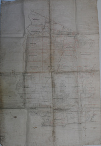
map, early 20th century
This is a useful research tool.A large cloth map with black and red print. Regions are labelled in black capital letters. There are some hand-written notes.on back - J. Leathamcartography map-tambo-shire -
 Orbost & District Historical Society
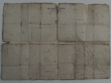
map, Bete Bolong South, March 8 1910
Orbost was at first included in the Bairnsdale Shire from 1882 and was later part of the Tambo Shire. This is a useful research toolA paper shire map of Bete Bolong South, County of Tambo.documents-map-bete-bolong tambo-shire -
 Orbost & District Historical Society
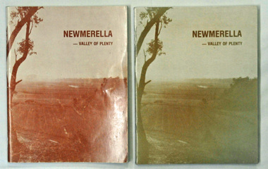
books, Snowy River Mail, Newmerella - Valley of Plenty, March 1978
This book is a useful reference tool on the history of Newmerella.Four copies of a 80 pp soft covered stapled book with a light brown cover with the title, "NEWMERELLA - VALLEY OF PLENTY' in a darker brown print at the top. Below is an illustration of the Snowy River flats. It contains an outline of the history of Newmerella from the beginning of the 19th century until 1978. There are black/white photographs, detailed information and maps.newmerella-history valley-of-plenty -
 Orbost & District Historical Society
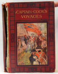
book, Cassell and Company Limited, Captain Cook's Voyages, 1908
James Cook was a British explorer, navigator, cartographer, and captain in the Royal Navy. Cook made detailed maps of Newfoundland prior to making three voyages to the Pacific Ocean, during which he achieved the first recorded European contact with the eastern coastline of Australia and the Hawaiian Islands, and the first recorded circumnavigation of New Zealand.Cook's 12 years sailing around the Pacific Ocean contributed much to European knowledge of the area. This is a useful reference book.A 446pp hard back book titled, "Captain Cook's Voyages" in gold print. It has a black and red cover with a coloured illustration of the landing of James Cook, his crew and the planting of the British red ensign. It has coloured illustrations. Includes Aboriginal encounters with explorers. inside cover - :To Fred from his mother, mas 1910" -
 Ringwood and District Historical Society
Map, Commonwealth Department of Defence, Military Survey map of Ringwood, 1916, Jun-16
Map prepared by Commonwealth Section Imperial General Staff given to Ringwood Historical SocietyMilitary Survey map of Ringwood +Additional Keywords: Hutchins,LL.Hutchins, 16 King's Rd. Marysville 3779. Received by postpak -
 Ringwood and District Historical Society
Map, Department of Mines, Plan of area applied for under the mining leases regulations in the township of Ringwood between Maroondah Highway and Mt. Dandenong Road. Mining District of Castlemaine, County of Mornington, Parish of Ringwood T Area 58(A) 2 (R)15(P) Acres, Roods, Perches. 1934, 20-Feb-34
Map of the township of Ringwood with subdivisions between Maroondah Highway and Mt. Dandenong Road. the area applied for on lease No.8210 by E.G.Browne.Mining District of Castlemaine, County of Mornington, Parish of Ringwood T Area 58(A) 2 (R)15(P) Acres, Roods, Perches.Buff coloured sheet foolscap with black printing showing map of the township of Ringwood between Maroondah Highway and Mt. Dandenong Road. Mining District of Castlemaine, County of Mornington, Parish of Ringwood T Area 58(A) 2 (R)15(P) Acres, Roods, Perches +Additional Keywords: Browne E.G. -
 Ringwood and District Historical Society
Map, Photocopy of Part of a map of Warrandyte -Yarra Valley area year unknown possibly c1930, c1930
Photocopy of Part of a map of Warrandyte -Yarra Valley area year unknown possibly c1930 -
Ringwood and District Historical Society
Badges, Badges and Coins 1939-45: 50 years of Queen Victoria's Reign; ANZAC Pins, King George and Queen Elizabeth; City of Wangaratta; etc, 1939 - 1945
Many issues - ANZAC DayBadges and coins. Refer photograph. +Additional Keywords: Pratt, G / GibbonTop Row L_R:; Victoria - 50 Years of Reign. Diam 3cm.; RDFA/Time Keeper (2 badges); Plastic 7-pointed badge (2 badges): Palestine-Gallipoli, FRANCE, Egypt, Mesopotamia, North Sea, New Guinea. In Centre: Lest We Forget printed across a map of Australia.; Assorted ANZAC pins/badges (5 badges); Middle Row L-R:; Side 1: King George VI & Queen Elizabeth (5 badges); Side 2: City of Wangaratta. Wangaratta Proclaimed a City.; Bottom Row:; Royal Life Saving Society, Established 1891. Centre: Awarded to G. Gibbon 1945.; Awarded to G Pratt v 1945; Victorian Rifle Association (2 badges); Legacy Badges/Pins (2 badges); Map of Australia on metal pin; Badge: Side 1 Centenary of Victoria 1934. On undeveloped scene embossed)/ Side 2 Centenary of Victoria 1935. (On city skyline embossed) Diam 2.6 cm.; Pavilion Fund Bayswater 1947-1948 -
Ringwood and District Historical Society
Book - Inventory, Ringwood Primary School Inventory book (text books,maps, etc). 1961-1969, 1961 - 1969
Ringwood Primary School No 2997. Book containing an inventory of text books, maps and requisites. Education Department Vic Form No. ST 673. The book has alphabetic index tabs; mottled green cover; red cloth spine.Inventory (The Pencraft Faint Indexed Account Book. A Pencraft Production.) -
 Ringwood and District Historical Society
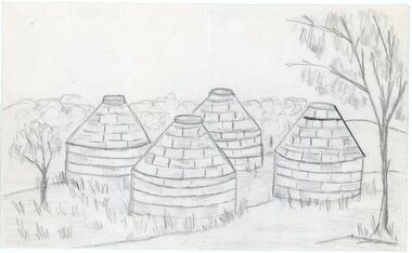
Work on paper - Pencil sketch, Artist unknown, initials D.M, Sketch of pottery kilns at East Ringwood, corner of Velma Grove and Mount Dandenong Road (Oxford Road). Kilns shut down in 1926, c.1926
Sketch of the four pottery kilns at East Ringwood, corner of Velma Grove and Mount Dandenong Road (Oxford Road). The kilns shut down in 1926. Judging by the handwriting, the artist and author appears to be John Rodaughan, East Ringwood historian, whose other works include history on Burnt Bridge Hotel and other parts of East Ringwood. The back of the sketch includes a rough hand-drawn map, that appears to be of the insulator works area, between Mt Dandenong Road and Evon Avenue. The timeline includes generic milestones in blue ink and those associated with Ringwood in red writing.Kilns; D.M. -
Ringwood and District Historical Society
Map, Ringwood -Montrose-Heathmont folded Map with ads for local businesses. C1960s
Front cover missing - ad for power cords and piston rings - originally back cover.White folded map from Ringwood > Montrose E > W and North Ringwood > Heathmont N > S surrounded by ads for local businesses. Not dated. -
Ringwood and District Historical Society
Map, Prepared by Commonwealth Section Imperial General Staff, Topographical map of Ringwood and surrounding areas dated 1-Aug-1935
Topographical map of Ringwood and surrounding areas dated 1-Aug-1935. Two copies.Ringwood Zone -
Ringwood and District Historical Society
Report Book, Education Department Victoria - Inspectors Report Book State School No 2997 Ringwood, May 1948 to April 1955, May 1948 - April 1955
Contains Inspector's Records and various maps and photographs relating to Ringwood School.Education Department Victoria - Inspectors Report Book State School No 2997 Ringwood, May 1948 to April 1955. -
Ringwood and District Historical Society
Report, Radden, W.W.L, History of Anderson's Creek 1856-1865 by W.W.L. Radden January 1965, Jan-65
History of Anderson's Creek 1856-1865 - 7 foolscap pages and map prepared by W.W.L. Radden January 1965 +Additional Keywords: Radden, W.W.L. -
 Ringwood and District Historical Society
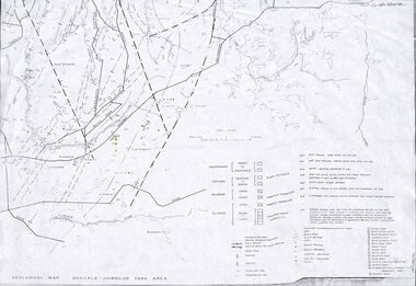
Map - Maps, Geological Map Donvale to Chirnside Park, also Victorian Railways Maps of Hawthorn to Lilydale Line incl Ringwood to East Ringwood - 1881
Faint photocopies of sections of larger maps. Geological map includes location of mine shafts circa 1920.Victory Shaft, North Victory Shaft, South Caledonia Shaft, Caledonia Shaft, North Caledonia Shaft, Black Swan Shaft, Reward Shaft, Consols Shaft, Blocks Shaft, Devonshire Shaft, Crown Shaft, Yarra Tunnel Reef Working, Bright's Shaft, Kingwood Antimony Company Shaft (Boardman's Shaft), Southern Shaft. -
Ringwood and District Historical Society
Map, Government Printer, Melbourne, Ringwood Zone Ordinance Survey Map, 1935
Ordinance survey map glued to cheesecloth, of Ringwood zone - Commonwealth topographical map dated 1.8.35, scale 1:63,360. Information correct up to June 1922. "Ringwood 81" printed on the reverse side.; Envelope and note from donor of item, with return letter of appreciation from Ringwood & District Historical Society dated 20-May-2005. +Additional Keywords: Reid, Don -
Ringwood and District Historical Society
Envelope, Packet: Ringwood - Property Owners 1871; Ratepayers 1890-01; Directory 1905; Maps of Area
1. 1871 property owners; 2. Rate paying electors Legislative Assembly 1890-91; 3. Ringwood Directory 1905; 4. Maps of area -
Ringwood and District Historical Society
Envelope, Nunawading, Ringwood, East Ringwood Land Subdivision Sales, and Grid Map of Melbourne
Land Subdivision Sales - Nunawading; Land Subdivision Sales - East Ringwood; Land Subdivision Sales - Ringwood; Land Subdivision Sales - Grid map of Melbourne -
Ringwood and District Historical Society
Envelope, Packet: 4 maps Ringwood area c.1950
4 maps Ringwood area c.1950 -
Ringwood and District Historical Society
Envelope, Packet: Maps of Ringwood from 1800s to late 1900s
History 1974; Maps of Ringwood -
Ringwood and District Historical Society
Envelope, Packet: History of Ringwood Telecom Site; Maps. August 1985 Booklet. Clippings
History of Ringwood Telecom Site; Maps of area in Ringwood telephone system; Booklet "Welcome to the Phone Age" - August 1985 -
Ringwood and District Historical Society
Envelope, Packet: War Workers (WW2) - Fall of Singapore, Burma Railway Map, Special Editions of Newspapers 1992-993
World War II - Newspapers - 50th anniversary editions; The Australian - Special edition "The Fall of Singapore", "The Day Destiny Struck", Australia at War, Map of Burma Railway -
 Ringwood and District Historical Society
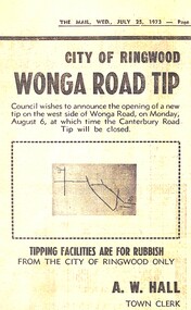
Newspaper - Newspaper Cutting, City of Ringwood, Victoria - opening of Wonga Road Tip by the council - 1973
Newspaper cutting from "The Mail" Wednesday July 25 1973 announcing the opening of Wonga Road Tip by the council. A.W. Hall, Town Clerk. (Accompanying map lacks readable navigation reference points/street names.) -
 Ringwood and District Historical Society
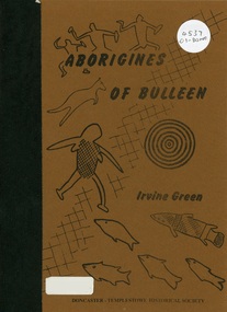
Book, Aborigines of Bulleen, 1989
Soft-cover book with indigenous artwork on brown cover with maps, drawings and photographs outlining the history of local indigenous people who inhabited the area which became the City of Doncaster and Templestowe. -
 Ringwood and District Historical Society
Book, A Tour of the Lilydale Cemetery 1861-1994 Volume One, 1995
Map and history of some of the graves in Lilydale Cemetery, compiled By Sandy Ross, Lilydale and District Historical Society. +Additional Keywords: Mary Hussey / Daniel Cameron / Captain Alexander John Herbert Robertson / Ernest Buckmaster / Jimmy Ah Tak / David Mitchell / Dame Nellie Melba / Jessie Mary Vasey O.B.E., C.B.E. / William Blamire Young -
 Orbost & District Historical Society
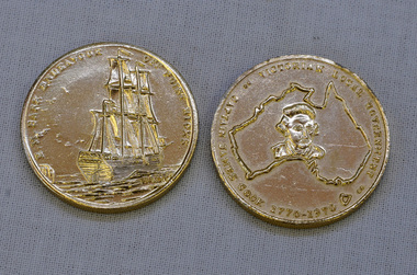
coins, Victorian Local Government, 1970
These coins were made as part of the 200 year celebration of Captain James Cook's voyage on the HM Endeavour and the first sighting of Australia at Point Hicks in 1770. These two coins were presented to Orbost Historical Society by the Orbost Branch of the Bank of New South Wales in 1970.These coins were made as part of the 200 year celebration of Captain James Cook's voyage in 1770 and reflect the importance of that historic event.Two silver coloured coins. On one face is the image of a sailing ship and the words HM BARK ENDEAVOUR OFF POINT HICKS and on the other face is a map of Australia with a head portrait of Capt. Cook in its centre, and the words CAPTAIN JAMES COOK 1770-1970 VICTORIAN LOCAL GOVERNMENT around the edge.as abovecoins celebratory-coins captain-cook australia-discovery