Showing 10747 items
matching plan
-
 Federation University Historical Collection
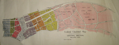
Plan - Plans, Tulloch & King, Federal Electoral Map Subdivision of Ballarat, c1901
It is thought that these are the first federal electorial plans for the Subdivision of Ballarat. The first member of Ballarat was Alfred Deakin.May of the Federal subdivision of Ballarat, with each section depicted in a different colour. The plans include Lake Wendouree, Central Ballarat subdivision; Soldiers Hill subdivision; Ballarat East subdivision, and Central Section Ballarat East, including the Ballarat East Botanic Garden .ballarat, federation, alfred deakin, elections, plan, electoral division, electoral map, polling -
 Glenelg Shire Council Cultural Collection
Plan - Plan - early Portland, n.d
Early plan drawing of PortlandHand-drawn plan on paper, glued on linen backing. Plan shows layout of properties and a lagoon. Hand-tinted in colour. Names of property owners written on lots.plan, map, town, portland -
 City of Moorabbin Historical Society (Operating the Box Cottage Museum)
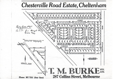
Flyer - Chesterville Road Estate, Cheltenham, 1947
Chesterville Road Estate, consisting of 101 building lots, was sold by private sale in late 1947.Example of the progress of the Municipality of MoorabbinPhotocopy of advertising flyer for sale of real estate sales - plan of building blocks for saleChesterville Road Estate, Cheltenham - plan of subdivisiontennyson street, port street, dennis street, station street, dawn street, hubbard street, chesterville road, cheltenham, real estate, auction -
 Ballarat Tramway Museum
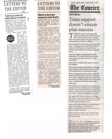
Newspaper, The Courier Ballarat, "Talking buses an alternative to trams", "Where is the tram money to come from", "Tram support doesn't ensure plan success", Aug. 2002
Yields information about the view of letter writers about the proposal for a Ballarat Tourist based tramway in 2002.Set of three newspaper clippings about the return or revival of a tourist tramway in Ballarat. .1 - Photocopy of a newspaper clipping from The Courier - Saturday 24 August 2002 - titled "Talking buses an alternative to trams", written by David Stabb. .2 - Newspaper clipping - from The Courier, Tuesday 27 August 2002, first letter titled "Where is the tram money to come from" written by Michelle Smith. .3 - Newspaper clipping - Editorial - The Courier, Thursday 1 August 2002, titled "Tram support doesn't ensure plan success", also notes the Fast Train to Ballarat. Each item has the date, source and page written in ink.ballarat revival, btm, city tramway -
 Melbourne Tram Museum
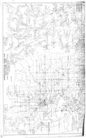
Drawing, Melbourne & Metropolitan Tramways Board (MMTB), "Plan of Tramway System - showing route mileage of electric tramways", Late 1960's
Drawings - dyeline print - titled - "Plan of Tramway System - showing route mileage of electric tramways" - Principal Junctions and intersections shown diagrammatically. Map of system shown at 40 chains to the inch. Drawing No. P6050. Shows crossovers, signal cabins, automatic points, closed cable tram lines in the city area, roads, railways and stations. Originally signed by Perway Engineer - 31-7-1951, last update March 1963. Has a list in the bottom left hand corner of abandoned cable tram lines. See Reg Item 1638 for a 1987 version and 3642 for a 1941 version.trams, tramways, mmtb, trackwork, tramways, junction, map -
 Warrnambool and District Historical Society Inc.
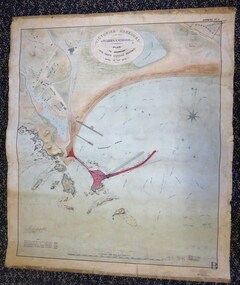
Map - Warrnambool Port 1879, 1879
The port facilities in Warrnambool Bay were in constant use from the first years of Warrnambool’s settlement but there were also difficulties for the shipping trade – a small and unsafe anchorage, the lack of loading facilities and little natural protection from the southerly gales. From the 1870s on there was local agitation for some sort of Breakwater to be built and an Andrew Kerr design was approved by the Warrnambool Council but no funds were made available from the Victorian Government. Throughout the 1870s the building of a Breakwater was a major political issue in the district with preliminary work being funded and started in 1874. In 1879 the Government agreed to a further inspection of the area and an official report. Sir John Coode (1816-1892) was commissioned to make this report. He had come to Australia in 1872 to advise on harbour construction. Coode recommended a 1800 feet long Breakwater and wharf connected to the shore and it was this proposal that the plan described herein and drawn up in 1879 was to accompany. The original plan was eventually modified because of the cost and a Breakwater was completed in 1890 under the direction of the engineer, Arthur Dudley Dobson, with extensions early in the 20th century. This plan is of great interest as it shows in simple graphic form the original plans proposed by Sir John Coode for the Warrnambool Breakwater. It is therefore of great historical importance. The Breakwater was not the maritime success that it was hoped it would be but it is today a significant feature of our foreshore. This is a Plan drawn up in 1879 by Victorian Harbours to accompany Sir John Coode’s Report on the proposed Warrnambool Breakwater. The chart detail is hand-drawn and hand-tinted on canvas with the names of places, geographical and marine features and local points of interest added in print. The edges of the chart are rubbed and the chart is somewhat faded and dirty but the main colours of red, green and brown are still clearly discernible. The title of the plan is printed in an oval inset at the top of the chart. The plan shows two possible Breakwater designs, one from the Borough Surveyor (Andrew Kerr?) and one from Sir John Coode.Victorian Harbours Warrnambool Plan to accompany Sir John Coode’s report Dated 28th Feby 1879 warrnambool breakwater, andrew kerr, sir john coode, arthur dudley dobson, warrnambool, warrnambool harbour, warrnambool history, warrnambool beach -
 Ballarat Tramway Museum
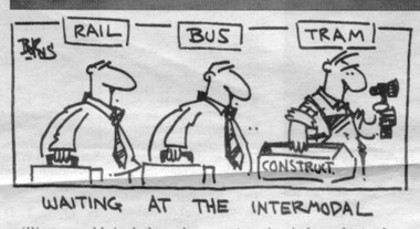
Newspaper, The Courier Ballarat, "$2m upgrade plan for rail station", 24/01/1996 12:00:00 AM
Article from page 5 of The Courier, Wednesday 24/1/1996 written by Ian Haberfield of the Ballarat City Commissioners adopting a proposal last night for a $2m upgrade to the facilities at Ballarat Railway station, including a major transport interchange for buses, taxis and trains. Has a photo of Acting CEO for Ballarat City Doug Forster, Ballarat West MLA Paul Jenkins and Ballarat Station Master, Jim Hevey looking at the plans. Includes a comment by Mr. Forster that the interchange would work well with any tram proposal in the future. Has a cartoon by Courier cartoonist, Burns, about the Intermodal - see image."X" in blue ink in top right hand corner/trams, tramways, ballarat railway station, ballarat city tramway, ballarat revival -
 Ballarat Tramway Museum
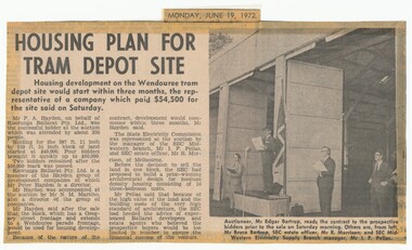
Newspaper, The Courier Ballarat, "Housing plan for tram depot site", 19/06/1972 12:00:00 AM
Newspaper clipping from The Courier, Ballarat, dated Monday, June 19, 1972 titled "Housing plan for tram depot site". Reports on the sale of the former tram depot on Saturday June 17 for $54,500. The purchaser expected to start development of housing on the site within three months. Reports on the sale, purchaser and SEC's views. Features a photo of Edgar Bartrop reading the contract. Others in the photo are Bruce Bartrop, SEC Estate officer, Mr. R. Morrison and SEC Manager Mr. I. F. Pellas. One of a large group of newspaper cuttings from John Bainbridge, 7/4/02.depot, buildings, auctions, bartrop -
Federation University Historical Collection
Book - Report, Ballarat School of Mines Conservation Management Plan, 2016, 2016
The Ballarat School of Mines was the first school of mines in Australasia, and is a predecessor institution of Federation University Australia.CD-ROM of the SMB Campus Conservation Management plan, and a printout of the 390 page Draft report on the Federation University SMB Campus. Contents include: Establishment of the Wesleyan church Reserve Selection of a Site for the Ballarat Gaol and Court House Building the Court of Mines The Gaol Culvert The Ballarat School of Mines Establishment Ballarat iron Workers' Association Ballarat Technical Art School Ballarat School of Mines Museum Acquisition of Lewin's Land The Ballarat School of Mines site in c1970 Master Planning Flecknoe Biulding The Ballarat School of Mines in 1988 Architectects Caselli, Figgus, Molloy and Smith. Public Work Department Architects Ballarat School of Mines Botanical Garden Former Ballarat Junior Technical School Administration Building - Building A W.J. Gribble Building (Ballarat Technical Art School) - Building B Old Chemistry Building Building C Amenities Building, Governor's Quarters, Gaol Gatehouse and Watch Tower and Gaol Walls - Building D Courthouse Theatre (Former Ballarat Supreme Court) - Building F A.W. Steane Building (Former Ballarat Junior Technical School) - Building J Flecknoe Building and E.J. Barker Building (Building N) Old Plumbing Building - Builidng ) Unistyle Haridressing Building (Formerly Ballarat School of Mines Museum and Wesleyan Church) - Building P david rowe, wendy jacobs, ballarat school of mines conservation management plan, ballarat school of mines, buildings, wesleyan church reserve, former ballarat gaol, court of mines, circuit courthouse, gal culvert, ballarat school of mines museum, ballarat technical art school, x-rays, ballarat junior technical school, motor mechanics, wool classing, former governor's quarters, library, flecknoe building, former supreme court, architects, henry richards caselli, figgis, molloy and smith, public work department architects, ballarat school of mines botanic garden, former ballarat junior technical school commemorative gardem, w.j. gribble building, old chemistry building, amenities building, former warden's quarters, courthouse theatre, a.w. steane building, old plumbing building, unistyle hairdressing building, former ballarat post office, post office gallery, former ballarat government offices, cmp, conservation management plan, ballarat school of mines campus, smb campus -
 Federation University Historical Collection
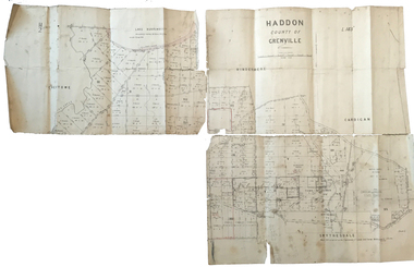
Plan, Haddon County of Grenville, 1887, 1887
Parish Plan of Haddon showing the township of Haddon, Cardigan and Haddon State Forest, Lake Burrumbeet and Nentingbook Pre-emptive Right. Names on the allotments include H. Cuthbert, B. Hepburn, T.W. Lloyd, J. Palmer, E.A. Wynne, William Collard Smith, A. Porteous, P. Russell, J. Mitchell, G. Renniehandwritten 'J. H. Cunningham Applic'haddon, cardigan, haddon state forest, lake burrumbeet, nentingbook pre-emptive right, h. cuthbert, b. hepburn, t.w. lloyd, j. palmer, e.a. wynne, william collard smith, a. porteous, p. russell, j. mitchell, g. rennie, j. noone, department of lands and survey -
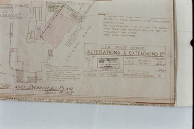 Kew Historical Society Inc
Slide - Architectural Drawing, Kew Public Offices, 1887
A civic campaign for new public offices developed in Kew in the 1880s. After much deliberation, the location chosen was the junction of Bulleen and Cotham Roads. The buildings were designed by George Watson and John Henry Harvey, architects within the Department of Public Works (Victoria). Building was commenced in 1887, and after one year, the buildings were opened. The Post Office was transferred to the new Commonwealth Government in 1901. The Police Station and Court House, sold by the Victorian Government to the City of Boroondara in 2007, are now a community cultural centre and performing arts venue.The buildings were listed on the Victorian Heritage Register Register (HO885) in 1991. They are historically and architecturally significant to the State Of Victoria because Watson and Harvey's designs exhibit diversity in integrating civil offices, they accommodate the apex of road junctions, and they demonstrate a departure from the contemporaneously favoured High Victorian Classical to the Queen Anne style in the design of civic buildings. 35mm colour transparency of an original plan by George Watson and John Henry Harvey, architects of the Department of Public Works (Victoria), in 1887 for New Public Offices at Kew. This plan was copied by the donor from an original held at the Commonwealth Archives in Brighton (Vic). The copy was made to illustrate a report that the donor made on ‘The functional planning design, building materials and construction methods of the Kew Post Office’ as part of course work at RMIT.SITE AND DRAINAGE PLAN / SCALE 16' TO 1"kew court house, kew police station, kew post office, architectural drawings, khs - slides, new public offices -- kew (vic.), architecture — queen anne style -
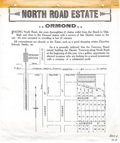 City of Moorabbin Historical Society (Operating the Box Cottage Museum)
Flyer - North Road Estate, Ormond
At the end of World War One, there was a renewed interest in residential land and a number of estates opened up in the Municipality of Moorabbin.Example of the progress of the Municipality of MoorabbinAdvertising flyer for auction of real estate sales - plan of building blocks for saleNorth Road Estate, Ormond - plan of subdivision.36north road, wicklow st, leinster st, ormond, real estate -
![Map, Ballarat and Gordons Lane Plan of Land required [for railway line work]](/media/collectors/5e461d8021ea67224c82f2a1/items/676ff3a62c3783fe00b96a8d/item-media/676ff4a42c3783fe00b96cb6/item-fit-380x285.jpg) Bacchus Marsh & District Historical Society
Bacchus Marsh & District Historical SocietyMap, Ballarat and Gordons Lane Plan of Land required [for railway line work]
The railway line from Melbourne to Bacchus Marsh was completed in February 1887. After this date work continued to extend the line to Ballan. This map indicates a portion of land only a few hundred metres west of the Bacchus Marsh railway station which would have been among the first stages of the line to Ballan to have been constructed. This suggests the date of this map to be in the late 1880s.Single page map showing land required for railway line work near Griffith Street, Bacchus Marsh. Scale 10 chains to 1 inch. Hand-written on the map are the exact distances between Bacchus Marsh and Gordons (Gordon) and between Bacchus Marsh and Melbourne as measured from the corner of Maddingley Road and Station Street. Distances recorded are in miles, chains and links. The land required for the railway works is marked in red ink and runs through an area known as Kennedy's Gully. Part of a set of maps which are pasted into a bound volume containing 76 maps or plans in total. High resolution digital image stored on BMDHS computer network. bacchus marsh victoria history, maddingley victoria history, railway lines -
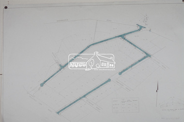
 Eltham District Historical Society Inc
Photograph, Plan 1; Shire of Eltham infrastructure plan for Baldwin Avenue, Lilicur Road and Price Avenue, Montmorency, c.1972, 1972c
Shire of Eltham road construction and realignment works on Baldwin Avenue, Lilicur Road and Price Avenue, Montmorency, c.1972 Note that proposed Hawthorn Grove was not developed35mm colour positive transparency blue Agfacolour Service plastic mountbaldwin avenue, hawthorn grove, infrastructure, lilicur road, price avenue, road construction, sherbourne road -
 Eltham District Historical Society Inc
Photograph, Plan 2; Shire of Eltham infrastructure plan for Baldwin Avenue, Lilicur Road and Price Avenue, Montmorency, c.1972, 1972c
Shire of Eltham road construction and realignment works on Baldwin Avenue, Lilicur Road and Price Avenue, Montmorency, c.1972 Note that proposed Hawthorn Grove was not developed35mm colour positive transparency blue Agfacolour Service plastic mountbaldwin avenue, hawthorn grove, infrastructure, lilicur road, price avenue, road construction, sherbourne road -
 Greensborough Historical Society
Planning Document, Banyule Indigenous Australians Commitment Plan (2012-2016) and 2012-13 Action Plan, 2012-2016
Contains a short history of the Wurundjeri willam, traditional owners of Banyule. Outlines the Banyule Council's Statement of Commitment to Indigenous members of the community.This document contains both historical information and a plan for moving forward in identifying and promoting the culture and heritage of the Wurundjeri willam in Banyule.banyule city council, wurundjeri willam, indigenous heritage in banyule -
University of Melbourne, Burnley Campus Archives
Document - Report, Revised roads plan for Burnley Gardens and Report to accompany Master Plan of Burnley Gardens, 1949-1951
2 documents containing the report by E.M. Gibsontucker, e. m. gibson, administration building construction -
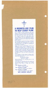 Melbourne Legacy
Pamphlet, Flyer: A business-like plan to help Legacy Plan, 1960s
A copy of a flyer that explains how Legacy uses donations. It mentions the cost of maintaining services for Melbourne Legacy is in excess of $360,000 annually. It mentions a donation of $50 could assist a widow or child. A similar set of proformas are at 00338.A record of forms and items used in Legacy's business practices in the 1960s.White brochure with blue print about donations to Legacy pasted on brown paper from a folio of forms and brochures from the 1960s.proformas, stationery, donations -
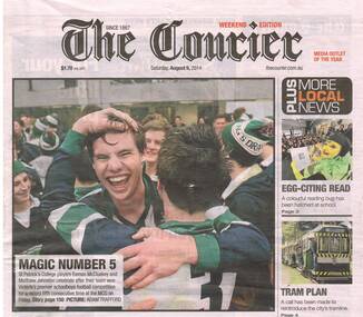 Ballarat Tramway Museum
Newspaper, The Courier Ballarat, "Tram Plan", 9/08/2014 12:00:00 AM
Set of three newspaper cuttings concerning the reinstatement of trams into Ballarat, from The Courier, Saturday August 9, 2014. .1 - Front page of The Courier, with a side photo of 40 on the depot fan, titled "Tram Plan", referring readers to page 4. .2 - Page 4 - "Potential to boost tourism - Bid to bring back city's tramway" - item written by Melissa Cunningham looking at ideas for a city tramway, quotes Peter Hiscock, Ron Edberg, Catherine King MP. Item follows story from Bendigo announcement for a feasibility study. .3 - Page 23 - "Trams for past not future" - Editorial looking at the possible return of trams - on the negative side. Written by Andrew Eales. ballarat, ballarat city tramway, tram reinstatement -
 Melbourne Tram Museum
Pamphlet, Public Transport Victoria (PTV), "Help plan your future tram services", Jun. 2015
Set of two documents - pamphlets to ask passengers about the changes to routes 1, 6, 8 and 55 - 2015. .1 - 3 fold pamphlet, DL size colour on off white paper titled .1 - "Help plan your future tram services" asking feedback via an on-line survey. Shows the possible route changes on a map and basis of the changes. Has contact details on the rear. Two copies held. .2 -DL sheet cut for hanging within a tram, titled "Have your say on proposed changes to these routes - 1, 6, 8, 55, noting that a brochure could be picked up on the tram. Have PTV, Yarra Trams and Vic. Govt. logos.trams, tramways, route 1, route 6, route 8, route 55, route 58, tram routes -
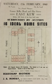 Kew Historical Society Inc
Plan - Subdivision Plan, Subdivision by Auction: 16 Ideal Home Sites, East Kew, 1940, 1940
An advertisement for the sale of a subdivision by Auction: of 16 Ideal Home Sites, East Kew, 1940. This significant sale of land between the Kew Golf Course and Willsmere Park led to the streets having a high degree of architectural uniformity.The subdivision in the second year of the war indicates that land sales for homes and speculation continued from the 1930s into the period of the Second World War. There is no indication on the plan that a war is occurring.Single page subdivision plan advertising the sale by Auction of 16 Ideal Home Sites, in East Kew, on 17 February 1940. Streets named in the plan include: Kilby Road, Belford Road, Elm Grove, Willow Grove. Willsmere Park is indicated but not named. The auction was conducted by Beauchamp Brothers. A number of lots are coloured pink on the plan indicating those lots for sale and/or those already sold.subdivision plans - kew east (vic) -
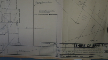 Kiewa Valley Historical Society
Plans - Mt Beauty Swimming Pool & Amenities Building, Mt Beauty Swimming Pool & Amenities Building by Shire of Bright
Mt Beauty's Swimming Pool was built by Alpine Shire and included a Squash Court. October 1986. Previously the community swam in the West and East Kiewa Rivers. The pool enabled all of the community to swim in a safe area and the opportunity to swim long distances.History of swimming for the Kiewa Valley community and its affect on the following - social, education, and tourism6 large pages of black print on yellowed paper. Dated October 1986 and includes plans for the Mt Beauty Swimming Pool and a Squash Court.On back of the 6th plan in red pen "Roger Sorry Delay / Getting Plans Back / Norm Boden"mt beauty, swimming pool, squash court, shire of bright -
University of Melbourne, Burnley Campus Archives
Plan - Teaching Material, Laidlaw & Laidlaw, Patterson Park Metung Draft Conception, January 2013
teaching material, plan, landscape design -
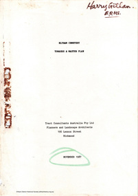 Eltham District Historical Society Inc
Document - Report, Tract Consultants Australia Pty Ltd, Eltham Cemetery: Towards a Master Plan, Nov 1987
BACKGROUND The Eltham Cemetery is of historic significance to the Eltham area. The Trust was established in 1858 and has administered and maintained the cemetery from that date right up to the present. Among the more noteworthy graves is that of Sir William Irvine, a former State Premier and Chief Justice of Victoria. Eltham Cemetery is surrounded on three sides by urban development. Montsalvat Artists Colony adjoins the remaining (eastern) side. A Joint Select Committee of Parliament called the “Mortuary Industry and Cemeteries Administration Committee" (MICA) enquired into the land requirements at the Eltham Cemetery in 1986. The MICA recommendations contained in its 1986 report are included in the Appendices attached to this report. Although the recommendations have not been adopted by the Government it is interesting to note that the MICA report recommended the use of the bulk of the land for cemetery purpose. In June of 1987, the Cemetery Trust was expanded to include additional members from the Eltham Community by the Minister for Health. At the same time, he instructed the Trust to resolve the land requirement issues. As a result of this Ministerial direction, Tract Consultants has been instructed by the Eltham Cemetery Trust to prepare a report addressing the issues raised in the Minister's letter (see Appendix 1) to the Trust. Principally, the study will examine options available for development of the Cemetery. These options will explore possible boundaries, cemetery design, vegetation, the overall environment, landscaping and financial planning for the Cemetery operations. Appendix 2 details the Cemetery Trusts Terms of Reference for the Study. Before commencing the study in detail, additional basic information was sought; viz: a) sub-soil and rock analysis; and b) feature survey by a Licensed Surveyor. The results from both exercises are included as appendices to this report. Section three includes a summary of the findings along with other analytical results. Also: Eltham Cemetery - planning bewteen 1859 to 1860; research by Alan Sheehan April 2015, collated by Harry Gilham, EDHS, April 2016 (2 pages) PROV Guide 5: Cemetery Records (8 pages), printed 7 May 2014Development of Eltham Cemeteryeltham cemetery trust, master plan, mica, montsalvat, mortuary industry and cemeteries administration committee, tract consultants -
 Federation University Historical Collection
Plan, W. Watson, Plan of Caxton Company Smythesdale, 07/02/1886
Framed large ink drawing of a ten head battery, winding and pumping machines, gearhouse and framing. caxton company, smythesdale, w. watson, architectural plan -
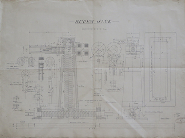 Federation University Historical Collection
Plan - Technical drawing, Hand drawn plan for screw jack, 1916
Ink on paper technical drawing for screw jack technical drawing, screw jack -
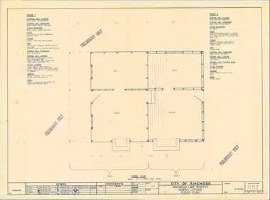 Ringwood and District Historical Society
Plan - Ringwood Lake Reserve Miners Cottage - 1983, Preliminary Building Plans - 3 Sheets. Floor Plan, Elevation, Sectional Views and Details
Sheets 1, 2 & 3 - Construction of replica miners cottage at Ringwood Lake Reserve, opened May, 1983.Preliminary Only -
Moorabbin Air Museum
Plan (item) - C.A.C Plan XP.65
-
Moorabbin Air Museum
Plan (item) - C.A.C Plan XP.68
-
Moorabbin Air Museum
Plan (item) - C.A.C Plan XP.66