Showing 1152 items
matching power street
-
 Glenelg Shire Council Cultural Collection
Functional object - Plate and Whistle, 1950s
Mr Merv Weckert worked the Marion for 30 years and was given the plate upon his departure.Metal plate from Marion crane with air horn attached.Front: Machine number/ 9539/ MARION POWER SHOVEL CO./ MARION OHIO U.S.A. Back: (no inscriptions) -
 Glenelg Shire Council Cultural Collection
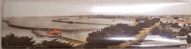
Photograph - Photograph - Portland Panorama, n.d
Plastic coated mounted on metal/fold out stand. View of Harbour taken from "All Saints" steeple. Contains - Baths, Ocean Pier, Long Pier, Fishermans Wharf. Bentinck Street. Unseated - Truck loaded with wool bales. Power poles. Red roofs on Baths, Court House, Richmond Hotel, Bank of Australasia Hand coloured.Front: Panorama of Portland, Victoria (length of Ocean Pier 2880 ft).harbour, photography -
 Glenelg Shire Council Cultural Collection
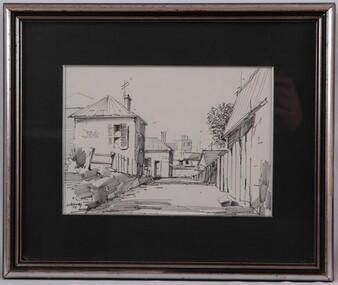
Drawing, Noel Jones, Laneway, 1971
NoneView of a lanway. The laneway begins lower centre of image and recedes into image, halting 1/3 into the image. It is flanked by a high wooden fence on the right and a low wooden pole fence on the left. Behind fence on the right is the top of the wall and the roof of a house. One the left there is a house on a slight hill, rising above the road. There are houses in the background, with power poles and antennae visible above the roof lines. Mounted in black matt. Framed in silver frame with glass.Front: NWJones 71/ (lower left, black felt tip pen) Back: "Laneway" N.W. Jones 31 Linden St Box Hill Sth $25.00 (centre, black felt-tip pen) -
Glenelg Shire Council Cultural Collection
Functional object - Anchor Stock, n.d
Donated by John Edgar? John Francis? Found on Whites Beach? 1990's?Iron anchor stock, ball shaped ends peril at mid point. Curved 120mm off centre, surface incrustations. The stock ensures that the arms rest vertically on the seabed, and thus one fluke will dig itself in, providing maximum holding power. This type, with its two flukes and its stock at right angles, remained the basic anchor for many centuries. -
Glenelg Shire Council Cultural Collection
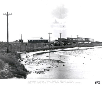
Photograph - Photograph - Portland Harbour Trust - Engineer's office from Cliff St Bridge 22/1/53, 1953
Port of Portland Authority archivesFront: ENGINEER'S OFFICE FROM CLIFF ST. BRIDGE 22/1/53/ MODEL SHED, STORES FENCE & 3 PHASE POWER SUPPLY IN COURSE OF ERECTION (lower centre) Back: P.H.T./ Print No. 3/14 Neg. No 109/ Date taken 22.1.53./ SUBJECT./ % (Ink stamp with blue pen and pencil additions, centre)port of portland archives -
Glenelg Shire Council Cultural Collection
Photograph - Photograph - Portland Harbour Trust - Engineer's office from Cliff St Bridge 23/12/52, 1952
Port of Portland Authority archivesFront: ENGINEER'S OFFICE FROM CLIFF ST. BRIDGE 23/12/52/ MODEL SHED, STORES FENCE & 3 PHASE POWER SUPPLY IN COURSE OF ERECTION (lower centre) Back: P.H.T./ Print No. 3/13 Neg. No 96/ Date taken 23.12.52./ SUBJECT./ % (Ink stamp with blue pen and pencil additions, centre)port of portland archives -
Glenelg Shire Council Cultural Collection
Machine - Sieve Vibrator, n.d
Port of Portland CollectionVibrator for grading samples of sand. 2 Horse Power electric motor, switch, power cord and plug assembly in green steel frame, container and sieve missing.Front: MANUFACTURED BY A.C. CHEERS, COBURG VICTORIAport of portland -
Glenelg Shire Council Cultural Collection
Tool - Underwater Chainsaw, n.d
Underwater chainsaw, pneumatic operation, iron, steel and alloy, painted red, steel blade, no chain, power vane motor and steel hose attachmentsFront: Consolidated Pneumatic Tool Co, London. CP DANARM SAW, Danarm limited, Stroud Glos England M/C No CP4711781 -
Glenelg Shire Council Cultural Collection
Tool - Underwater Saw, n.d
Port of Portland CollectionTubular in shape, forward end handle, fitting for attaching blades at one end and fittings for attaching hose at the other. Pneumatically operated. 3 blades, one fitted to saw, chrome steel and alloy fittings.Front: WRIGHT SAW POWER SAW AND TOOL CORP USAport of portland, tool, saw, harbour -
 Glenelg Shire Council Cultural Collection
Photograph - Photograph - Portland Harbour Trust - Engineer's office from Cliff St Bridge, 1952
Port of Portland Authority archivesFront: ENGINEER'S OFFICE FROM CLIFF ST. BRIDGE 5.11.52/ View showing Model Shed, Storage fence & 3 phase power supply/ in course of erection. (lower centre) Back: P.H.T./ Print No. 3/11 Neg. No 34/ Date taken 5-11-52/ SUBJECT./ % (Ink stamp with blue pen and pencil additions, centre)port of portland archives -
 Glenelg Shire Council Cultural Collection
Photograph - Photograph - Portland Harbour Trust - View of Engineer's Office from Cliff St Bridge, 1952
Port of Portland Authority archivesFront: ENGINEER'S OFFICE FROM CLIFF ST. BRIDGE 4.12.52/MODEL SHED, STORES FENCE & 3 PHASE POWER SUPPLY IN COURSE OF ERECTION (lower centre) Back: P.H.T./ Print No. 3/12 Neg. No 83/ Date taken 4-12-52/ SUBJECT./ % (Ink stamp with blue pen and pencil additions, centre)port of portland archives -
Glenelg Shire Council Cultural Collection
Equipment - Equipment - Diving amplifier, n.d
Port of Portland CollectionFront: Diving amplifier equipment/TYPE 957 SERIAL No 260/ Navy Department Bureau of Ships/ date 11-4-43/ GUIDED RADIO CORPORATION NEW YORK N.Y.port of portland archives -
Glenelg Shire Council Cultural Collection
Functional object - Torch Powered Compass, n.d
Torch powered compass in wooden box. Bottom section cylindrical for holding batteries. Compass housing on top, wider, clear glass top compass visible inside. Small prism attached to side of compass housing. Box square, hinged lid, metal catch, inside shaped to hold torch. Identifying numbers 6663a, b Measures 21.5cm x Diameter top: 10cm x Bottom: 4cm -
Glenelg Shire Council Cultural Collection
Headwear - Top Hat, n.d
Grosgrain ribbon is a type of fabric that has a ridged appearance and is made from silk or synthetic materials. It is regularly used in sewing and crafts, as well as in fashion applications such as millinery and trimming. This type of ribbon is also frequently used to make bows.Denton Hat Mills was built in stages from 1888 until the 1940s. It was Australia's first steam powered hat factory and exported many hats. It remained at hat factory until 1971. Black felt top hat, sides of brim slightly rolled, edged with grosgrain ribbon. Grosgrain ribbon around base of crown. Brown leather headband inside, maker's stamp in leather. 'HENRY' in black texta either side. Set of small pin-holes either side of crown -
Glenelg Shire Council Cultural Collection
Functional object - Diver's intercom, n.d
Port of Portland CollectionSiebe Gorman divers intercom amplifier and central panel. Black steel case chrome bronze fittings to attach cables. Power cord with clips, battery operated. Instrument panel covered with stell lid. Carrying handle on rear.Front: Siebe Gorman Co Ltd/ makers/ London -
Glenelg Shire Council Cultural Collection
Film - Set of 2 DVD'S - Construction of the Port of Portland 1950-1961, Portland Harbour Development, c. 2010
From slides from personal collection of Chief Engineer for the Port, Mr E.P.C. Hughes.Front: 'Power Point Presentation Portland Harbour Development Slides of the construction at Portland Harbour in the 1950's' 'Apple Keynote Presentation Portland Harbour Development Slides of the construction at Portland Harbour in the 1950's'port of portland -
Glenelg Shire Council Cultural Collection
Administrative record - Set of 2 DVD's - Portland Harbour Development 1950-1961, Portland Harbour Development, c. 2010
From slides from personal collection of Chief Engineer for the Port, Mr E.P.C. Hughes.Front: 'Power Point Presentation Portland Harbour Development Slides of the construction at Portland Harbour in the 1950's' 'Apple Keynote Presentation Portland Harbour Development Slides of the construction at Portland Harbour in the 1950's'port of portland -
Glenelg Shire Council Cultural Collection
Photograph - Photograph - Main Breakwater construction, Portland, n.d
Port of Portland Authority Archivesport of portland archives, main breakwater, construction, portland harbour, harbour development -
Glenelg Shire Council Cultural Collection
Photograph - Photograph - Main Breakwater construction, Portland, Apr-54
Port of Portland Authority ArchivesFront: Maion Breakwater from Battery Point 1.4.54 (typed) Purple PHT Stamp. Print No. 4/35 Neg 242 Date taken 1.4.54 - Main Breakwater From Battery Point looking North.port of portland archives, main breakwater, construction, harbour development -
Glenelg Shire Council Cultural Collection
Photograph - Photograph - Lee Breakwater, Portland, n.d
Port of Portland Authority Archivesport of portland archives, ocean pier, portland, harbour, maritime -
Glenelg Shire Council Cultural Collection
Photograph - Photograph - Main Breakwater Construction, n.d
Port of Portland Authority Archivesport of portland archives -
 Eltham District Historical Society Inc
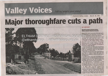
Document - Property Binder, 1045 Main Road, Eltham
Businesses, Eltham, Eltham Physiotherapy & Sports Injuries, Main Roadmain road, eltham, property, shops, businesses, russell yeoman, jim connor, eltham district historical society, plenty river, old eltham road, kangaroo ground, nillumbik council, barry rochford, main road eltham, luck street eltham, aladdin antiques montmorency, main road eltham roundabout, steven white, geoff glynn, michael murray, harold herd, enver camdal, helen bodycomb, rhonda noble, jeph neale, chris marks, john brumby, andrew haermeyer, sherryl garbutt, eltham shopping centre, eltham chamber of commerce and industry, norman williams, pat power, john graves, wattletree road eltham, bolton street eltham -
 Stawell Historical Society Inc
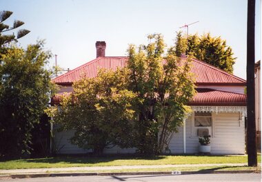
Photograph, 23 Scallan Street
Colour Photgraph: White weatherboard with verandah red iron roof. Treet in front with lawn. Power Pole to Right.On Reverse: 3.2003 23 Scallan Street Stawell Victoria. -
 Ballarat Tramway Museum
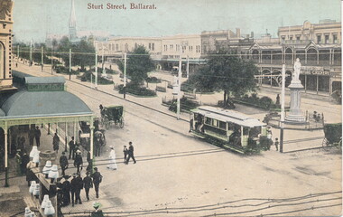
Photograph - Digital image, 1905
... crossing the street and telegraph and power wires. Has... the street and telegraph and power wires. Has the buildings ...Yields information about the appearance of Sturt St and an ESCo tram soon after opening of the Ballarat tramway system and demonstrates postcard printing.Digital image of a postcard of an ESCo tram westbound in Sturt St Ballarat after crossing over Armstrong St. 1905c as the tram has not been fitted with destination boxes. Has the Snows store on the left hand side of the photograph along with people crossing the street and telegraph and power wires. Has the buildings on the north side of Sturt St in the view. Has the title "Sturt St Ballarat". Sourced by Ron Scholten 31/1/2016.trams, tramways, sturt st, armstrong st, esco, postcards -
 Ballarat Tramway Museum
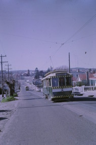
Photograph - Digital image Set of 10, Tony Smith, 5/09/1971 12:00:00 AM
Yields information about Ballarat Tramways and trams prior to the closure of the tramway system.Set of 10 digital images of Ballarat trams prior to closure, scanned from original slides by Tony Smith, 1971 prior to closure of the system. This set of slides, possibly on the last weekend of Mt Pleasant services - closure took place on 5/9/1971. .1 - 13 outbound in Barkly St, Mt Pleasant - with another single trucker and the Ballarat Fire Station in the background. .2 - Bogie tram and single trucker at Grant St Loop. Has the Mobile service station on the right hand side. Note the family sitting on the steps of a house on the left side watching proceedings. .3 - 14 (Mt Pleasant) and 39 ditto. .4 - 27? and 39 crossing at the Morrison St loop. .5 - 14 and another single trucker at Mt Pleasant terminus. Has the corner store in the background with adverts for Robur Tea, Womens Weekly and Coca Cola. .6 - 39 and two single truckers at the Mt Pleasant terminus. .7 - View looking south along Ripon St from Mair St, with power station buildings on the right hand side. Shows the power distribution poles on the street. .8 - Scrubber tram on 0 road with tennis court alongside. .9 - 40 running special in Wendouree Parade, near the Haddon St intersection. .10 - 40 turning from Macarthur St into Drummond St Nth.trams, tramways, mt pleasant, barkly st, grant st, victoria park, sturt st west, ripon st, view st, depot, wendouree parade, drummond st nth, macarthur st, closure, tram 14, tram 39, tram 13, tram 26, tram scrubber, 40 -
 Mission to Seafarers Victoria
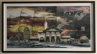
Print - Digital collage, 586, Captured, 2011
"Art is the vehicule for communications far Beyond the confines of a space, while design is the aesthetic cradle in which messages are nurtured and processed." "A 586 rework of the iconic building that has withstood the redevelopment of the Melbourne Docklands and defied the odds. On display a large format print 700mm x 1400mm print. Also a limited run of smaller prints on archival paper also available to support Melbourne's first non-profit charitible organisation that is still self funded, ie. not government funded." During the Open House Melbourne 30-31 July 2011, the artist nicknamed "586" participated in one of the Norla Dome Project Space events sponsored by Bendigo Wealth. Made in Melbourne, 586 is an urban digital experimentalist who blends social narrative with found image creating messages that inspire social consciousness and free thought. Cast in a local foundry back in 1991, 586 was a number, amid hundreds of men working between the ladie and the furnace in a clock on - clock off automated industrious landscape. Legend tells of a time when correspondance to workers was addressed to their number, not their name. Disapproval spread rapidly and a revoit soon followed, eventually the power of the masses won out, but the demoralizing treatment of the worker would go on to shape 586's perception and became the catalyst for a personal protest against social imbalance. This print was on display and smaller prints were also sold to raised funds for the Mission.DigitalLarge digital print of a design that overlays various symbols ( 4 flying angels ), the sails of a sailing ship and contemporary cityscapes and seascapes. centrally features a full photograph of the Mission to seafarers building at 717 Flinders St. Melbourne. Mounted in a large black frame and glazed with perspex .mission to seafarers, flinders street, melbourne, windvane, dome, flying angel, sea, norla dome, bendigo wealth, artist 586, 2011, artwork-paintings, open house, norla dome project space -
 Mission to Seafarers Victoria
Book, Josh Leventhal, Tugs, The World's Hardest Working Boats, 1999
From the Back Cover Whether pulling barges on the Mississippi River, docking ships in Hong Kong Harbor, setting up oil rigs in the Arctic or fighting fires in Vancouver, tugs are without a doubt the world's hardest working boats. Bollard pull is a measure of a tug's potential towing power under certain conditions.non-fictionFrom the Back Cover Whether pulling barges on the Mississippi River, docking ships in Hong Kong Harbor, setting up oil rigs in the Arctic or fighting fires in Vancouver, tugs are without a doubt the world's hardest working boats. Bollard pull is a measure of a tug's potential towing power under certain conditions.tug boat, ships -
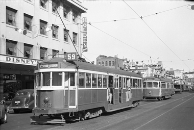 Melbourne Tram Museum
Negative - W2 343 (Essendon Aerodrome Route 59) and SW6 860 (City Route 19) southbound in Elizabeth St, Wal Jack, 10/03/1954
Black and white negative, by Wal Jack, of W2 343 (Essendon Aerodrome Route 59) and SW6 860 (City Route 19) southbound in Elizabeth St, c1955 near to Franklin St Note the Moomba decorations in the overhead. In the background is Disney's (at 416 Elizabeth St a Holden dealer) with flags under the verandah) Rod Atkins advised 7/9/2020: "He was born in Ballarat to Arthur Disney and Isabella Christina Hill. During World War I he served with the Australian Flying Corps and was at Gallipoli. He then became a motor dealer, running his own company. In June 1924 he married Ruby Chapman. From 1935 to 1952 he served on Melbourne City Council. He was elected to the Victorian Legislative Council in 1940 as a United Australia Party member, representing Higginbotham Province; at this time his father still represented Melbourne West for the Labor Party. Disney was a supporter of Ian MacFarlane, and served in his brief ministry in October–November 1945 as Minister of Transport and Mines. He consequently lost Liberal endorsement in 1946 and was defeated. In 1948 he was elected Lord Mayor of Melbourne, serving until 1951; during this period he was closely involved with securing the 1956 Olympic Games for Melbourne. Knighted in 1951, Disney died in 1952 at Auburn.[1] The ones at Swanston street are taken on different days. Yes there is one of those under powered Jaguars parked across the road .... Did you notice the tram signal on the pole? An interesting thing I did not know looking at all three photos is that the flag pole holder on the route number box is on the inside. So when did it move to the outside of the box? On the photo of the RAAF tram, there is one employee wearing a cap but appears to be wearing overalls? I wonder what that is all about? "trams, tramways, sw6 class, w2 class, route 59, route 19, elizabeth st, moomba, tram 343, tram 860 -
 Eltham District Historical Society Inc
Document - Certificate of Title, Landata, Vol. 4930 Fol. 985900, Crown Portion 15 Section 5, Parish of Nillumbik, County of Evelyn, 1925
(Cancelled) Certificate of Title originally issued for Crown Portion 15, Section 5 to Robert David Taylor, of Eltham, County of Evelyn, Farmer, 13 March 1925. It is with this title that the land allotment was subdivided into 48 lots. The title shows the issuance to Robert David Taylor with encumbrance placed upon it by immediate former owner, Hugh Patrick Keogh, a former member for Gippsland and Melbourne Real Estate Agent. Following Taylor's death in 1934 the title passes to his Executors, sons Robert David Taylor of Bible Street, Eltham and William McLelland Vance Taylor of Northcote. The property is then sold to Frank Stokes who develops the Stokes Orchard. Compulsory acquisitions by the Melbourne Metropolitan Board of Works and State Electricity Commission show provisions of easemenst for town water supply and high voltage power transmission lines. Subsequent lots are then sold off with the development of the Stokes Orchard Estate residential development in the mid to late 1970s. A History of the Development of Crown Allotment 15, Section 5, Parish of Nillumbik – Stokes Orchard Crown Allotment 15, Section 5, Parish of Nillumbik (CA15) is a square allotment of 158 acres or approximately a quarter of a square mile. It lies just beyond the eastern end of Pitt Street, south of Nyora Road to the northern end of Eucalyptus Road and extends east from Eucalyptus Road to Reynolds Road. The topography of CA15 is generally steep, sloping up to a hill near the centre of the land, the ridgeline passing through the properties along the southern side of Diosma Road. Eucalyptus Road is a straight north-south road with its northern end at the north west corner of CA15. Until the end of the 1970s this road was an un-named Government Road and was largely not open to traffic. With residential development in the 1970s the road was constructed, and the council allocated the name obviously in recognition of the predominant species of the local bushland. CA15 was purchased from the Crown by George D’Arley Boursiquot, a prominent Melbourne printer, on 28th October 1852. On November 23, 1922, former Member for Gippsland and Melbourne Real Estate Agent, Hubert Patrick Keogh purchased the allotment then sold it March 13, 1925, to local farmer, Robert David Taylor, a former Shire of Eltham Councillor (1911-1920) and Shire President (1919). Taylor had extensive land holdings stretching west towards Bible Street and Main Road. The Taylor home was situated at the top of the hill in Bible Street at present day 82 Bible Street. At the time of Taylor’s purchase in 1925, CA15 was subdivided into 48 lots that could be described as small rural properties or large residential lots. A typical lot size was one hectare or 2.5 acres. The subdivision created two roads, Nyora Road, and Diosma Road, each following an irregular alignment between Eucalyptus and Reynolds Roads. However, the lots were not sold off separately nor were the roads constructed. The land effectively remained as one parcel for many further years. Robert David Taylor died November 30, 1934, and probate was granted to his son of the same name, Robert David Taylor of Bible Street, Salesman and William McLelland Vance Taylor of 73 Emmeline Street, Northcote, Clerk, with the transfer of the land into their names on July 8, 1935. Frank Stokes worked as a qualified accountant at Kennons leather factory in Burnley, while living at 1 Thomas Street, Mitcham. He suffered from migraines and wanted to return to working the land (he had previously worked on farms and orchards since coming to Australia from England in 1926, both in WA and Vic.). He first travelled to the district by train in July 1942 to find land with the intention to establish an orchard. By chance he met Arthur Bird of Bird Orchard (bounded by Pitt Street, Eucalyptus Road, and Wattle Grove) and they got talking over their common interest. Arthur put Frank up for the night and pointed out the land, 158 acres- part of the Taylor Estate- £900, Crown Allotment 15, Section 5, Parish of Nillumbik (CA15) somewhat diagonally opposite Bird Orchard. Stokes applied through the Riverina Agency to purchase the land who in turn applied for permission from Canberra to sell as there was a new government regulation introduced during the Second World War banning land sales except for immediate production. Stokes obtained a loan on his Mitcham house of £600 @ 5% and paid £450 deposit with quarterly payments of £15 spread over 5 years. Stokes was assisted and advised by Arthur Bird who farmed the neighbouring orchard. In early 1943 Stokes took possession and would catch the train out to Eltham on Fridays after work and began building a hut on the corner of Nyora Road and the Government Road (Eucalyptus Road) for shelter and to lock up tools. He established an orchard on the central western part of the land through the centre of which ran a natural waterway (part of the present-day linear park) and was able to pay a neighbour (Hawkins) to help with clearing and fencing 25 acres, and with a horse and single furrowed plough, planted approximately 2,500 fruit trees - cherries, peaches, plums, almonds, pears, apricots and lemons as well as a few apples and oranges; a massive task. Aerial photographs from the 1940s through to the 1990s clearly show the orchard with most of the larger CA15 site remaining as natural bushland. A huge problem was hares and rabbits eating all the new buds off the tiny trees. As well as laying poison he painted the trees with a mixture of cow manure and lime, often working by moonlight. Procurement of wire and wire netting was difficult because of the war but after much effort he obtained a permit from the Agricultural Department for supplies in March 1944. In February 1945 Stokes applied for a permit to build a “packing shed” as no house building was allowed. It was to be 33 feet x 21 feet and cost £312. It was constructed mostly from second-hand materials, which were hard to obtain, especially iron for roofing. Stokes finished work at Kennons on October 31, 1945, and in March 1946 he sold the family home at Mitcham for £1,230 plus £170 for furniture. On May 15, 1946, title to the CA15 property was issued to Frank Howard Alfred Stokes, Orchardist and Gladys Ethel Stokes, Married Woman, both of Pitt Street, Eltham. The family of five then moved into the very unfinished “packing shed” at Eltham, which was a struggle to weatherproof. Eventually rooms were divided off and lined with hessian bags and whitewashed. Their income was firewood (cut and sold), selling rockery stones and cut Sweet Bursaria. (It was discovered during the 1940s that Sweet Bursaria contained the sunscreen compound Aesculin. The RAAF utilised this compound from Sweet Bursaria during WW2 for pilots and gunners.) The orchard’s first fruit sale was a half-case of Le Vanq peaches in December 1947 for the price of 8 shillings. In 1956 plans for house were drawn and Glen Iris bricks purchased (1956 Olympic Rings variant). The building of the house commenced in 1957 - 12 feet of original packing shed was removed – and was completed in 1959. Water was connected from newly built pressure storage on the property at the end of 1959 and the electricity connection for the first time at 3pm on April 29, 1960. The house remains to present day (somewhat modified) at 1 Nyora Road, home to Nyora Studio Gallery. On occasions, spare remnants of the 1956 bricks have been known to be unearthed in gardens on the estate as they were utilised by Frank Stokes to fill in rabbit holes. On May 26, 1950, a parcel of land was compulsorily acquired by the Melbourne and Metropolitan Board of Works on the hilltop to establish an easement for a high-level service reservoir to augment Eltham’s water supply. The project also included pipe tracks for the necessary water mains. The reservoir has now been superseded by higher level water tanks east of Reynolds Road and its former site is now a public reserve. On November 27, 1964, the State Electricity Commission served notice to compulsorily acquire a further parcel through the eastern part of the land for a major electricity transmission line that augmented supply from the La Trobe Valley to Melbourne. The easement was registered February 11, 1966. The easement was widened July 18, 1969 for a second transmission line to be constructed. In 1971 Melbourne Metropolitan Planning Scheme amendments adopted Nyora Road as the boundary between a residential zone to the north and a rural zone to the south. This determined the future development of the land. In the mid-1970s the Shire of Eltham divided the orchard into numerous rate-able parcel lots, the 48 lots having been established in 1925 and the subsequent rates assessment proved unsustainable for Stokes. He commenced selling lots outside the boundary of the orchard, north of Diosma and South of Nyora. However shortly later the land between Nyora and Diosma Roads and west of the electricity easement was sold and subdivided into residential lots, a housing development by Macquarie Builders and marketed as the Stokes Orchard Estate. New streets were created, and most were named after trees, although one, Stokes Place, commemorates the former owners. The development was undertaken in two stages; Stage 1 (1975) encompassing Scarlet Ash Court, Ironbark Close and Peppermint Grove bounded by Nyora and Eucalyptus roads and Stage 2 (1978) encompassing Stokes Place, Orchard Way, The Crest and The Lookout bound by Nyora and Diosma roads. The developer, Macquarie Builders went bankrupt shortly after the release of Stage 2 leaving many purchasers to fend for themselves and arrange for their own independent builders. There were also difficulties with sewerage for the land immediately south of Diosma Road and so the conventional residential lots were abandoned in favour of larger lots. The development of Orchard Way, The Crest and The Lookout did not proceed as planned and the proposed lots were incorporated into five-acre parcels instead. These included a low-density group housing development by the Graves family and the award winning Choong House (1983) with Gordon Ford developed garden immediately next door situated on the ridge of the hill nestled amongst the original bush, Eucalypt trees and Sweet Bursaria. In 1994, Nillumbik Shire Council applied Significant Environment and Significant Landscape overlays upon the properties on the south side of Diosma Road to ensure protection of this natural bush garden environment. With the arrival of the sewer along Diosma Road in the 1990s, most of these five-acre parcels have since been subdivided multiple times. The Choong house presently sits on a 2.7-acre property, which in 2022 Nillumbik Council nominated for Cultural Significance Heritage protection and is considered potentially significant at State level. The Stokes family were also associated with the Eltham Christian Church. In the 1970s this church had met in temporary premises in Eltham. Lots of the original 1925 subdivision remained south of Nyora Road and a number of these lots were utilized for the Eltham Christian School, which was established by the Eltham Christian Church in 1981. The school operated on this site until 2000. The premises are now used by The Vine Baptist Church. By the mid-1980s the whole of CA15 had been developed for residential and school purposes, except for the sections north of Diosma Road and between the transmission lines and Reynolds Road. Sewerage issues had been resolved for the section north of Diosma Road and in 1987 it was in the process of being subdivided into residential lots. The development coincided with the discovery of colonies of the rare and endangered Eltham Copper Butterfly on the site. This resulted in a community and political campaign to save the butterfly habitat. With the co-operation of the land developer the subdivision was altered to create two bushland reserves in the critical butterfly habitat areas. In the late 1980s the State Government was investigating options for establishing a metropolitan ring road link between Diamond Creek and Ringwood. The chosen route was adjacent to Reynolds Road and so this created a freeze on development of CA15 between Reynolds Road and the electricity easement. The ring road proposal was eventually abandoned, and this part of the land was subdivided into low density residential lots. Diosma Road has been discontinued at the electricity easement and the eastern part incorporated into View Mount Court with access from Reynolds Road. The whole of CA15 has now been developed for residential or associated purposes, ranging from conventional density to quite low density south of Nyora Road. Some remnants of the orchard remain, a few cherry trees on the Graves property and a lone apple tree in Stokes Place. The butterfly reserves comprise significant areas of remnant bushland. Linear reserves through the estate link with central Eltham via the Woodridge linear reserve and with Research along the electricity easement. CA15 as it exists today has a complicated history of rural use, Government acquisition, urban development, and community action. References: • “Stokes Orchard, an incomplete history”; Russell Yeoman with Doug Orford • Correspondence, Beryl Bradbury (nee Stokes) • Aerial Photographs, 1931-1991, Landata (landata.vic.gov.au) • Certificate of Title, Vol. 4930 Fol. 985900 • Plan Number LP 10859 neil webster collection, diosma road, eltham copper butterfly, eucalyptus road, ironbark close, nyora road, peppermint grove, power transmission lines, reynolds road, scarlet ash court, stokes orchard estate, stokes place, woodridge estate, frank stokes, certificate of title -
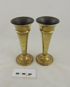 Uniting Church Archives - Synod of Victoria
Functional object - Vase
Marion Rosalie Mapperson, 1920-1946, was the daughter of the Mr and Mrs C Mapperson and was born in a home mission parsonage where she grew up to realise the presence and power of Jesus Christ. She became a fully-accredited local preacher then joined the staff of the Methodist Homes for Children at Cheltenham from there she began her training to be a Methodist Deaconess. Her funeral service was held at the Palmerston Street Church, Carton; it was conducted by the Warden of the Deaconess Institute, the Rev A W Pederick and Rev D W Risstrom. Marion Mapperson was buried at Fawkner Memorial Park. G135.1 and G135.2 brass conical shaped vases with a dedication engraved at the base.G137.1: "Presented by the W.H.M.L. I Memory of Marion Mapperson" G137.2: "Presented by the Deaconesses In Memory of Marion Mapperson"women's home missionary league, marion rosalie mapperson, methodist deaconess, methodist home mission