Showing 171952 items matching "streets "
-
 Tatura Irrigation & Wartime Camps Museum
Photograph, Westpac, Hogan Street, Tatura
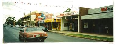
Shows picture of businesses looking east down Hogan street towards the Clock Tower intersection, Hogan Street, Tatura. Colour photograph showing businesses looking east down Hogan Street towards where the Clock Tower is located in Hogan Street, Tatura. Photograph stuck onto piece of white cardboard. hogan street tatura, criterion hotel tatura, westpac tatura, chemmart tatura, maskell real estate tatura, middle cafe tatura -
 Stawell Historical Society Inc
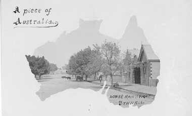
Postcard, Railway Hotel in Lower Main Street Stawell c1900 -- Postcard
Postcard with Australia outline Wooden Railway Hotel Lower Main Street Stawell c1900 with Cattle on roadway near rail crossing. By the "Merle Studio" Main Street Stawell.Postcard with Australia outline Wooden Railway Hotel Lower Main Street Stawell c1900 with Cattle on roadway near rail crossing. By the "Merle Studio" Main Street Stawell.stawell -
 Surrey Hills Historical Society Collection
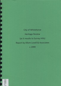
Book, City of Whitehorse Heritage Review (as it relates to Surrey Hills), 1999
A street by street survey of each of the proposed precincts was undertaken. For each precinct, building fabric was defined in terms of intactness, scale, construction type, architect and predominant eras of construction.A street by street survey of each of the proposed precincts was undertaken. For each precinct, building fabric was defined in terms of intactness, scale, construction type, architect and predominant eras of construction.cultural property, protection of historic sites, heritage overlay precincts, heritage review, building citations -
 Kew Historical Society Inc
Slide - Villa, 16 Redmond Street, 1979
One of a group of slides taken by members of the Society of built heritage in Kew in 1979-80. The selection of subject matter reflects the priorities of the period. The colour of some slides has degraded.The slides represent a snapshot in time of built architecture in Kew, much of which has changed in the forty-plus period since they were created.Colour positive transparency (slide) of a single-storey Victorian tuck-pointed polychrome villa (formerly known as 'Roylands', 'Myrambeek') on the corner of Redmond and Fellows Streets, Kew. Research by Lovell Chen established that the house was built in 1892-3 and that owners have included Charles Bennett, Zilpah Bennett, Catherine Bucknall, Frederick Umber, George Darby etc. The 2014 report recommended that the house be included in the Schedule to the Heritage Overlay of the Boroondara Planning Scheme as an individually Significant place."Cnr Redmond and Fellows Streets"historic houses -- kew (vic.), victorian villas -- kew (vic.), 16 redmond street -- kew (vic.), roylands, myrambeek -
 Melton City Libraries
Photograph, Melton Court House, Unknown
The Melton Court House constructed in 1892 and operated for nearly 100 years. It is one of only two early buildings remaining in Melton's main shopping street, and the only nineteenth century building in the street. It has been converted into the visitor centre and cafe.Melton Court House, High Street Meltonlocal architecture -
 Glenelg Shire Council Cultural Collection
Photograph - Photograph - Bentinck and Julia Streets, Portland Victoria, n.d
Black and white photo of Bentinck St, corner of Julia St, looking south. London Hotel on corner, Gordon and Mac's Hotels visible. Cypress pines on right, single horse and dray in street.Back: '12' 'Bentinck Street, Portland (looking south) ' handwritten, black pen -
Stawell Historical Society Inc
Realia, Heslop's Ash Tray, 1970'2
Advertising for electrical Shop on the corner of Main Street and Victoria PlaceClear Glass ash tray marked for Advertising: Compliments of Heslop's BP. Fuels - Lubricants Heslop Electrics149 151 Main Street Stawell Phone 51803advertising smoking -
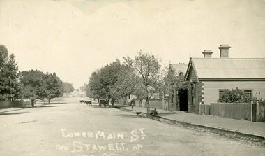 Stawell Historical Society Inc
Photograph, Lower Main Street Stawell. c1905 Looking East towards Railway Line. railway Hotel on Right
Lower Main Street. with Railway Hotel on Right. c1905.Postcard. Lower Main Street. Two Bullocks in the distance, A Carriage under a tree on the right side of Main Street, and a child on the footpath. Railway Hotel on Right.LOwer Main St.stawell transport streetscape -
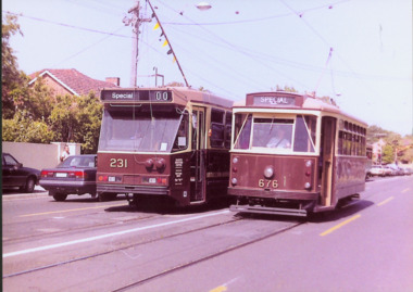 Kew Historical Society Inc
Photograph - Class A 231 & X2 Class 676 in High Street South, 1990
This colour photograph, with 15 others are enlargements gifted to the Society by Mel Lawrence in 2016. They were taken at a commemorative event from the Kew Tram Depot. Laminated colour enlargement of a Class A 231 & X2 Class 676 in High Street South taken at a re-enactment from the Kew Depot in 1990.Annotation reverse: "Kew Depot 1990. Class A 231 & X2 Class 676 in High Street South"kew tram depot, class a trams - melbourne, x2 class trams - melbourne -
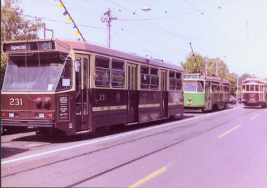 Kew Historical Society Inc
Photograph - A Class 231, Y1 Class B11 & W2 Class 380 in High Street South, 1990
This colour photograph, with 15 others are enlargements gifted to the Society by Mel Lawrence in 2016. They were taken at a commemorative event from the Kew Tram Depot. Laminated colour enlargement of trams in High Street South during a re-enactment from the Kew Depot in 1990.Annotation reverse: "Kew Depot 1990. A Class 231, Y1 Class, B11 & W2 Class 380 in High Street South"kew tram depot, a class trams, trams -- melbourne, y1 class trams, w2 class trams -
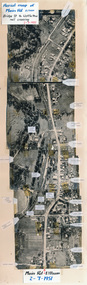 Eltham District Historical Society Inc
Photograph, Aerial map of Main Road, Eltham from Bridge Street to Wattletree Road, 2 July 1951, 1951
... streets ...Constructed from five aerial images stitched together and adhered to a coreflute board (approx 100 x 30 cm) with inscriptions of street names and places written and/or stuck onto surface.eltham, main road, aerial photographs, streets, buildings, houses -
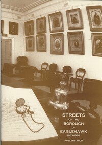 Bendigo Historical Society Inc.
Book - STREETS OF THE BOROUGH OF EAGLEHAWK 1863-1993, c1994
... streets ...Streets of the Borough of Eaglehawk 1863-1993. Soft cover. Publisher: Bendigo Modern Press, Bendigo. ISBN: 0 646 17049 X. 50 pages. Illustrations: photographs, illustrations & map.Noelene Wildbook, eaglehawk, streets, eaglehawk history, street of eaglehawk, pioneers eaglehawk -
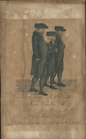 Uniting Church Archives - Synod of Victoria
Printed etching, Undated c.1790
James Hamilton (1740-1827) joined the fledgling Methodist society and became a local preacher. He helped John Wesley to organise Methodism in Scotland. He became an influential member at Wesley's Chapel in City Road London. John Wesley 1703-1791 was the founder of Methodism.Printed etching mounted on timber. Depicts 3 men in profile view as they walk down the street.1. James Hamilton M.D. 2. Revd. John Wesley M.A. 3. Revd. Joseph Cole Drawn as they were seen walking in the Streetjames hamilton, rev john wesley, rev joseph cole, methodist -
Port Melbourne Historical & Preservation Society
Photograph - 127 Nott Street, c 1975
127 Nott Street before alteration. Colour photograph of 127 Nott Street, Port Melbournebuilt environment - domestic, nott street -
 Ringwood and District Historical Society
Document - Research Notes, Richard Carter, Land Subdivisions in Ringwood 1890-1950
Handwritten table listing main local pre-1950s subdivisions in the Ringwood area, with estate names, streets, number of allotments for sale, and where known, vendor agent, LP (Lodged Plan) title registration number, and auction/sale date, some with sale price.Pg1 RINGWOOD STATION ESTATE LP3070 (Year?) Station Street, William Street (now Kendall Street), Wantirna Road, Station Street Pg1 RINGWOOD TOWNSHIP ESTATE LP5577 (1913) Station Road (now Warrandyte Road), Pratt Street (part now Aird Street), Whitehorse Road Pg2 RINGWOOD ORCHARD ESTATE LP4315 (1914) Brysons Road, Hillcrest Road, Anzac Avenue, Sulva Road Pg3 RINGWOOD RAILWAY ESTATE LP7522 (1918) Whitehorse Road (now Mount Dandenong Road), Dublin Road, Freeman Street, Patterson Street, Bona Street Pg4 THE RINGWOOD ESTATE LP7578 (1919) Warrandyte Road, Hobart Street, Paxton Street, Arnold Street Pg5 GARDEN FARMS ESTATE (LP?) (1919) Canterbury Road, Armstrong Road, Bungalook Road, Orchard Road, Bayswater Road (now Mountain Highway) Pg6 THE RINGWOOD ESTATE (SECOND SUB-DIVISION) LP7604 (1919) Warrandyte Road, Tamar Street, Derwent Street, Mersey Street Pg7 RINGWOOD STATION ESTATE LP7703 (1919) Bedford Road, Williams Grove (now Lena Grove) Pg8 RINGWOOD TOWNSHIP ESTATE LP8198 (1919) Wantirna Road, Ellison Street, Haig Street, Greenwood Avenue Pg9 EASTFIELD ESTATE (LP?) (1920) Eastfield Road, Longview Road, Pleasant Rise, The Mount Pg10 ELECTRIC RAILWAY ESTATE RINGWOOD LP9473 (1922) Campbell Street, Myrtle Avenue, George Street (now Tudor Court), Henry Street (now Myrtle Avenue), Williams Grove (now Lena Grove) Pg11 RINGWOOD PARK ESTATE LP7884 (1922 - two stages) Wonga Road (now Loughnan Road), William Street, Andrew Street, Harrison Street Pg12 HEATHMONT STATION ESTATE LP11009 (Date? - after 1922) Lisgoold Street, Viviani Crescent, Balrour Avenue, Station Street (now part Heathmont Road and part Wainui Street) Pg13 RINGWOOD RAILWAY ESTATE LP10507 (1923) Whitehorse Road, Sherbrooke Avenue, Burwood Avenue, Bonview Avenue, Heatherbrae Avenue, Grant Crescent Pg14 GARDEN HOMES ESTATE (LP?) (1923) Mullum Road, The Centreway, Wattle Crescent (now Wattle Avenue) Reserve Crescent (now Reserve Road) Pg15 DUBLIN ROAD ESTATE LP11993 (1923) Alexandra Road, Vonadawn Avenue, Green Street, Wood Street, Howard Avenue, Bedford Road, Dublin Road Pg16 CARLINGA ESTATE RINGWOOD LP9620 (1923) Bourke Street, Bond Street, Ringwood Street Pg17 PRATT'S JUNCTION ESTATE (LP?) (1923) Junction Street, Georges Road, Oliver Street, Whitehorse Road Pg18 EAST RINGWOOD ESTATE LP10492 (1923) Bona Street, Patterson Street, Miller Grove, Fairview Avenue, Eastfield Road, Whitehorse Road (now Mount Dandenong Road) Pg19 COLEMAN'S HEATHMONT ESTATE LP9974 (1923) Canterbury Road, Bedford Road, Alvena Crescent, Coleman Street, Leonard Street (now Royal Avenue) Pg20 RINGWOOD HEIGHTS ESTATE LP10506 (1924) Whitehorse Road, Bonview Avenue, Grant Crescent, Hillcrest Avenue, Heatherbrae Avenue, Margaret Street, Mary Street Pg21 EAST RINGWOOD STATION ESTATE LP10551 (1924) Knaith Road, Wenwood Street, Lois Street, Victoria Street, Station Street (now Railway Avenue) Pg22 GRAND VIEW ESTATE LP11019 (1924) Whitehorse Road, Rupert Street, Herbert Street, Leonard Street Pg23 RINGWOOD RAILWAY ESTATE & RINGWOOD HEIGHTS ESTATE - FINAL SECTIONS LP10506 & LP10507 (1924) Whitehorse Road, Sherbrooke Avenue, Burwood Avenue, Bonview Avenue, Heatherbrae Avenue, Margaret Street, Mary Street, Grant Crescent Pg24 RINGWOOD EAST ELECTRIC STATION ESTATE (LP?) (1924) Railway Parade (now Patterrson Street), Federal Road, Howship Avenue (part now French Street), Dublin Road, Rosedale Crescent Pg25 BEDFORD PARK (now Ringwood Secondary College) (LP?) (1924) Bedford Road, Adams Street, Anderson Street, Joyce Street, Graham Road Pg26 CROWN JEWEL ESTATE LP11645 (Private sales after 1924) Mount Dandenong Road, Mirabel Avenue, Valda Avenue, Evon Avenue, Velma Grove Pg27 GRAND CENTRAL ESTATE LP10917 (1925) Heathmont Road, Great Ryrie Street, Douglas Street, Garden Street, Bellevue Avenue Pg28 RINGWOOD (unnamed estate - 1926) Nelson Street, Seymour Street, Whitehorse Road Pg29 EAST RINGWOOD RAILWAY STATION ESTATE (YEAR? - 25 shops 60 villas) Railway Avenue, Dublin Road, Lawrence Grove, Stanley Avenue, Knaith Road Pg30 CHARM VIEW ESTATE (LP?) (year? - after 1926) Canterbury Road, Heathmont Road, Dickasons Road, Bennjett Avenue, Orchid Street Pg31 SUNBEAM ESTATE LP12150 (Circa 1925) Govt Road (now Old Lilydale Road), Sunbeam Avenue, Holland Road, Everard Street (now Everard Road) Pg32 FAIRVIEW ESTATE EAST RINGWOOD LP10853 (Circa 1924) Eastfield Road, Patterson Street, Margaret Street (now Short Street) Pg33 EAST RINGWOOD TOWNSHIP ESTATE LP3025 (Circa 1924 - 35 allotments) Mount Dandenong Road, Grey Street, Eastfield Road Pg34 EAST RINGWOOD TOWNSHIP ESTATE LP3025 (Circa 1924 - 49 allotments) and STATE SCHOOL ESTATE (26 allotments) and EAST RINGWOOD STATION ESTATE (14 shop sites) Mount Dandenong Road, Grety Street, Dunn Street, Eastfield Road, King Street, Holland Road, Dublin Road, Patterson Street, Bona Street Pg35 EAST RINGWOOD CENTRAL ESTATE LP17004 (1948) Knaith Road, Shasta Avenue, Talofa Avenue, Russet Road, Dublin Road Pg36 WARE ESTATE LP43360 (1958) Ware Crescent, Davey Drive, Grey Road (now Grey Street), Mount Dandenong Road Pg37 Lot 57 Kendall Street LP3070 (1939) £75.0.0 Pg37 Lot 14 LP7346 (year?) £225 Pg37 Lot 8 WHITE HORSE ESTATE LP14010 (year?) Maroondah Hwy, Seymour Street £98.9.0 Pg37 Lots 4-14 incl. LP10902 (year?) £300 Pg37 Lots 69&70 LP2216 (1939) Bedford Road, Pitt Street £500 Pg37 Lots 60&70 LP2216 (year?) £460 Pg37 MOUNTAIN VIEW ESTATE LP10902 (1936) Lots 1&2, 19-22 Wantirna Road, Daisy Street £50 Pg38 RAILWAY STATION ESTATE RINGWOOD EAST LP7522 (1925) Lots 16 to 19 £250 Pg38 RINGWOOD PARK ESTATE (LP?) (1924) Lot 112 Munro Street £230 Pg38 RINGWOOD TOWNSHIP ESTATE (LP?) (1925) Lot 57 Wantirna Road £850 Pg38 ELECTRIC RAILWAY ESTATE LP9473 (1925) Lot 98 & 99 £180 (30/- foot) Pg38 ELECTRIC RAILWAY ESTATE LP9473 (year?) Lot 100 £233.12.6 incl improvements (£2.12.6 foot) Pg38 Lot 22&23 Bedford Road Heathmont (LP & year?) £675 incl improvements Pg39 Lot 9 Mullum Mullum Road LP8221 (1923) £150 Pg39 Lot 27 Haig Street LP8198 (1925) £825 Pg39 Lot 56 Haig Street cnr Wantirna Road LP8198 (1923) £171 Pg39 Lots 3 & 4 Loughnan Road LP9626 (192?) £147 Pg39 Lots 98 & 99 Myrtle Avenue LP9473 (1925) £180 Pg39 Lots 80 & 81 Myrtle Avenue LP9473 (1929) £150 Pg39 Lot 30 Sherbrooke Avenue LP10507 (1926) £700 incl improvements Pg40 Lot 10 (year?) LP7703 £750 Pg40 Lot 36 (year?) LP7522 £25 Pg40 Lot 38 Pitt Street LP2216 (year?) £350 Pg40 Lot 7 Dublin Road cnr Green Street LP11993 (year?) £300 -
![[Section] Drawing room ceiling , 'Villa Alba', Walmer Street (Kew)](/media/collectors/550653872162f11fb04854aa/items/658d13590f23e8f1e738caea/item-media/658d13c20f23e8f1e738ce30/item-fit-380x285.jpg) Kew Historical Society Inc
Kew Historical Society IncPhotograph - Drawing room ceiling , 'Villa Alba', Walmer Street (Kew), c. 1965
"Villa Alba is of significance for the outstanding late Victorian painted decoration throughout its interior. The consistently high standard of design in the decoration, and high, and at times, superb quality of its execution, the variety of illustrative techniques, the variety of illusionist effects and the hierarchy of treatments between the rooms of the house all contribute to the significance. The decorative scheme is also of significance as a fine example of the work of the leading Melbourne decorators, the Paterson Brothers. It is one of their first interiors to depart totally from the use of pre-prepared wallpapers of repetitive designs and it is a rare and comprehensive extant example of their domestic work. The decorative schemes in the ground floor hall, the dining room, the drawing, the vestibule, the stair hall, the upper hall, bedroom 1 and the boudoir are also individually of significance as outstanding examples of Victorian decoration.." (Victorian Heritage Database, 2023)This work forms part of the collection assembled by the historian Dorothy Rogers (1905-1973), donated to the Kew Historical Society by her son in 2015. The manuscripts, photographs, maps, and documents were sourced by her from both family and local collections or produced as references for her print publications. Many were directly used by Rogers in writing ‘Lovely Old Homes of Kew’ (1961) and 'A History of Kew' (1973), or the numerous articles on local history that she produced for suburban newspapers. Most of the photographs in the collection include detailed annotations in her hand. The Rogers Collection provides a comprehensive insight into the working habits of a historian from the 1960s to the 1970s. Original print monochrome photograph of a section of the drawing room ceiling in 'Villa Alba', Walmer Street (Kew)Annotation on reverse: "Villa Alba ceilings. [Stamp - The Royal Women's Hospital, 212 Cardigan Street, Carlton. With Compliments of Public Relations Office]"dorothy rogers, villa alba museum, paterson bros, interior decoration -- 1880s -
 The Beechworth Burke Museum
Photograph
This item has two photographs split horizontally. The top photograph was taken of Camp Street, Beechworth, looking south and the bottom image was taken of Ford Street, Beechworth, looking east.Black and white photograph printed on matte photographic paper. Obverse: Camp Street looking South / Ford Street looking East / Reverse: 1997.3095 / AO3192 / PH 77 / post 1906. / GH. Farley listed 1917-1918. / around 1910. See Camp St. Photo of Coronation arch Showing street lamp beechworth, camp street, ford street, burke museum -
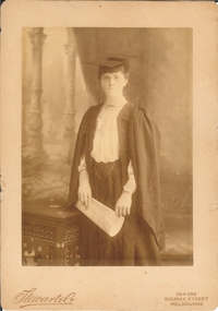 Bendigo Historical Society Inc.
Photograph - FEMALE PORTRAIT: ACADEMIC, 1906
Sepia studio photo. Woman wearing academic regalia, pincenez, ring on 4th. L.H. finger. Figure holds sheet music in both hands. Cane table at figure's right. Studio view in background. Printed in script 'Stewart and Co. Printed in capitals '284 - 286 Bourke Street, Melbourne'at bottom left. Writtyen back"Mr and Mrs Dowsey. With fond love from Auntie May. 19.11.06Stewart and Co., Bourke Street, melbourneperson, individual, female - academic -
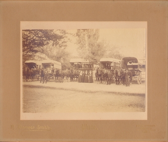 Bendigo Historical Society Inc.
Photograph - C.BUTTON, BENDIGO
Sepia photograph, outside. Large trees in b/ground. 5 covered horses. Drawn wagons with curtains. At centre, 4 females, one holding a child, dressed in white, 3 men standing by horses heads, 2 figures are seated in centre wagon. Wagons at centre + R marked 'C.Button, Bendigo' (C maybe Chas). Inscription: On Front Bottom, 'R.Dermer Smith. Photo. Bull Street/Bendigo'R.Dermer Smith. Bull Street Bendigocottage, miners -
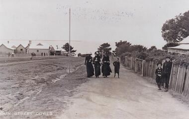
 Phillip Island and District Historical Society Inc.
Photograph, Main Street, Cowes
Building on the right is Robb Brothers StoreCopy of a sepia photo of Main Street,[Thompson Ave] Cowes, showing dirt road with buildings on the right side.Looking south uphill along Thompson Ave. A man on a jinker on road talking to 2 women and another woman standing on right side of road.Main Street [Thompson Ave] Cowes. Robb Bros Storecowes, thompson avenue cowes, photographs, transport - jinker, robb brothers -
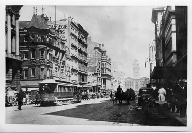 Melbourne Tram Museum
Photograph - Black and White - Elizabeth Street looking south from
Photo of the view looking south to Flinders Street Station, shows a number of motor vehicles and horse-drawn vehicles, along with a motor cycle with a sidecar and one cable tram set hauling a bogie trailer. Note the road surface which appears to be damaged by vehicles. There are a number of puddles showing. Yields information about the view looking south in Elizabeth St. c1920Black and White - Elizabeth Street looking south Little Collins Street, c1920. tramways, trams, cable cars, elizabeth street, traffic, horse drawn vehicles -
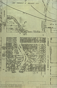 Federation University Historical Collection
Plan, Camp Street Ballarat Parish Plan
Camp Street was the site of the original goldfields camp reserve, and it is from here that soldiers and police troopers left to attack the Eureka Stockade on 03 December 1854.PLan of Camp Street Ballaratcamp street, police reserve, old colonists' association, grenville street, lydiard street north, t. cowan, r. surtees, c.m. watson, w.h. foster, j.b. humffray, j.j. goller, h.r. caselli, henry caselli, market reserve, e.v. gribble, old colonists' association of ballarat -
 Stawell Historical Society Inc
Photograph, Wakeham Street and Seaby Street Stawell formerly the Provincial Hotel 1997
Street Scene - Wakeham Street and Seaby Street (Provincial Hotel) 1997 Provincial Hotel built in 1877 by Mr. Allingham who leased it to Mr. J. Reading. The licensee being held by T.S. Cranston. An advert in 1878 stated 20 good rooms beside out rooms, competent to bed from 40 to 50 persons. Also Billiard and commercial rooms. De licensed in 1916. Weatherboard and Brick building on corner of Seaby & Wakeham Streetstawell, hotel -
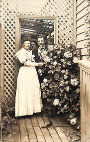 Port Melbourne Historical & Preservation Society
Photograph - Post card of family at 23 Ross Street, Port Melbourne, Kodak Australia, 14 Jan 1908
Post card sent from Priscilla PETERSON ( nee HUME)to her niece Elizabeth PROCTOR (nee HUME) who was living Littleton, Massachusetts, USA in 1908. At the time Pricilla and Frederick were living with their daughter, Lottie at 23 Ross Street, Port Melbourne.Sepia postcard of three members of the Peterson family standing in lattice arch beside a hydrangea bush at 23 Ross Street,, Port Melbourne.On reverse: Mrs H F Proctor, Littleton, Massachuttes (sic) USA. 23 Ross Street, Port Melbourne , Australia, Jan 14 08 Dear Elizabeth Yo said you would like to see us in our home S here we are in our side entrance. Myself, Husband & Lottie. Hope to hear from you soon. Love from all to all. Aunt Priscilla.priscilla peterson, priscilla hume, frederick peterson, lottie peterson, families, elizabeth proctor, ross street -
 Phillip Island and District Historical Society Inc.
Photograph, Cowes Phillip Island, 1920
A stretch of the main Street of Cowes, looking towards Westernport Bay. A narrow strip of the Peninsula in the background. Left side of road depicts a group of buildings and Post Office. A Norfolk Pine in the background. On right side of road on footpath are three women and a child. The women are attired in long black dresses and large smart hats. Along side them is a picket fence, shrubby garden and a house. A small child and male figure popping out the gate.Thompson Avenue, CowesMain Street Coweslocal history, photographs, streetscape, cowes, black & white photograph, mary robb -
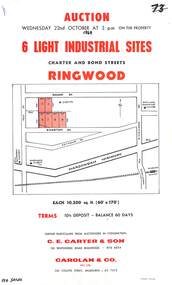 Ringwood and District Historical Society
Flyer, Flyer advertising auction sale of light industrial sites in Ringwood, Victoria - 1969
Single page advertisement for auction sale of 6 light industrial sites in Charter Street and Bond Street in Ringwood on Wednesday 22nd October (1969).Advertisement includes terms of sale and location map. Auctioneers in Conjunction - C.E. Carter & Son, 126 Whitehorse Road Ringwood, (Telephone) 870 6024, and Carolan & Co. Pty. Ltd., 243 Collins Street, Melbourne, (Telephone) 63 7373. -
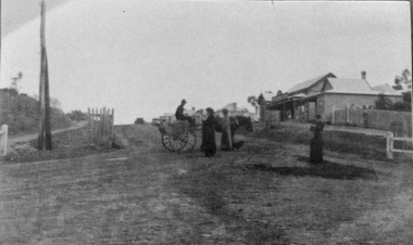
 Ringwood and District Historical Society
Photograph, Outside the Ringwood Market in Maroondah Hwy. 1925
Black and white photograph of street scene showing unmade road with horses and carts at roadsides and wooden buildings to left of photograph. (2 copies)Typed below photograph, "Outside the Ringwood Market in Maroondah Hwy. 1925. Shop in centre (is) at corner of Ringwood Street. ... ". -
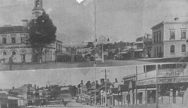
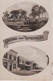 Rutherglen Historical Society
Image, Greetings from Rutherglen, 1910 to 1912
Black and white postcard with two oval photographs with "Greetings from Rutherglen" on a banner between them. The top photograph is of workmen cutting down trees. The bottom one is a view of Main Street looking west.At bottom of top photograph: "Forest Clearing." At bottom of bottom photograph: "Main Street."land clearing, timber felling, main street, bank of australasia, s younkman & co, victoria hotel -
Port Melbourne Historical & Preservation Society
Book, Victorian Readers Third Book, 1940
The Victorian Readers Third Book was the Second Edition printed in 1940 by the Victorian Education Department for use in primary schools. The dark beige cover has the title in black print. The book was used by Glen COSHAM whilst attending Nott Street State School, Port Melbourne in the late 1950's. Cosham Grade 3A Nott Street State Schooleducation - primary schools, nott street state school, glen cosham, victorian education department -
 Linton and District Historical Society Inc
Photograph, Patrick O'Sullivan's Saddlery, Sussex Street, Linton circa 1930-1940
This scanned and labelled image has been copied from an original image lent from the LDHS collection in June 2001; copied by John O'Sullivan, the great grandson of Patrick and Ellen O'Sullivan.Black and white photograph of O'Sullivan's saddlery/harness-maker shop in Sussex Street, Linton. Photograph is believed to have been taken during the 1930s or 1940s (dated by Bennett home next to the saddlery, which was built around 1928)."Patrick O'Sullivan's Saddlery, Sussex Street, Linton c.1930-1940s".patrick o'sullivan, ellen o'sullivan, john o'sullivan, saddlers, sussex street linton