Showing 1522 items
matching streetscape
-
 Ballarat Heritage Services
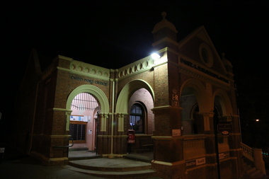
digital photographs, Omeo at Night, 2017
Colour photograph of a building in Omeo at night. 2017, great alpine road, omeo high plains, omeo, high country, streetscape, heritage, night -
 Ballarat Heritage Services
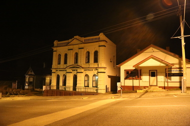
digital photographs, Lisa Gervasoni, Omeo, 2017
2017, great alpine road, omeo high plains, omeo, high country, streetscape, heritage, night -
 Ballarat Heritage Services
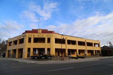
digital photographs, Lisa Gervasoni, Golden Age Hotel, Omeo, 2017, 2017
Colour photograph of the Golden Age Hotel in Omeo.2017, great alpine road, omeo high plains, omeo, high country, streetscape, heritage, golden age hotel -
 Ballarat Heritage Services
digital photographs, Lisa Gervasoni, Omeo, 2017
2017, great alpine road, omeo high plains, omeo, high country, streetscape, heritage, shops -
 Ballarat Heritage Services
Digital photograph, Lisa Gervasoni, Portland, c2015
portland, heritage, building, shops, main street, streetscape, townscape, bayview college -
 City of Ballarat Libraries
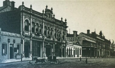
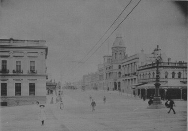
Photograph, Academy of Music, Art Gallery Association & Club Hotel
The view is taken from the cnr of Lydiard & Sturt Street circa 1870-1880 from the Premier Album of Ballarat Views. The Academy of Music is now Her Majesty's Theatre.academy of music, ballarat art gallery, club hotel, streetscape, her majesty's, hotel, entertainment, premier album of ballarat views -
 City of Ballarat Libraries
Photograph, View the Unicorn Hotel of Sturt and Camp Streets
The State Bank and Library buildings and telegraph can be seen. This sketch comes from from the Premier Album of Ballarat Views circa 1870-1880.unicorn hotel, state bank, library, building, streetscape, ballarat, telegraph, premier album of ballarat views -
 City of Ballarat Libraries
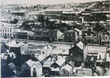
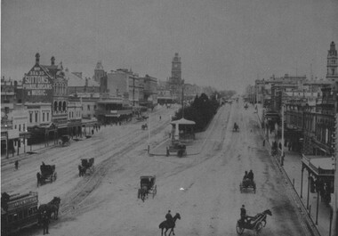
Photograph, View north from Sturt Street circa 1876
This view may have been taken from the Gas Works. Buildings shown include the back of the Mechanics' Institute, Chamber of Commerce and in the distance, Railway sheds.streetscape, oblique view, commerical, building, mechanics institute, chamber of commerce, railway, public -
 City of Ballarat Libraries
Photograph, Golden City Hotel, Ballart circa 1916
The Golden City Hotel still stands on the corner of Sturt and Dawson Streets. Notice the horse-drawn carriage and the motorbike.golden city hotel, building, commerce, hotel, public, streetscape, sturt street, dawson street -
 City of Ballarat Libraries
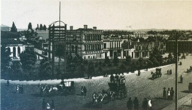
Photograph, Western view along Sturt Street from Grenville Street 1899
Looking west from Grenville Street along Sturt Street. A Horse Drawn Tram can be seen along with the Rotunda.sturt street, grenville street, streetscape, commerical, gardens, trams, horses, ballarat -
 City of Ballarat Libraries
Card Box Photographs, View south along Lydiard Street North from Sturt Street, Ballarat 1899
Taken from Sturt Street, this photo shows Cobb's Corner and Craig's Hotel.lydiard street north, ballarat, sturt street, streetscape, cobb's corner, craig's hotel, streetlamp, buildings -
 City of Ballarat Libraries
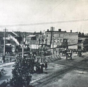
Photograph - Card Box Photographs, Lydiard Street North Railway Station Crossing 1915
Photo of the Lydiard Street North Railway Crossing complete with the railway gates from the Ballarat Homecoming publication. Also seen in the photo is Reid's Coffee Palace and the electric tram line. railway gates, lydiard street north, ballarat, public, reid's coffee palace, railway crossing, streetscape, ballarat homecoming -
 City of Ballarat Libraries
Photograph - Card Box Photographs, Sturt Street, Ballarat circa 1920
Sturt Street view looking south east from Lydiard Street North. You can see both electric trams and horse drawn cabs. The Mechanics' Institute can be seen in the background.sturt street, ballarat, electric tram, horse drawn cab, streetscape, building, commerical, vehicle -
 City of Ballarat Libraries
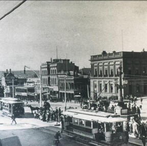
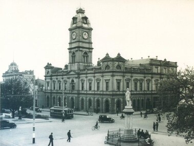
Photograph - Card Box Photographs, Ballarat Town Hall circa 1931
The dome on the National Mutual Building can be seen. ballarat town hall, sturt street, national mutual, building, public, streetscape, vehicle, electric tram -
 City of Ballarat Libraries
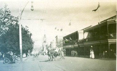
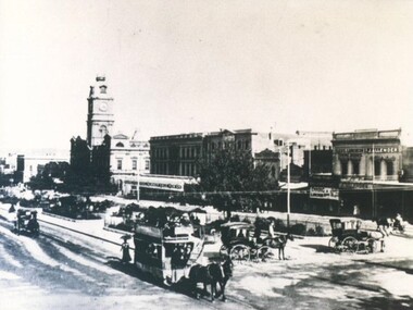
Photograph - Card Box Photographs, View east along Sturt Street from Doveton Street South, Ballarat 1878
The photo shows horse drawn trams and cabs, the Ballarat Town Hall, Theatre Royal and Iles Luncheon Rooms. There are also shades over the garden seats. sturt street, doveton street south, ballarat town hall, theatre royal, iles luncheon rooms, streetscape, commerical, public -
 City of Ballarat Libraries
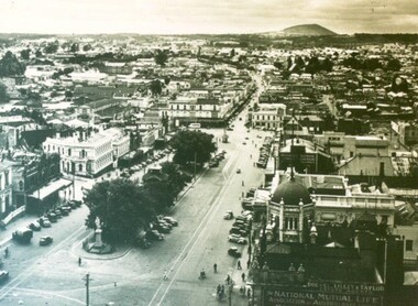
Photograph - Card Box Photographs, View east along Sturt Street, Ballarat circa 1939
The photo was taken from the Town Hall tower. The dome of the National Mutual building is clearly visible.sturt street, town hall, streetscape, national mutual building, commerical, public, vehicle, garden -
 City of Ballarat Libraries
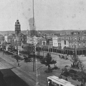
Photograph - Card Box Photographs, South East view over Sturt Street, Ballarat circa 1905. From Star 1855-1905 Jubilee publication
This photo was taken from Doveton Street North looking down Sturt Street to the south east.sturt street, doveton street north, streetscape, gardens, commerical, public, trams, vehicle -
 City of Ballarat Libraries
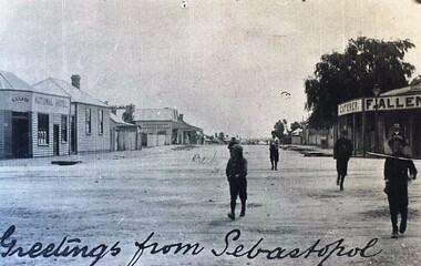
Postcard - Card Box Photographs, Greetings from Sebastopol, 1898
This postcard shows Victoria Street. Pictured is L. (Bub) Jenkins author of 'The Golden Chain'. The two business in the photo are F. Allen Caterer and C.Clark National Hotel.victoria street, sebastopol, streetscape, buildings, commerical, l. (bub) jenkins, f. allen caterer, national hotel -
 City of Ballarat Libraries
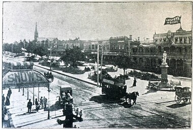
Postcard - Card Box Photographs, Shoppee Square, Ballarat circa 1903
shoppee square, sturt street, lester's hotel, snow's, building, streetscape, vehicle, commerical -
 Bendigo Historical Society Inc.
Photograph - CHARING CROSS Bendigo, c2001
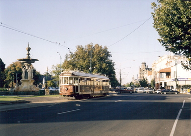
Color photograph. Taken from Charing Cross looking back down Pall Mall. Bendigo Tram, Alexandra Fountain, Queen Victoria behind fountain, Shamrock Hotel down Pall Mall, The Behive sign is also visible on the side of the Behive store. Taken April 2001.Willa, Wenybendigo, charing cross, gordon & wendy willa, alexandra fountain, queen victoria, pall mall, shamrock, streetscape -
 Bendigo Historical Society Inc.
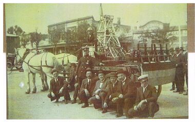
Photograph - KELLY MINE MODEL IN EASTER PROCESSION
Copies (2) of original photo: Print attached to back of photo : Mr. Fred Kelly ( in uniform ) with his complete working model of a mine which took part in the Easter Procession for many years. Mr. Kelly built the mine himself, and included a small steam engine to drive the stampers and make the cage go up and down. The mine was formerly on show upstairs in the Town Hall, and is now at the Deborah mine museum. Written on bottom of photo in black biro : Valda Pinder 54435593 Photo shows 6 seated men, one standing and one driving horse driven cart with mine model on cart. Two white horses drawing cart. Streetscape in background.bendigo, mining, kelly mine model -
 Bendigo Historical Society Inc.
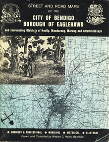
Book - STREET AND ROAD MAPS OF THE CITY OF BENDIGO BOROUGH OF EAGLEHAWK, c1980
Street and Road Maps of the City of Bendigo Borough of Eaglehawk and surrounding Districts of Huntly, Mandurang, Marong and Strathfieldsaye, in color. Drawn and compiled by Wesley C Harry, Bendigo. Publisher: Cambridge Press, Bendigo. ISBN: 9598608.2.2. 68 pages. Photographs, Illustrations & maps. Photos include: Bendigo buildings, scenery mines, streetscapes, parades, pioneer leaders of Bendigo. Many advertisements throughout. List of Justices of the Peace, hospitals, homes for the aged, schools, churches. Page 58: Copy of ''Freedom of the City to the Australian Survey Regiment'' proclamation, 14th June 1970. Maps cover an area of some 169 sq. miles (43,772 hectares). Origin of the name Bendigo. Information on the five Wards of Bendigo, and their councilors.Wesley C Harrybook, bendigo, bendigo & district maps, bendigo and districts map, buildings, streetscapes, historical pictures, advertisements, historical information, commisioners camp, sandhurst -
 Charlton Golden Grains Museum Inc
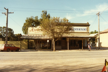
Photograph, Arundell's Shoe Shop, High St Charlton c. 1987
Arundell's Shoe Shop and Dalgety's Agency , centre of High St Charlton, north side c. 1987. Corner of High St and Williams Ave (now John Curtin Drive). Right hand building built by William Williams as a saddlery c. 1910. Arundell's Shoe Shop formerly ANA Boot and Shoe Shop established by John Arundell in 1901. The shop was sold by Vic Arundell in 1980 and closed. Next door was John Watson's Stock & Station Agents which later became Dalgety's. The end shop was the saddlery and then Bullock's grocery 1930's to 1970's. In 1957 became Charlton's first self service store. Became Australian Estates late 1970s. The shops were later demolished to make way for the Traveller's Rest. Part of a streetscape series taken in 1987 for the Charlton Shire.Colour photograph of three single-storey shops with corrugated tin verandahs. Signage on the buildings reads Arundell's SHOE STORE and ESTATES. Partially obscured by tree in front of the buildings. A red station wagon is parked on the LH side of the picture and a boy on a bicycle on the RH side. arundell, dalgety's, williams saddery, john watson stock & station agent, bullock's grocery, australian estates -
 Bendigo Historical Society Inc.
Book - STREET AND ROAD MAPS OF THE CITY OF BENDIGO BOROUGH OF EAGLEHAWK, c1980
Street and Road Maps of the City of Bendigo Borough of Eaglehawk and surrounding Districts of Huntly, Mandurang, Marong and Strathfieldsaye, in color. Drawn and compiled by Wesley C Harry, Bendigo. Publisher: Cambridge Press, Bendigo. ISBN: 9598608.2.2. 68 pages. Photographs, Illustrations & maps. Photos include: Bendigo buildings, scenery mines, streetscapes, parades, pioneer leaders of Bendigo. Many advertisements throughout. List of Justices of the Peace, hospitals, homes for the aged, schools, churches. Page 58: Copy of ''Freedom of the City to the Australian Survey Regiment'' proclamation, 14th June 1970. Maps cover an area of some 169 sq. miles (43,772 hectares). Origin of the name Bendigo. Information on the five Wards of Bendigo, and their councilors. Revised Edition 1986Wesley C Harrybook, bendigo, bendigo & district maps, bendigo and districts map, buildings, streetscapes, historical pictures, advertisements, historical information, commisioners camp, sandhurst -
 Federation University Historical Collection
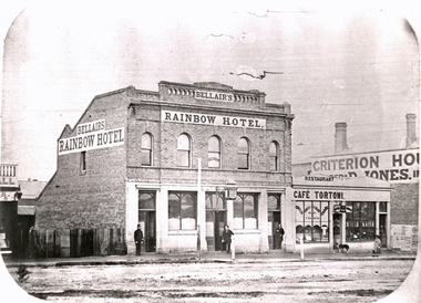
Photograph - Black and White, Solomon and Bardwell, Bellair's Rainbow Hotel, Ballarat
According to Reid and Chishold in 'Ballarat Golden City' "Rainbow Hotel Sturt Street: on the north side near Armstrong Street was built in the 1860s. It was demolished to may way for Lester's Hotel"Double storey brick building with a lamp over the front door. The building is Thomas Bellair's Rainbow Hotel. Cafe Tortoni and Criterion House are also evident in the image. Three men stand outside the Rainbow Hotel, and a woman and dog are shown outside Cafe Tortoni. Gift of the Keith Rash Estatebellair, thomas bellair, rainbow hotel, lestor's hotel, sturt street, armstrong street, streetscape, cafe tortoni, criterion house -
 Bendigo Historical Society Inc.
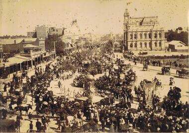
Photograph - PALL MALL LOOKING SOUTH
Photo album, cover has blue cover, maroon spine, spine disconnected from pages. 'Album' on front. Sepia photograph stuck inside front cover of album. Image shows large procession heading north up Pall Mall. On RH side of image: Law Courts, Union Jack flag flying overhead. Conservatory Gardens just visible, palm trees not evident, picket fence along footpath. In centre of image: procession with horse drawn floats; float in front of image has large gold coloured ball above an ornate supporting structure. Written on side of ball ' Gold .tained…' (gold contained?) On LH side of image, 'Harry Davey’ and 'F. Davey' written on shop fronts. All shops along Pall Mall have verandahs. Many people are sitting on balconies and rooftops watching the parade. Appears to be approx. 1890’s?bendigo, streetscape, pall mall, bendigo, sandhurst, procession, gold, post office, pall mall -
 Bendigo Historical Society Inc.
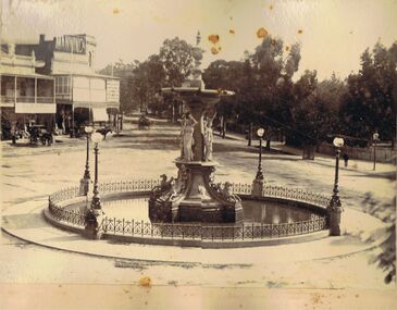
Photograph - ALEXANDRA FOUNTAIN, VIEW POINT, BENDIGO
Sepia image mounted on board: image shows Alexandra Fountain, View Point, Bendigo, looking towards View Street. Fountain surrounded by wrought iron fence. Fountain is not running. Horse drawn cab standing in front of buildings on back LH side. On buildings, Manning & Co., Bisset, importer drapery, clothing, millinery. No tram line in View Street.bendigo, streetscape, alexandra fountain, bendigo, sandhurst, alexandra fountain, view point, manning & co., bisset -
 Bendigo Historical Society Inc.
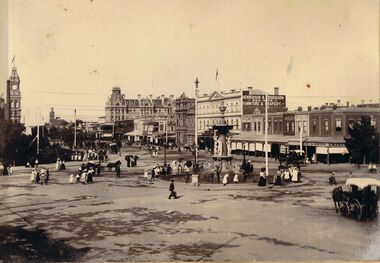
Photograph - ALEXANDRA FOUNTAIN, BENDIGO
Sepia image: image, mounted on board, Alexandra Fountain at Charing Cross, looking north up Pall Mall. On LH side of image, Post Office tower visible, hansom cabs in forefront. Shops along Pall Mall on RH side: Emery & Gibson, Henderson & Goodisson, Beehive, Furniture and Drapery. People in image - women wearing long dresses, hats, men in suits.bendigo, streetscape, alexandra fountain, bendigo, sandhurst, alexandra fountain, hansom cab, post office, henderson & dodisson -
 Bendigo Historical Society Inc.
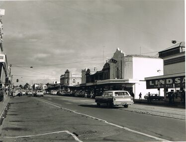
Photograph - MITCHELL STREET, BENDIGO
black and white photo: image shows Mitchell Street, looking south. Lindsays store on corner of Bath Lane, Plaza Theatre on other corner. C 1970's ?place, streetscape, mitchell street, bendigo, bendigo, mitchell street, plaza theatre, lindsays, bath lane -
 Bendigo Historical Society Inc.
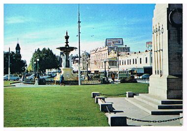
Postcard - ALEXANDRA FOUNTAIN AND WAR MEMORIAL, CHARING CROSS, BENDIGO
Postcard: image shows War Memorial on RH side, Alexandra Fountain in centre, tram in bakcground, cars on street. The Beehive building and Ezywalkin are on RH side of Pall Mall. . Postcard is stuck fast to backing board from album, unable to determine maker.bendigo, streetscape, charing cross, bendigo, pall mall, beehive, ezywalkin, war memorial, alexandra fountain