Showing 2103 items
matching structures
-
 Kew Historical Society Inc
Photograph, Harp of Erin Hotel, c.1880
This work forms part of the collection assembled by the historian Dorothy Rogers, that was donated to the Kew Historical Society by her son John Rogers in 2015. The manuscripts, photographs, maps, and documents were sourced by her from both family and local collections or produced as references for her print publications. Many were directly used by Rogers in writing ‘Lovely Old Homes of Kew’ (1961) and 'A History of Kew' (1973), or the numerous articles on local history that she produced for suburban newspapers. Most of the photographs in the collection include detailed annotations in her hand. The Rogers Collection provides a comprehensive insight into the working habits of a historian in the 1960s and 1970s. Together it forms the largest privately-donated collection within the archives of the Kew Historical Society.Harp of Erin (c.1864-1956). Strategically situated on Bulleen Road (High Street) in East Kew, the ‘Harp of Erin’ was built on the corner of Harp Road and High Street. The present hotel is the third to be built on the site. A second, two storey brick and stucco hotel built c.1864 replaced an earlier wooden structure built in 1854 by Edward Glynn. The ‘Harp’ was a local landmark, used by the Melbourne Hunt Club for their meetings. The Club had their kennels behind the hotel, and at meets, red-coated riders might be seen assembling from all directions. The later building was constructed in 1956."Harp of Erin Hotel. Has been altered several times. First built by Edw. Glynn 1851. Not the first which was built in 1854."harp of erin hotel, dorothy rogers -
 Melbourne Tram Museum
Photograph - Set of 3 Black & White Photograph/s - mounted, 1950s
Series of three Mounted black and white photograph - rail. .1 - close up or high definition of two sections of rail - showing metallurgical structure and failure in one case. Cast numbers 100 and 103 have been written under the respective photographs. .2 - as above for cast Number 54 - showing failure, possibly after testing. .3 - two sections of grooved rail which has been bent around the vertical web without failure. All have a date stamp in top right hand corner "2 Nov 1923" - the three could be another numeral.trams, tramways, rails, testing -
 Orbost & District Historical Society
black and white photographs, November 1976
All of these photographs were taken prior to 25th November, 1876, the official opening and crossing of the current Snowy River Bridge. Gary Downey, an Orbost Apeian, did a "De Groot" and crossed the bridge on horseback prior to the official cars crossing the bridge to signal the opening of the new structure. There was a closing ceremony for the old bridge with a group arriving in a 1927 Chrysler, owned by Apexian, Peter Dreverman. This was watched by groups of school students. Some of the Apex members, including Jim Duggan, Noel Smart and Pat Hall, dressed in formal attire to speak to the audience.This event was organised by the Apex Club of Orbost.The Apex Club of Orbost was a volunteer service club which contributed to the Orbost community. A declining population has led to the demise of many social groups in the area.Ten black / white photographs related to the unofficial opening of the Snowy River Bridge at Orbost. snowy-river-bridge-1976 apex-club-orbost ceremony -
 Marysville & District Historical Society
Photograph (Item) - Colour photograph, Unknown
A colour photograph of the Buxton Hotel in Buxton. The Buxton Hotel was built by William Burchall, probably in the late 1870s. The first owner, who also had land locally, was Frederick Nichols (1833-1904). The Buxton Hotel is located directly opposite the General Store. It was fronted with two huge oak trees and bordered and backed by large pine trees. It was a weatherboard structure with a painted corrugated iron roof. Old split wood shingles were covered by corrugated iron, which overlaid the shingles to make the roof watertight. The wooden shingles date back to the 1850s.A colour photograph of the Buxton Hotel in Buxton.buxton, victoria, australia, buxton hotel, william burchall, frederick nichols, accommodation, carlton draught, photograph -
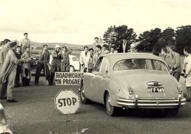 Federation University Historical Collection
Photograph - Photograph - Black and White, Ballarat School of Mines Students at the R.A.A.F. Station, 1961, 1961
The RAAF retained the Ballarat airfield as its Radio School until 1961. The then-Shire of Ballarat negotiated with the Department of Interior to become the civil operator of the airfield and sought the maintenance on site of the hangars and other structures, however a majority of the P Huts were sold by the Commonwealth. (Wikipedia) Sir William Hudson was a New Zealand-born engineer who headed construction of the Snowy Mountains Scheme for hydroelectricity and irrigation in Australia from 1949 to 1967, when he reluctantly retired at 71. The scheme was completed in 1974, under budget and before time. (Wikipedia)A car with the registration plates HFP949 is stopped by a number of male students from the Ballarat School of Mines. It is a reception for Sir William Hudson at the RAAF station (Ballarat airport). Verso: R.A.A.F. Station 1961. See Magazine Reception for Sir William Hudson Visit. ballarat school of mines, raaf, ballarat airport, students, william hudson, sir william hudson, raaf bas, student activity -
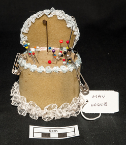 City of Moorabbin Historical Society (Operating the Box Cottage Museum)
Craft work, pin-cushion, c1950
Foam rubber (also known as cellular, sponge, or expanded rubber) refers to rubber that has been manufactured with a foaming agent to create an air-filled matrix structure. Foam rubber was first produced in 1929 by Dunlop researcher chemist Eric Owen using whipped latex. In 1937 isocyanate based materials were first used for the formation of foam rubbers, after World War II styrene-butadiene rubber replaced many natural types of foam. Foam rubbers have been used commercially for a wide range of applications since around the 1940s. A foam rubber ,cylindrical, pin-cushion decorated with lace ribbon c1950 With steel dressmaking pinsmoorabbin, brighton, early settlers, pioneers, cheltenham, dressmaking, craftwork -
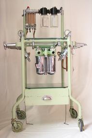 Geoffrey Kaye Museum of Anaesthetic History
Boyle's Machine, British Oxygen Company, circa 1950
This Boyle’s machine was made by the British Oxygen Company (BOC) in the 1950’s. The original Boyle's machine was invented by the British anaesthetist, Henry Boyle in 1917. His machine was a modification of the American Gwathmey apparatus of 1912, and became the best known early continuous flow anaesthetic machine. The Boyle’s machine was first made by Coxeter and Sons, under the direction of Lord George Wellesly, which was later acquired by the British Oxygen Company (BOC). Though a lot of changes have been made to the original design of the Boyle’s machine, the basic structure remains the same today.Green trolley on casters with flowmeter and vaporiser bottles attached to a stainless cross bar. There is a glass shelf at top of the trolley and a second glass shelf at base of trolley, above a pull out drawer. The pull out drawer contains 4 x black rubber masks, 3 x black rubber tubing connectors, 4 x seals, 1 a black corrugated rubber hose with red rebreather bag, red tube and masonite support board.Tin plate attached to upper portion of trolley: THE / BOYLE / apparatus / BY THE BRITISH OXYGEN CO. LTD.henry boyle, anaesthetic machine, gas, oxygen, flowmeter, nitrous oxide, british oxygen company, boc, coxeter and sons -
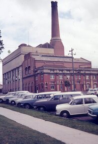 Ballarat Tramway Museum
Photograph - Colour slides - Geelong A Power Station, 1960's and April 1971
1 - Colour slide of the former Geelong A Power Station on the corner of Yarra St and Corio Tce (now Brougham St). First portion on the corner built by the Electric Lighting and Traction Co of Australia. The Geelong tram depot, operated by the Melbourne Electric Supply Co was incorporated within the structure during 1912. Operated by the State Electricity Commission from 1930 until the 1960's. Photo taken prior to the demolition of the chimney during the late 1960's. 2 - Colour slide dated April 1971, taken after the chimney has been demolished. Yields information about the former Geelong A power station prior to its partial demolition and incorporation into a shopping centre. Portions of the original brick buildings have been retained.1 - Green plastic Fuji Film Plastic slide of Photograph of Geelong A Power Station from Yarra St. 2 - Kodachrome cardboard colour slide, date stamped April 1971. No details of Photographer recorded on slide other than the date stamp.geelong, geelong a, power station, mesco, secv, tramways -
 Moorabbin Air Museum
Archive (Item) - Box BDA7 Boeing (Gaf / Asta) Collection
Description: Box BDA 6D - 2 PACKS, NOMAD AIRCRAFT PHOTOS 2 PACKS, GAF FACTORY PHOTOS FILES - - NOMAD LANDING GEAR - NOMAD SEARCHMASTER FAMILIARISATION - NOMAD FLIGHT INSTRUMENT BASIC - NOMAD BASIC STRUCTURES - NOMAD HEAT & VENT, SEARCHMASTER Level of Importance: National. Historical Details: DAP/GAF/ASTA constructed many overseas designs under licence in Australia (Beaufort, Beaufighter, Lincoln, Canberra and F18) however they also designed and constructed a number of significant local designs that were successful in oversea's markets includi -
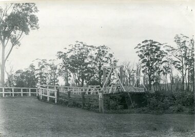 Orbost & District Historical Society
black and white photograph, August 1897
This is a photograph of the bridge from the Orbost side. The first pile bridge over the Snowy River was just completed by Mr Jim Granter when the 1891 flood took out the centre,. There were differences of opinion as to whether the council should pay . The Shire Secretary, Mr John Draffin, persuaded them to honour their obligations. Mr Granter and Mr Clarke finished it as a suspension bridge which was opened by Mrs William Watt. Soon after a mob of cattle stampeded, the weight snapped the cable, letting one side sag. Mr R.P. Cameron repaired it and this bridge remained until 1922. "In 1890 the contract for a bridge was let to Mr James Granter for £1450. This structure with additions and improvements made to it was to cost the ratepayers about £2,500, and its erection was proceeded with in a very satisfactory manner until, just as the greater-part of the work had been completed, the flood of 1891 came down on it, piling up mountains of logs, timber and debris against the piers, which had not been made wide enough apart to allow for. contingencies of this kind. The structure held out bravely until the turn of the flood and then gave way with a crash, about five bays from the centre disappearing in the stream." ( Snowy River Mail August 12 1893) This item is a pictorial record of one of the first bridges across the Snowy River in Orbost.A black / white photograph of the old wooden suspension bridge over the Snowy River. There are two copies 919.1 and 919.2. There are two other photos showing the whole bridge taken from further back.on back - "Orbost Bridge...."snowy-river-bridge-orbost granter-james -
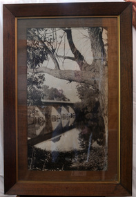 Orbost & District Historical Society
black and white photograph, first half 20th century
This is a bridge across the Snowy River at Orbost. This bridge was built in the 1920s as a road and rail bridge, and was partly washed away by flood waters in 1934. After the end of the first World War the Victorian Railways considered an extension of the railhead across the river at Orbost, and in 1922 a new timber and steel girder structure, a joint Country Roads Board — Victorian Railways venture, was built and completed at a cost of £41,000 (the steel girders came from the Flinders Street viaduct reconstruction). Subsequently it was decided not to take the railway across the river, and the bridge has only been used by road traffic.This is a pictorial record of an early bridge across the Snowy River at Orbost.A very large black / white photograph under glass in a timber frame. It is of a bridge across a river and is framed by trees.bridge snowy-river-bridge road-transport-orbost -
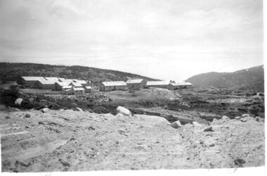 Kiewa Valley Historical Society
11 Black and White photographs of the Rocky Valley area, c1948
In October 1947 construction was commenced on the erection of the workmen's camp at Rocky Valley. Also in 1947 construction of a stream diversion was commenced to allow excavation to commence for the dam wall. In the summer of 1948/49, stripping of the foundation area on both sides of the river was carried out. Weather conditions were not always favourable during the construction, particularly 1955/56 summer, and work would have to cease each year for the winter season due to the severe conditions. The dam is a earth and rock fill structure with a height of about 30.5 metres and crest length 518.16 metres and was completed in March, 1959.These photographs show the type of terrain in the area prior to the construction and filling of Rocky Valley Dam. Also of interest is the type of accommodation provided for those working on the construction and the early cranes available in the 1940/50's. Of historical importance to understand the conditions in the early construction of the Kiewa Hydro Electric SchemeEleven small black and white photographsPhoto No. 1 - on the back, printed in ink"Rocky Valley - New Mess & offices Dec. 1948". In pencil '14 on the back Photo No. 2 - on the back, printed in ink "Rocky Valley Camp. October 1948". Also stamped on the back "998L" Photo No. 3 -on the back, printed in ink "Rocky Valley Hostel October 1948". Also stamped on the back '998L' Photo No. 4 - on the back, printed in ink "Spion Kopje from bedroom window. October 1948". Stamped on the back '998L'. Photo No. 5 - on the back, printed in ink "Rocky Valley Basin Dec. 1948." In pencil on back, 14. Photo No. 6 - on the back, printed in ink "Site of Wall for Rocky Valley Dam Dec. 1948". In pencil on back, 14. Photo No. 7 - On the back, printed in ink "Commencing of Diversion Tunnel Rocky Valley December 1948". In pencil on back, 14. Photo No. 8 - on the back, printed in ink "One of the two electric cranes at Rocky Valley December 1948". In pencil on back, 14. Photo No. 9 - on the back, printed in ink "'Rapier' (H.Y.) electric crane Rocky Valley December 1948". In pencil on back, 14 . Photo No. 10 - on the back, printed in ink " Pretty Valley Pump line construction Mt. Cope in Background Nov 1948. Circular stamp with the words 'print by Wilson White Albury' in the circle. Photo No. 11 - on the back, printed in ink "Stringing cable on Ruined Castle October 1948. Same stamp as No. 10. In pencil '31'. rocky valley; pretty valley; ruined castle; bogong high plains; kiewa hydro electric scheme -
 Kiewa Valley Historical Society
7 small black and white photographs of Pretty Valley, c1948
In 1947 it was proposed to construct a dam on the Pretty Valley branch of the East Kiewa River. This was part of the initial planning in 1937. The Pretty Valley Reservoir was to be part of a pumped-storage scheme with a pumping station located immediately below the main structure. Preparatory work was commenced in 1946 with erection of staff accommodation. Between 1947 and 1950 the main camp was erected, access roads, constructed and banks and benches at the dam site undertaken. Following the financial crisis in 1951, a review of the scheme was carried out and work ceased in June 1951. Construction of the dam was deleted from the programme of works and all buildings removed.A pictorial history of part of the initial planning in 1937 for a dam to be constructed at Pretty Valley as part of the Kiewa Hydro Electric Scheme.7 small black and white photographs of Pretty ValleyAll photos have a circular stamp on the back with 'Print by Willson White Albury' enclosed. Photo 1 - on the back, handwritten in ink 'New 22Kv pump line - Pretty Valley Nov. 1948'. In pencil '18'. Photo 2 - On the back, handwritten in ink 'Pretty Valley - Staff mess on right Nov. 1948'. In pencil '18'. Photo 3 - On the back, handwritten in ink 'Pretty Valley Basin - looking S.E. Nov. 1948'. In pencil '5'. Photo 4 - On the back, handwritten in ink 'New pump 22Kv line, Pretty Valley - looking towards Mt. Mackie. Nov. 1948'. In pencil '5'. Photo 5 - On the back, handwritten in ink 'Pretty Valley. Mt. Cope just out of picture extreme right. Nov. 1948'. In pencil '78'. Photo 6 - on the back, handwritten in ink 'View from Pretty Valley Ruined Castle in Background Nov. 1948'. In pencil '78'. Photo 7 - on the back, handwritten in ink 'Pretty Valley Pump line (Nov. 1948)'. In pencil'78'.construct, dam, pretty valley -
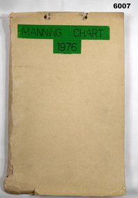 Bendigo Military Museum
Document - Army Survey Regiment Manning Chart 1976, 1976
This document contains detailed photocopies of reports of Army Survey Regiment’s staff manning from December 1975 to August 1976. Each monthly report provided to Directorate of Survey covered the allocation of staff to Regimental Headquarters and its four sub units comprising Headquarters, Air Survey (Topographic), Cartographic and Lithographic Squadrons. Each Squadron’s troop or section structure was represented by a wire diagram with soldiers and/or civilians names assigned to rank based established positions. A detailed table at the end of each report sumarised Army Survey Regiment’s posted strength by employment category and rank.Manilla cardboard folder containing 83 photocopied pages of staff posted to the Army Survey Regiment. Pages are fixed to the folder by a metal fastener. The title of the folder is written in black ink on a green tape background.royal australian survey corps, rasvy, army survey regiment, army svy regt, asr, fortuna -
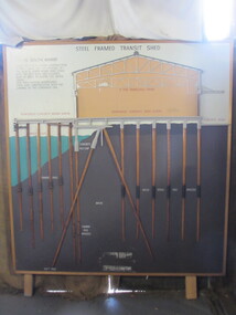 Seaworks Maritime Museum
Diagram
Cross section of wharves and steel framed sheds built along the Yarra river between the 1920s and 1960s. The South Melbourne side of the Yarra River is reclaimed swamp land. Without a solid foundation for the construction of the wharves and transit sheds, extended piles were sunk into the mud to support the wharf and shed structures. An example of this design may be found at 5 South Wharf which was built in the 1930s. The transit sheds gave shelter for cargo while waiting to be loaded onto a ship or to be collected by truck after being unloaded from a ship. The transit shed became surplus to requirements with the introduction of containers.Wooden diagram of a transit shed featuring a shed sitting atop mud with some water. It shows the splices sitting in the mud to support the shed. "Steel Frames Transit Shed/ 15 South Wharf/ Model of Typical wharf construction/ of 1940- made for the opening of/ the "new" 15 South wharf shed (1944),/ Note the deep piles and elevated/ rear of the shed to allow for the truck/ trays./ This shed feature disappeared/ from port construction with the/ coming of the container era/ reinforced wharf apron/ 3 ton travelling crane/ reinforced concrete shed floor/ concrete road/ water level/ concrete pile cap/ cradled piles/ timber pile splices/ mud/ mild steel pile splices/ 110 ft pile" "On loan from Port of Melbourne Authority" -
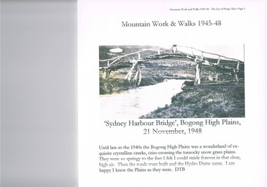 Kiewa Valley Historical Society
Journal - Reference, Mountain Work and Walks 1945-48,The Joy of Being Alive, circa 1950s
This journal detailing the author and friends walks and observations together with black and white photographs of the Kiewa Valley and the Bogong high plains regions during various "walks during the years 1945 to 1948. These walks were undertaken during the various Hydro - electricity generating plants and infra structures were being installed. It relays how the walker and adventurer enjoyed the pristine Alpine regions of Victoria. The wilderness and higher sense of adventure encountered by the author and his "walking party" is now no longer that intense. The isolation of the region was, at that time, still a barrier for the casual adventurer and required a dedication of the "pioneer" mountain walker.The significance of this journal is that both the photographs and accounts of those intrepid adventurers walking throughout the Victorian Alps and the Bogong High Plains details the countryside in one of the remaining years of relative pristine and minimal "tourist" developed regions of rural Victorian. The necessity of greater electrical power supply to the rapidly growing demand from cities and larger towns, post World War II immigration, had resulted in drastic changes to the infrastructure of the Victorian Alpine regions and particularly the Kiewa Valley. The photographs and the written accounts of the "adventurers" in this journal presents the last phases of the " Australian rough outback environment" and also the typical "bush wise" city/town dweller that although lived in towns and cities still had the adventurers heart of their fore fathers.This item has been photocopied by the author of his journal, consisting 27 pages of A4 size paper. A covering letter by the author is at the front of this loose leafed journal. The journal is bound in a yellow plastic cover with spirals. At the back is a 2 page biography of Myrtle Emily (Grigg) Deamer 1922-2006, then a photo of Meg with baby Bryn and son Tony followed by a letter from David BottomleyThe author's correspondence and covering letter has his signature "D Bottomley"alpine country, bush walking, bogong mountain, alpine adventures -
 Marysville & District Historical Society
Photograph (Item) - Black and white photograph, Unknown
A digital copy of a black and white photograph of the Buxton Hotel in Buxton. The Buxton Hotel was built by William Burchall, probably in the late 1870s. The first owner, who also had land locally, was Frederick Nichols (1833-1904). The Buxton Hotel is located directly opposite the General Store. It was fronted with two huge oak trees and bordered and backed by large pine trees. It was a weatherboard structure with a painted corrugated iron roof. Old split wood shingles were covered by corrugated iron, which overlaid the shingles to make the roof watertight. The wooden shingles date back to the 1850s.A digital copy of a black and white photograph of the Buxton Hotel in Buxton.buxton, victoria, australia, buxton hotel, photograph, william burchall, frederick nichols -
 Marysville & District Historical Society
Photograph (Item) - Black and white photograph, Mark James Daniel, 1904
A digital copy of a black and white photograph of Nichol's Buxton Hotel in Buxton. The Nichol's Buxton Hotel was built by William Burchall, probably in the late 1870s. The first owner, who also had land locally, was Frederick Nichols (1833-1904). The Buxton Hotel is located directly opposite the General Store. It was fronted with two huge oak trees and bordered and backed by large pine trees. It was a weatherboard structure with a painted corrugated iron roof. Old split wood shingles were covered by corrugated iron, which overlaid the shingles to make the roof watertight. The wooden shingles date back to the 1850s.A digital copy of a black and white photograph of Nichol's Buxton Hotel in Buxton.buxton, victoria, australia, buxton hotel, nichol's buxton hotel, photograph, william burchall, frederick nichols -
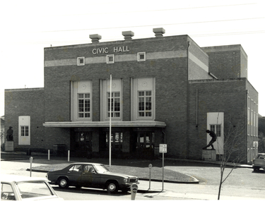 Federation University Historical Collection
Photograph - Photograph - Black and White, Ballarat Civic Hall, c1965
The City of Ballarat unanimously resolved to erect a Civic Hall in 1951. The architects, Gordon Murphy, of Melbourne, and H.L. and L.J. Colburn, of Ballarat, were commissioned in 1952. The Council constructed the foundations and footings for the building under the supervision of the former City engineer, Mr L.H. Finch, in 1953. These footings are of massed concrete. The design for the building took advantage of the cross fall of the land, providing for the Small Hall to be entered from the Doveton Street frontage through a foyer under the Main Stage, the structure is steel with brick panels, with accommodation for 1,592 persons in the Main Hall and 440 persons in the Lower Hall. Black and white photograph of a brick building known as Ballarat Civic Hall. It is located on the corner of Mair Street and Doveton Street North. The Shakespeare statue out the front of the building was unveiled on 17 November 1960. ballarat civic hall, civic hall, colburn, finch -
 Robin Boyd Foundation
Document - Manuscript, Robin Boyd, Under Tension, 1963
Boyd argues that modern architecture has triggered a necessity for greater harmony between architects and engineers. Boyd describes the architectural qualities of tension structures through an analysis of several case studies including projects by Frei Otto and Boyd's own house at Walsh St. Being a relatively new concept, Boyd criticises the neglect towards smaller buildings in this structural system, and also highlights some of its shortcomings. A 2-page letter from 'Arthur' (surname unknown) at the University of Melbourne's Department of Civil Engineering provides feedback to Boyd on his analyses of the chosen case studies.Original manuscript of article published in The Architectural Review Vol.134, No.801, November 1963, pp. 324 - 334. This draft was returned with covering letter from: ‘Arthur’ (AJF) Melbourne Uni. Dept Civil Engineering. Typewritten (c copy), foolscap, 14 (+2 quarto letter) pagesMinor handwritten editsengineering, tensile structure, master-designer, bernard lafaille, zagreb french pavilion, matthew nowicki, livestock pavilion, frei otto, paul rudolph, florida house, bill irwin, kevin borland, peter mcintyre, john and phyllis murphy, yuncken freeman, sidney myer music bowl, eero saarinen, yale hockey rink, edward d. stone, brussels u.s. fair pavilion, boston arts centre, walsh street, robin boyd, manuscript -
 Kew Historical Society Inc
Photograph - Cosy Five Roomed Rough Cast Bungalow, Kew, J E Barnes, c.1920
Subdivision plans are historically important documents used as evidence of the growth of suburbs in Australia. They frequently provide information about when the land was sold on which a built structure was subsequently constructed as well as evidence relating to surveyors and real estate and financial agents. The numerous subdivision plans in the Kew Historical Society's collection represent working documents, ranging from the initial sketches made in planning a subdivision to printed plans on which auctioneers or agents listed the prices for which individual lots were sold. In a number of cases, the reverse of a subdivision plan in the collection includes a photograph of a house that was also for sale by the agent. These photographs provide significant heritage information relating house design and decoration, fencing and household gardens. The photograph is also aesthetically significant as it was taken by J. E. Barnes, a nationally significant photographer. He was the most important photographer to have worked in Kew. He was active as a photographer in the district from c.1906 until his death in 1921. Best known as 'the Embarkation Photographer' (see the Australian War Memorial collection), Josiah Earl Barnes was also the official photographer employed by the Borough (and later Town, then City) of Kew. He clearly also completed commercial jobs for local businesses, as is the case in this photograph of a house for a local real estate and financial agent. A modest weatherboard house with rough-cast rendered walls. The gabled entrance incorporates elements of the Japanese aesthetic. The strong lines of the dark timber gable are reinforced by the colour and shape of the pickets in the fence. In contrast to an earlier period, the chimneys appear truncated. The use of extensive double-hung sash windows in the front rooms reflects a new interest in light in houses. The use of separate sunshades over windows in an earlier period is here replaced by an extension of the roofline over the window. The photographer Josiah Barnes died in 1921; so, the photograph of the house must predate this date. The location of the house, which was advertised for sale, has to date not been identified. Illegible inscription. Photographer's information on mount.josiah earl barnes, j e barnes, photography - kew, interwar housing - victoria, 1920s housing - kew -
 Kew Historical Society Inc
Photograph - 2 Young Street, Kew, Paramount Photos, 1920s
Subdivision plans are historically important documents used as evidence of the growth of suburbs in Australia. They frequently provide information about when the land was sold on which a built structure was subsequently constructed as well as evidence relating to surveyors and real estate and financial agents. The numerous subdivision plans in the Kew Historical Society's collection represent working documents, ranging from the initial sketches made in planning a subdivision to printed plans on which auctioneers or agents listed the prices for which individual lots were sold. In a number of cases, the reverse of a subdivision plan in the collection includes a photograph of a house that was also for sale by the agent. These photographs provide significant heritage information relating house design and decoration, fencing and household gardens.A prepossessing, large home constructed in the Arts and Crafts style. Located on the banks of the Yarra at 2 Young Street, Kew overlooking the factories of Richmond, the design of the house takes account of the gradient with the addition of a level below the front entrance. The elegant roof includes a number of projecting gables and dormers. The gables are typically half-timbered and rendered. In addition to the asymmetrically placed portico, there are at least two open verandas, supported by timber pillars and with roofs that reflect the overall pitch of the roof of the housereal estate photographs, 2 young street - kew -
 Kew Historical Society Inc
Photograph - 8 roomed DF Brick Villa, Kew, J E Barnes, c.1920
Subdivision plans are historically important documents used as evidence of the growth of suburbs in Australia. They frequently provide information about when the land was sold on which a built structure was subsequently constructed as well as evidence relating to surveyors and real estate and financial agents. The numerous subdivision plans in the Kew Historical Society's collection represent working documents, ranging from the initial sketches made in planning a subdivision to printed plans on which auctioneers or agents listed the prices for which individual lots were sold. In a number of cases, the reverse of a subdivision plan in the collection includes a photograph of a house that was also for sale by the agent. These photographs provide significant heritage information relating house design and decoration, fencing and household gardens. The photograph is of additional aesthetic significance as it was photographed by J. E. Barnes. Josiah Earl Barnes is a nationally significant photographer. He was also the most important photographer to have worked in Kew. He was active as a photographer in the district from c.1906 until his death in 1921. Best known as 'the Embarkation Photographer' (see the Australian War Memorial collection), J. Earl Barnes was also the official photographer employed by the Borough (and later Town, then City) of Kew. He clearly also completed commercial jobs for local businesses, as is the case in this photograph of a house for a local real estate and financial agent.A photograph, mounted on board of a double fronted Federation-era brick villa in Kew, photographed for a local real estate agent and financier by J. E. Barnes of Kew. On the reverse of the photograph is a subdivision plan for the Normanby Estate, East Kew - 2016.0039.1. As can be seen from the image, there is a large tear on the surface of the photograph.The brown card on which the photograph is mounted includes the following handwritten description, which may aid the identification of the house: "Kew, 3 minutes from tram, 8 roomed DF Brick Villa, tile roof including two attics, sleepout, bathroom, heater, E Light, Entrance Hall, double doors, leadlights, laundry, garden, lawns, land 75 x 170, 1975 pounds". Also photographers inscription on mount, lower left: J. E. Barnes / Photo / Phone 1966 Haw. KEW.j. e. barnes, josiah earl barnes, j. earl banes - photographer, architecture - federation style, houses - kew, real estate photographs -
 Kew Historical Society Inc
Map, Department of Lands & Survey, Map of Melbourne & Suburbs, 1899
The Melbourne & Metropolitan Board of Works was established in 1891 to oversee the introduction of a sewerage and water reticulation system in Melbourne and its suburbs. This complementary map was produced by the Department of Crown Lands & Survey [Victoria] in the same decade showing the distribution of water in Melbourne for use by fire brigades. While by 1910, there were 123,227 connections to Melbourne's water supply system, it is unclear in this 1899 map whether water was supplied to all built structures in the defined areas or only to fire hydrants and stand pipes, as we know that the first connection of a building to the sewerage system in Kew only occurred in 1904.Map accompanying report on fire protection of Melbourne showing those areas supplied with water in colour.water reticulation -- melbourne (vic.), department of lands & survey -- historic maps, fire brigades -- melbourne (vic.), cartography -
 Vision Australia
Badge - Object, Daisy consortium anniversary badge, 2011
The DAISY consortium was established in 1996 to develop an industry standard for the emerging digital book market. It's partners recognised that by incorporating the same features when constructing digital recordings with text, and using an established structure, publications could be usefully exchanged and sent around the world. In 2011 the consortium celebrated it's 15th anniversary and commemoration badges were sent to it's members, which included NILS (the production and library divisions of the Royal Blind Society of NSW, Vision Australia Foundation and RVIB). The badge has a blue swirl above and below the words 'daisy consortium' with '15th anniversary' at the base.Small badge with black writing on white backgrounddaisy consortium 15th anniverary badges, national information library service -
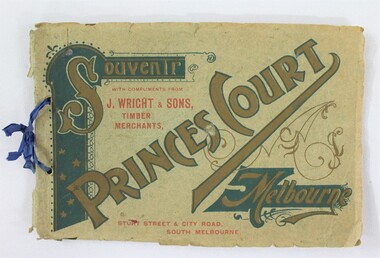 Wodonga & District Historical Society Inc
Booklet - Souvenir Booklet for Princes Court Amusement Park, Melbourne c. 1904-1905
Princes Court was an amusement park in Melbourne, located on St Kilda Road. Established in 1904, it closed its doors in 1909 after poor ticket sales due to Melbourne's temperamental weather. The park featured a toboggan ride and water chute ride where patrons inside open carriages were plunged down sloping structures from a height at great speeds. The park's other facilities and activities included a rifle range, a tug of war game, a Japanese tea house, a wine bar, a variety show, an open air cinema, and roller skating and bicycle races.This item contributes to our understanding of social life and recreation in early twentieth century Victoria. A souvenir booklet for Princes Court, an amusement park in Melbourne, printed for the years 1904-5. The booklet features photographs of the park's attractions, and advertisements for local businesses in Melbourne. wodonga, melbourne, princes park, amusement park, rides, fair, fairground, japanese tea house, st kilda -
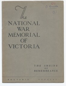 Melbourne Legacy
Booklet, The National War Memorial of Victoria. The Shrine of Remembrance. Souvenir Booklet, 1947
The booklet shows important aspects of the Shrine, 'one of the greatest of the war memorials erected in various parts of the world'. 'The purpose of this imposing structure is set out in the simple words quoted on the eastern wall of the Shrine of Remembrance itself- "This memorial was erected by a grateful people to the honoured memory of the men and women of Victoria who served the Empire in the Great War of 1914-18." The booklet outlines parts of the Shrine including the Battle Honour Discs, the Porticos, the Stone of Remembrance, the Inner Shrine, the Crypt and the Ray of Light. The document was in a file with other documents concerning the Shrine and it's history (01181 - 01190).A record of the Shrine of Remembrance. There was an effort to record historical events for the "Archive Committee" which collected this and other documents relating to the Shrine together in a file (see items 01181 - 01190)A 16 page of booklet of buff paper in a dark grey brown cover describing the Shrine in photos and black print.memorial, shrine of remembrance -
 Melbourne Legacy
Document - Document, report, (H52) The Way Ahead: a paper approved by Board of Management for dissemination to all members of the Legacy Club of Melbourne, 1979
Supplement to the Melbourne Legacy Bulletin No. 2463 which discusses how the Club should be structured after 1979, dated 27/6/79. It notes that the number of children being cared for was diminishing rapidly and immediate action should be taken with regard to the recruitment of Legatees and the adjustment of Branch boundaries. In 1978 the number of Junior Legatees had dropped to 3103 and by 1988 this figure was expected to be 280. However the 16,654 Legacy widows in 1978 was expected to increase to 24,700 in 1993. The work was split between 15 Branches, but the adjustment of Branch boundaries was not investigated in detail. Resulted from a Review CommitteeIllustrates the changing role of Melbourne Legacy during the twentieth century.Pale blue foolscap copy paper x 4 pages, printed both sides.'H52' in blue ballpoint on first page. Date crossed out in red ballpoint.organisation structure, review committee, review, objectives -
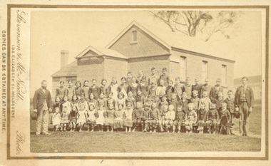 Bacchus Marsh & District Historical Society
Photograph, Coimadai State School teachers and students 1883
Coimadai is a rural community located 10km north of Bacchus Marsh. The Coimadai School was opened in 1862. It was at first entirely funded by the local residents in the area. In these early years it was known as the Pyrete School after the nearby creek of that name. The building shown in this 1883 image was constructed in 1872 and replaced an earlier wooden structure. Over time the Coimadai School became a government funded and administered school. A famous pupil to attend the school was John Cain Senior, Premier of Victoria in the 1940s and 1950s, who attended the school for one year in 1893. This school still operates as a state primary school.Small sepia unframed photograph on card with gold border framing photograph. Housed in the album, 'Photographs of Bacchus Marsh and District in 1883 by Stevenson and McNicoll'. The image is a large group portrait of the pupils of the Coimadai State School and their two male teachers. There are about 60 pupils. The older children are standing in rows and a younger group of pupils is seated on forms or benches in front of them. One teacher stands on the right of the group of pupils and the other is on the left. The School building can be seen in the background.On the front: Stevenson & McNicoll. Photo. 108 Elizabeth St. Melbourne. COPIES CAN BE OBTAINED AT ANY TIME. On the back: LIGHT & TRUTH inscribed on a banner surmounted by a representation of the rising sun. Copies of this Portrait can be had at any time by sending the Name and Post Office Money Order or Stamps for the amount of order to STEVENSON & McNICOLL LATE BENSON & STEVENSON, Photographers. 108 Elizabeth Street, MELBOURNE schools, schools coimadai vic., stevenson and mcnicoll 1883 photographs of bacchus marsh and district -
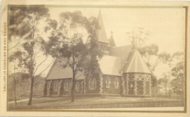 Bacchus Marsh & District Historical Society
Photograph, Holy Trinity Church Bacchus Marsh 1883
The Holy Trinity Anglican Church in this location was first opened in 1877. An earlier nearby prefabricated Church building known as the 'Iron Church' had served as the Anglican place of worship in Bacchus Marsh from around 1855 until 1877. The 1877 sandstone Church with a slate roof was intended as a permanent structure for Anglican worship in Bacchus Marsh and still stands in 2024 and continues to function as an Anglican Church. The building was designed by Frederick Wyatt and is described as early English Gothic in style. It was opened on 5 June 1877 by Bishop Moorhouse of Melbourne. The sandstone was acquired from Grant's quarry at Maddingley.Small sepia unframed photograph on card with gold border framing photograph. Housed in the Jeremeas Family Album, which contains photographs of Bacchus Marsh and District in 1883 by Stevenson and McNicoll. The photograph depicts the recently constructed Anglican Holy Trinity Church in Gisborne Road, Bacchus Marsh. The view of the building is from Gisborne Road looking west. From this angle the rear and southern side of the building can be seen. A picket fence along the entrance to the Church grounds can be seen in the foreground.On the front: Stevenson & McNicoll. Photo. 108 Elizabeth St. Melbourne. COPIES CAN BE OBTAINED AT ANY TIME. On the back: LIGHT & TRUTH inscribed on a banner surmounted by a representation of the rising sun. Copies of this Portrait can be had at any time by sending the Name and Post Office Money Order or Stamps for the amount of order to STEVENSON & McNICOLL LATE BENSON & STEVENSON, Photographers. 108 Elizabeth Street, MELBOURNE churches bacchus marsh, holy trinity anglican church bacchus marsh, holy trinity church of england bacchus marsh, stevenson and mcnicoll 1883 photographs of bacchus marsh and district