Showing 2020 items matching "the place between"
-
 Eltham District Historical Society Inc
Photograph, 14 Stokes Place, Eltham, April 1980, 1980
14 Stokes Place was the home of Peter and Carla Vermey. The land was purchased in May 1979 and the home built by Peter and Carla Vermey after the developer, Macquarie Builders went bankrupt. Sold October 2017 by Morrison and Kleeman Real Estate. Stokes Place was part of the Stokes Orchard Estate which was developed from the break-up of the the orchard owned by Frank Stokes who lived on the northeast corner of Nyora Road and Eucalyptus Road. His daughter Beryl advised that the Shire had levied a rate assessment on individual parcels of land within the orchard which became unaffordable resulting in its sub-division and sell off. The Stokes Orchard Estate was developed by Macquarie Builders in two stages starting with stage 1 in 1976. Stokes Place was part of Stage 2 in 1979. The Estate was bounded between Nyora Road, Eucalyptus Road, Diosma Road and Stokes Place. The original orchard only just reached the left most portions of Stokes Place and did not go fully up to Diosma, rather to just beyond the extant of Stokes Place. Stokes Place was known within the family as "The Oats" as that is where they grew oats. Frank Stokes moved to Eltham c.1945 after visiting Harold Bird to view his orchard, located diagonally opposite Stokes Orchard from the intersection of Eucalyptus Road, Pitt Street and Nyora Road. It was on Harold Bird's recommendation that Frank purchased the land.The Stokes Orchard Estate collection is typical of housing developments of the late 1970s and 1980s. It was one of the earliest estates in Eltham following the nearby Woodridge Estate development.Digital fileScanned from a print contained in owner's photo album (81 prints in total digitised)stokes place, eltham, stokes orchard, stokes orchard estate, streets, houses, peter and carla vermey -
 Eltham District Historical Society Inc
Photograph, 14 Stokes Place, Eltham, 1982, 1980
14 Stokes Place was the home of Peter and Carla Vermey. The land was purchased in May 1979 and the home built by Peter and Carla Vermey after the developer, Macquarie Builders went bankrupt. Sold October 2017 by Morrison and Kleeman Real Estate. Stokes Place was part of the Stokes Orchard Estate which was developed from the break-up of the the orchard owned by Frank Stokes who lived on the northeast corner of Nyora Road and Eucalyptus Road. His daughter Beryl advised that the Shire had levied a rate assessment on individual parcels of land within the orchard which became unaffordable resulting in its sub-division and sell off. The Stokes Orchard Estate was developed by Macquarie Builders in two stages starting with stage 1 in 1976. Stokes Place was part of Stage 2 in 1979. The Estate was bounded between Nyora Road, Eucalyptus Road, Diosma Road and Stokes Place. The original orchard only just reached the left most portions of Stokes Place and did not go fully up to Diosma, rather to just beyond the extant of Stokes Place. Stokes Place was known within the family as "The Oats" as that is where they grew oats. Frank Stokes moved to Eltham c.1945 after visiting Harold Bird to view his orchard, located diagonally opposite Stokes Orchard from the intersection of Eucalyptus Road, Pitt Street and Nyora Road. It was on Harold Bird's recommendation that Frank purchased the land.The Stokes Orchard Estate collection is typical of housing developments of the late 1970s and 1980s. It was one of the earliest estates in Eltham following the nearby Woodridge Estate development.Digital fileScanned from a print contained in owner's photo album (81 prints in total digitised)stokes place, eltham, stokes orchard, stokes orchard estate, streets, houses, peter and carla vermey -
 Eltham District Historical Society Inc
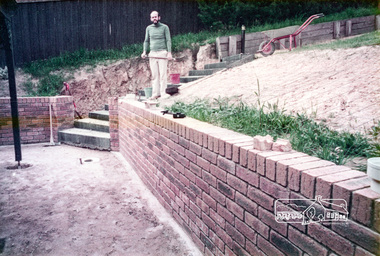
Photograph, 14 Stokes Place, Eltham, October 1983, 1980
14 Stokes Place was the home of Peter and Carla Vermey. The land was purchased in May 1979 and the home built by Peter and Carla Vermey after the developer, Macquarie Builders went bankrupt. Sold October 2017 by Morrison and Kleeman Real Estate. Stokes Place was part of the Stokes Orchard Estate which was developed from the break-up of the the orchard owned by Frank Stokes who lived on the northeast corner of Nyora Road and Eucalyptus Road. His daughter Beryl advised that the Shire had levied a rate assessment on individual parcels of land within the orchard which became unaffordable resulting in its sub-division and sell off. The Stokes Orchard Estate was developed by Macquarie Builders in two stages starting with stage 1 in 1976. Stokes Place was part of Stage 2 in 1979. The Estate was bounded between Nyora Road, Eucalyptus Road, Diosma Road and Stokes Place. The original orchard only just reached the left most portions of Stokes Place and did not go fully up to Diosma, rather to just beyond the extant of Stokes Place. Stokes Place was known within the family as "The Oats" as that is where they grew oats. Frank Stokes moved to Eltham c.1945 after visiting Harold Bird to view his orchard, located diagonally opposite Stokes Orchard from the intersection of Eucalyptus Road, Pitt Street and Nyora Road. It was on Harold Bird's recommendation that Frank purchased the land.The Stokes Orchard Estate collection is typical of housing developments of the late 1970s and 1980s. It was one of the earliest estates in Eltham following the nearby Woodridge Estate development.Digital fileScanned from a print contained in owner's photo album (81 prints in total digitised)stokes place, eltham, stokes orchard, stokes orchard estate, streets, houses, peter and carla vermey -
 Eltham District Historical Society Inc
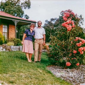
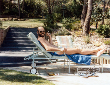
Photograph, Carla and Peter Vermey, 14 Stokes Place, Eltham, February 1984, 1980
14 Stokes Place was the home of Peter and Carla Vermey who had migrated to Australia from Holland. The land was purchased in May 1979 and the home built by Peter and Carla Vermey after the developer, Macquarie Builders went bankrupt. Sold October 2017 by Morrison and Kleeman Real Estate. Stokes Place was part of the Stokes Orchard Estate which was developed from the break-up of the the orchard owned by Frank Stokes who lived on the northeast corner of Nyora Road and Eucalyptus Road. His daughter Beryl advised that the Shire had levied a rate assessment on individual parcels of land within the orchard which became unaffordable resulting in its sub-division and sell off. The Stokes Orchard Estate was developed by Macquarie Builders in two stages starting with stage 1 in 1976. Stokes Place was part of Stage 2 in 1979. The Estate was bounded between Nyora Road, Eucalyptus Road, Diosma Road and Stokes Place. The original orchard only just reached the left most portions of Stokes Place and did not go fully up to Diosma, rather to just beyond the extant of Stokes Place. Stokes Place was known within the family as "The Oats" as that is where they grew oats. Frank Stokes moved to Eltham c.1945 after visiting Harold Bird to view his orchard, located diagonally opposite Stokes Orchard from the intersection of Eucalyptus Road, Pitt Street and Nyora Road. It was on Harold Bird's recommendation that Frank purchased the land.The Stokes Orchard Estate collection is typical of housing developments of the late 1970s and 1980s. It was one of the earliest estates in Eltham following the nearby Woodridge Estate development.Digital fileScanned from a print contained in owner's photo album (81 prints in total digitised)stokes place, eltham, stokes orchard, stokes orchard estate, streets, houses, peter and carla vermey -
 Eltham District Historical Society Inc
Photograph, Carla and Peter Vermey, 14 Stokes Place, Eltham, March 1984, 1980
14 Stokes Place was the home of Peter and Carla Vermey who had migrated to Australia from Holland. The land was purchased in May 1979 and the home built by Peter and Carla Vermey after the developer, Macquarie Builders went bankrupt. Sold October 2017 by Morrison and Kleeman Real Estate. Stokes Place was part of the Stokes Orchard Estate which was developed from the break-up of the the orchard owned by Frank Stokes who lived on the northeast corner of Nyora Road and Eucalyptus Road. His daughter Beryl advised that the Shire had levied a rate assessment on individual parcels of land within the orchard which became unaffordable resulting in its sub-division and sell off. The Stokes Orchard Estate was developed by Macquarie Builders in two stages starting with stage 1 in 1976. Stokes Place was part of Stage 2 in 1979. The Estate was bounded between Nyora Road, Eucalyptus Road, Diosma Road and Stokes Place. The original orchard only just reached the left most portions of Stokes Place and did not go fully up to Diosma, rather to just beyond the extant of Stokes Place. Stokes Place was known within the family as "The Oats" as that is where they grew oats. Frank Stokes moved to Eltham c.1945 after visiting Harold Bird to view his orchard, located diagonally opposite Stokes Orchard from the intersection of Eucalyptus Road, Pitt Street and Nyora Road. It was on Harold Bird's recommendation that Frank purchased the land.The Stokes Orchard Estate collection is typical of housing developments of the late 1970s and 1980s. It was one of the earliest estates in Eltham following the nearby Woodridge Estate development.Digital fileScanned from a print contained in owner's photo album (81 prints in total digitised)stokes place, eltham, stokes orchard, stokes orchard estate, streets, houses, peter and carla vermey -
 Eltham District Historical Society Inc
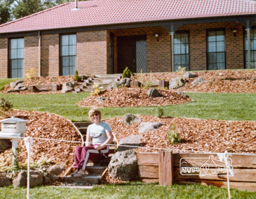
Photograph, 14 Stokes Place, Eltham, March 1984, 1980
14 Stokes Place was the home of Peter and Carla Vermey who had migrated to Australia from Holland. The land was purchased in May 1979 and the home built by Peter and Carla Vermey after the developer, Macquarie Builders went bankrupt. Sold October 2017 by Morrison and Kleeman Real Estate. Stokes Place was part of the Stokes Orchard Estate which was developed from the break-up of the the orchard owned by Frank Stokes who lived on the northeast corner of Nyora Road and Eucalyptus Road. His daughter Beryl advised that the Shire had levied a rate assessment on individual parcels of land within the orchard which became unaffordable resulting in its sub-division and sell off. The Stokes Orchard Estate was developed by Macquarie Builders in two stages starting with stage 1 in 1976. Stokes Place was part of Stage 2 in 1979. The Estate was bounded between Nyora Road, Eucalyptus Road, Diosma Road and Stokes Place. The original orchard only just reached the left most portions of Stokes Place and did not go fully up to Diosma, rather to just beyond the extant of Stokes Place. Stokes Place was known within the family as "The Oats" as that is where they grew oats. Frank Stokes moved to Eltham c.1945 after visiting Harold Bird to view his orchard, located diagonally opposite Stokes Orchard from the intersection of Eucalyptus Road, Pitt Street and Nyora Road. It was on Harold Bird's recommendation that Frank purchased the land.The Stokes Orchard Estate collection is typical of housing developments of the late 1970s and 1980s. It was one of the earliest estates in Eltham following the nearby Woodridge Estate development.Digital fileScanned from a print contained in owner's photo album (81 prints in total digitised)stokes place, eltham, stokes orchard, stokes orchard estate, streets, houses, peter and carla vermey -
 Eltham District Historical Society Inc
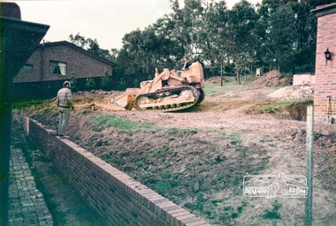
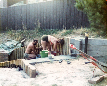
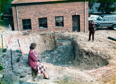
Photograph, Swimming pool construction, 14 Stokes Place, Eltham, March 1984, 1980
14 Stokes Place was the home of Peter and Carla Vermey who had migrated to Australia from Holland. The land was purchased in May 1979 and the home built by Peter and Carla Vermey after the developer, Macquarie Builders went bankrupt. Sold October 2017 by Morrison and Kleeman Real Estate. Stokes Place was part of the Stokes Orchard Estate which was developed from the break-up of the the orchard owned by Frank Stokes who lived on the northeast corner of Nyora Road and Eucalyptus Road. His daughter Beryl advised that the Shire had levied a rate assessment on individual parcels of land within the orchard which became unaffordable resulting in its sub-division and sell off. The Stokes Orchard Estate was developed by Macquarie Builders in two stages starting with stage 1 in 1976. Stokes Place was part of Stage 2 in 1979. The Estate was bounded between Nyora Road, Eucalyptus Road, Diosma Road and Stokes Place. The original orchard only just reached the left most portions of Stokes Place and did not go fully up to Diosma, rather to just beyond the extant of Stokes Place. Stokes Place was known within the family as "The Oats" as that is where they grew oats. Frank Stokes moved to Eltham c.1945 after visiting Harold Bird to view his orchard, located diagonally opposite Stokes Orchard from the intersection of Eucalyptus Road, Pitt Street and Nyora Road. It was on Harold Bird's recommendation that Frank purchased the land.The Stokes Orchard Estate collection is typical of housing developments of the late 1970s and 1980s. It was one of the earliest estates in Eltham following the nearby Woodridge Estate development.Digital fileScanned from a print contained in owner's photo album (81 prints in total digitised)stokes place, eltham, stokes orchard, stokes orchard estate, streets, houses, peter and carla vermey -
 Eltham District Historical Society Inc
Photograph, 14 Stokes Place, Eltham, June 1986, 1980
14 Stokes Place was the home of Peter and Carla Vermey who had migrated to Australia from Holland. The land was purchased in May 1979 and the home built by Peter and Carla Vermey after the developer, Macquarie Builders went bankrupt. Sold October 2017 by Morrison and Kleeman Real Estate. Stokes Place was part of the Stokes Orchard Estate which was developed from the break-up of the the orchard owned by Frank Stokes who lived on the northeast corner of Nyora Road and Eucalyptus Road. His daughter Beryl advised that the Shire had levied a rate assessment on individual parcels of land within the orchard which became unaffordable resulting in its sub-division and sell off. The Stokes Orchard Estate was developed by Macquarie Builders in two stages starting with stage 1 in 1976. Stokes Place was part of Stage 2 in 1979. The Estate was bounded between Nyora Road, Eucalyptus Road, Diosma Road and Stokes Place. The original orchard only just reached the left most portions of Stokes Place and did not go fully up to Diosma, rather to just beyond the extant of Stokes Place. Stokes Place was known within the family as "The Oats" as that is where they grew oats. Frank Stokes moved to Eltham c.1945 after visiting Harold Bird to view his orchard, located diagonally opposite Stokes Orchard from the intersection of Eucalyptus Road, Pitt Street and Nyora Road. It was on Harold Bird's recommendation that Frank purchased the land.The Stokes Orchard Estate collection is typical of housing developments of the late 1970s and 1980s. It was one of the earliest estates in Eltham following the nearby Woodridge Estate development.Digital fileScanned from a print contained in owner's photo album (81 prints in total digitised)stokes place, eltham, stokes orchard, stokes orchard estate, streets, houses, peter and carla vermey -
 Eltham District Historical Society Inc
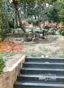
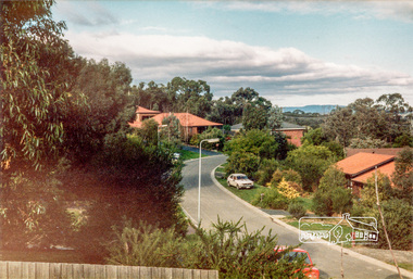
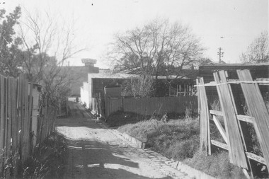
Photograph, Stokes Place, Eltham, June1986; looking southeast from linear park reserve near no. 10, 1980
14 Stokes Place was the home of Peter and Carla Vermey who had migrated to Australia from Holland. The land was purchased in May 1979 and the home built by Peter and Carla Vermey after the developer, Macquarie Builders went bankrupt. Sold October 2017 by Morrison and Kleeman Real Estate. Stokes Place was part of the Stokes Orchard Estate which was developed from the break-up of the the orchard owned by Frank Stokes who lived on the northeast corner of Nyora Road and Eucalyptus Road. His daughter Beryl advised that the Shire had levied a rate assessment on individual parcels of land within the orchard which became unaffordable resulting in its sub-division and sell off. The Stokes Orchard Estate was developed by Macquarie Builders in two stages starting with stage 1 in 1976. Stokes Place was part of Stage 2 in 1979. The Estate was bounded between Nyora Road, Eucalyptus Road, Diosma Road and Stokes Place. The original orchard only just reached the left most portions of Stokes Place and did not go fully up to Diosma, rather to just beyond the extant of Stokes Place. Stokes Place was known within the family as "The Oats" as that is where they grew oats. Frank Stokes moved to Eltham c.1945 after visiting Harold Bird to view his orchard, located diagonally opposite Stokes Orchard from the intersection of Eucalyptus Road, Pitt Street and Nyora Road. It was on Harold Bird's recommendation that Frank purchased the land.The Stokes Orchard Estate collection is typical of housing developments of the late 1970s and 1980s. It was one of the earliest estates in Eltham following the nearby Woodridge Estate development.Digital fileScanned from a print contained in owner's photo album (81 prints in total digitised)stokes place, eltham, stokes orchard, stokes orchard estate, streets, houses, peter and carla vermey -
 Eltham District Historical Society Inc
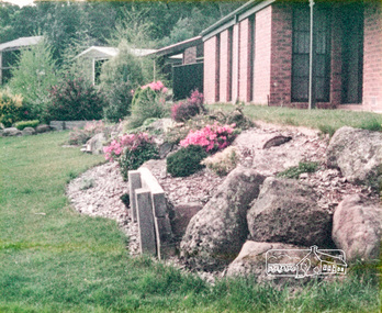
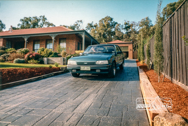
Photograph, 14 Stokes Place, Eltham, March 1987, 1980
14 Stokes Place was the home of Peter and Carla Vermey who had migrated to Australia from Holland. The land was purchased in May 1979 and the home built by Peter and Carla Vermey after the developer, Macquarie Builders went bankrupt. Sold October 2017 by Morrison and Kleeman Real Estate. Stokes Place was part of the Stokes Orchard Estate which was developed from the break-up of the the orchard owned by Frank Stokes who lived on the northeast corner of Nyora Road and Eucalyptus Road. His daughter Beryl advised that the Shire had levied a rate assessment on individual parcels of land within the orchard which became unaffordable resulting in its sub-division and sell off. The Stokes Orchard Estate was developed by Macquarie Builders in two stages starting with stage 1 in 1976. Stokes Place was part of Stage 2 in 1979. The Estate was bounded between Nyora Road, Eucalyptus Road, Diosma Road and Stokes Place. The original orchard only just reached the left most portions of Stokes Place and did not go fully up to Diosma, rather to just beyond the extant of Stokes Place. Stokes Place was known within the family as "The Oats" as that is where they grew oats. Frank Stokes moved to Eltham c.1945 after visiting Harold Bird to view his orchard, located diagonally opposite Stokes Orchard from the intersection of Eucalyptus Road, Pitt Street and Nyora Road. It was on Harold Bird's recommendation that Frank purchased the land.The Stokes Orchard Estate collection is typical of housing developments of the late 1970s and 1980s. It was one of the earliest estates in Eltham following the nearby Woodridge Estate development.Digital fileScanned from a print contained in owner's photo album (81 prints in total digitised)stokes place, eltham, stokes orchard, stokes orchard estate, streets, houses, peter and carla vermey -
 Eltham District Historical Society Inc
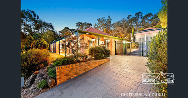
Photograph, 14 Stokes Place, Eltham, September 2017 (Advertising material photos; Morrison Kleeman Real Estate), 2017
14 Stokes Place was the home of Peter and Carla Vermey who had migrated to Australia from Holland. The land was purchased in May 1979 and the home built by Peter and Carla Vermey after the developer, Macquarie Builders went bankrupt. Sold October 2017 by Morrison and Kleeman Real Estate. Stokes Place was part of the Stokes Orchard Estate which was developed from the break-up of the the orchard owned by Frank Stokes who lived on the northeast corner of Nyora Road and Eucalyptus Road. His daughter Beryl advised that the Shire had levied a rate assessment on individual parcels of land within the orchard which became unaffordable resulting in its sub-division and sell off. The Stokes Orchard Estate was developed by Macquarie Builders in two stages starting with stage 1 in 1976. Stokes Place was part of Stage 2 in 1979. The Estate was bounded between Nyora Road, Eucalyptus Road, Diosma Road and Stokes Place. The original orchard only just reached the left most portions of Stokes Place and did not go fully up to Diosma, rather to just beyond the extant of Stokes Place. Stokes Place was known within the family as "The Oats" as that is where they grew oats. Frank Stokes moved to Eltham c.1945 after visiting Harold Bird to view his orchard, located diagonally opposite Stokes Orchard from the intersection of Eucalyptus Road, Pitt Street and Nyora Road. It was on Harold Bird's recommendation that Frank purchased the land.The Stokes Orchard Estate collection is typical of housing developments of the late 1970s and 1980s. It was one of the earliest estates in Eltham following the nearby Woodridge Estate development.Digital fileScanned from a print contained in owner's photo album (81 prints in total digitised)stokes place, eltham, stokes orchard, stokes orchard estate, streets, houses, peter and carla vermey -
 Eltham District Historical Society Inc
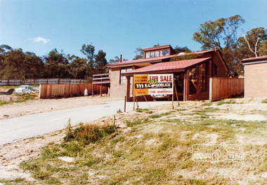
Photograph, 13 Stokes Place, Eltham, December 1980, 1980
Stokes Place was part of the Stokes Orchard Estate which was developed from the break-up of the the orchard owned by Frank Stokes who lived on the northeast corner of Nyora Road and Eucalyptus Road. His daughter Beryl advised that the Shire had levied a rate assessment on individual parcels of land within the orchard which became unaffordable resulting in its sub-division and sell off. The Stokes Orchard Estate was developed by Macquarie Builders in two stages starting with stage 1 in 1976. Stokes Place was part of Stage 2 in 1979. The Estate was bounded between Nyora Road, Eucalyptus Road, Diosma Road and Stokes Place. The original orchard only just reached the left most portions of Stokes Place and did not go fully up to Diosma, rather to just beyond the extant of Stokes Place. Stokes Place was known within the family as "The Oats" as that is where they grew oats. Frank Stokes moved to Eltham c.1945 after visiting Harold Bird to view his orchard, located diagonally opposite Stokes Orchard from the intersection of Eucalyptus Road, Pitt Street and Nyora Road. It was on Harold Bird's recommendation that Frank purchased the land.The Stokes Orchard Estate collection is typical of housing developments of the late 1970s and 1980s. It was one of the earliest estates in Eltham following the nearby Woodridge Estate development.Digital filestokes place, eltham, stokes orchard, stokes orchard estate, streets, houses -
 Orbost & District Historical Society
programs, 1961
The Snowy River Shire was a local government area in the Australian Alps region of New South Wales, Australia from 1939 until May 2016. It was named after the Snowy River that runs through it. Prior to 1936, it had been named as Dalgety Shire since establishment in 1906. This opening of the Monaro - Gippsland Road took place on 4th May 1961. There had long been a movement in Monaro for the construction of a road to connect Monaro and Gippsland, via Inglebyra and Black Mountain. The only track was for stock, made by pioneers many years ago, and it was very circuitous. It was stated at a meeting at Dalgety that the road would open up large areas for settlement for grazing, and for timber suitable for bridgé building. The road would assist stock deal ing between Monaro and Gippsland. It would also considerably shorten the distance from Victoria for tourists visiting Canberra and Kosciusko. A committee was formed to put the proposal before the Dalgety Shire Council in the 1930s.This item is a useful research tool.Four copies of a road opening program. It has black print on white. There are black / white photographs, historical details and details of the official opening.program monaro-road snowy-river-shire -
 Ringwood and District Historical Society
Document, Short history of Nunawading, c 1950
This report covers some of the eastern suburbs of Melbourne from 1834 to 1890 (approx). The early settlement of Nunawading, agricultural development, industries, residential development, institutions and hotels. Place names , churches and schools are also included4 pages of typed notes of the short history of Nunawading between 1834 and 1890 (approx) +Additional Keywords: Holland, Clisby, Williams, Riles, Polak,Schwerkolt, Smith, Rooks, Boyle, Sergeant, Matters, Ainger, Slater -
 Ringwood and District Historical Society
Document, Packet: Flora of Ringwood - reports lists and notes 1930s onwards, plus clipping 1853
Packet containing miscellaneous articles and correspodence.Packet includes: . Letter from Maroondah Group for the Society for Growing AustraliannPlants to Ringwood Council outlining objections to development of Glenvale Road area from flora and fauna aspects. Dated 17/7/94. Report by Eva Buchanan on proposed subdivision 94/112- Glenvale Road area dated August 1994. . Correspondence between Jack Lundy, Mrs Pullin and Bryan Tonkin re bulbs. . Miscellaneous documents on the Flora of Ringwood. . Typed notes- Eucalypts of Ringwood, Plants and Fungi of Ringwood, Birds of Ringwood area, Plants of Mitcham area, Wattles of Ringwood. (Refer also to "Ringwood- Place of Many Eagles" book, Appendix IV: Ringwood Natural History by F.J.C. Rogers, pages 241 to 268). -
 Orbost & District Historical Society
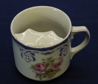
moustache cup, late 19th - first half 20th century
... to the moustache to keep it nice and stiff, with every hair in place ...The moustache cup is a drinking cup with a semicircular ledge inside. The ledge has a half moon-shaped opening to allow the passage of liquids and serves as a guard to keep moustaches dry. It is generally acknowledged to have been invented in the 1860s by British potter Harvey Adams (born 1835). Moustaches flourished throughout the Victorian era. Men often applied great gobs of melted wax to the moustache to keep it nice and stiff, with every hair in place.Between 1920 and 1930, moustaches progressively began to go out of fashion and hence moustache cup production gradually dwindled. This cup is an example of a common domestic item of its time. The Nixon families were among the earliest settlers on the Snowy River.A drinking cup with a semi-circular ledge inside - a moustache cup. It is white with a mauve stencilled border design and pink roses in the centre.Bottom - 34 472/5moustache-cup china domestic-items crockery -
 Orbost & District Historical Society
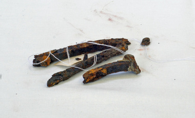
nails, between 1833 and 1877
The Isle of the Dead is located in the harbour off Port Arthur. Between 1833 and 1877, around one thousand burials took place thereThree home-made nails.port-arthur nails isle-of-the-dead -
 Orbost & District Historical Society
black and white photographs, 1934
These photographs were taken just after the McKillop's Bridge was completed after the flood damage. The current McKillop’s Bridge was built by the Country Roads Board in two stages between 1931-36, during which its height was raised after the original bridge superstructure was washed away in record floods of January 1934, prior to its original official opening. In its reconstructed form the original concrete abutments were turned into additional piers and the welded-steel trusses were cantilevered back over them to meet the new higher road approaches. It is sited at McKillops Crossing, named after pioneer overlanding squatter George McKillop who crossed here in 1835. This was a stock crossing place for almost a century before the bridge was constructed. (info. from Victoria Heritage Register)This is a pictorial record of the history of McKillop's Bridge, in itself of historical significance for its association with Victoria's long and important pastoral history, its technicl significance and aesthetic significance.Three black / white photographs. 3133.1 shows the approach to a washed away bridge. 3133.2 is of a bridge over a river with men clearing debris. 3133.3 is a close-up showing the wreckage of the bridge.mckillop's-bridge snowy-river flood-damage-1934 -
 Ringwood and District Historical Society
Photographs, 1979-80 MMBW pipe line project at Hubbard Reserve, North Ringwood � Last days of the boring
Part of a 43-photo record of the MMBW�s engineering feat in drilling a 12 inch pipe line up to 40 feet deep through rock hardened by volcanic action associated with geological fault that occurs along the line. The work took place from October 1979 to May 1980 on the southern boundary of Hubbard Reserve, North Ringwood. The collection was presented to the Ringwood Historical Research Group by J Clarke on 9th June 1980.E561 N1 1 April 1980 A43 Last days of the boring. The mole had broken between the last two shafts. Dominic Di Nezza and Glen Pearson discuss further moves to release it. -
 Ringwood and District Historical Society
Photograph, Former Ringwood Mail office, Adelaide Street, 1955 looking along laneway to west showing Ham's Billiard Saloon to left, 1955
This laneway which ran between Bamford's Timber Yard on the corner of Warrandyte Rd and Maroondah Hwy became Civic Place. Two storey building is Renong Chambers. Bottom left shows Jack Orr's clothes hoists. Bottom right is Horman & Woolhouse plumbers. This area was demolished in 1965.Typed below photograph, "Former Ringwood Mail office, Adelaide Street, 1955". Catalogue card reads, "Adelaide St. looking along laneway to west showing former "Mail" office and Billiards Pool to left, 1955." Written on backing sheet of one copy, "Lane between Bamford's Timber Yard, corner Warrandyte Rd. and Maroondah Highway. House demolished 1965. 'Ringwood Mail' office at end of lane in Adelaide St." Another copy's backing sheet reads, "Mail Office. Lane went to Melbourne St. Ham's Billiard Saloon, Renong Chambers (2 storey) bot. left Jack Orr's clothes hoists. Bot. right Horman & Woolhouse plumbers." Another copy reads, "This laneway became Civic Place." -
 Ringwood and District Historical Society
Photograph, Laneway between Adelaide Street and Warrandyte Road, looking towards S.E. Dickens supermarket on the corner of Civic Place. Ringwood, 1962
Black and white photograph of laneway. Dilapidated paling fences either side in foreground.On reverse of one photo: "Laneway from opp. Civic Pl. in Adelaide St to W'dyte Rd. 1962. Ringwood Historical Research Group" -
 Orbost & District Historical Society
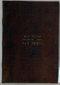
account book, BETE BOLONG DRAINAGE AREA PAY SHEET, 1910 - 1913
This account book was used by the Orbost Shire council to record payments made for work done on the Bete Bolong Drainage Area between 1910 and 1913. The item was donated to Orbost & District Historical society from P.R.O.V. as a Place of Deposit (POD) item for safe keeping by a local history group or museum. The shire covered an area of 9,347 square kilometres and existed from 1892 until 1994 when it became part of the East Gippsland Shire Council. Orbost was at first included in the Bairnsdale Shire from 1882 and was later part of the Tambo Shire. Because of travelling distances the Croajingalong Shire was created in 1892 (name changed to Orbost Shire 17.2.1893 with James Cameron as the first Shire President. In 1994 it amalgamated to become part of East Gippsland Shire Council. This item is a hand-written record of the accounts of the local government. The Orbost Shire Council no longer exists having been absorbed by the East Gippsland Shire Council.A brown leatherette, hard cover book. In gold lettering on the front is "BETE BOLONG DRAINAGE AREA PAY SHEET". It contains records of payments made for work done 1910-1913.In gold lettering on the front is "BETE BOLONG DRAINAGE AREA PAY SHEET".bete-bolong-drainage-area accounts orbost-shire -council -
 Cheese World Museum
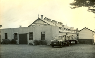
Photograph, Kraft Walker Cheese Pty Ltd Garvoc Branch factory, c1940
The Kraft Walker Cheese Co Pty Ltd entered into an agreement with Warrnambool Cheese and Butter Factory Company in 1935 whereby the Kraft company leased premises from WCB. This arrangement remained in place until the 1990s. WCB took over the Garvoc factory in the 1920s. It became outdated and was eventually demolished.Black and white photograph showing timbered building with iron roof and turned wooden finial on the gable end. There are three timber ventilation ducts on the roof. The gable end has sign Kraft Walker Cheese Co Pty Ltd Garvoc Branch. A concrete block addition is at the front. A tray truck with milk cans is in between the main factory building and the outbuilding.garvoc, allansford, dairy industry, food manufacture, kraft walker cheese company, factories, cheese, kraft foods ltd, transport, milk cans -
 Cheese World Museum
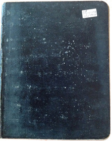
Book, laboratory notes
Kraft Walker commenced cheese processing at Allansford in 1935 under a lease arrangement with Warrnambool Cheese and Butter Factory. This arrangement remained in place until Kraft officially ceased bulk cheese production at Allansford in February 1993. Kraft was responsible for farm collection of milk which was then shared between the two companies -Kraft for bulk cheese manufacture and Warrnambool Cheese and Butter Factory for whole milk, milk powder and butter manufacture. Laboratory technicians tested milk and cheese during the receival and manufacturing processes to ensure a high quality product. Derek Shaw, whose notebook this is, was the first person in charge of the Kraft Allansford laboratory. He kept notes of testing undertaken and recorded results of anything considered unusual. This notebook is one in a series of 33. Les O'Callaghan commenced work in the laboratory as Derek Shaw's assistant and technician in charge following Derek's retirement. He too kept notebooks of test results.Kraft laboratory technician/bio-chemist Les O'Callaghan was responsible for the introduction of a number of quality control measures which are still in use in the dairy industry today. Les was mentored by Derek Shaw. This note book provides an insight into the dairy processing industry at this period.Black exercise book with lined pages; white sticker on front cover showing dates usedLH/ 17/11/1938 / 2/5/1939allansford, dairy industry, dairy processors, cheese making, kraft foods ltd, warrnambool cheese and butter factory company -
 Flagstaff Hill Maritime Museum and Village
Chest of drawers, early 20th century
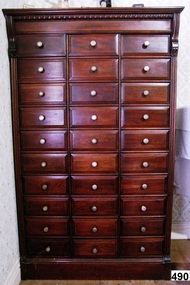
This medical bureau / cabinet shows several signs of being used for a different purpose before being a medical bureau. It once had the words "GENUINE PURE QUALITY" lettered across the top of the front, as can been still seen from the impression left behind in the stained timber. On each drawer above the handle is a faint impression of something long and rectangular, as though there had been a label attached. The front panel of the drawers is made of the same wood as the rest of the outer cabinet, most probably blackwood. The handles on the drawers are not the original handles either. There are 3 filled-in holes that would form the corners of a triangle, apex at the top, around the perimeter of the current handles. The sides of the drawers are made from plywood and the base made from alternating lengthwise strips of oak and beech wood pressed together, rounded corners at the back and joined to the front panel with metal brackets. The backs of the base of the drawers have four round impressions in them. Along the back edge of the base, in the centre, is a rectangular hole. Between the front pair of round holes is a faint black rounded marking, like the impression made by rubber. The cabinet may have once been a filing cabinet, with the drawers used as document drawers, each with a spring-loaded clamp attached to the back of them to secure documents within. The original handles could have been the half-cup type used for filing cabinets. The construction and use of plywood could place this cabinet in about 1950's.Chest of drawers (or Medical Bureau, or Apothecary Chest, or Filing Cabinet) wooden, dark stained, with 30 small drawers (10 rows, 3 columns). The outer wood of cabinet is possibly blackwood and the edges of top and sides have carved wood decoration. Drawer fronts have bevelled edges and round silver-coloured metal knobs. Drawers have plywood sides, and oak and beech wood bases/, Each drawer has four round depressions (in a square-shaped arrangement) at the back plus a small rectangular hole cut in the centre back of base. A faint impression from previous lettering is evident in the wood stain across top front of cabinet.Impression of previous lettering across top front of cabinet "GENUINE PURE QUALITY". flagstaff hill, warrnambool, shipwrecked coast, flagstaff hill maritime museum, maritime museum, shipwreck coast, flagstaff hill maritime village, great ocean road, drawers, bureau, cabinet, chest of drawers, furniture, bedroom furniture, household storage, medical bureau, apothecary cabinet, document drawers, filing cabinet -
 Flagstaff Hill Maritime Museum and Village
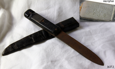
Weapon - Knife, Made on or before September 1891
This sheath knife belonging originally to German seaman Julius Gebauhr and an artifact associated with the story of the survivors of the wreck of Fiji. A three-masted iron barque Fiji had been built in Belfast, Ireland, in 1875 by Harland and Wolfe for a Liverpool based shipping company. The ship departed Hamburg on 22nd May 1891 bound for Melbourne, under the command of Captain William Vickers with a crew of 25. The ship’s manifest shows that she was loaded with a varied cargo consisting of cases of dynamite, pig iron, steel goods, various spirits, sailcloth, tobacco, coiled fencing wire, concrete, 400 German pianos and other musical instruments. On September 5th, one hundred days out from Hamburg in a squally and boisterous south-west wind, the Cape Otway light was sighted on a bearing differing from Captain Vickers' calculation of his position. At about 2:30 am, Sunday 6th September 1891 land was reported 4-5 miles off the port bow. The captain tried to put the ship on the other tack, but she would not respond. He then tried to turn her the other way but just as the manoeuvre was being completed Fiji struck rock only 274 meters from shore. The place is known as Wreck Bay, Moonlight Head. Efforts were made to lower boats but all capsized or became swamped two of the younger crewmen volunteered to swim for the shore, taking a line. One, a Russian named Daniel Carkland, drowned after the line broke. The other, 17-year-old able seaman Julius Gebauhr, a German, reached shore safely on his second attempt without a line, which he had cut loose with his sheath-knife when it becomes tangled in kelp. He rested on the beach a while then climbed the cliffs in search of help. At about 10 am on Sunday a party of land selectors including F. J. Stanmore, Leslie Dickson found Gebauer. They were on their travels back from Princetown towards Moonlight Head. Gebauer was lying in the scrub in a poor state, bleeding and dressed only in a singlet, socks, belt and his sheath-knife. His rescues gave him food and brandy and some clothing and gain information about the wreck. Some of the men took him to Rivernook, a nearby guest house owned by John Evans, where he was cared for. Stanmore and Dickson rode off to try and summon help. Messages for rescuing the rest of the crew were sent both to Port Campbell for the rocket rescue crew and to Warrnambool for the lifeboat. The S.S. Casino sailed from Portland towards the scene. After travelling the 25 miles to the scene, half of the Port Campbell rocket crew and equipment arrived and was set up on the beach below the cliffs. By this time the crew of Fiji had been clinging to the jib-boom for almost 15 hours. Mr Tregear from the Rocket Crew fired the line the light line broke and the rocket was carried away. A second line was successfully fired across the ship and made fast. The anxious sailors then attempted to come ashore along the line but, as many as five at a time, however, some were washed off. Only 14 of the 24 men who had remained on the ship made it to shore. Many onlookers on the beach took it in turns to go into the surf and drag half-drowned seamen to safety. The wreck of Fiji has smashed apart within 20 minutes of the last man being brought ashore, and it settled in about 6 m of water. Of the 26 men on Fiji, 11 in total lost their lives. The remains of 7 bodies were washed onto the beach. They were buried on the clifftop above the wreck. Captain Vickers was severely reprimanded for his mishandling of the ship and his Masters Certificate was suspended for 12 months. At the time there was a great deal of public criticism at the slow and disorganised rescue attempt to save those on board. The important canvas ‘breech buoy’ or ‘bucket chair’ and the heavy line from the Rocket Rescue was in the half of the rocket outfit that didn’t make it in time for the rescue: they had been delayed at the Gellibrand River ferry. Communications to Warrnambool were down so the call for help didn’t get through on time and the two or three boats that had been notified of the wreck failed to reach it in time. Captain Vickers presented Bill Robe who had dragged the captain out of the surf with his silver cased pocket watch, the only possession that he had left, as a token for having saved his life and the lives of some of the crew. Years later Bill passed the watch to his brother in law Gilbert Hulands as payment of a debt. Since that time it has been passed down the family to Gilbert Hulands’ grandson, John Hulands. Seaman Julius Gebauhr later gave his knife, in its hand crafted leather sheath, to F. J. Stanmore for caring for him when he came ashore. The knife handle has a personal inscription on it. A marble headstone on the 200 m high cliffs overlooking Wreck Beach, west of Moonlight Head, paying tribute to the men who lost their lives when Fiji ran aground. The scene of the wreck is marked by the anchor from the Fiji, erected by Warrnambool skin divers in 1967. Amongst the artefacts salvaged from the Fiji are china miniature animals, limbs from small china dolls, rubber balls, a glass bottle, sample of rope from the distress rocket and a candlestick holder. These items are now part of the Fiji collection at Flagstaff Hill Maritime Museum, along with this sheath knife and Captain Vickers’ pocket watch. Flagstaff Hill’s collection from the wreck of the Fiji and Julius Gebauhr knife is of historical significance at a State level because of its association with the vessel, which is on the Victorian Heritage Register (VHR S 259). The Fiji is archaeologically significant as the wreck of a typical 19th-century international sailing ship with cargo. It is educationally and recreationally significant as one of Victoria's most spectacular historic shipwreck dive sites with structural features and remains of the cargo still evident. Also the story of the heroic attempt by many to save the crew of the Fiji. The knife also represents an aspect of shipping history and fits in well with Victoria's framework of historical themes of living with natural processes as items such as these contribute to a better understanding of Victoria’s cultural history.Knife, metal with black wooden handle. Handle is riveted to knife in 3 places, with shaft of knife between the 2 parts of the handle. The handle also has a carved ring around the end, possibly for attaching a wrist strap. Knife blade is pointed in the centre of the tip and is rusty. The knife has a rectangular metal plaque on handle with inscription. The hand crafted dark brown, soft leather sheath is shaped to fit the knife and joined at the back with cross stitching. The sheath also has a leather belt strap that has come away from the sheath at one end.Metal plaque “FROM JULIUS GEBAUHR/”FIJI” /TO F.J.S.” (F J Standmore recipient)1891, shipwrecked coast, flagstaff hill, flagstaff hill maritime museum, maritime museum, shipwrecked artefact, flagstaff hill maritime village, shipwreck coast, warrnambool, knife, fiji, pocket watch, moonlight head, gebauhr, stansmore, wreck bay, sheath knife -
 Flagstaff Hill Maritime Museum and Village
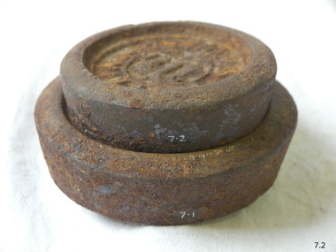
Equipment - Weight
The disc-shaped design of these 1LB and 2 LB metal weights enables them to be stacked one on top of the other. The weights are used with a balance scale to accurately weigh the mass of items such as grain, sugar, meat or potatoes. They could have been used in retail or wholesale businesses like a general store or a grain merchant’s premises. The user would place either one or both of these weights on one side of a balance scale. Goods would then be placed onto the other side of the scale until the beam between both sides of the scale was level, showing that the weight of the goods was as heavy as the weight or weights on the other side. These two weights are marked in Imperial units. An Imperial Standard 1LB is equal to 453.592grams. The British Weights and Measures Act of 1824 defined official standards for weights and measurements. This ensured that uniform measurements would be used for trade throughout the Empire. Towns and districts would have an official set of Imperial Standard Weights and Measures. Inspectors periodically used this official set to check the accuracy of traders’ own weights and measures. There would be penalties such as fines or imprisonment for people who broke these laws. The State of Victoria had its own Weight and Measures Act in 1862 and a decade later the inspectors in local councils used their local set of weights and measures to test the local businesses measuring equipment. In the nineteenth century the Victorian Customs Department carried out this role but this was handed over to the Melbourne Observatory at the beginning of the twentieth century. The Measures Branch then followed on with this task from the 1940s until 1995. Australia began converting to the metric system in the 1960s, beginning with its money. The conversion from imperial to metric units of measurement in Australia took place from 1970 and was completed in 1988 when metric units became the only legal unit of measurement. Imperial Standard weights; set of two disc-shaped weights designed to stack one upon the other. Inscriptions are marked in relief. "IMPERIAL STANDARD 1LB" [weight 1], "IMPERIAL STANDARD 2LB" [weight 2]warrnambool, shipwrecked-coast, flagstaff-hill, flagstaff-hill-maritime-museum, maritime-museum, shipwreck-coast, flagstaff-hill-maritime-village, shipwrecked-artefact, wieght, weights and measures, imperial standard weight -
 Flagstaff Hill Maritime Museum and Village
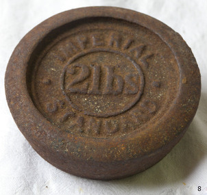
Equipment - Weight
The disc-shaped design of this 2 LB metal weight enables it to be stacked on top of another similarly shaped weight. The weight is used with a balance scale to accurately weigh the mass of items such as grain, sugar, meat or potatoes. It could have been used in retail or wholesale businesses like a general store or a grain merchant’s premises. The user would place the weight on one side of a balance scale. Goods would then be placed onto the other side of the scale until the beam between both sides of the scale was level, showing that the weight of the goods was as heavy as the weight on the other side. This weight is marked in Imperial units. An Imperial Standard 1LB, or one pound, is equal to 453.592grams. The British Weights and Measures Act of 1824 defined official standards for weights and measurements. This ensured that uniform measurements would be used for trade throughout the Empire. Towns and districts would have an official set of Imperial Standard Weights and Measures. Inspectors periodically used this official set to check the accuracy of traders’ own weights and measures. There would be penalties such as fines or imprisonment for people who broke these laws. The State of Victoria had its own Weight and Measures Act in 1862 and a decade later the inspectors in local councils used their local set of weights and measures to test the local businesses measuring equipment. In the nineteenth century the Victorian Customs Department carried out this role but this was handed over to the Melbourne Observatory at the beginning of the twentieth century. The Measures Branch then followed on with this task from the 1940s until 1995. Australia began converting to the metric system in the 1960s, beginning with its money. The conversion from imperial to metric units of measurement in Australia took place from 1970 and was completed in 1988 when metric units became the only legal unit of measurement.Weight; 2 lbs. Metal disc designed for stacking. Inscription marked in relief. Imperial Standard weight, 2 pounds weight."IMPERIAL STANDARD", "2lbs"flagstaff hill, warrnambool, shipwrecked coast, flagstaff hill maritime museum, maritime museum, shipwreck coast, flagstaff hill maritime village, great ocean road, standard measure, imperial standard, weight, 2lb weight, imperial standard weight