Showing 29073 items
matching $10
-
 University of Melbourne, Burnley Campus Archives
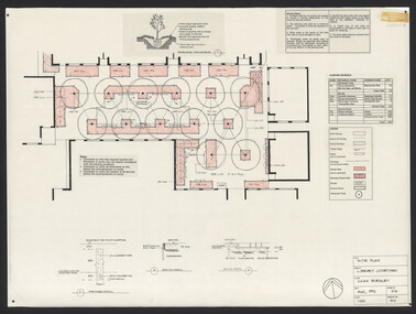
Plan, Steve Mullany, Classroom Quadrangle/Library Courtyard, 1985-1999
Various plans. (1) Photocopy of Section A-A, 1985 and 1 photocopy of part of plan. (2) Tracing paper copy, Construction Plan Classroom/Library Quadrangle Feb. 1986. (3) Master Plan, coloured and detailed and 1 copy not detailed, Classroom Quadrangle Landscape Redevelopment by S. Mullany, 10 August 1988. (4) 4 tracing paper and 2 paper copies Set of Plans Library Courtyard Aug 1992 by KW. (5) Miscellaneous sketches. (6) Assessment task. (7) Sketch Proposal Quad Entry by M. Green May 1995. (8) Quadrangle Steps Redevelopment 7/12/99 by Phil Tulk. (9) Tracing paper and paper copies Quadrangle Steps Redevelopment by JK 20.12.99.classroom, library, courtyard, steve mullany, quadrangle, landscape design, steps -
 The Beechworth Burke Museum Research Collection
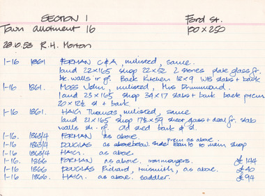
Card (Series) - Index Card, George Tibbits, Ford Street, Beechworth, 1976
George Tibbits, University of Melbourne. Faculty of Architecture, Building and Town & Regional PlanningIndex system that support the research for Beechworth : historical reconstruction / [by] George Tibbits ... [et al]Arranged by street names of BeechworthEach index card includes: street name and number of property, image of property, allotment and section number, property owners and dates of ownership, description of the property according to rate records, property floor plan with dimensions.beechworth, george tibbitsbeechworth, george tibbits -
 The Beechworth Burke Museum
Audio - Oral History, Jennifer Williams, Mr Bill Gerrard, 10 August 2000
Bill Gerrard was born in Albury in 1934 and moved to Beechworth in 1960 when his wife was employed as a nurse at Mayday Hills Hospital, later becoming nurse-in-charge. Gerrard first worked for the local railway and then as a taxi driver in Beechworth, and was involved in volunteer fund-raising activities such as raffles for charitable causes. This oral history recording was part of a project conducted by Jennifer Williams in the year 2000 to capture the everyday life and struggles in Beechworth during the twentieth century. This project involved recording seventy oral histories on cassette tapes of local Beechworth residents which were then published in a book titled: Listen to what they say: voices of twentieth century Beechworth. These cassette tapes were digitised in July 2021 with funds made available by the Friends of the Burke.Mr Bill Gerrard's account of his life in Beechworth and the local area during the mid-to-late 20th century is historically and socially significant to the cultural heritage of the region. He recounts aspects of community life and working conditions in Beechworth, particularly during the 1960s and 1970s, as well as conditions for staff and patients at Mayday Hills Hospital where his wife worked during that period. His story also provides insights into economic hardhsip and the role of voluntary fundraising in the Beechworth community. This oral history recording was part of a project conducted by Jennifer Williams in the year 2000 to capture the everyday life and struggles in Beechworth during the twentieth century. This project involved recording seventy oral histories on cassette tapes of local Beechworth residents which were then published in a book titled: Listen to what they say: voices of twentieth century Beechworth. These cassette tapes were digitised in July 2021 with funds made available by the Friends of the Burke.This is a digital copy of a recording that was originally captured on a cassette tape. The cassette tape is black with a horizontal white strip and is currently stored in a clear flat plastic rectangular container. It holds up 40 minutes of recordings on each side.Mr Bill Gerrard /listen to what they say, beechworth, oral history, burke museum, bill gerrard, mayday hills hospital, taxi driver, beechworth railway, religion, beechworth 1960s, beechworth 1970s, social welfare, community cohesion, twentieth-century working conditions, twentieth-century regional victoria, hibernian hotel, fund-raising -
 Mission to Seafarers Victoria
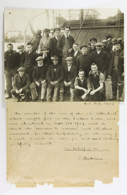
Photograph - Photograph and letter, attached, T. Bateman, The members of the crew S.S. Siltonhall 1929, 16/10/1929
This letter was written by a representative of the crew of the SS Siltonhall to the Mission to Seafarers in Oct 1929. Their ship caught fire in the Indian Ocean and were rescued by the SS Anthea. The crew was sent to Melbourne and spent some time at the Mission. Article in the Argus, Tuesday 15 October 1929, page 6 "THE SILTONHALL'S SEAMEN. TO THE EDITOR OF THE ARGUS Sir, the story of the disaster to the s.s. Siltonhall is still fresh in the public mind. The ship caught fire and she was abandoned and sank in the Indian Ocean. The crew took to the boats and were rescued and brought safely in to Melbourne. They have been with us now for nearly a week now, taking full advantage of the hospitality of the Mission to Seamen Institute.So far they have been provided with the bare necessities of one complete suit of clothing by the shipping authorities. They leave here to return home to England on Wednesday. If anyone will kindly contribute any articles of clothing or boots they will be most acceptable, especially as the men will be going to a cooler climate. Please send them to me. Yours Sincerily, HOWARD S. BAILEY, Chaplain, Missions to Seamen, Australian Wharf, Oct. 14."This letter and photograph indicate the valuable service that the Mission to Seafarers provides to crews of ships wrecked off the Australian coast. The smiling crew of the S.S. Siltonhall evidently appreciated that when they were in desperate need they were cared for. The picture was possibly taken in a nautical context, perhaps at the docks or on board a ship.B/W photograph of group of 22 men. Letter signed T. Bateman from crew of the SS Siltonhall dated Oct. 16th 1929. "Oct 16th 1929. / The members of the crew of the SS Siltonhall, / which caught fire in the Indian Ocean, and / was abandoned on Sept 21st 1929, wish to / thank the 'Missions to Seamen', and all those / concerned, for their hospitality, in the way of / Concerts, Socials, etc., also for boots and clothing / gratefully received. / On behalf of the crew. T. Bateman." photograph, letter, 1929, siltonhall, ship, crew, mission, seafarers, wreck, fire, bateman, melbourne, australia, shipwreck, reverend howard s. bailey, j. bateman -
Mission to Seafarers Victoria
Letter - Correspondence, 1/10/45
Letter from Allan Quinn to his mother written in 1945 which depicts Allan's thoughts on Adelaide.This letter is of historical, social and interpretive significance as it provides information about the life of a seaman during the mid 20th century. A single, double sided letter (0311.A1) written in 1945 and envelope (0311.B).allan quinn, mission to seafareres, 1945, letter, adelaide -
 Flagstaff Hill Maritime Museum and Village
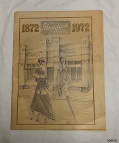
Newspaper - The Standard, Warrnambool Standard Centenary Issue 1872-1972, 02/10/1972
The Warrnambool Standard Centenary Issue, 1872 - 1972, summarises the local and world history highlights over 100 years. The pages in the images are a sample of the newspaper's contents. They show: - PAGE 1; sketches of two young women, one dressed in 1872 fashion, the other in 1972 fashion. PAGE 34; This page was dedicated to the Ponting Bros. The business celebrated its Centenary in 1972. There apr photographs of the original and the new building, and a photograph and names of the staff of 1972. PAGES 34-38: Lift out facsimile copy of the first edition of The Standard (no longer in 3096.01) PAGE 39; In January 1917 Mr Basil Watson flew the first aeroplane to visit the Warrnambool area. He entertained the crowds by performing aerobic acrobatics in the plane he'd built himself. Two months later he died in a plane accident. PAGE 70; In 1967 Australia's Prime Minister, Mr Harold Holt, goes missing, presumed drowned. PAGE 71; In 1970 the mystery of four bodies were found in a car that crashed over the cliff at Loch Ard Gorge, near Port Campbel, made headlines in the Standard. PAGE 72; The back page features a photograph and greetings from Fletcher Jones and Staff. There are many staff members in front of the Fletcher Jones factory in Warrnambool, which was established around 1924.The centennial edition of the Standard newspaper includes local social, economic and historical aspects of Warrnambool, Victoria, Australia and the World. It reflects the interests of the local community and the reactions to the events of the time.The Standard, Warrnambool, Centenary Issue 1872 – 1972 (Two copies).100 years of District Service. The issue includes World and Local History, Advertisements, Timeline, Facsimile of the First Issue, Shipwrecks, and Wars. The Centenary edition was printed on October 2, 1972, 72 pages. One copy (3096.02) includes the centre lift-out on pages 35 to 38 of a facsimile copy of the first edition published on October 1, 1872.Page 1: "The Standard Warrnambool" "Warrnambool Standard Centenary Issue October 2 1972, 72 pages" On illustration of building "1872 / Warrnambool Standard" Page 34: "On this site ... since 1924" [Ponting Bros} "Staff of Ponting Bros. 1972" Page 39: "Aviation history-maker" "RECORD TRIP BY FIRST PLANE TO VISIT CITY" "Thrilling display of aerial acrobatics" Page 70: "PM HOLT IS PRESUMED DROWNED" "GAVE GOVT. IMAGE OF YOUTH" Page 71: "Where death car crashed on ledge" "PT CAMPBELL MYSTERY: FOUR BODIES FOUND IN CAR AT BOTTOM OF CLIFF" "POLICE SEARCH SWINGS BACK TO MELBOURNE" Page 72: "Greetings to the"Standard"" "Fletcher Jones" flagstaff hill, flagstaff hill maritime museum and village, warrnambool, maritime museum, maritime village, great ocean road, shipwreck coast, ladies fashion 1872, ladies fashion 1972, ponting bros. centenary 1872-1972, ponting bros. staff, basil watson, basil watson 1917, harold holt 1967, car crash at loch ard gorge, fletcher jones and staff 1972, the standard centenary 1872-1972, warrnambool newspaper, warrnambool standard, centenary edition, the standard -
 Orbost & District Historical Society
deposit book, 17. 9. 1970; 10. 4.1978
This is a deposit book to the Commercial Bank of Australia Limited and is stamped by the Orbost Branch. It was used by the Orbost Rifle Club. The Orbost Rifle Club existed in the early 20th century. (There are records from 1900). It folded in the late 1970's.The Orbost Rifle Club was an active group for over seventy years. It no longer exists.A small thin book with a mottled tortoise shell like cover and light blue binder. accounts deposit-book-commercial-bank orbost-rifle-club -
Ringwood and District Historical Society
Book - Minute, Minutes of meetings of the Business and Professional Women's Club of Ringwood. (28-Jul-1960 - 1970), 10/30/2010
The book contains minutes of meetings of the Business and Professional Women's Club of Ringwood.Black covered book - cardboard cover. Rounded corners. Handwritten entries. The book contains minutes of meetings of the Business and Professional Women's Club of Ringwood. -
Ringwood and District Historical Society
Document - Collection, Maroondah Women's Club Ephemera, 30-Oct-10
Collection of Business and Professional Women's Clubs of MaroondahCollection of approximately 30 papers, memos, member lists, constitution(1982), handbook of Maroondah and various other Melbourne and interstate clubs. There is one photograph of Irene Mascull, Pat Clark and Audrey Lavis, celebrating a birthday at 263 Canterbury Road, Heathmont. -
Ringwood and District Historical Society
Newsletter, Enjoying Planned Retirement Newsletters June 2010, Jun-10
EPR was incorporated in December 20027 A4 pages printed double sided - News of EPR Inc Newsletter - June 2010 - Enjoying Planned Retirement +Additional Keywords: EPR / Enjoying Planned Retirement -
Ringwood and District Historical Society
Plan, SGL Consulting Group Aust Pty, Maroondah Leisure Facilities Review / Strategic Plan 2010-2050, May-10
Prepared for the Maroondah City Council, Vol one - Executive Summary of the Maroondah Leisure Facilities Review Strategic Management Plan 2010-20508 A4 double sided printed documents with black and white photos, charts & text -
 Ringwood and District Historical Society
Document, Artist Society, Ringwood Artists Group Minute Book (3 of 3). 1987-1991, 13-Jul-1987 - 10-Dec-1990
Minutes of AGMs, general meetings held at N. Ringwood Elderly Citizens rooms and committee meetings held in members homes. List of the 1989 Committee. Financial statements included for some months.Red covered Universal Account Book-Minute Indexed used from 1987-1990. loose typed minutes of Committee meeting 22 January 1991. Book 3 of 3 +Additional Keywords: Pamment, Stan (Pres) -
 Bendigo Military Museum
Letter - LETTER AND ENVELOPE, Edna Johnson, 10 April 1942
Letter was from a USA family member of a US soldier staying at a private residence in Bendigo. The US soldier was not permitted to communicate with family members as to their location. the Granger family circumvented that by sending a cable to his family and this letter was a reply to them..1) & .2) A4 page typed letter (2 pages) from Edna Johnson to Enid Granger. Black typed writing on cream coloured paper. Address on top and signed off on page 2. .3) Cream coloured envelope, address on front and six stamps. Various black stamps on front and air mail stamp address from written on back. .4) Small newspaper cut out photo of a young girl..1) Address on top - Edgemont Station, Box 241, East St, Louis, Ill, USA, April 10th 1942. .2) Signed "Sincerely Edna Johnson. .1) Address on front, Mrs Enid Granger, 32 Mt Korong Rd, Bendigo, Victoria, Australia.us soldiers, censorship, letter -
 Kiewa Valley Historical Society
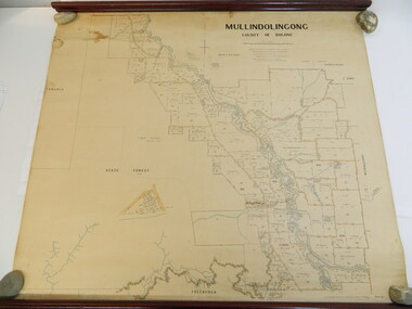
Map - Kiewa Valley, Parish Map of Mullindolingong, 12/10/1906
The map shows the names of people living in the parish of Mullindolingong in 1906. These people had leases or licences giving the reader an insight into the number of people in the area and an understanding of the size of their holdings. Infrastructure is also given including shops, schools, churches etc. Presumably it was used by the Ryder family.This map gives an historical insight into the parish of Mullindolingong as it names people and the infrastructure - roads, buildings etc. as it was in 1906. This enables the reader to compare the area at the time with other times and other places and to have an understanding of the early settlers in the area.This is a very old paper or parchment map with wooden rods top and bottom. The top rod has ribbons attached to enable hanging. The map shows the current leases and licences and when they were held by during this period, circa 1906.Mullindolingong County of Bogong. This plan has been prepared by The Most Reliable Data in the Possession of the Department up to the date of its Compilation. Information respecting Leases or Licences which await Final Completion is not recorded.parish of mullindolingong map; ryder family; early settlers; -
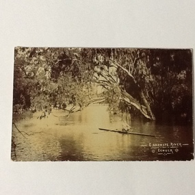 Port of Echuca
A black and white photographic postcard, Between 08/1906 - 10/1906
Photographic Postcards were very popular in the early 20th century and this shows the Campaspe river, Echuca in flood. The high water mark is exemplified by having the rower on the water. The water has inundated the surrounding bush with trees partly submerged along the right hand side of the photograph.Rowing clubs were popular in towns along the Murray river and this picturesque scene of the Campaspe river , Echuca in flood shows a man rowing a racing scull down the river.Black and white photographic postcard showing the Campaspe river, Echuca, in flood, with a man rowing a racing scull.On face : "Campaspe River, Echuca". On reverse: printed in ink :" Post Card. This space may be used for correspondence. For address only. Place penny stamp here." In pencil is written: "Aug Sep Oct 1906 Flood" "Donation H V Evans 85 Fullers Rd Chatswood NSW." " Echuca Regional Library" is stamped but has been crossed out in pen.campaspe river, echuca, echuca flood, 1906, rowing, echuca -
 Eltham District Historical Society Inc
Photograph, Jim Connor, Former CBA branch, 810 Main Rd, Eltham, 10 July 2023
The little yellow and orange brick at 810 Main Road, Eltham, just in front of the Uniting Church (formerly Methodist Church) on the corner of John Street in more recent times has been used as an Opportunity Shop by the Eltham Uniting Church however the operations outgrew the tiny building and the shop moved to inside the Church hall. This building was once the Eltham agency of the Commercial Bank of Australia. Measuring just 3.6 x 4.5 m inside, it was built in 1878 by George Stebbing and is said to have stored gold in the early Eltham-Research mining days. It was also once the scene of an armed hold-up. Thursday, December 15, 1949, the quiet little bank was embroiled in an infamous wild shoot-out between a daring thief and two bank officers. Today, the building still carries the scars ; a bullet hole remains visible in a cedar bench testifying to the events that played out that day.jim connor collection, uniting church, main road, eltham, cba bank, opportunity shop, 2023-07-10 -
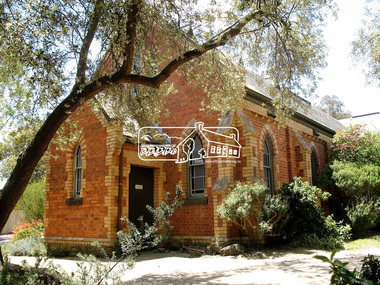
 Eltham District Historical Society Inc
Photograph, Jim Connor, Eltham - Montmorency Uniting Church, 810 Main Rd, Eltham, 10 July 2023
Located on the corner of Main Road and John Street, the church first served the community as the Eltham Wesleyan Church since 1881. It became the Eltham Methodist Church in 1902, the year it united with the Primitive Methodists. Eltham Wesleyans first worshipped together in the home of William and Mary Crozier, on 24 acres bounded by Mount Pleasant Road and Pitt Street. From there they moved to a slab and bark hut in 1855 (this later served as the first school run by David Clark prior to the building of a new school in Dalton Street) and the members then built a chapel in 1858 on Lot 20, Henry Street (later to become the Rechabite Hall and Eltham Public Hall). The present church on John Street was designed by architects Crouch and Wilson in the Early English Gothic style with biochrome brick window frames, buttress heads and pinnacle. Church member George Stebbing built the church, the foundations were constructed with stone from the walls of the first Eltham State Primary School (No. 209) building which collapsed in 1874 and were purchased by Robert David Taylor. Stebbing was also responsible for building St Margaret’s Church and Shillinglaw Cottage. The Roll of Honour, which presently hangs in the church hall (which also doubles as the Opportunity Shop) lists 27 members of the congregation who served in the First World War, 11 of whom never returned. The red-brick Church Hall was opened in 1931 and in 1971 further additions linked the hall and church, including a foyer, vestry, meeting room and toilets reflecting the Eltham style of that time with its simplicity, extensive clear glass, reused baked clay-bricks from the 1881 church, heavy ceiling beams and compressed straw ceiling. On June 26, 1977, the church became part of the new Uniting Church in Australia consisting of the former Methodist and Congregational and most of the Presbyterian Churches. Following of declining numbers of worshippers, the church merged with the Montmorency Uniting Church on June 23, 1996. In 2023 the Uniting church approved a plan to renovate the church. It is understood that the historic church and the hall will be retained, and the building added in 1971 is to be demolished, to make way for a new purpose-built Opportunity shop. The proposed areas to be demolished include the current foyer, toilets, crèche, etc, including the area between the hall and the former RSL. Works are expected to commence mid to late July 2023. The Society was invited by a church member to take photographs of these areas to document them prior to demolition works commencing. Ref: “Nillumbik Now and Then” by Marguerite Marshall (2008)jim connor collection, 2023-07-10, eltham-montmorency uniting church, john street, methodist church, opportunity shop, uniting church, uniting church hall -
 Eltham District Historical Society Inc
Photograph, Daryl Morrow, Redevelopment of former site of Hassall's Roadside Gallery, Main Road, Eltham, 10 July 2023
This historic site of Australia’s first open-air gallery is being redeveloped in 2023 for multi-housing fronting the Research Creek. In 1955, Ian and Joan Hassall moved to Eltham. They took a property on the corner of Zig Zag Road and Main Road, Eltham, north of the township (later known as 1215 Main Road). In July 1962, they opened their open-air gallery. Hassall’s Roadside Galley, “…cradled in the fold of hills to the north of Eltham” inspired by Ian’s own experience of exhibitions along the Embankment in London. The property included remnants of a stone quarry, paintings were hung on screens and removed at night. Various pedestals, that looked like giant mushrooms displayed sculpture, pottery, and jewellery. It had a small natural amphitheatre at the foot of a little sandstone cliff that fall away to the bed of a stream. To enter the gallery, a visitor crossed a small freestone bridge of oriental design, built by Hassall from local stone. The bridge spanned the stream flowing beneath great willow trees. Near the entrance wooden figures were displayed formed from pieces of local wood, said to speak to Ian Hassall’s sense of fun. Hassall’s Gallery was the first gallery of its kind in Australia. Ian became a full-time artist and when it first opened, he exhibited paintings he had made while touring the outback with writer and fellow Eltham resident Alan Marshall. He also exhibited other Australian artists over time including locals Lindsay Edward and Peter Glass.daryl morrow collection, eltham heights luxury living, hassalls roadside gallery, housing development, real estate development, research creek, 2023-07-10 -
 Eltham District Historical Society Inc
Photograph, Fay Bridge, Sugarloaf Reservoir, 10 March 2019
Part of the Nillumbik Art Collectionfay bridge collection, 2019-03-10, sugarloaf reservoir -
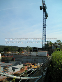 Eltham District Historical Society Inc
Photograph, Fay Bridge, The Canopy appartments under construction, Pryor Street, Eltham, 10 March 2019
First time a crane has ever been used for appartment construction in Eltham. The crane was illuminated at night and at times parked overhanging the roadfay bridge collection, 2019-03-10, eltham, eltham activity centre, pryor street, safeway supermarket, the canopy, woolworths -
 Eltham District Historical Society Inc
Photograph, Jim Connor, Main Road, Eltham, 10 Nov 2007
Former Methodiist Church now Eltham Uniting Church, cnr Main Road and John Street, ElthamTomorrow's history documented todayeltham, jim connor collection, main road, methodist church, uniting church -
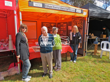
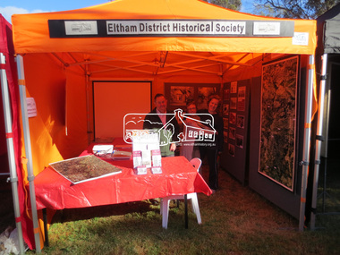 Eltham District Historical Society Inc
Photograph, Jim Connor, Eltham District Historical Society display, Eltham Festival, Alistair Knox Park, 10 Nov 2013
Eltham District Historical Society display, Eltham Festival, Alistair Knox ParkTomorrow's history documented todayeltham, jim connor collection, alison delaney, eltham district historical society, eltham festival, main road, russell yeoman, sue law -
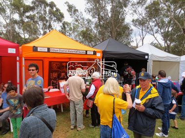
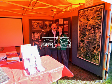 Eltham District Historical Society Inc
Photograph, Jim Connor, Eltham District Historical Society display, Eltham Festival, Alistair Knox Park, 10 Nov 2013
Eltham District Historical Society display, Eltham Festival, Alistair Knox ParkTomorrow's history documented todayeltham, jim connor collection, eltham district historical society, eltham festival, main road, russell yeoman, mary regan -
 Eltham District Historical Society Inc
Photograph, Jim Connor, Eltham District Historical Society display, Eltham Festival, Alistair Knox Park, 10 Nov 2013
Eltham District Historical Society display, Eltham Festival, Alistair Knox ParkTomorrow's history documented todayeltham, jim connor collection, eltham district historical society, eltham festival, main road, cheryl firth, doug orford, liz pidgeon, mary regan -
 Eltham District Historical Society Inc
Photograph, Jim Connor, Eltham District Historical Society display, Eltham Festival, Alistair Knox Park, 10 Nov 2013
Eltham District Historical Society display, Eltham Festival, Alistair Knox ParkTomorrow's history documented todayeltham, jim connor collection, eltham district historical society, eltham festival, main road, marion yeoman, russell yeoman -
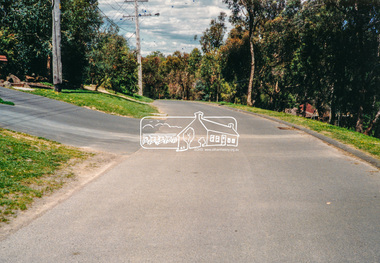 Eltham District Historical Society Inc
Photograph, Sackville Street, Montmorency, 15/10/1990
Sackville Street, Montmorency, 15 October 1990Colour photographinfrastructure, shire of eltham, montmorency, sackville street, quinn estate, roads -
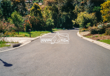 Eltham District Historical Society Inc
Photograph - Colour Print, Scarlet Ash Court, Eltham, 15 October 1990, 15/10/1990
Colour photo print eltham, infrastructure, roadworks - gutters, scarlet ash court, shire of eltham, stokes orchard estate, streets -
 Eltham District Historical Society Inc
Photograph, Hume and Hovell passed here at Seymour 28 Oct 1824, Spring Excursion, Hume and Hovell's 1824 expedition (Part 2), 26 October 1997, 26/10/1997
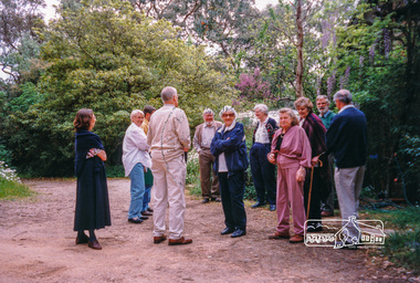
[article by Diana Bassett-Smith in EDHS Newsletter No. 117, November 1997:] MONUMENT HUNTING THE HUME AND HOVELL WAY - Sunday October 26 1997 dawned bright and very warm. Some twenty-five members, complete with picnic baskets, met outside the Eltham Library awaiting the Cobb and Co. large coach which would be taking us on the second leg of our travels along the route of the early explorers Hume and Hovell. Stephen West was our very good driver for the day. He would be guided around the circuitous route by Russell Yeoman who had made a detailed study, not only of the intended route, but of the story of these two explorers. During the trip Russell regaled us with poetry, quotations from the Journals and the History of the Shire of Seymour, "The New Crossing Place" by Martindale, 1982, (now Mitchell Shire due to the recent amalgamations). We headed towards the Hume Highway via Greensborough and Cooper Street and proceeded north to our first stop, noting on the way Monument Hill in the distance which is near Kilmore and, according to Russell, well worth the effort to visit as the view across the valley is magnificent. Past Sunday Creek Valley, Mt Piper and Mt Disappointment, all traversed and noted and named by them. We passed through Tallarook, then onto Seymour where we took photos of the monument telling us that Hume and Hovell had passed through on the 28th of October 1824. We also deviated down Hume and Hovell Road viewing deer and emu farming and the Bellbourie property now a sanctuary. Leaving Seymour behind we travelled up the Avenel Road to the Avenel monument, pyramidal in design of four reducing square blocks with a sharply pointed peak, erected in 1924 in memory of the 1824 exploration. The day was warming up and the countryside showing the dryness of the current drought. A parallel note had been made in their journal too of 1824 of the drought appearance of the country they were traversing. At Seven Creeks, Euroa we stopped for some minutes to check the monument placed 20th November 1924 to commemorate their passage on the 29th December 1824. More photos. Russell had pointed out the abrupt termination of the distant ranges which is noted in their journal. The next monument is beside the road at the entrance to Honey Suckle Creek Caravan Park, Violet Town. The squarish shaped monument some eight feet high is topped with a simple steel cross, and was to mark the date of 28th December 1824 and built for the 20th November 1924. By now it was 12.20 and nearly lunchtime as we drove along the Warranbayne Road to Roach's Road, monument hunting without success. Though there is a large, what appears to be an old timber sign which was hard to read, maybe this was the lost monument. In many of the paddocks hay had been cut and baled or was being cut, what a contrast to the rugged country they had passed through which was smoky from the fires of the natives burning off. By 1.00 pm we were at Benalla and pulled up beside the park where abundant beds of roses filled the air with their scent and the smell of barbecued food twitched the nostrils whilst the cheerful sounds of other picnickers could be heard throughout the park. We left the bus and collected up our picnics, dispersed to the various tables and enjoyed the shade from the various European trees. 2.00 pm and we were on the road again driving along the Benalla, Mansfield, Yea road. The Swanpool monument states that they passed four miles south and returned three miles north. Then we stopped at the Barjarg monument which notes that they camped near this spot. It is again a pyramidal monument and this time topped with a steel arrow indicating their route of the 29th November 1824. Half an hour later we came to another monument, again with a steel arrow marker on top and the plaque dated the 2nd of 12th 1824. Erected on the 12th of 12th 1924. "They blazed the way that we might inherit the land." Another square based and needle topped monument appeared at Yarck near Yea and this plaque records the date of 3 December 1824. Near McGuigans Road Russell related that the expedition had lost a dog but it had found them next day, the dog was apparently torn by a kangaroo. A short while later Russell reminded us here of the problems they encountered in crossing the Goulburn River near Molesworth where banks were high, water deep and wide. "Good coat of grass but quite dry due to drought". At Yea we stopped for afternoon tea and raided the last of our picnics and looked at the monument to their journey of 1824, situated at a corner of the gardens near the bowling green. No photo – we were out of film. We returned home via Kinglake West and Whittlesea past the Yan Yean Reservoir, not full. 5.00 pm back at Eltham we emptied out of the bus and everyone, including Joan Cole, collected their things, Joan also had the major souvenir of the day, a large carp she had picked up from the river bank, her cat was in for a great feast. The day was made so interesting by the informed commentary which Russell provided. His background knowledge of the route and nature of the journey could only have come from many hours of reading and driving the area. Thank you to Russell and to everyone who made the day so informative and pleasurable. Colour photographactivities, hume and hovell, monument, seymour -
 Eltham District Historical Society Inc
Photograph, Spring Excursion, Hume and Hovell's 1824 expedition (Part 2), 26 October 1997, 26/10/1997
[article by Diana Bassett-Smith in EDHS Newsletter No. 117, November 1997:] MONUMENT HUNTING THE HUME AND HOVELL WAY - Sunday October 26 1997 dawned bright and very warm. Some twenty-five members, complete with picnic baskets, met outside the Eltham Library awaiting the Cobb and Co. large coach which would be taking us on the second leg of our travels along the route of the early explorers Hume and Hovell. Stephen West was our very good driver for the day. He would be guided around the circuitous route by Russell Yeoman who had made a detailed study, not only of the intended route, but of the story of these two explorers. During the trip Russell regaled us with poetry, quotations from the Journals and the History of the Shire of Seymour, "The New Crossing Place" by Martindale, 1982, (now Mitchell Shire due to the recent amalgamations). We headed towards the Hume Highway via Greensborough and Cooper Street and proceeded north to our first stop, noting on the way Monument Hill in the distance which is near Kilmore and, according to Russell, well worth the effort to visit as the view across the valley is magnificent. Past Sunday Creek Valley, Mt Piper and Mt Disappointment, all traversed and noted and named by them. We passed through Tallarook, then onto Seymour where we took photos of the monument telling us that Hume and Hovell had passed through on the 28th of October 1824. We also deviated down Hume and Hovell Road viewing deer and emu farming and the Bellbourie property now a sanctuary. Leaving Seymour behind we travelled up the Avenel Road to the Avenel monument, pyramidal in design of four reducing square blocks with a sharply pointed peak, erected in 1924 in memory of the 1824 exploration. The day was warming up and the countryside showing the dryness of the current drought. A parallel note had been made in their journal too of 1824 of the drought appearance of the country they were traversing. At Seven Creeks, Euroa we stopped for some minutes to check the monument placed 20th November 1924 to commemorate their passage on the 29th December 1824. More photos. Russell had pointed out the abrupt termination of the distant ranges which is noted in their journal. The next monument is beside the road at the entrance to Honey Suckle Creek Caravan Park, Violet Town. The squarish shaped monument some eight feet high is topped with a simple steel cross, and was to mark the date of 28th December 1824 and built for the 20th November 1924. By now it was 12.20 and nearly lunchtime as we drove along the Warranbayne Road to Roach's Road, monument hunting without success. Though there is a large, what appears to be an old timber sign which was hard to read, maybe this was the lost monument. In many of the paddocks hay had been cut and baled or was being cut, what a contrast to the rugged country they had passed through which was smoky from the fires of the natives burning off. By 1.00 pm we were at Benalla and pulled up beside the park where abundant beds of roses filled the air with their scent and the smell of barbecued food twitched the nostrils whilst the cheerful sounds of other picnickers could be heard throughout the park. We left the bus and collected up our picnics, dispersed to the various tables and enjoyed the shade from the various European trees. 2.00 pm and we were on the road again driving along the Benalla, Mansfield, Yea road. The Swanpool monument states that they passed four miles south and returned three miles north. Then we stopped at the Barjarg monument which notes that they camped near this spot. It is again a pyramidal monument and this time topped with a steel arrow indicating their route of the 29th November 1824. Half an hour later we came to another monument, again with a steel arrow marker on top and the plaque dated the 2nd of 12th 1824. Erected on the 12th of 12th 1924. "They blazed the way that we might inherit the land." Another square based and needle topped monument appeared at Yarck near Yea and this plaque records the date of 3 December 1824. Near McGuigans Road Russell related that the expedition had lost a dog but it had found them next day, the dog was apparently torn by a kangaroo. A short while later Russell reminded us here of the problems they encountered in crossing the Goulburn River near Molesworth where banks were high, water deep and wide. "Good coat of grass but quite dry due to drought". At Yea we stopped for afternoon tea and raided the last of our picnics and looked at the monument to their journey of 1824, situated at a corner of the gardens near the bowling green. No photo – we were out of film. We returned home via Kinglake West and Whittlesea past the Yan Yean Reservoir, not full. 5.00 pm back at Eltham we emptied out of the bus and everyone, including Joan Cole, collected their things, Joan also had the major souvenir of the day, a large carp she had picked up from the river bank, her cat was in for a great feast. The day was made so interesting by the informed commentary which Russell provided. His background knowledge of the route and nature of the journey could only have come from many hours of reading and driving the area. Thank you to Russell and to everyone who made the day so informative and pleasurable. Colour photographactivities, hume and hovell, bridge -
 Eltham District Historical Society Inc
Photograph, Peter Bassett-Smith, Eltham Mud Brick Heritage Excursion, 4 October 1998, 04/10/1998
[article in EDHS Newsletter No. 123, November 1998:] MUD BRICK HERITAGE EXCURSION AND THE FUTURE. A small group of members attended the excursion on 4th October. We visited a number of earth houses listed by the Eltham Heritage Study in a very pleasant day's outing. The first visit was to the home of Jenny and Brian Ellis in York Street, formerly the home of Jenny's father Professor William McMahon Ball. We were made very welcome with inspection of the inside and outside showing the various stages of construction. We then walked through the grounds of "Kinloch", the Jelbart property in Arthur Street where we saw their large mud brick house and barn. Lunch was at Marion and Russell Yeoman's house in Peter Street. This pise house was built by the Moore family in the early 1950's. In the afternoon we visited the home of artist Jenni Mitchell in Fordhams Road, one of the last examples of the work of Alistair Knox. Then we travelled to Laughing Waters Road where we saw two interesting houses owned and built by well known landscape gardener Gordon Ford. Along the way we stopped to view a number of other properties from the street.Colour photographactivities, eltham, heritage excursion, mud brick