Showing 2286 items matching " parish."
-
 Linton and District Historical Society Inc
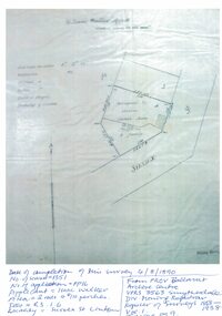
Mining survey document, Mining Survey Document, 1890
Document drawn up in relation to an application for a mining lease made by Isaac Walker of Linton. Application no. PP16, Lease no. 1351. Application was made for a mining lease on land in Sussex Street, Linton, which was occupied by Sarah Dawe and family. Original document is held at PROV Ballarat. Item and series details are recorded in handwriting on the lower part of the document.Photocopy of original document, which shows a plan of Allotments 3 & 4, Section 1A, Township of Linton, Parish of Argyle.mining applications, mining leases, plans, documents, isaac walker, dawe family, sarah dawe née carpenter -
 Linton and District Historical Society Inc
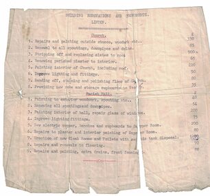
Building quote, Church of England Building Renovations and Improvements, Linton
Typed, undated quote for costs of building renovations and improvements to Linton Church of England and parish hall. Builder's name not recorded.Text: " BUILDING RENOVATIONS AND IMPROVEMENTS / LINTON. "st paul's church of england linton, parish hall -
 Bendigo Historical Society Inc.
Map - CAMPBELL COLLECTION: BENDIGO AND DISTRICT MAPS, 8-6 29
Map. Kimbolton, Parishes of Kimbolton and Lyell, scale 20 chains to 1 inch. Area by Plamimeter 6258 acres. Coliban River, Knowsley, Strathfieldsaye 10 1/2 miles. Prepared in W.P.B. from Parish and Assessor's Plans. G.W.Latimer 8-6-29. (number 393 in map cupboard 1)G.W.Latimermap, bendigo, allotments -
 Bayside Gallery - Bayside City Council Art & Heritage Collection
Map, Department of Crown Lands and Survey, Moorabbin, County of Bourke, c. 1918
The cadastral map of the Parish of Moorabbin in Victoria (L.6104) shows parish boundaries and land ownership c. 1918 when Sandringham was a Borough.moorabbin, county of bourke, map, plan, land subdivision, land titles, foreshores, sndringham, hampton, beaumaris, highett, cheltenham, department of lands and survey, land owners, cartographic material, borough of sandringham, brighton -
 Ringwood and District Historical Society
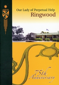
Book, "Our Lady of Perpetual Help Ringwood" History Book, 2005
Book produced for the 75th anniversary of the Parish and school. List of Principals, list of Parish Priests. The school was built in 1932 on what had been an orchard.Yellow and black covered book with photos of church on front and schoolchildren on back. 46 pages of text and photos, no index. +Additional Keywords: Lacey, Angela / Tien, Joe Bui DucCelebrating 75 years of history at Our Lady of Perpetual Help School in Wilana Street, Ringwood -
Bendigo Historical Society Inc.
Map - CAMPBELL COLLECTION: BENDIGO AND DISTRICT MAPS
Map. Sedgwick. Parishes of Strathfieldsaye, Lyell and Sedgwick. Scale 20 chains to 1 inch. (number 359 in map cupboard 1)map, bendigo, agricultural lands -
Bendigo Historical Society Inc.
Map - CAMPBELL COLLECTION: BENDIGO AND DISTRICT MAPS
Map. Lyell, Parishes of Sedgwick, Eppalock and Lyell. Scale 20 chains to 1 inch. (number 348 in map cupboard 1)map, bendigo, agricultural lands -
Port Melbourne Historical & Preservation Society
Booklet - Carmelite Parish newsletter, "The Carmelite" 7 October 2018, 2018 - 2019
These items were collected by a PMHPS member during 2018-19 and they have been retained as a group of ephemeraVarious ephemera of local interest showing changes in community. .01 The Carmelite Parish newsletter booklet dated 7 October 2018religion - roman catholic church (st josephs), parish of port melbourne -
Bendigo Historical Society Inc.
Map - PART PARISHES OF MANDURANG AND SANDHURST, No date visible
Map: Section of Parish plan of Bendigo covering Mandurang, Diamond Hill, and Quarry Hill, ( number 147 in Map Cupboard 1).Map 11map, bendigo, city streets, parish of mandurang, parish of sandhurst, diamond hill , quarry hill -
Bendigo Historical Society Inc.
Map - MANDURANG, November 6th 1854
Map: The village of Mandurang situated about 6 miles from Sandhurst, Parish of Mandurang ( number 155 in Map Cupboard 1)map, bendigo, village, mandurang -
Bendigo Historical Society Inc.
Map - BENDIGO SHEET 3
Map: copy of Parish plan, canvas backed. Map shows Bendigo city streets. ( number 126 in Map Cupboard 1)map, bendigo, city streets, bendigo, city streets -
Bendigo Historical Society Inc.
Map - SANDHURST (PART), Circa 1880's
Map: Parish plan showing an area from McKenzie/View streets to Long Gully ( number 232 in Map Cupboard 1)map, bendigo, parish plan, sandhusrt, mckenzie street , view street, long gully -
Bendigo Historical Society Inc.
Map - LOCKWOOD, November 25th 1855
Map: Garden Allotments within the Town Reserve of Lockwood on the Bullock Creek. Parish plan (number 273 in map cupboard 1)map, bendigo, parish plan, lockwood, garden allotments, bullock creek -
Whitehorse Historical Society Inc.
Article, Unit meeds need, 1993
An urgently needed oxygen unit has been donated to the Mid-Eastern Palliative Care Association by St John's Parish, MitchamAn urgently needed oxygen unit has been donated to the Mid-Eastern Palliative Care Association by St John's Parish, MitchamAn urgently needed oxygen unit has been donated to the Mid-Eastern Palliative Care Association by St John's Parish, Mitchamhealth services, mid-eastern palliative care association, parker, mary, bergman, doug, dillon, kevin joseph, fr. -
Whitehorse Historical Society Inc.
Legal record - Land Title, Blackburn
Plan of subdivision of part of Crown Portions 81,92 and 89, Parish of Nunawading, County of Bourke. Photograph produced 11 Aug 1947.Plan of subdivision of part of Crown Portions 81,92 and 89, Parish of Nunawading, County of Bourke. Photograph produced 11 Aug 1947.Plan of subdivision of part of Crown Portions 81,92 and 89, Parish of Nunawading, County of Bourke. Photograph produced 11 Aug 1947.blackburn road, blackburn, wellington avenue, central road, gordon crescent, wolseley crescent -
Whitehorse Historical Society Inc.
Newspaper - Article, Bishop celebrates 50 years service, 1/08/1990
Article by Wendy Woods on Bishop Eric Perkins, parish priest of St Thomas the Apostle, Blackburn, celebrating 50 years as a priest.perkins, eric bp., st thomas the apostle catholic church, blackburn -
 Whitehorse Historical Society Inc.
Photograph, War Memorial
Black & white velox print of a woman in a dark dress standing next to a tombstone at the Parish cemetery at Werhrmont. Copy 1 & 2war memorial wehrmont -
 Ballarat Diocesan Historical Commission
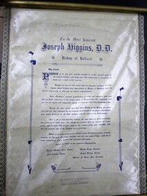
Address on silk scroll, Address of welcome
Address of Welcome to Bishop Higgins of Ballarat on his first official visit to the Clunes parish which then included Talbot, Smeaton and Lexton.An old stamp to bottom of scroll showing formerly held in the Melbourne Diocesan Historical collection.talbot, clunes, smeaton, lexton, higgins, ballarat silk scroll, address of welcome. -
Canterbury History Group
Book, R. J. Macdougall, History of St. John's Camberwell, 1963
A detailed historical account of the Parish of St. John's Anglican Church, Camberwell. Includes biographies of vicars and several black and white photographs.non-fiction churches, clergy, camberwell, st john's church, centenary -
Lakes Entrance Historical Society
Book, Rice Isobel and Jensen Mary, Who Shall find a Valiant Woman, 1986
A history of the establishment and growth of the Catholic women's League in the Diocese of Sale, covering many parishes, listed alphanumerically from Bairnsdale to Yinnar.religion -
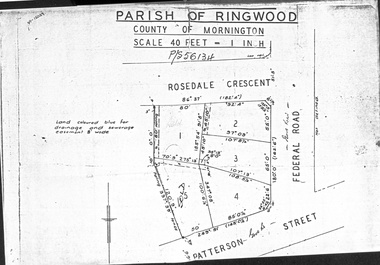 Ringwood and District Historical Society
Document - Folder, Map of Subdivision for auction - Ringwood East, Vic., 1973
Photocopy of Parish Map showing five residential blocks for sale on Rosedale Crescent, Federal Road and Patterson Street Ringwood East.Accompanying handwritten sales notes researched in 2024 by Richard Carter - Carter Real Estate - "5 lots (heavily filled) auction 14 July 1973. All later sold $4000 each - unknown agent". -
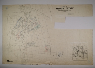 Bendigo Historical Society Inc.
Map - MEMSIE ESTATE, 26/08/1905
Map:Plan of Memsie estate, aquired under Closer Settlement Act 1904. Parish plan. Map dated 26/08/1905.map, estate, memsie estate, closer settlement act 1904. -
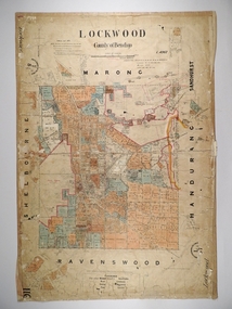 Bendigo Historical Society Inc.
Map - LOCKWOOD, 13/03/1876
Map: Lockwood, County of Bendigo. Parish plan. Compiled Jan. 1876. W. P. Lake Draftsman. paper on canvas backing.map, bendigo, parish plan, lockwood, w. p. blake -
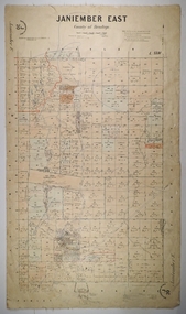 Bendigo Historical Society Inc.
Map - JANIEMBER EAST, 26/07/1879
Map: Janiember East, County of Bendigo. Parish plan Examined by T Pures 16.10.75 S M Reed August 1875map, bendigo, parish plan, janiember east, serpentine -
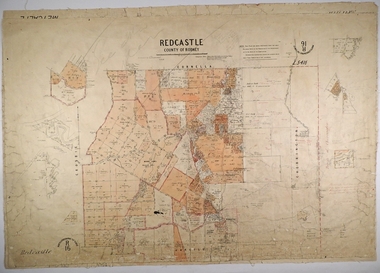 Bendigo Historical Society Inc.
Map - REDCASTLE, 15/10/1878
Map: Redcastle, County of Rodney. Parish plan. Examined E. D. Downward 28.9.78 T, S Hall Aug 78map, rodney, parish plan, redcastle, t. s. hall, e. d. downward -
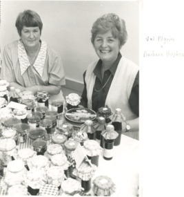 Lakes Entrance Historical Society
Photograph - Bruthen Parish Fair, Bruthen Victoria
Black and white photograph of Val Pilgrim and Barbara Hughes at Berry Farell stall Bruthen Parish Fair Art and Craft weekendevents, social history, religion -
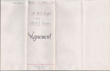 Bendigo Historical Society Inc.
Legal record - BOGLE Gilbert Innes - Land Lease, Watson, James & Rogers, Rogers Collection, 1911
In the early 1980s the firm of Watson, James & Rogers merged with the partnership of Every & Every and became the iconic “Rogers & Every” as known today. The firm is still located on Bull Street. https://rogersevery.com.au/about/Agreement between Gilbert Bogle and Archibald James Fraser concerning the lease of land in the Parish of Mandurang. Dated 5 April 1911.Signatureswatson james & rogers, bendigo, legal documents, mandurang, fraser -
 Bendigo Historical Society Inc.
Legal record - FEATONBY Mrs Anne - Sale Note, Watson, James & Rogers, Rogers Collection, 10.02.1920
In the early 1980s the firm of Watson, James & Rogers merged with the partnership of Every & Every and became the iconic “Rogers & Every” as known today. The firm is still located on Bull Street. https://rogersevery.com.au/about/FEATONBY, Mrs Anne Sale note re Crown Allotment 4, Parish of Warriwitue County of Dalhousie. Cream coloured paper.Signatures.sale note, sherriff, featonby, public auction, land sale, nicholas kennedy -
Glen Eira Historical Society
Drawing - St. Agnes Church, Booran Road, 116, Glen Huntly
A 105 Committee pamphlet giving thumbnail sketch of parish and the reasons why the 105 committee was formed for the church repair program and renovation for the growing parish community.st. agnes’ church, glen huntly, booran road, wright nigel father, barren john, britton cath, cheshire jean, jennings phil, lusk gary, tomlinson mac, agg val, clarke wilf, young george, architectural features, stanistreet john, timber, foundation stores -
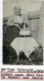 Ararat & District Historical Society (operating the Langi Morgala Museum)
Photograph
Mrs Traynor's 80th birthdayBlack and white photograph of an elderly woman wearing a light coloured button up shirt and long dark skirt. She is standing behind a table covered in a white cloth and is cutting a birthday cake with candles. The photo is mounted on white cardboard.Written under the photo: Mrs Tom Traynor nee Parish husband owned black kiln on property near Prestige.