Showing 2475 items matching " township"
-
 Lakes Entrance Historical Society
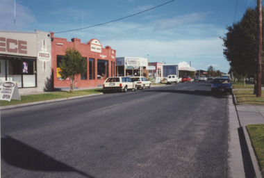
Photograph - Church Street Lakes Entrance Victoria 1999, M Holding, 1999
Colour photograph showing businesses on south side of Church Street from Reece Plumbing to Retrovision on corner of Church and Carpenter Streets Lakes Entrance Victoria c1999businesses, township, roads and streets -
 Lakes Entrance Historical Society
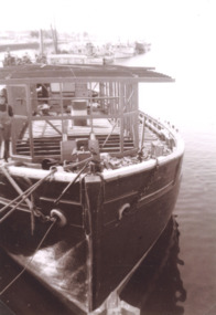
Photograph, Peel family, Peels launch Lenna Bird, Lakes Entrance Victoria, 1966
Black and white photograph of former Tasmanian ketch Lenna during conversion to Peels launch Lenna Bird moored in Cunninghame Arm Lakes Entrance Victoria. Also a second photograph of Lenna on slips prior to final refitting as Peels launch Lenna Bird tourism, boats and boating, township -
 Lakes Entrance Historical Society
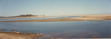
Photograph - Lake Tyers Beach, 2000
Colour photograph of Lake Tyers Beach from car park Lake Tyers Victoria. Also a second colour photograph of Lake Tyers Beach taken from a different angle township, beaches, gippsland lakes -
 Lakes Entrance Historical Society
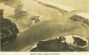
Postcard - Aerial view Lakes Entrance, H D Bulmer, 1922 c
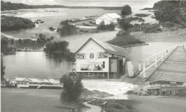
Image clearly shows new alignment of Princes Highway around Jemmys Point and part of the original high road to the first bend above North Arm BridgeBlack and white postcard aerial view of the western area of the town, Bullock Island and Snake Island and waterways Lakes Entrance VictoriaAerial View Lakes Entrancewaterways, islands, township -
 Lakes Entrance Historical Society
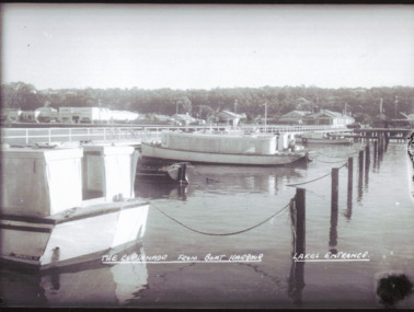
Postcard - Esplanade Lakes Entrance Victoria from Boat Harbour, Bulmer
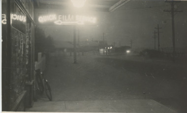
Also a black and white photograph of Entrance with sailing vessel beside Western Pier 05256.1 12.5 x 17 cmBlack and white photograph of Esplanade from boat harbour showing Loch Ard with the Blackbird behind it. Kents Garage far left with Venga guesthouse and Robinhood Inn to the right Lakes Entrance VictoriaThe Esplanade from Boat Harbour Lakes Entrancetownship, boats and boating, businesses -
 Lakes Entrance Historical Society
Album - Photographs of Lakes Entrance, Lorna Mitchelson, 1992 c
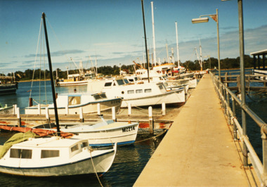
Photograph album produced by Lorna Mitchelson and donated by her son Jim.Photograph album containing colour prints taken of boats on the North Arm and Cunninghame Arm and some of the businesses on Esplanade Lakes Entrance Victoriawaterways, businesses, township -
 Lakes Entrance Historical Society
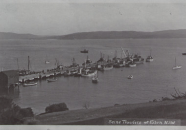
Postcard, Siene Trawlers Eden, 1945 c
Also a black and white postcard Ashling Beach Eden N.S W. 05410.1 7 x 8 cmBlack and white copy of postcard showing seine trawlers and other boats at long wharf Eden New South WalesSeine Trawlers at Eden N.S.W.ships and shipping, waterways, township -
 Lakes Entrance Historical Society
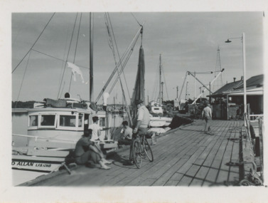
Photograph, Eastern Wharf Lakes Entrance, 1955 c
Also 13 black and white photographs of fishing boats at jetties Lakes Entrance 05409.1,.2, .3, .4,.5, .6, .7,.8,.9,.10,.11,.12, .13Black and white photograph x13 of fishing boats moored at Eastern Wharf aka Harbecks Jetty five men on wharf one with bicycle Lakes Entrance Victoriawaterways, township, ships and shipping -
 Lakes Entrance Historical Society
Postcard, H D Bulmer, Bulmer's/Black Friday, 1/01/1939 12:00:00 AM
Black and white postcard of Bulmers shop taken during the Black Friday bushfires showing businesses almost hidden in dense smoke from nearby fires Esplanade Lakes Entrance Victoriabusinesses, township, bushfires -
 Lakes Entrance Historical Society
Postcard - Marlo Victoria, Photo images Australia, Views of Marlo, 2010
Black and white postcard collage of images taken around Marlo Victoria waterways, township, rivers -
 Lakes Entrance Historical Society
Postcard, Bulmer, Scene from Jemmys Point, 1900 c
Black and white postcard showing view from Jemmys Point of east end of Rigby Island and Reeves channel the entrance and sand dunes with Hope channel in distance Lakes Entrance Victoria.Also another copy of same postcard township, waterways, islands -
 Lakes Entrance Historical Society
Postcard, Lakes Entrance 1930, 1930 c
Black and white postcard showing view from top of hill north of Lakes Entrance shows North Arm with west end of town Cunninghame Arm and sand dunes in distance. Track in foreground Myers Street known as Allens Hill in 1930 Lakes Entrance Victoriatownship, waterways, roads and streets -
 Lakes Entrance Historical Society
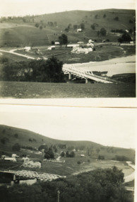
Photograph - Buchan Victoria, Myrtle Olive Fish, 1/09/1933 12:00:00 AM
Black and white photographs of view of Buchan with bridge over Buchan River in foreground with butter factory behind and various buildings Buchan Victoriatopography, township, waterways -
 Lakes Entrance Historical Society
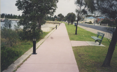
Photograph - The Esplanade Lakes Entrance, Lakes Entrance Tidy Town Committee, 1994 c
Colour photograph of the Western section of the pathway beside Cunninghame Arm looking towards Club Jetty and Club Spit, low lights beside path, seat on lawn area beside road Lakes Entrance Victoria Looking toward Number 1 the Esplanade.Also a colour photograph taken of path beside Cunninghame Arm, cars parked and person walking on path information, tourism, township -
 Lakes Entrance Historical Society
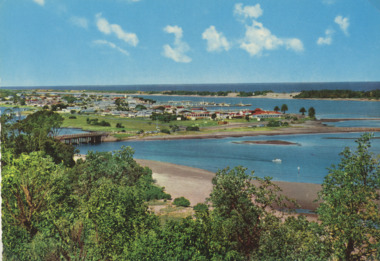
Postcard - Views of Lakes Entrance c1970, John Engelander and Co Melbourne, 1970 c
Princes Highway to town showing concrete bridge over North Arm . Also identical postcard with message on back in Spares boxColour postcard of view from Princes Highway to town showing concrete bridge over North Arm old toilet block opposite road to Bullock Island, Club Spit being formed, Hill 60 visible on outer barrier hummocks Lakes Entrance Victoriaroads and streets, township, waterways -
 Lakes Entrance Historical Society
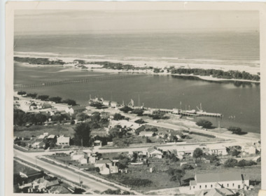
Photograph - Lakes Entrance, Brian Lloyd, c1954
Aerial view of Lakes Entrance c1954. Plus 2 other aerial views in albumBlack and white photograph of a section of the town taking in St Brendans church, Bulmer Street from Esplanade to Church Street, some of the waterfront, the footbridge and hummocks Lakes Entrance Victoriaaerial photograph, township, beaches -
 Lakes Entrance Historical Society
Photograph - Frenchman's Gully/Taradale, 2000 c
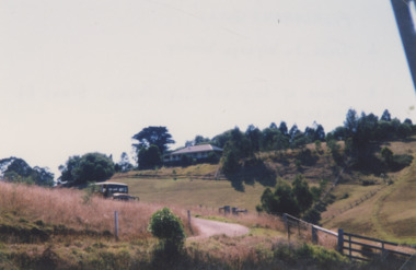
Also a similar colour photograph number 03861.1 size 10 x 15 cmColour photograph of Frenchman's Gully showing Wyanga Winery vehicle on winery track with property Taradale of Leigh and Judy Davies on opposite hill Lakes Entrance Victoriaaerial photograph, topography, township -
 Kiewa Valley Historical Society
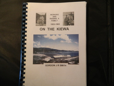
Book - On the Kiewa, Working & Raising a Family 1953 - 1963 by Gordon J. R. Smith, 9th September 2005
Personal account of Gordon Smith's life when living in Mt Beauty and Bogong townships while working for the SECV on the Kiewa Hydro Electric Scheme.Gordon gives an account of both working and living during the 1950s and early 1960s in a remote part of Victoria - the Kiewa Valley and in 2 small construction towns. He gives a lot of detail eg. the weather, his work, the people, the activities, his family and leisure time.Plastic threaded spine holding 282 pages with black and white photos. Front Cover includes 2 small black and white photos either side of the title at the top and below the title a larger colored photo of Rocky Valley Dam. Author's name is underneath. "Dick Puttyfoot" on cover page.kiewa hydro electric scheme, state electricity commission of victoria., gordon smith -
 Marysville & District Historical Society
Photograph (Item) - Colour photograph, Unknown
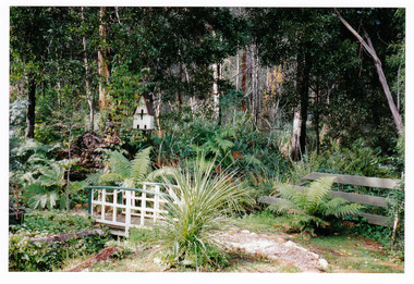
A colour photograph of the rear gardens at Arbor Green Galleries in Marysville. This cottage, along with most of the buildings in the township, was destroyed in the 2009 Black Saturday bushfires.A colour photograph of the rear gardens at Arbor Green Galleries in Marysville.Arbor Green Gardens/ 1 Falls Rd M'sville./ Rear gardenmarysville, victoria, australia, photograph, accommodation, arbor green cottage, 2009 black saturday bushfires -
 Marysville & District Historical Society
Photograph (Item) - Colour photograph, Unknown
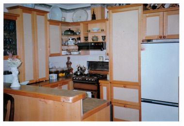
A colour photograph of the kitchen in the cottage at Arbor Green Galleries and Cottage. This cottage, along with most of the buildings in the township, was destroyed in the 2009 Black Saturday bushfires.A colour photograph of the kitchen in the cottage at Arbor Green Galleries and Cottage.1 Falls Rd. M'sville./ Cottage Kitchen.marysville, victoria, australia, photograph, accommodation, arbor green cottage, 2009 black saturday bushfires -
 Marysville & District Historical Society
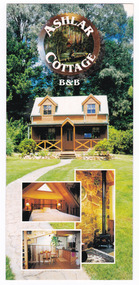
Flyer (Item) - Information flyer, Wayne Louk, ASHLAR COTTAGE B&B, Unknown
An information flyer regarding Ashlar Cottage B&B in Marysville. This cottage, along with the majority of the buildings in the township, was destroyed in the 2009 Black Saturday bushfires.An information flyer regarding Ashlar Cottage B&B in Marysville.marysville, victoria, australia, information flyer, accommodation, ashlar cottage b&b, 2009 black saturday bushfires -
 Phillip Island and District Historical Society Inc.
Newspaper clippings, The Age Newspaper, 1888
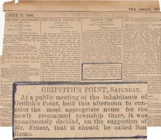
News item showing report of Public meeting to name township growing at Griffiths Point. Suggested by Mr Fraser that it be named San Remo. 1888Newspaper cutting with highlighted item "Griffiths Point Saturday" taken from The Age.July 9, 1888. No. 421local history, documents, newspapers, griffiths point, san remo, local area development, black & white newspaper clipping, newspapers san remo -
 Kiewa Valley Historical Society
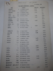
Papers - Mt Beauty Householders 1964, Mt Beauty Householders - Directory
Mt Beauty township was built in the late 1940s by the State Electricity Commission of Victoria for its workforce during the construction of the Kiewa Hydro Electric Scheme.This is a list of the early occupants of Mt Beauty township, naming the head of the household. It lists their phone numbers but not their occupations or family members.16 pages of Foolscap paper held by 2 staples in the top right hand corner. It consists of the following headings: - Name, Address, Phone No., and Sect-Allot.. The names are in alphabetical order. Commission owned houses are asterisked. All lists are as at 1st October, 1964Written in pen on top of first page "Patrol Supvr. - Info. Centre'mt beauty householders, mt beauty directory, mt beauty telephone directory, mt beauty residents 1964, mt beauty township -
 Marysville & District Historical Society
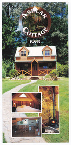
Flyer (Item) - Information flyer, Wayne Louk, ASHLAR COTTAGE B&B, Unknown
An information flyer regarding Ashlar Cottage B&B in Marysville. This cottage, along with the majority of the buildings in the township, was destroyed in the 2009 Black Saturday bushfires.An information flyer regarding Ashlar Cottage B&B in Marysville.marysville, victoria, australia, information flyer, accommodation, ashlar cottage b&b, 2009 black saturday bushfires -
 Donald History and Natural History Group operating the Donald Court House Museum
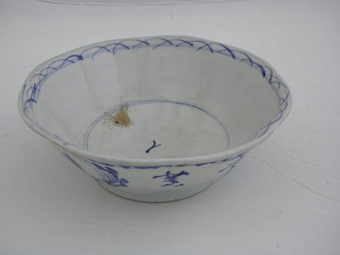
Bowl, Unknown Potter
Ceramic bowl found in hut belonging to Georgie Ah Ling, who operated a market garden for about 70 years on the edge of the township of Donald. Hand-molded blue and white ceramic bowl. Outside of bowl has underglaze blue decoration of flowers, leaves and Chinese characters. Saw toothed decoration, with one line underneath, around outside rim. Half moon shape lines, with two lines through them, decorate inside rim. Two lines around inside base with one Chinese character in centre of inside base.One Chinese character on inside base of bowl. Four Chinese characters and five plant symbols on outside of bowl. ceramic, bowl, hut, georgie ah ling, market garden, donald -
 Donald History and Natural History Group operating the Donald Court House Museum
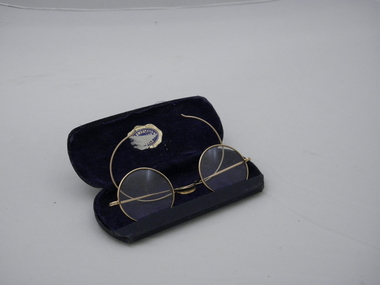
Spectacles and case
Reading spectacles found in hut belonging to Georgie Ah Ling, who operated a market garden for about 70 years on the edge of the township of Donald. Round glass, gold coloured wire framed spectacles in a hard covered case lined with dark blue material. Gold and dark blue suppliers sticker, partly torn, on inside lid of case.Sticker on inside of case partly torn, but probably reads "W. R. Swaby F.V.O.A. Jeweller Donald". reading spectacles, hut, georgie ah ling, market garden, donald -
 Bacchus Marsh & District Historical Society
Map, Gorrockburkchap Parish Map, County of Grant c.1906
The parish of Gorrockburkchap (sometimes spelled Gorrockburkghap) lies to the west and south west of the township of Bacchus Marsh. The locality of Rowsley is situated within this parish area.A single page paper map showing the parish plan for Gorrockburkchap in the County of Grant. A cadastral map showing parish boundaries and land ownership The map is pasted into a bound volume containing 76 maps or plans in total. High resolution digital image stored on BMDHS computer network. gorrockburkchap parish maps, rowsley victoria maps, bacchus marsh region parish plans -
 Bacchus Marsh & District Historical Society
Map, Gorrockburkchap Parish Map, County of Grant c.1915
The parish of Gorrockburkchap (sometimes spelled Gorrockburkghap) lies to the west and south west of the township of Bacchus Marsh. The locality of Rowsley is situated within this parish area.A single page paper map showing the parish plan for Gorrockburkchap in the County of Grant. The map is pasted into a bound volume containing 76 maps or plans in total. High resolution digital image stored on BMDHS computer network. gorrockburkchap parish maps, rowsley victoria maps -
 Bacchus Marsh & District Historical Society
Map, Gorrockburkchap Parish Map, County of Grant
The parish of Gorrockburkchap (sometimes spelled Gorrockburkghap) lies to the west and south west of the township of Bacchus Marsh. The locality of Rowsley is situated within this parish area.A single page paper map showing the parish plan for Gorrockburkchap in the County of Grant. The map is pasted into a bound volume containing 76 maps or plans in total. High resolution digital image stored on BMDHS computer network. gorrockburkchap parish maps, rowsley victoria maps -
 Glenelg Shire Council Cultural Collection
Souvenir - Souvenir Envelope, 1984
Two Australia Post souvenir envelopes - Victoria's 150th anniversary (Portland. First settlement). Cream coloured, envelope, full colour design on front of envelope shows Edward Henty, view of township, thistle, pier and council logos. Reverse has shows 150th.australia post, souvenir, victoria 150th