Showing 1132 items matching " waterways"
-
 Lakes Entrance Historical Society
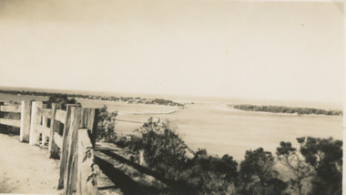
Photograph - The Entrance Lakes Entrance, 1925 c
... Waterways ...The entrance to Gippsland Lakes taken from Princes Highway, post and rail fence in foreground Lakes Entrance VictoriaBlack and white photograph of entrance taken from Princes Highway, post and rail fence in foreground Lakes Entrance Victoriaboats and boating, islands, waterways, gippsland lakes -
 Lakes Entrance Historical Society
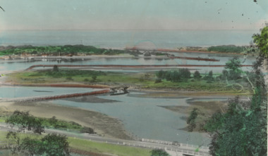
Postcard - Bullock Island Lakes Entrance, H D Bulmer, 1950 c
... Waterways ...Bullock Island and first traffic bridge. Bullock Island has no development. North Arm bridge and Princes Highway in foreground, New Works area across Cunninghame Arm in distance Lakes Entrance Victoria. Also a cut down colour photograph of second humpy bridge to Bullock Island donated by M Fish number 04208.1 size 3 x 13 cm|Also two black and white photographs numbers 04208.2 and 04208.3 in SparesColour tinted postcard of Bullock Island and first traffic bridge. Bullock Island has no development. North Arm bridge and Princes Highway in foreground, New Works area across Cunninghame Arm in distance Lakes Entrance Victoria. Also a cut down colour photograph of second humpy bridge to Bullock Island donated by M Fish number 04208.1 size 3 x 13 cm|Also two black and white photographs numbers 04208.2 and 04208.3 in Spares Bullock Island and Bridge Lakes Entrance waterways, gippsland lakes, islands, vegetation -
 Lakes Entrance Historical Society
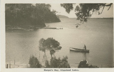
Postcard - Harpers Bay Gippsland Lakes, H D Bulmer, 1925 c
... Waterways ...Harpers Bay showing the jetty where tourist launches moored for passengers to land and walk up to Mrs Westersons Cliffcrest Tea Rooms, Jemmys Point in distance Gippsland Lakes VictoriaBlack and white postcard of Harpers Bay showing the jetty where tourist launches moored for passengers to land and walk up to Mrs Westersons Cliffcrest Tea Rooms, Jemmys Point in distance Gippsland Lakes VictoriaHarpers Bay Gippsland Lakesbridges, islands, waterways, gippsland lakes -
 Lakes Entrance Historical Society
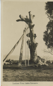
Postcard, H D Bulmer, Historic Lookout tree Jemmys Point Lakes Entrance, 1925 c
... Waterways ...Jemmys Point showing an old dead grey box tree trunk many limbs lying on ground near base trunk stabilized by two long poles straight ladder from ground to fork at top Lakes Entrance Victoria. This tree eventually fell down in 2024. East Gippsland shire have placed a garden bed around it.Black and white postcard of Lookout on Jemmys Point showing an old dead grey box tree trunk many limbs lying on ground near base trunk stabilized by two long poles straight ladder from ground to fork at top Lakes Entrance VictoriaLookout Tree Lakes Entrancejetties, waterways, jemmys point lakes entrance, topography -
 Lakes Entrance Historical Society
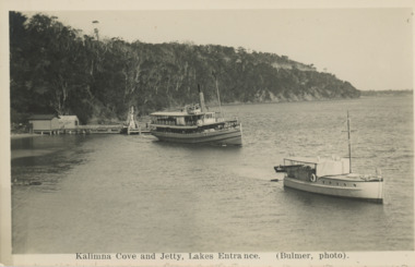
Postcard - S S Gippsland leaving Kalimna Jetty Lakes Entrance, H D Bulmer, 1930 c
... Waterways ...S S Gippsland leaving Kalimna Jetty Holdens boat Sagitasse moored nearby Jemmys Point in distance Lakes Entrance VictoriaBlack and white postcard showing S S Gippsland leaving Kalimna Jetty Holdens boat Sagitasse moored nearby Jemmys Point in distance Lakes Entrance VictoriaKalimna Cove and Jetty Lakes Entranceislands, waterways, boats and boating, tourism -
 Lakes Entrance Historical Society
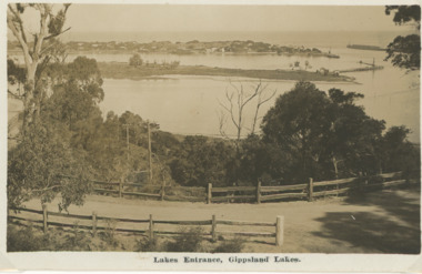
Postcard, H D Bulmer, Princes Highway Lakes Entrance Victoria, c1930
... Waterways ...Black and white postcard showing part of Princes Highway below Jemmys Point, undeveloped Bullock Island New Works area and Entrance in distance Lakes Entrance VictoriaLakes Entrance Gippsland Lakesroads and streets, transport, township, waterways -
 Lakes Entrance Historical Society
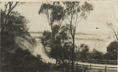
Postcard - Princes Highway around Jemmy's Point
... Waterways ...Princes Highway around Jemmy's Point . Unsealed road and post and rail fence. Bullock Island and the entrance in the distance c1925Black and white photograph of Princes Highway around Jemmy's Point . Unsealed road and post and rail fence. Bullock Island and the entrance in the distance waterways, topography, islands, roads and streets -
 Lakes Entrance Historical Society
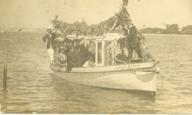
Postcard - Lalla Rookh Gippsland Lakes Victoria, 1925 c
... Waterways ...Black and white postcard showing a group of excursionists on tourist launch Lalla Rookh which is decorated with greenery and Australian flags. Person on bow about to throw mooring rope to jetty on Gippsland Lakes Victoriajetties, waterways, boats and boating, gippsland lakes -
 Lakes Entrance Historical Society
Photograph - Lakes Tide and dredge Sandpiper at Fishermans Coop Lakes Entrance Victoria 1989
... Waterways ...Colour photograph of wharf at Bullock Island showing oil rig supply vessel Lakes Tide and dredge Sandpiper at moorings Fishermans Coop building in background Thunderbird at New Works jetty in distance. Taken from dredge April Hamer Lakes Entrance Victoria 1989boats and boating, jetties, business, waterways -
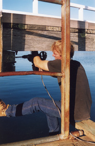
 Lakes Entrance Historical Society
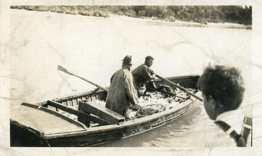
Photograph - Fishing Industry, fishing boat Lakes Entrance Victoria, 1940 c
... Waterways ...Black and white photograph of fishing boat half full of fish being rowed away from unseen jetty, head and shoulders of young boy on right of image. Lakes Entrance Victoriafishing industry, boats and boating, fish, waterways -
 Lakes Entrance Historical Society
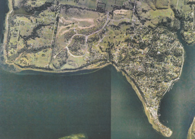
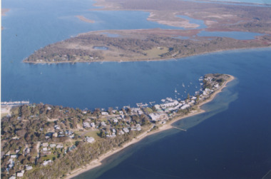
Photograph - Metung, Gippsland Ports, 2006 c
... Waterways ...Colour aerial photograph showing Shaving Point at Metung including Chinamans Creek at the right housing subdivisions of Kingscove Estate Tambo Bluff Estate and Lake King on Gippsland Lakes Victoriaaerial photograph, topography, waterways, metung -
 Lakes Entrance Historical Society
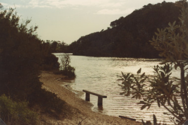
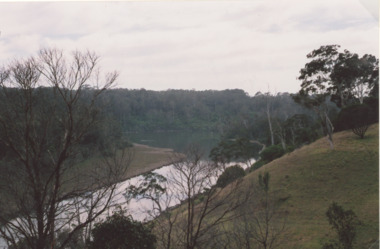
Photograph - Lake Bunga, Marie Fish, 1990c
... Waterways ...Colour photograph taken from Western shore looking upstream showing heavily timbered banks Lake Bunga Victoriabridges, forest, historic site, waterways -
 Lakes Entrance Historical Society
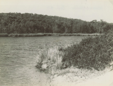
Photograph - Lake Bunga, 1947
... Waterways ...Also another black and white photograph number 03842.1 size 8 x 10.5 cm Black and white photograph showing Eastern shore with heavily timbered background taken from Western shore Lake Bunga Victorialake bunga, waterways, forest, vegetation -
 Lakes Entrance Historical Society
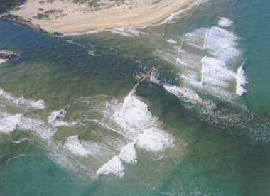
Photograph - Boat Harbour, Gippsland Ports, dredge April Hamer Lakes Entrance, 2006
... Waterways ...Colour aerial photograph of the Entrance from Bass Strait to the Gippsland Lakes showing rock entrance groynes, surf on beach, dredge April Hamer working in the channel Lakes Entrance Victoria. Also another copy size 15 x 19.5 cmwaterways, topography, beaches, ocean -
 Lakes Entrance Historical Society
Photograph - North Arm Lakes Entrance, M Holding, 2008
... Waterways ...Also two other colour photographs taken from Holding property showing twists and turns of North Arm number 03862.1 and 03862.2 sizes 10 x 15 cmColour photograph of North Arm views from D and K Holdings property Hunters Lane looking NNE Lakes Entrance Victoria people, tourism, waterways, lakes entrance -
 Lakes Entrance Historical Society
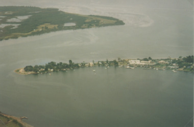
Photograph - Metung, 2005 c
... Waterways ...Colour aerial photograph of Shaving Point Gippsland Lakes looking eastward over Mosquito Point Bancroft Bay in between Metung Victoriaaerial photograph, settlement, waterways, metung -
 Lakes Entrance Historical Society
Photograph - Metung, 1995 c
... Waterways ...Colour aerial photograph of Shaving Point Gippsland Lakes with Mosquito Point bottom left hand corner Boole Poole on opposite shore Metung Victoriaaerial photograph, waterways, topography, metung -
 Lakes Entrance Historical Society
Book, Vantree Pty Ltd Shearwater Environmetal Management, East Gippsland - Creating a Community Heritage Plan, 2002
... Waterways ...This plan provides for the long-term Coastal Action Planwaterways, environment, tourism, boats and boating -
Lakes Entrance Historical Society
Domestic object - Souvenir China
... Waterways ...Photographs of SS Gippsland Mitchell River and Lakes Entrance on chinaSouvenir china cup, two plates and dishtourism, mementos, boats, waterways -
 Lakes Entrance Historical Society
Photograph, Lakes Post Newspaper, Cunninghame Arm Footbridge, . Lakes Entrance, 1999
... Waterways ...Colour photograph of the Cunninghame Arm Footbridge, . Lakes Entrancebridges, waterways, associations, topography -
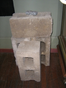 Harcourt Valley Heritage & Tourist Centre
concrete blocks, 1914
Charles Seelenmeyer conducted Concrete Utilities Limited (Harcourt Cement Pipe Factory). Operated in Harcourt circa 1914 to 1930 in premises situated opposite the ANA Hall on what is now the road reserve. Principal raw material was sand from the adjacent waterway ( Barkers Creek.) Principal output was concrete drainage tiles for use in district orchards but concrete blocks were also produced for construction of homes and commercial buildings. At a time of rapid expansion of the orchards this industry provided a vital piece of orchard infrastructure, mostly buried and not now visible but nevertheless a very important feature of the valley’s horticultural industry.. Homes built with these concrete blocks are a distinct part of Harcourt’s housing stock. Harcourt Cement Pipe Co was an example of local initiative to solve a local problem using local materials. A collection of 4 concrete building blocks -
University of Melbourne, Burnley Campus Archives
Plan, Albert Park, c.1994
Plans of sections of Albert Park by The Hassell Group, Lead Consultant Land Systems EBC, Melbourne Parks & Waterways. 1 copy laminated of each of: (1) 2 copies Albert Park Golf Course Proposal. (2) Ross Gregory Drive Precinct. (3) Lakeside Drive May 1994. (4) 2 copies New South Melbourne Soccer Ground. (5) 2 copies Aughtie Drive. (6) 2 copies Aughtie Drive Precinct. (7) 2 copies New Home for South Melbourne Cricket Club. (8) Final Proposed Strategy Plan: Realising the Vision, coloured, Key features of the plan on reverse. -
University of Melbourne, Burnley Campus Archives
Document - Survey, Roger Lord, 1998
... Waterways ...Survey form on educational and career informationroger lord, melbourne water, waterways, weed management, brushy creek (mooroolbark) -
 Hume City Civic Collection
Photograph
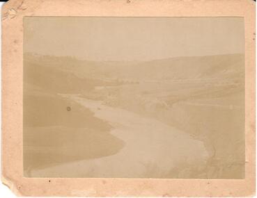
... waterways ...Deep Creek running from school to reserve where swimming took place. One of a series of 4 photographs of the Bulla Valley and Deep Creek.Faded black and white photo of Deep Creek. Mounted on cardboard.deep creek, bulla bridge, waterways, bulla, george evans collection -
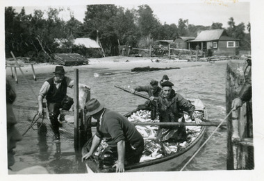 Lakes Entrance Historical Society
Photograph, 1947c
... Waterways ...Also black and white enlargement 11.5 x 16Black and white small format photograph of fishermen at the fish pens in lake at Western Side of entrance. Four men in rowing boat loaded with fish, one man on fence, another holding rope to steady boat. Fishermen's cottages in background. Lakes Entrance Victoriafishing industry, boats and boating, waterways, occupation, fish -
 Lakes Entrance Historical Society
Photograph - Flora Minter, Fish Marie, 2000 c
... Waterways ...Colour photograph of copy of Flora Minters painting of the PS Murray in Cunninghame Arm, 1860s/1870s. Below Merrangbaur Hill near old natural entrance to the lakes. Tug boat beside it, and row boat with people. Cottage on bank far left. Photographed from a book. Lakes Entrance Victoriaships and shipping, waterways, vegetation, painting, artist -
 Lakes Entrance Historical Society
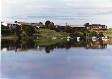
Photograph - Lakes Entrance, Tambo Shire, 1994 c
... Waterways ...Also second identical copyColour photograph of a section of the North Arm adjacent to Ferndale Parade, shows the rear view of six houses, five small boats moored at lake edge. Lakes Entrance Victoriajetties, houses, waterways, boats and boating, township -
 Lakes Entrance Historical Society
Photograph - Carpentertown, 1920c
... Waterways ...Copied from copy in J Whadcoat collectionBlack and white photograph showing P W D cottage on left and other Works buildings on dune at the entrance to Gippsland Lakes from the ocean - Bass Strait. View shows flagstaff on top of dune and flagstaff jetty in lake - Cunninghame Arm. Small sailing boat on left and other small craft on shoreline. Section of Bullock Island with vegetation, one telegraph pole and one dead tree on island. Shoreline of North arm in foreground. Lakes Entrance Victoriajetties, waterways, settlement, historic site, boats and boating -
 Lakes Entrance Historical Society
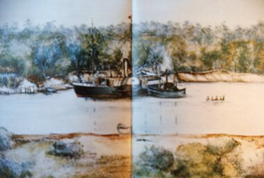
Photograph - New Works, 1910c
... Waterways ...Also black and white copy 12.5 x 18 cm with smear of purple ink in top left hand corner, purchased from Helen ClothierTinted black and white photograph showing boardwalk from New Works Jetty over the sand dunes with small shed on jetty, small one room Boole Poole school on right of boardwalk and harbour master's house on right. Club Hotel on opposite foreshore and town on far right. Kalimna escarpment in background, at Lakes Entrance, Victoria.View of Cunninghame Victoriaboardwalk, waterways, ships and shipping, township, topography -
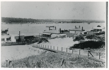 Lakes Entrance Historical Society
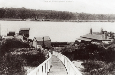
Photograph - Carpentertown, 1900c
... Waterways ...Also four other black and white copies, one size 12 x 18 cm, two size 9 x 14 cm, and one size 10 x 15 cm, one of which was purchased from Helen ClothierBlack and white photograph showing buildings on dunes, and township of Lakes Entrance across lake, Cunninghame Arm. Buildings from left are school, harbour masters house, harbour engineer's house. Boardwalk in foreground. Kalimna Hill in background. Lakes Entrance Victoriawaterways, vegetation, topography, township, historic buildings