Showing 2069 items matching "55"
-
 Glenelg Shire Council Cultural Collection
Photograph - Photograph - Aerial view of Thomas Borthwick and Sons abattoir and Walock Swamp, Nov-55
Port of Portland Authority archives.Front: (no inscriptions) Back: 'AIRSPY PHOTO' CD PRATT 86 McCracken St ref No2/B/73 Essendon Phone Fx 2840 Victoria Australiaport of portland archives, tb and s abattoir, walock swamp -
Glenelg Shire Council Cultural Collection
Photograph - Photograph - Main Breakwater construction, Portland, May-55
Port of Portland Authority ArchivesFront: Main b'water from Battery Point 10.5.55 (typed)port of portland archives, main breakwater, construction, portland harbour, harbour development, battery point -
 Bendigo Historical Society Inc.
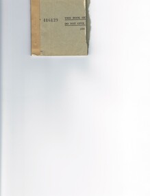
Document - MCCOLL, RANKIN AND STANISTREET COLLECTION: CHEQUE BUTTS, 1954/55
Cheque butts for Directors Fees and Share Dividends, dated 13 Sept. 1954 - 7 Feb. 1955. No name of account. 416129.MCCOLL RANKIN & STANISTREETorganization, business, gold mine shares., mccoll rankin & stanistreet -
 Bendigo Historical Society Inc.
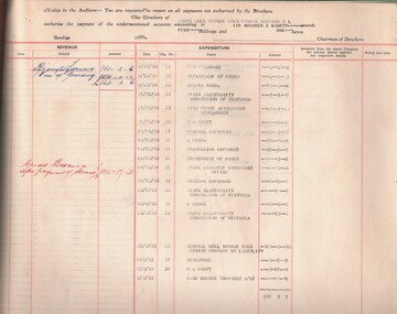
Book - MCCOLL, RANKIN AND STANISTREET COLLECTION: ACCOUNTS FOLIO, 1950/55
Book; accounts folio - revenue & expenditure South Nell Gwynne Gold Mining Co. N.L. Hard cover - brown. Loose leaf with brass screws. South N. Gwynne printed & uncerlined - top right hand corner of front cover.MCCOLL RANKIN & STANISTREETorganisation, industry, accounting., mccoll rankin & stanistreet -
 Bendigo Historical Society Inc.
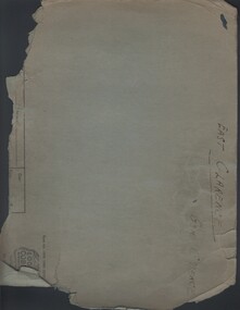
Document - MCCOLL, RANKIN AND STANISTREET COLLECTION: EAST CLARENCE: GENERAL CORRESPONDENCE, 1947/55
Documents; Cardboard folder (green) with 2 hole binder, containing correspondence from 2/1/1947 to 10/8/1955. East Clarence - General correspondence.MCCOLL RANKIN & STANISTREETorganization, business, gold mining, mccoll rankin & stanistreet -
 Port Melbourne Historical & Preservation Society
Photograph - Construction of rock wall at George Samuel Walter Memorial Garden, Jack GOULD, C. 1950-55
From a box of photographs in Nancy U'REN's papers used during research for her thesis, The Early Growth and Development of Sandridge (1976) and/or her book with Noel TURNBULL, A History of Port Melbourne (1983). Black and white photograph showing Crockford Street as it turns into Bay Street. A worker is bent over on the edge of George Samuel Walter Memorial Garden next to a pile of rocks beginning the construction of the rock wall.bay street, crockford street, port melbourne town hall, george samuel walter memorial garden, nancy u'ren nee morris -
 Bendigo Historical Society Inc.
Document - MCCOLL, RANKIN AND STANISTREET COLLECTION: GOLDEN CARSHALTON/SOUTH NELL GWYNNE - CHEQUE BOOK, 1952/55
Documents: double height cheque book from The English, Scottish, & Australian Bank Ltd Bendigo Victoria.front section has some cheques already signed by director from Golden Carshalton NL - rear section has cheques signed by director for South Nell Gwynne GM Co.NL. Cheques stamped with mine name, manager, director .MCCOLL RANKIN AND STANSISTREETorganization, business, gold mine accounting., mccoll rankin and stansistreet -
 Robin Boyd Foundation
Journal, The Architectural Review, Vol. 117, No. 700, Apr-55
Contains an article 'Machine Aesthetic' by Reyner Banham (pp 224-228). It also contains a book review by Raymond McGrath (pp 269-270) on Early Melbourne Architecture: 1840 to 1888, Edited by Maie Casey, Joan Lindsay, DA Casey, John Freeman, Tom Freeman, and Alan Henderson. Oxford Press, 1953.architecture, walsh st library -
University of Melbourne, Burnley Campus Archives
Letter - Correspondance, 1953-55
Correspondence with past students of Burnley College -
 Clunes Museum
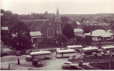
photograph, 1950-55
PHOTOGRAPH TAKEN FROM NEAR THE OLD FIRE BRIGADE HALL LOOKING TOWARDS METHODIST CHURCH ON THE OCCASION OF A PLEEASANT SUNDAY AFTERNOON SERVICE. BUSES FROM BALLARAT AND SURROUNDING TOWNS FERRIER THE VISITORS. SERVICE STREET, CLUNES.BLACK AND WHITE PHOTOGRAPH OF METHODIST CHURCH ONE SUNDAY AFTERNOON. THE OCCASION WAS A PLEASANT SUNDAY AFTERNOON SERVICE WITH BUSES AND CARS TO TRANSPORT THE VISITORS. SERVICE STREET, CLUNES.local history, document, postcard, churches, wesley -
Moorabbin Air Museum
Administrative record (item) - RAAF Wirraway Aircraft Servicing And Maintenance Form E/E.77 Travel Copy - A20-723, Royal Australian Air Force, Travel Copy: Aeroplane Maintenance Form E/E. 77, 27/04/55
Contains daily inspection and test flight records. Maintenance conducted at No 1 Basic Flight Training School, Uranquinty, New South Wales. -
Moorabbin Air Museum
Administrative record (item) - RAAF Wirraway Aircraft Servicing And Maintenance Form E/E.77 Travel Copy - A20-701, Royal Australian Air Force, Travel Copy: Aeroplane Maintenance Form E/E. 77, 23/02/55
Contains daily inspection and test flight records. -
Moorabbin Air Museum
Administrative record (item) - RAAF Wirraway Aircraft Servicing And Maintenance Form E/E.77 Travel Copy - A20-700, Royal Australian Air Force, Travel Copy: Aeroplane Maintenance Form E/E. 77, 21/04/55
Contains daily inspection and test flight records. -
Moorabbin Air Museum
Administrative record (item) - RAAF Wirraway Aircraft Servicing And Maintenance Form E/E.77 Travel Copy - A20-697, Royal Australian Air Force, Travel Copy: Aeroplane Maintenance Form E/E. 77, 16/09/55
Contains daily inspection and test flight records. -
Moorabbin Air Museum
Administrative record (item) - RAAF Wirraway Aircraft Servicing And Maintenance Form E/E.77 Travel Copy - A20-693, Royal Australian Air Force, Travel Copy: Aeroplane Maintenance Form E/E. 77, 16/09/55
Contains daily inspection and test flight records. -
Moorabbin Air Museum
Administrative record (item) - RAAF Wirraway Aircraft Servicing And Maintenance Form E/E.77 Travel Copy - A20-689, Royal Australian Air Force, Travel Copy: Aeroplane Maintenance Form E/E. 77, 07/03/55
Contains daily inspection and test flight records. Maintenance conducted at No 1 Basic Flight Training School, Uranquinty, New South Wales. -
Moorabbin Air Museum
Administrative record (item) - RAAF Wirraway Aircraft Servicing And Maintenance Form E/E.77 Travel Copy - A20-683, Royal Australian Air Force, Travel Copy: Aeroplane Maintenance Form E/E. 77, 07/03/55
Contains daily inspection and test flight records. Maintenance conducted at No 1 Basic Flight Training School, Uranquinty, New South Wales. -
Moorabbin Air Museum
Administrative record (item) - RAAF Wirraway Aircraft Servicing And Maintenance Form E/E.77 Travel Copy - A20-677, Royal Australian Air Force, Travel Copy: Aeroplane Maintenance Form E/E. 77, 01/03/55
Contains daily inspection and test flight records. Maintenance conducted at No 1 Basic Flight Training School, Uranquinty, New South Wales. -
Moorabbin Air Museum
Administrative record (item) - RAAF Wirraway Aircraft Servicing And Maintenance Form E/E.77 Travel Copy - A20-649, Royal Australian Air Force, Travel Copy: Aeroplane Maintenance Form E/E. 77, 01/12/55
Contains daily inspection and test flight records. Maintenance conducted at No 1 Basic Flight Training School, Uranquinty, New South Wales. -
 Tennis Australia
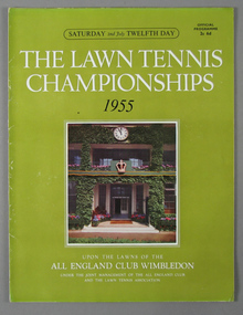
Tournament Programme, 2-Jul-55
Programme for the 12th Day matches during Wimbledon 1955. Materials: Ink, Paper, Metaltennis -
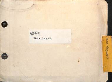 Ballarat Tramway Museum
Administrative record - Report, State Electricity Commission of Victoria (SECV), "Legend - Track gauges", 1954/55
Record shows the condition of the rail head at many points throughout the Ballarat system. Gives the type of rail, its weight, gauge, location and date of measurement See item 9127 for a report on the Special Work. Some sections measured in May 1954, rest May 1955Demonstrates a detailed report into the condition and wear of the Ballarat Tramways trackwork in 1954/1955.Report - within a manila card folder with steel clips containing about 44 drawings on drawing paper of rail sections.Outside cover in ink "Legend Track Gauges"ballarat, secv, trackwork, rails, reports -
 Eltham District Historical Society Inc
Photograph - Aerial Photograph, Landata, Eltham / Research, Vic, Jan. 1951
Centred on Brinkkotter Road opposite Yarramie Reserve, Eltham bounded by Maroondah Aqueduct to north, Nyora Road to south, Eltham College to east and Leane Drive to west. Historic Aerial Imagery Source: Landata.vic.gov.au Aerial Photo Details: Project No :65 Project : MELBOURNE AND METROPOLITAN PROJECT NO. 2 Run : 7 Frame : 8 Date : 01/1951 Film Type : B/W Camera : EAG9 Flying Height : 12200 Scale : 12000 Film Number : 1419 GDA2020 : 37°42'32"S, 145°10'41"E MGA2020 : 339408, 5824924 (55) Melways : 22 F3 (ed. 42)Historical aerial photos and photo maps provide viusal evidence of the chronology of changes to the built landscape of the district and assist in dating other imagesaerial photo, 1951-01, eltham, neil webster collection, brinkkotter road, eltham college, leane drive, maroondah aqueduct, melways 22f3, nyora road, yarramie reserve -
 Eltham District Historical Society Inc
Photograph - Aerial Photograph, Landata, Eltham, Vic, Jan. 1951
Centred on Beard Street between Main Road and Frank Street, Eltham bounded by Maroondah Aqueduct to north, Arthur Street to south, Maroong Drive to east and Catholic Ladies College to west. Historic Aerial Imagery Source: Landata.vic.gov.au Aerial Photo Details: Project No :65 Project : MELBOURNE AND METROPOLITAN PROJECT NO. 2 Run : 7 Frame : 9 Date : 01/1951 Film Type : B/W Camera : EAG9 Flying Height : 12200 Scale : 12000 Film Number : 1419 GDA2020 : 37°42'23"S, 145°09'39"E MGA2020 : 337874, 5825170 (55) Melways : 22 B3 (ed. 42)Historical aerial photos and photo maps provide viusal evidence of the chronology of changes to the built landscape of the district and assist in dating other imagesaerial photo, 1951-01, eltham, neil webster collection, arthur street, beard street, catholic ladies college, frank street, main road, maroondah aqueduct, maroong drive, melway 22b3, research (vic.) -
 Eltham District Historical Society Inc
Photograph - Aerial Photograph, Landata, Eltham North, Feb. 1956
Centred on present day 54 Kelway Crescent, Eltham North bounded by Glen Gully Road to north, Meruka Drive to south, Eltham College to east and Leach Street to west. Historic Aerial Imagery Source: Landata.vic.gov.au Aerial Photo Details: Project No :250 Project : MELBOURNE OUTER SUBURBS PROJECT Run : 17 Frame : 113 Date : 02/1956 Film Type : B/W Camera : EAG9 Flying Height : 10000 Scale : 12000 Film Number : 1176 GDA2020 : 37°42'16"S, 145°08'08"E MGA2020 : 335650, 5825336 (55) Melways : 21 G2 (ed. 42)aerial photo, 1956-02, eltham, eltham north, glen gully road, leach street, main road, melway 21g2, meruka drive, montmorency, neil webster collection -
 Eltham District Historical Society Inc
Photograph - Aerial Photograph, Landata, Montmorency, Feb. 1956
Centred on present day Tahlee Place Reserve and Sherbourne Preschool, Montmorency bounded by Progress Road to north, Withers Way to south, Main Road to east and Leach Street to west. Historic Aerial Imagery Source: Landata.vic.gov.au Aerial Photo Details: Project No :250 Project : MELBOURNE OUTER SUBURBS PROJECT Run : 17 Frame : 114 Date : 02/1956 Film Type : B/W Camera : EAG9 Flying Height : 10000 Scale : 12000 Film Number : 1176 GDA2020 : 37°42'50"S, 145°08'02"E MGA2020 : 335512, 5824286 (55) Melways : 21 F5 (ed. 42)aerial photo, 1956-02, neil webster collection, central park, eltham, leach street, main road, melway 21f5, montmorency, progress road, withers way, sherbourne preschool, tahlee place reserve -
 Eltham District Historical Society Inc
Photograph - Aerial Photograph, Landata, Lower Plenty, Feb. 1956
Centred on present day 217 Old Eltham Road, Lower Plenty bounded by Pitt Street to north, Yarra River to south, Main Road to east and Bonds Road to west. Historic Aerial Imagery Source: Landata.vic.gov.au Aerial Photo Details: Project No :250 Project : MELBOURNE OUTER SUBURBS PROJECT Run : 17 Frame : 116 Date : 02/1956 Film Type : B/W Camera : EAG9 Flying Height : 10000 Scale : 12000 Film Number : 1176 GDA2020 : 37°43'58"S, 145°07'49"E MGA2020 : 335237, 5822186 (55) Melways : 21 E10 (ed. 42)aerial photo, 1956-02, neil webster collection, eltham, main road, bonds road, elham, lower plenty, melway 21e10, pitt street, yarra river -
 Eltham District Historical Society Inc
Photograph - Aerial Photograph, Landata, Eltham, Feb. 1956
Centred on present day Shalbury Avenue, Eltham bounded by Leane Drive and Parsons Road to north, Nyora Road to south, Reynolds Road to east and the Diamond Creek to west Historic Aerial Imagery Source: Landata.vic.gov.au Aerial Photo Details: Project No :250 Project : MELBOURNE OUTER SUBURBS PROJECT Run : 18 Frame : 95 Date : 02/1956 Film Type : B/W Camera : EAG9 Flying Height : 10000 Scale : 12000 Film Number : 1176 GDA2020 : 37°41'57"S, 145°09'51"E MGA2020 : 338145, 5825965 (55) Melways : 22 C1 (ed. 42)aerial photo, 1956-02, neil webster collection, eltham, diamond creek (creek), melway 22c1, nyora road, parsons road, reynolds road, shalbury avenue -
 Eltham District Historical Society Inc
Photograph - Aerial Photograph, Landata, Research, Vic, Feb. 1956
Centred on present day Thompson Crescent, Research bounded by Maroondah Aqueduct to north, Thompson Crescent and Nyora Road to south, Bells Hill Road to east and Eucalyptus Road to west Historic Aerial Imagery Source: Landata.vic.gov.au Aerial Photo Details: Project No :250 Project : MELBOURNE OUTER SUBURBS PROJECT Run : 19 Frame : 6 Date : 02/1956 Film Type : B/W Camera : EAG9 Flying Height : 10000 Scale : 12000 Film Number : 1176 GDA2020 : 37°42'38"S, 145°11'02"E MGA2020 : 339927, 5824736 (55) Melways : 22 H4 (ed. 42)aerial photo, 1956-02, neil webster collection, bells hill road, eltham, eucalyptus road, maroondah aqueduct, melway 22h4, nyora road, research (vic.), thompson crescent -
 Eltham District Historical Society Inc
Photograph - Aerial Photograph, Landata, Research, Vic, Apr. 1963
Centred on present day Thompson Crescent and Nicholson Close, Research bounded by Maroondah Aqueduct to north, Nyora Road to south, Eltham College to east and Eltham Gateway Hotel to west. Historic Aerial Imagery Source: Landata.vic.gov.au Aerial Photo Details: Project No :486 Project : MELBOURNE (1963) PROJECT Run : 5 Frame : 61 Date : 04/1963 Film Type : B/W Camera : RC8 Flying Height : 5100 Scale : 9600 Film Number : 1805 GDA2020 : 37°42'24"S, 145°10'06"E MGA2020 : 338528, 5825143 (55) Melways : 22 D3 (ed. 42)aerial photo, neil webster collection, eltham, 1963-04, eltham college, eltham gateway hotel and conference centre, maroondah aqueduct, melway 22d3, nicholson close, nyora road, research (vic.), thompson crescent -
 Eltham District Historical Society Inc
Photograph - Aerial Photograph, Landata, Eltham, Vic, Apr. 1963
Centred on present day John Street, Eltham between Main and Bible streets bounded by Elsa Court to north, Main Road Bridge to south, Wattle Grove to east and Bolton Street to west. Historic Aerial Imagery Source: Landata.vic.gov.au Aerial Photo Details: Project No :486 Project : MELBOURNE (1963) PROJECT Run : 6 Frame : 123 Date : 04/1963 Film Type : B/W Camera : RC8 Flying Height : 5100 Scale : 9600 Film Number : 1805 GDA2020 : 37°43'12"S, 145°08'54"E MGA2020 : 336800, 5823623 (55) Melways : 21 J6 (ed. 42)aerial photo, neil webster collection, 1963-04, bolton steet, elsa court, eltham, john street, main road, main road bridge, melway 21j6, wattle grove