Showing 1035 items matching "diagrams"
-
 Moorabbin Air Museum
Manual (Item) - Air Publication 2001A Vol II part3. Includes many good coloured diagrams, Repair instructions for Buckingham I Aircraft
-
Moorabbin Air Museum
Manual (Item) - Detailed notes and diagrams, B24 D and J Bombardment airplane General Service notes
-
Moorabbin Air Museum
Manual (Item) - Includes diagrams and calculations, Department of Aircraft Production Beaufort Division Fisherman's Bend
-
Moorabbin Air Museum
Booklet (Item) - Listing of US airports Diagrams showing landing and take off procedures, Army air forces instrument let-down procedures
-
Moorabbin Air Museum
Manual (Item) - Cessna Avionics Wiring Diagram Serial No. S550-0118
-
Moorabbin Air Museum
Manual - Argosy 650 Series Wiring Diagram Manual, Argosy 650 Series
-
Moorabbin Air Museum
Manual (item) - ASTA Nomad N24 Wiring Diagram Manual
-
Moorabbin Air Museum
Booklet (Item) - 36 pages of notes including cockpit instrument layout diagram, AP 2210 C P N Meteor 3 pilots notes
-
Moorabbin Air Museum
Booklet (Item) - 45 pages of pilot and flight engineers notes and schematic diagrams Mk 1 Mk VII Mk III and X, Lancaster pilots notes
-
Moorabbin Air Museum
Document (Item) - cockpit instruments electric circuit diagrams, Beechcraft D18 S
-
Hand Tool Preservation Association of Australia Inc
Diagram
This item is part of the Thomas Caine Tool Collection, owned by The National Trust of Australia (Victoria) and curated by the Hand Tools Preservation Association of Australia.Dimentions of manhole gasket + mudhole -
 National Wool Museum
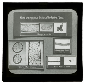
Photograph - Wool Fibre Diagrams, J W Allen, 1900 - 1940
This item is part of a collection of four black and white glass lantern slides previously housed together in a glass plate box. The slides are part of a greater collection of around forty three black and white glass lantern slides, along with other photographs and photo albums related to this collection. This item is associated with the New South Wales Graziers Association world tour of merino sheep 1928/9. The slides were possibly used as supporting material in presentations made by J W Allen when on tour.Black and white glass lantern slide with paper edging depicting four cards with mirco-photographs of wool fibres.[handwritten] WELSHagriculture, new south wales graziers association, travel, sheep, breeding, photography, glass lantern slides, j w allen -
Friends of Ballarat Botanical Gardens History Group
Work on paper - A Diagram of Guns in the Ballarat Botanical Gardens, Muzzle Loaded Guns
john garner collection, ballarat botanical gardens, gardens, ballarat, guns -
 Mont De Lancey
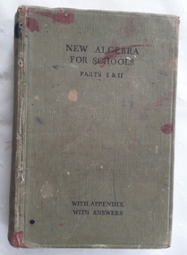
Book, Clement V. Durell, A New Algebra for Schools Parts 1 and 2 - on a separate sheet a Correspondence School Secondary Section. Terminal Report for Lance Sebire No. 1299 1st Test 1st Year 1940, 1930, 1936 Reprint
This is an Algebra textbook for secondary students with an Appendix at the back with Answers along with Supplementary Exercises and tests. Included are illustrations, diagrams and charts. The cover is badly ink stained, loose pages with pencil markings are visible throughout.Very stained grey cloth bound hardcover New Algebra for Schools Parts, 1 and 2 with Appendix and Answers by Clement V. Durell, M.A. Included in the book is a Correspondence School Secondary Section Terminal Report no. 1299 for Lance Sebire 1st test 1st Year 1940. It is signed by his parent, Thomas Sebire.328p. plus Appendix 66p.non-fictionThis is an Algebra textbook for secondary students with an Appendix at the back with Answers along with Supplementary Exercises and tests. Included are illustrations, diagrams and charts. The cover is badly ink stained, loose pages with pencil markings are visible throughout.mathematics, textbooks, algebra -
 Mont De Lancey
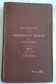
Book, C. French, F.L.S., F.R.H.S, A Handbook of the Destructive Insects of Victoria, with notes on the methods to be adopted to check and extirpate them, 1893
A handbook of the destructive insects of Victoria with notes on the methods to be adopted to check and extirpate them with useful diagrams and illustrations of machines and pumps and the plants.A brown hardcover handbook with the title printed in gold lettering on the front cover Handbook of the Destructive Insects of Victoria Part II by C. French, F.L.S., F.R.H.S., Government entomologist with the price 2/6. at the bottom right hand corner. The spine has the title and author printed in gold. T. Sebire March 29th 1894 is written in black ink on the top right of the title and contents pages. There are coloured plates and black and white illustrations, an appendix and drawings of various pumps and equipment required for use. Loose pages, some tears, and tanning is noted. 222p. non-fictionA handbook of the destructive insects of Victoria with notes on the methods to be adopted to check and extirpate them with useful diagrams and illustrations of machines and pumps and the plants.agriculture, pest control, entomology -
 Wodonga & District Historical Society Inc
Album - Hume Reservoir Australia Album - Detail plan and explanation, Department of Public Works, N.S.W, 1927
This set of photos is from a leather bound album bearing the inscription "HUME RESERVOIR AUSTRALIA" plus 'The Rt. Hon. L. C. M. S. Amery, P. C., M .P.' all inscribed in gold. It was presented to The Rt. Hon. L. C. M. S. Amery, P. C., M. P, Secretary of State for Dominion Affairs on the occasion of his visit to the Hume Reservoir on 2nd November 1927. This album is of local and national significance as it documents the planning and development of the Hume Reservoir up to 1927. It was the largest water reservoir in the British Empire. The album records the pioneering engineering work that went into its construction.2. Detail Plan and Section. Starting from the New South Wales and there will be an earthen embankment 430 feet 6 inches long which is retained by the North Wing Wall. Then come the sluice section 284 feet 3 inches long, the spillway 720 feet long and the South Wing Wall, making a total length of 1,042 feet 6 inches of concrete wall. Beyond the South Wing Wall is earth embankment again to a length of 3,827 feet. The Full Supply Level is R.L.626.00 and allowance has been made for a surcharge of 9 feet. A road will run along the top of the dam at R.L.642.00. The sluice section contains seven offlets, the three nearest the north wing wall being 13 feet in diameter for hydro-electric purposes and the other four 9 feet in diameter for regulation purposes only. There are to be stony sluice gates on the upstream ends of the outlets and needle valves on the downstream ends. The shock of the discharged water will be taken by a stilling pool. Trash racks will protect the intake ends of the outlets. Next comes the spillway section, which is curved on the downstream face, and carried up to within 15 feet of the full supply level. Above that will be a series of piers between which will be the flood gates and on top of which the roadway will be carried. The gates will be 20 feet wide and 15 feet high and will be 29 in number. They will slide down the face of the wall when opened for the escape of the water. The investigation of the control of this cascade of water was made by means of a model and as a result the form of “bucket” or energy dissipater shown on the section of the spillway was decided upon. The earth embankment in Victoria is being constructed by the State Rivers and Water Supply Commission of Victoria who are the Constructing Authority for that State under the River Murray Waters Agreement. The core of the embankment is of concrete 6 feet wide at the base tapering to 2 feet at the top end and is reinforced with steel rods from the level of the decomposed rock upwards. On the downstream side, at about natural surface level, is a tunnel for drainage and inspection purposes. Above the tunnel is a vertical layer of large stones to drain any seepage to the tunnel. Against the core wall is packed selected material of as impervious a character as can be got locally and beyond that the bank is carefully built up in horizontal layers by means of horses and wheel scoops. The upstream slope is 3-to-1 hardening to 2½-to-1 at the top and the downstream slope is 2½-to-1 hardening to 2.07-to-1 at the top. The thrust of the upstream toe is taken by a mass of granite blocks, and this face is protected by concrete laid in situ. The width of the bank at base is 650 feet and at top 32 feet.hume reservoir australia, river murray waters scheme, hume weir diagrams, hume plan details -
 Wodonga & District Historical Society Inc
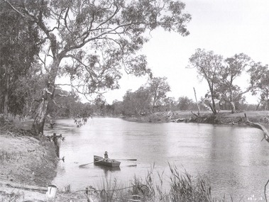
Album - Hume Reservoir Australia Album - View of site on 28th November 1919
This set of photos is from a leather bound album bearing the inscription "HUME RESERVOIR AUSTRALIA" plus 'The Rt. Hon. L. C. M. S. Amery, P. C., M .P.' all inscribed in gold. It was presented to The Rt. Hon. L. C. M. S. Amery, P. C., M. P, Secretary of State for Dominion Affairs on the occasion of his visit to the Hume Reservoir on 2nd November 1927. This album is of local and national significance as it documents the planning and development of the Hume Reservoir up to 1927. It was the largest water reservoir in the British Empire. The album records the pioneering engineering work that went into its construction.DEPARTMENT OF PUBLIC WORKS, N.S.W. RIVER MURRAY WATERS SCHEME. HUME RESERVOIR. 3. View of site on 28th November 1919 when the first sod was turned by the Governor General Sir Ronald Munro Ferguson, now Lord Hovar. The view is taken from the New South Wales end of the dam looking across the Murray to Victoria. The Murray flows from left to right.hume reservoir australia, river murray waters scheme, hume weir diagrams, hume plan details -
 Wodonga & District Historical Society Inc
Album - Hume Reservoir Australia Album - The River Murray at the site of the dam 28th November, 1919
This set of photos is from a leather bound album bearing the inscription "HUME RESERVOIR AUSTRALIA" plus 'The Rt. Hon. L. C. M. S. Amery, P. C., M .P.' all inscribed in gold. It was presented to The Rt. Hon. L. C. M. S. Amery, P. C., M. P, Secretary of State for Dominion Affairs on the occasion of his visit to the Hume Reservoir on 2nd November 1927. This album is of local and national significance as it documents the planning and development of the Hume Reservoir up to 1927. It was the largest water reservoir in the British Empire. The album records the pioneering engineering work that went into its construction.DEPARTMENT OF PUBLIC WORKS, N.S.W. RIVER MURRAY WATERS SCHEME. HUME RESERVOIR. The River Murray at the site of the dam on 28th November 1919 looking upstream. hume reservoir australia, river murray waters scheme, hume weir diagrams, hume plan details -
 Wodonga & District Historical Society Inc
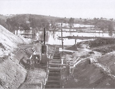
Album - Hume Reservoir Australia Album - Foundations for core wall of earth embankment, September 1921
This set of photos is from a leather bound album bearing the inscription "HUME RESERVOIR AUSTRALIA" plus 'The Rt. Hon. L. C. M. S. Amery, P. C., M .P.' all inscribed in gold. It was presented to The Rt. Hon. L. C. M. S. Amery, P. C., M. P, Secretary of State for Dominion Affairs on the occasion of his visit to the Hume Reservoir on 2nd November 1927. This album is of local and national significance as it documents the planning and development of the Hume Reservoir up to 1927. It was the largest water reservoir in the British Empire. The album records the pioneering engineering work that went into its construction.DEPARTMENT OF PUBLIC WORKS, N.S.W. RIVER MURRAY WATERS SCHEME. HUME RESERVOIR. 5. Foundations for core wall of earth embankment in New South Wales in September 1921. The River Murray in flood.hume reservoir australia, river murray waters scheme, hume weir diagrams, hume plan details -
 Wodonga & District Historical Society Inc
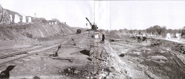
Album - Hume Reservoir Australia Album - Excavations for foundations of spillway, September 1921
This set of photos is from a leather bound album bearing the inscription "HUME RESERVOIR AUSTRALIA" plus 'The Rt. Hon. L. C. M. S. Amery, P. C., M .P.' all inscribed in gold. It was presented to The Rt. Hon. L. C. M. S. Amery, P. C., M. P, Secretary of State for Dominion Affairs on the occasion of his visit to the Hume Reservoir on 2nd November 1927. This album is of local and national significance as it documents the planning and development of the Hume Reservoir up to 1927. It was the largest water reservoir in the British Empire. The album records the pioneering engineering work that went into its construction.DEPARTMENT OF PUBLIC WORKS, N.S.W. RIVER MURRAY WATERS SCHEME. HUME RESERVOIR. 6. Excavation in progress for foundations of outlet and spillway sections of dam. September 1921.hume reservoir australia, river murray waters scheme, hume weir diagrams, hume plan details -
 Wodonga & District Historical Society Inc
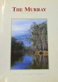
Book - THE MURRAY, Norman Mackay and David Eastburn, 1990
A study of the Murray River system, commissioned by the Murray Darling Basin Commission and published in 1990. This book provided a starting point for the understanding needed to make sustainable development og the Murray-Darling system an achievable goal. It provides a basis for action to halt futher degradation of the River and to rehabilitate its damaged environment. The picture that emerges from this volume is of a river in decline but not yet beyond saving. It covers topics such as groundwater and salinity, the associated fauna and flora, the surrounding environment, and the human impact. Illustrated with maps, diagrams and colour photographs. Includes a glossary and an index.non-fictionA study of the Murray River system, commissioned by the Murray Darling Basin Commission and published in 1990. This book provided a starting point for the understanding needed to make sustainable development og the Murray-Darling system an achievable goal. It provides a basis for action to halt futher degradation of the River and to rehabilitate its damaged environment. The picture that emerges from this volume is of a river in decline but not yet beyond saving. It covers topics such as groundwater and salinity, the associated fauna and flora, the surrounding environment, and the human impact. Illustrated with maps, diagrams and colour photographs. Includes a glossary and an index.upper murray region, murray river ecology, stream ecology murray river -
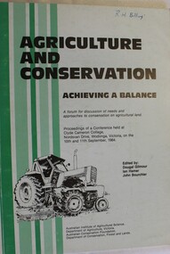 Wodonga & District Historical Society Inc
Book - Agriculture and Conservation - Achieving a Balance, Australian Institute of Agricultural Science, September 1984
This publication documents the proceedings of a conference held at Clyde Cameron College, Nordsvan Drive, Wodonga, Victoria on the 10th and 11th September, 1984. It includes maps, diagrams and bibliographical references. Some of the topics included in the keynote addresses are:- soil degradation, the use of chemicals in agriculture, agriculture and the use of public land, prime agricultural land, management of native plants and animals on farms, water resource management, economics of conservation and rights and responsibilities of individuals in the use of freehold land.non-fictionThis publication documents the proceedings of a conference held at Clyde Cameron College, Nordsvan Drive, Wodonga, Victoria on the 10th and 11th September, 1984. It includes maps, diagrams and bibliographical references. Some of the topics included in the keynote addresses are:- soil degradation, the use of chemicals in agriculture, agriculture and the use of public land, prime agricultural land, management of native plants and animals on farms, water resource management, economics of conservation and rights and responsibilities of individuals in the use of freehold land.agriculture, conservation, land degradation -
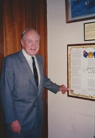 Melbourne Legacy
Photograph, President Stevenson with a diagram of Harefield Cemetery, 1993
Photo of Legatee John Stevenson, he was President in 1993. He is standing next to a mounted poster showing a plan of the graves at Harefield ANZAC Cemetery in the UK. More details of the cemetery in another record. Not sure if the poster once hung at Melbourne Legacy or if it was elsewhere. The photo was stored with other photos of an event at Northcote RSL.A photo of a past president.Photo of Legatee John Stevenson, standing next to a mounted poster showing a plan of the graves at Harefield ANZAC Cemetery in the UK.cemetery, john stevenson, harefield -
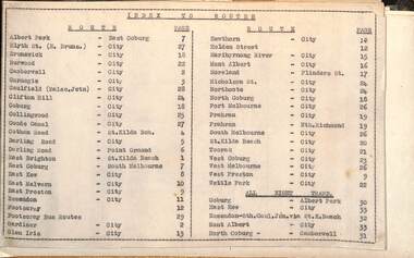 Melbourne Tram Museum
Administrative record - Tram fare route diagrams or maps, Melbourne & Metropolitan Tramways Board (MMTB), 1930s
The route maps give for each tram, including cable trams, and bus routes, a map of the fare structure, sections, all-night routes, details of transfers and tickets such as combined tickets. Not dated as such but sheet 1 has a note regarding the East Brighton - St Kilda route that it was out of date from 16/10/1938.Yields information about the MMTB fare structure for tram, and bus routes during the 1930s.Album brown card heavy card coves, secured with two interscrews containing a type index, 33 cartridge paper sheets with ink drawings and six loose sheets. Hand drawn in black, red and green ink.mmtb, tramways, fares, maps, routes, buses, cable trams -
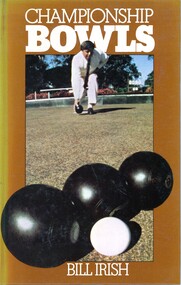 Heidelberg Golf Club
Book, Bill Irish, Championship Bowls / by Bill Irish, 1979
Diagrams and discussions of game situations and techniques in the sport of lawn bowls.79 p., illus.non-fictionDiagrams and discussions of game situations and techniques in the sport of lawn bowls.heidelberg golf club bowling club, lawn bowls, bowling -
Moorabbin Air Museum
Manual (Item) - Includes detailed diagrams and flow charts The manual is 80mm thick, Erection and maintenance instructions for C-54 (Army) and R5D (navy) models
-
Moorabbin Air Museum
Manual (Item) - Includes very detailed parts listing and circuit diagrams The manual is 150mm thick, Metropolitan 440 convair maintenance manual
-
Moorabbin Air Museum
Manual (Item) - Includes very detailed parts listing and circuit diagrams The manual is 150mm thick, Convair metropolitan 440 illustrated parts catalogue
-
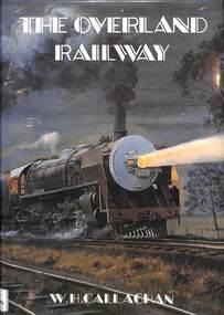 Victorian Railway History Library
Book, Callaghan, W.H, The Overland Railway, 1992
A history of the South line from Adelaide to Serviceton with track diagrams of the stations.ill, maps, p.314.non-fictionA history of the South line from Adelaide to Serviceton with track diagrams of the stations.railraod construction - south australia - history, railroad operations - south australia - history -
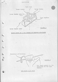 Moorabbin Air Museum
Document (Item) - (SP) Diagrams relating to Gyroscopes scientific use and effect
Possibly related to navigation