Showing 1119 items matching "land development"
-
 Surrey Hills Historical Society Collection
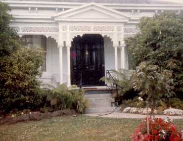
Photograph, 101 Guildford Road, Surrey Hills
The house was built in 1883, possibly to encourage development of housing on the first urban land subdivision in Surrey Hills, the Windsor Park Estate (in the Windsor Crescent area). This coincided with the opening of the Surrey Hills Railway station. The first occupant was John Brown Nicholson, police magistrate. In 1884 the foundation meeting of the Wyclif Congregational Church was held in the house.Colour photo of the front door and verandah of 101 Guildford Road taken from the street. The house is Victorian in style with ornate lacework along the verandah. It is painted white and has a slate roof. There is a well-maintained garden with flower beds and shrubs, which partially obscure the house.victorian style, wyclif church, houses, guildford road, john brown nicholson -
 Surrey Hills Historical Society Collection
Book, Blackburn: A Picturesque History, 1978
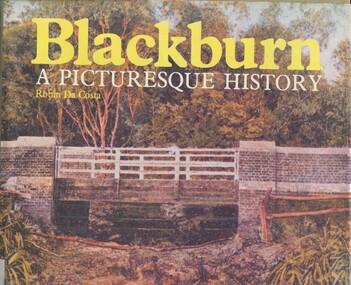
This book focuses on the area's history and traces the development through settlement, adaptation and consolidation to the present. It discusses the history of early families, the railway, land boomers, churches and school. Robin da Costa, later Mrs Robin da Costa- Adams, came to live in Balwyn Road, Canterbury and joined the Canterbury History Group.Hardback book of 144 pages, indexed with multiple black and white photos.In Jocelyn Hall's writing: "Donated to Surrey Hills Neighbourhood Centre".(mr) james blackburn, meader's travellers' rest hotel, blackburn hotel, blackburn post office, blackburn railway station, blackburn pioneers, blackburn company, (mr) george augustus goodwin, (mr) thomas r b morton, blackburn brick works, st john's anglican church, blackburn methodist church, blackburn church of christ, blackburn presbyterian church, st thomas the apostle peace memorial church, seagoe common school, the courier blackburn, blackburn library, blackburn primary school, blackburn open-air school, blackburn creek hotel, blackburn college, blackburn kindergarten, newark grammar, blackburn hall, morton park, blackburn lake sanctuary, backhouse's dairy, blackburn lake, wandinong sanctuary, barelli bakehouse, blackburn cool store, blue moon fruit co-operative ltd, 1st blackburn scouts troop, blackburn and district tree preservation society, hotels, (ms) robin da costa -
 Surrey Hills Historical Society Collection
Book, An historical geography of Surrey Hills, 1882-1913, 1979
A thesis submitted for the Degree of Bachelor of Arts with Honours. This thesis presents in a description form, the development of Surrey Hills, an eastern suburb of Melbourne. The settlement and growth from a rural district in 1882 to a suburban centre in 1913.This thesis presents in a description form, the development of Surrey Hills, an eastern suburb of Melbourne. The settlement and growth from a rural district in 1882 to a suburban centre in 1913.surrey hills, geography, topography, j. knipe, land use, population -
 Surrey Hills Historical Society Collection
Book, An historical geography of Surrey Hills, 1882-1913, 1979
A thesis submitted for the Degree of Bachelor of Arts with Honours. This thesis presents in a description form, the development of Surrey Hills, an eastern suburb of Melbourne. The settlement and growth from a rural district in 1882 to a suburban centre in 1913.This thesis presents in a description form, the development of Surrey Hills. The settlement and growth from a rural district in 1882 to a suburban centre in 1913.surrey hills, geography, topography, j. knipe, land use, population -
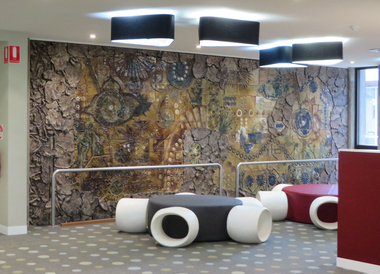 Federation University Art Collection
Artwork, other - Ceramic mural, John Gilbert, 'Enigmatic Land' by John Gilbert, 1973, 1973
ENIMATIC LAND OF BIRDS THAT SING FLOWERS FROMS SEEDS THAT SPRING OF REPTILES AND FISHES CREATURES FROM THE BEGINNING SUN AND MAN AND SCIENCE THE SYMBOLS THAT SILENTLY BUILD AND CHANGE IN COOL AND WARM YOU ARE THERE AND HERE OF YESTERDAY NOW THE SPLITTING EARTH MURAL BY JOHN GILBERT 1973John GILBERT (1935- ) Born Albury, New South Wales John Gilbert worked as a teacher while completing a Certificate of Art at the Technical College in Marlborough, before moving to Ballarat in 1958. He studied at the Ballarat Technical Art School, a division of the Ballarat School of Mines (1960-1961) receiving a Diploma of Art; and Croydon College of Art, London. Gilbert was a Senior Lecturer at the Ballarat Institute of Advanced Education (now Federation University) Art Department until his retirement in the late 1970s. In John Gilbert's Mount Helen studio he produced work marked with an incised 'Gilbert'. He had acquired a concern for form and an interest in sculpture from his teacher Neville Bunning, and from the British potter Hans Coper, whom he visited in 1968. He established two potteries in Ballarat , the Edinburgh Pottery (1972-2005) located within the Sovereign Hill precinct, and the Old Ballarat Pottery (1973-1994) located in the Old Ballarat Village opposite Sovereign Hill. This item is part of the Federation University Art Collection. The Art Collection features over 2000 works and was listed as a 'Ballarat Treasure' in 2007.A large ceramic mural by John Gilbert commissioned for the wall of the E.J. Barker Library. The mural features brown and green glaze with features of indigo. The work has no particular pictorial representation. It is an arrangement of colour and form, designed for enjoyment rather than to analyse. The theme relates to the development of the Universe through basic symbols such as plant forms, fish, birds and to mans development through symbols of science and engineering. The outer edge is symbolic of earths crust being peeled away to reveal science and nature. The mural depicts the changing of seasons from Winter to Summer (left to right). The mural was completed at John Gilbert's Slate Gallery studio, Mount Helen, and took eight months to make.gilbert, artwork, john gilbert, art, ballarat school of mines, mural, ballarat institute of advanced education, ballarat pottery, ceramics, old ballarat pottery, edinburgh pottery -
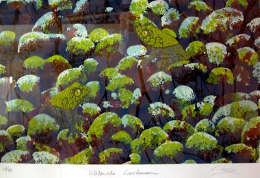 Federation University Art Collection
Work on paper - Printmaking - Silkscreen, Lin Onus, 'Walawala Garrkman' by Lin Onus, 2001
Lin ONUS (1948-1996) Language: Wiradjuri / Yorta Yorta Lin Onus played a pivotal role in the recognition of Aboriginal art as an expression of a contemporary and dynamic living culture. Prior to his premature death at just 47 years of age he was a prominent, strident, yet non-confrontational agent in renegotiating the history of colonial and Aboriginal Australia. His father, Bill Onus, was the founder of the Aboriginal Advancement League in Victoria and a prominent maker of artefacts in Melbourne. As a young Koori growing up, Lin lived in a cultural environment that included exposure to visiting Aboriginal artists, including Albert Namatjira. He began his artistic life assisting his father in decorating artifacts, went on to develop skills working with metal and painting with air brush as a panel beater; and by 1974 he was painting watercolors and photo-realist landscapes. In the 1970's he completed a set of paintings on the first Aboriginal guerrilla fighter Mosquito, which holds pride of place on the walls of the Advancement League in Melbourne, to this day. Lin Onus was a largely self-taught artist. Particularly important in his development was his visits to Garmedi (Arnhem Land) starting in 1986. Jack Wunuwun, the Yolngu artist, introduced him into the Murrungun-Djinang clan and gave him permission to use some of traditional images in his paintings. His cultural education on the Aboriginal side was also provided by visits to Cummeragunja with his father, and stories told by his uncle Aaron Briggs, known as 'the old man of the forest' who gave him his Koori name - Burrinja, meaning 'star'. They would sit on the banks of the Murray River within view of the Barmah Forest, Lin's spiritual home, the subject of many of his later paintings and his final resting place. Lin's father had been of the Yorta Yorta people from the Barmah Forest country, and Lin also used images from this area in his paintings. The images in his works include haunting photorealist portrayals of the Barmah red gum forests of his father's ancestral country, and the use of rarrk cross-hatching-based based painting style that he learned (and was given permission to use when in Arnhemland). His painting Barmah Forest won Canberra's national Aboriginal Heritage Award in 1994. (http://www.cooeeart.com.au/aboriginal_artist/lin_onus/A, accessed 18 May 2015) This item is part of the Federation University Art Collection. The Art Collection features over 1000 works and was listed as a 'Ballarat Treasure' in 2007.Framed limited edition silkscreen.Signed 'Onus' lower right (posthumously by Tiriki Onus) Edition 68/80art, artwork, lin onus, onus, printmaking, screenprint, aboriginal, dreaming, frogs, available -
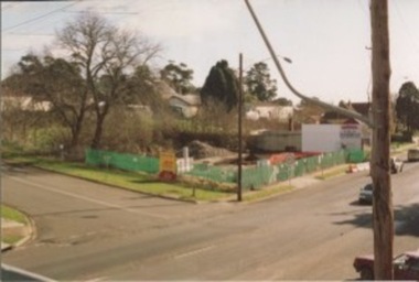
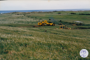 Port Fairy Historical Society Museum and Archives
Photograph
... beach development Coloured photograph of Land works near South ...South Beach DevelopementColoured photograph of Land works near South Beach with earth moving equipmentsouth beach, development -
 University of Melbourne, Burnley Campus Archives
Article, Ruth Beilin, From Soil Conservation to Land Husbandry the Midwife Effect: the Australian Landcare Landscape, c.1999
soil conservation, land husbandry, landcare, ruth beilin, senior lecturer -
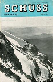 Falls Creek Historical Society
Journal - Schuss Vol. 19. No. 2 March - April 1953
Schuss was advertised as Victoria’s Official Ski Journal It was issued monthly from 1935 to 1961 except during the war when summer issues covered two months. This continued after the war, but it averaged 10 issues annually over its 25 year life. Schuss was published by the Ski Club of Victoria which had a membership of 38 Ski Clubs and demanded to be recognised as the prime authority on skiing in the state. The other 30 ski clubs with 85% of the members disagreed and the politics of skiing became heated. These clubs formed the Federation of Victorian Ski Clubs with their own journal, Ski Horizon. With the establishment of the Victorian Ski Association, Ski-Horizon published its last issue in Nov - Dec. 1955 and the role of the official journal was fully taken over by “Schuss”. This item is significant because it contains stories, images and information documenting the development of the ski industry in Victoria.The journal features stories and events chronicling developments in Victoria and internationally. Items related to the Falls Creek Area in this issue include:- Cover - Features a photo by H.Gibbs titled "Western Cliffs of Mt. Bogong" Page 65 - BOB HYMANS reported news of Falls Creek. At his own Ski School, notable improvements to accommodation have been made and additions to the building itself, which will make it very much more comfortable and serviceable to visitors. Water supply and heating are amongst the items in hand. Bob has acquired a Land Rover which will be a power of assistance to him in maintaining fresh supplies and in servicing his project generally. Kiewa Valley Ski Club members are making splendid progress with the erection of their Lodge. This is the latest building addition in that area and raises the number of clubs resident there to nine. Nissen Ski Tow members intend to operate their tow on the upper slopes of Falls Creek every day during the coming season that conditions permit. They are to be warmly commended on their enterprise. Page 65 - Advertisement for Bob Hymans' Ski School and Lodgeschuss journal, bob hymans, kiewa valley ski club, nissen tow -
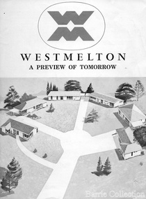 Melton City Libraries
Document, West Melton: A preview of tomorrow, c.1969
"In April 1969, the first major residential development in Melton began with the release of 148 homes for purchase. This was the first stage of a staggered release of a planned 30,000 homes for 100,000 people by 1990. The development, called Westmelton Satellite City, was described as ‘a preview of tomorrow’.101 It was the first estate built in a ‘modern’ style, with curved streets, and dozens of culs de sac. Westmelton was also the first major development in Victoria to build all the supply lines to the houses – including electricity and telephone lines – underground. The six different home designs in Westmelton were ‘specially designed for the future’, and with allotments ten feet wider than regulations required, there was plenty of ‘space for gracious living’ and for a family swimming pool. The developers of this new estate were active in promoting Westmelton as a new community within the Shire of Melton. By 1971, the Westmelton City News reported that Ian McIntosh, General Manager of Westmelton, had given away $100,000 on behalf of the company ‘to aid community projects’. This included a $72,000 donation towards building a community centre in Westmelton, and $25,000 for the shire’s Olympic-sized swimming pool. Ian McIntosh and his family moved to Melton and Ian said he was ‘very much aware of the needs of [the] Westmelton community’. By the end of 1971, Westmelton was home to 100 new families. The modern residences were obviously an appealing drawcard, but so was the country feel that characterised Melton. Mrs C. Allen, described as a ‘housewife’, said she and her husband chose to move to Westmelton because of ‘the quality homes ... and we both love the clean, fresh, natural environment that surrounds us’. Similarly, Mr W. Coxhead, insurance consultant, moved to Westmelton because of the ‘clean, fresh country air’. Accountant Mr B. Swanton echoed their sentiments, describing Westmelton as ‘far enough away from the industrial pollution carried over Melbourne suburbs by prevailing westerly winds’. The new development attracted an increasing number of young, professional couples and families, representing the beginning of a significant shift from the predominantly rural and farming community of the district’s past. The Westmelton development had four different ‘neighbourhoods’ designed to cater to a variety of different lifestyle needs. Westmelton was the first to be established, followed by Brookfield, which offered ‘superb land in a rustic setting’. Brookfield Acres offered ‘wide open spaces with lots of room for a pool and even a tennis court’ on huge one-acre blocks, while Westlake was an innovative development with ‘different sized homesites’ and ‘lakeside living’.Westmelton was the first of many residential developments that would come to play a huge role in shaping the shire in the decades to follow".A marketing brochure for the Westmelton Satellite City developmentlocal significant events, council -
 Melton City Libraries
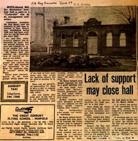
Newspaper, Lack of support may close hall, 1977
"The Mechanics Institute movement flourished in Victoria from 1839 to 1950. It was based on the development of Mechanics’ Institutes in Scotland and England from the 1820s, which were intended to educate and enlighten the working classes. The term ‘mechanic’ in those days meant an artisan, craftsman or working man, especially those who had moved from rural areas to work in new city factories during the Industrial Revolution. The early Institutes were usually equipped with a reading room, a library and a lecture room. Although enjoying mixed success in Britain, they contributed to the development of public education and library services. The movement was adopted more enthusiastically in the colonies. It began slowly in Victoria but its expansion after the gold rushes population influx was rapid, especially in rural areas. Every suburb and town wanted to have a Mechanics’ Institute. During the 1850s approximately forty Institutes were established, with even greater growth in the period 1860 to 1900. By 1900 there were 400 Institutes in Victoria. The establishment of a Mechanics’ Institute was often a great achievement for a local community, requiring organising committees to raise substantial funds for a building site (where this had not been granted by the Government), and the building. Once built, the committee then had to purchase books, provide a caretaker or librarian, and finance the ongoing use of and improvements to the building. ‘The history of many Institutes is a story of tremendous community effort, and often, financial difficulties’. In addition to being monuments to local enterprise and community life, the Mechanics’ Institutes played a vital role as an intellectual forum, and in contributing to an informed and participatory democracy in the late nineteenth and early twentieth centuries. They provided journals and other reading matter on local, state, national and international issues, and hosted of lectures and held debates about wider issues such as Federation, colonial nationalism, defence, female suffrage, the price of land and labour. With the development of the school and technical education in the latter part of the nineteenth century, the need for community technical and adult education declined. As a result of the introduction of government library grants in 1867, many Mechanics’ Institutes incorporated a free library in their buildings to finance collection of their books. By 1884-85, there were 257 free libraries in Victoria. However, government support and library grants dropped off in the 1890s depression. Entertainment took on a greater role in the 1890s, with the introduction of moving pictures, billiards rooms, games rooms (chess), concerts and dances. The First World War had a devastating impact on many rural communities, and some Mechanics’ Institutes were no longer viable. On the other hand the early twentieth century was also a time of agricultural development, and many country towns were growing in this period. The 1930s depression further limited growth of many libraries and reduced grants substantially. In response many Mechanics’ Institutes were renamed, for example as memorial halls, in order to retain and attract more patrons (eg at nearby Sunbury). The diminishing role for Mechanics’ Institutes and the preference for larger and better appointed halls (with supper rooms, cloak rooms etc) resulted in demolition of some small Institutes. The advent of cars, radios, and television also provided other opportunities for recreation, learning and entertainment. The greater role of municipalities in providing library services also eroded the need for free libraries. While over 500 Mechanics’ Institutes or halls are extant, very few of these retain their original role as ‘diffusers of useful knowledge’. Most are still available for community purposes, as venues for meetings, socials, civic occasions etc, while others are employed as museums, shops and theatres. Most buildings are on Crown land, and managed by a delegated committee of management, who are responsible for raising revenue to maintain aging buildings. Many of those which were originally established on private land, such as Melton, have since reverted back to the Crown, and municipal Councils. The most common Mechanics Institute building form is the simple weatherboard gable building with iron roofs, notable for their ‘honest simplicity’ rather than as ‘monuments of the ancients’. At the other extreme there are some magnificent two storeyed brick and stucco structures with elaborate ornamentation (as was apparently envisaged by some in Melton in 1905-10)". The future of Melton Mechanic Institute Gazette articlelocal architecture -
 Melton City Libraries
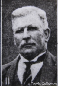
Photograph, Charles Ernest Barrie, Unknown
This document is has been compiled by Wendy Barrie daughter of Ernest (Bon) and Edna Barrie and granddaughter of Charles E and Jessie M Barrie. Ernie Barrie operated a travelling Chaff Cutter in the St Arnaud area where his parents William and Mary Ann had taken up land at Coonooer West in 1873. Ernie commenced his working life with a team of bullocks and a chaff cutter. The earliest connection he had with Melton was in 1887. By the beginning of the 20th century Ernie and his father William and brothers, William, Samuel, James Edwin,[Ted] Robert, Arthur and Albert have been associated with farming and milling in the Melton district. In the early 1900’s Ernie and his brother Ted were in partnership in a Chaff cutting and Hay processing Mill on the corner of Station and Brooklyn road Melton South. The mill was managed by William for a time. By 1906 Charles Ernest and James Edwin were in partnership in the Station Road mill when a connecting rail line across Brooklyn Road for a siding was constructed to the Melton Railway Station. In 1911 the Mill’s letterhead shows C.E. BARRIE Hay Pressing and Chaff Cutting Mills. Melton Railway Station. Telephone No 1 Melton. This Mill as sold to H S K Ward in 1916 and stood until 1977 when it burnt down in a spectacular fire. Ernie built a house at Melton South beside the Chaff Mill at Station Road in 1906 and married Jessie May Lang in August at the Methodist Church. Jessie’s father was Thomas Lang. He came to Melton in 1896 and was the Head Teacher at Melton State School No 430 until he retired in 1917. They had 9 children with 8 surviving to adulthood. Jessie and Ernie had 6 sons and 3 daughters. All the children lived at Darlingsford. In April 1910 the family left Melton for a brief period and moved to a farm in Trundle in NSW. They returned to Melton and purchased Darlingsford in May 1911. For a time during WW1 they lived at Moonee Ponds near the Lang grandparents at Ascot Vale. Mary and Bon attended Bank St State School. The children developed diphtheria in 1916 and their youngest boy, Cecil died of complications. Mary and Bon were taken to Fairfield Hospital and both recovered. At the end of the war influenza broke out the family returned to Darlingsford and shared the home for a short while with the Pearcey family who had been working the farm. By 1922 the family had and grown and Edgar, Tom, Horace, Jessie, Joyce and Jim were living a Darlingsford. Ernie continued during the 1920’s working the farm and attend his many civic and community commitments. Two 8 clydesdale horse teams were used to work the land which meant early rising for the horses to be fed and harnessed to commence the days work. In 1916 Ernie also became involved in a Chaff Mill on the corner of Sunshine and Geelong Road West Footscray, which at the time was being run by John Ralph Schutt. It was known an Schutt Barrie. A flour mill was added at a later stage. Other Schutt and Barrie mills were situated at Parwan and Diggers Rest. Another mill was situated beside the railway line at Rockbank. The Footscray mill ceased operation in 1968 Ernie spent a lot of time and energy at the Parwan Mill and travelling around Parwan and Balliang farms, where he came to know many of the families in the district. Ernies commitment to the civic development to the Melton and district was extensive, he was involved with a number of large events during the 1920’s such as the Melton Exhibitions and the 1929 Back to Melton Celebrations. He was a member of the Australian Natives Association at the turn of the century. He was Chairman of the School Committee at Melton State School 430 and the Melton South State School in thw1920s. He donated the land for a Hall for Melton South in 1909, known as Exford Hall and later in 1919 renamed Victoria Hall. The Hall was demolished in 1992. He was a Councillor, JP, and Vice President and President of the Melton Mechanics Institute Hall Committee in 1915- 1916. He was a member of the Methodist Church and later the Scots Presbyterian Church. He was Superintendent of the Sunday School of the Methodist Church to 1910 and later Scots Presbyterian Church until 1931. This is reflected in the theme of children in the stained glass window which was dedicated in his memory by his wife Jessie as a gift to the Scots Church. Charles Ernest Barrie made many generous donations to many charities who supported young people and children. In 1918 Jessie and Ernie made the first donation to a very prominent Victorian charity whose work still continues. Yooralla. In July 1931 Ernie’s untimely death was a major blow to the family and the Melton community. To this day people still vividly recall the day they lined the streets for his funeral. The day of the funeral is recalled as the day Melton stood as two of their prominent citizens who tragically died on the same dayPhotograph of Charles Ernest Barrie taken from Scenes at Melton and Old Residentslocal identities -
 Kilmore Historical Society
Photograph, Mobil Garage, 2006
Previously Mobil Garage owned by Danny and Pat D'Elia until 2001. Then demolished in 2006.15cm x 10cm colour photograph of the corner of Lancefield Road and Sydney Street. Printed on matte photographic paper (Kodak brand) Recent demolished building with rubble piled up and green security fencing around the perimeter of the property. Sign for the Willowmavin Estate is visible advertising land sales. Multiple photographs with multiple views available.Printed on back: Development information: Premier service station, construction sites -
 Kilmore Historical Society
Photograph, Mobil Garage, 2007
Previously Mobil Garage owned by Danny and Pat D'Elia until 2001. Then demolished in 2006.15cm x 10cm colour photograph of the corner of Lancefield Road and Sydney Street. Printed on matte photographic paper (Kodak brand) Recent demolished building with rubble piled up and green security fencing around the perimeter of the property. Sign for the Willowmavin Estate is visible advertising land sales. Multiple photographs with multiple views available.Printed on the back: Development information: PREMIER service stations, construction sites -
 Melton City Libraries
Photograph, Charles Ernest Barrie and family, 1906
Photograph was taken on the 23rd of August 1906, the day of Jessie May Lang and Charles Ernest Barrie's wedding. Held at the Methodist Church Melton. UMMARY – Charles Ernest Barrie d.1931 Born 1871 Ballarat d 1931 This document is has been compiled by Wendy Barrie daughter of Ernest (Bon) and Edna Barrie and granddaughter of Charles E and Jessie M Barrie. My grandfather was well known in the district and was mostly referred to as Ernie. He shared the same initials as his second son Edgar. His three eldest sons lived and farmed in Melton for their entire lives. His descendants are still associated with farming, engineering and earthmoving in Melton. Ernie Barrie operated a travelling Chaff Cutter in the St Arnaud area where his parents William and Mary Ann had taken up land at Coonooer West in 1873. Ernie commenced his working life with a team of bullocks and a chaff cutter. The earliest connection he had with Melton was in 1887. By the beginning of the 20th century Ernie and his father William and brothers, William, Samuel, James Edwin,[Ted] Robert, Arthur and Albert have been associated with farming and milling in the Melton district. In the early 1900’s Ernie and his brother Ted were in partnership in a Chaff cutting and Hay processing Mill on the corner of Station and Brooklyn road Melton South. The mill was managed by William for a time. By 1906 Charles Ernest and James Edwin were in partnership in the Station Road mill when a connecting rail line across Brooklyn Road for a siding was constructed to the Melton Railway Station. In 1911 the Mill’s letterhead shows C.E. BARRIE Hay Pressing and Chaff Cutting Mills. Melton Railway Station. Telephone No 1 Melton. This Mill as sold to H S K Ward in 1916 and stood until 1977 when it burnt down in a spectacular fire. Ernie built a house at Melton South beside the Chaff Mill at Station Road in 1906 and married Jessie May Lang in August at the Methodist Church. Jessie’s father was Thomas Lang. He came to Melton in 1896 and was the Head Teacher at Melton State School No 430 until he retired in 1917. They had 9 children with 8 surviving to adulthood. Jessie and Ernie had 6 sons and 3 daughters. All the children lived at Darlingsford. In April 1910 the family left Melton for a brief period and moved to a farm in Trundle in NSW. They returned to Melton and purchased Darlingsford in May 1911. For a time during WW1 they lived at Moonee Ponds near the Lang grandparents at Ascot Vale. Mary and Bon attended Bank St State School. The children developed diphtheria in 1916 and their youngest boy, Cecil died of complications. Mary and Bon were taken to Fairfield Hospital and both recovered. At the end of the war influenza broke out the family returned to Darlingsford and shared the home for a short while with the Pearcey family who had been working the farm. By 1922 the family had and grown and Edgar, Tom, Horace, Jessie, Joyce and Jim were living a Darlingsford. Ernie continued during the 1920’s working the farm and attend his many civic and community commitments. Two 8 clydesdale horse teams were used to work the land which meant early rising for the horses to be fed and harnessed to commence the days work. In 1916 Ernie also became involved in a Chaff Mill on the corner of Sunshine and Geelong Road West Footscray, which at the time was being run by John Ralph Schutt. It was known an Schutt Barrie. A flour mill was added at a later stage. Other Schutt and Barrie mills were situated at Parwan and Diggers Rest. Another mill was situated beside the railway line at Rockbank. The Footscray mill ceased operation in 1968. Ernie spent a lot of time and energy at the Parwan Mill and travelling around Parwan and Balliang farms, where he came to know many of the families in the district. Ernies commitment to the civic development to the Melton and district was extensive, he was involved with a number of large events during the 1920’s such as the Melton Exhibitions and the 1929 Back to Melton Celebrations. He was a member of the Australian Natives Association at the turn of the century. He was Chairman of the School Committee at Melton State School 430 and the Melton South State School in thw1920s. He donated the land for a Hall for Melton South in 1909, known as Exford Hall and later in 1919 renamed Victoria Hall. The Hall was demolished in 1992. He was a Councillor, JP, and Vice President and President of the Melton Mechanics Institute Hall Committee in 1915- 1916. He was a member of the Methodist Church and later the Scots Presbyterian Church. He was Superintendent of the Sunday School of the Methodist Church to 1910 and later Scots Presbyterian Church until 1931. This is reflected in the theme of children in the stained glass window which was dedicated in his memory by his wife Jessie as a gift to the Scots Church. Charles Ernest Barrie made many generous donations to many charities who supported young people and children. In 1918 Jessie and Ernie made the first donation to a very prominent Victorian charity whose work still continues. Yooralla. In July 1931 Ernie’s untimely death was a major blow to the family and the Melton community. To this day people still vividly recall the day they lined the streets for his funeral. The day of the funeral is recalled as the day Melton stood as two of their prominent citizens who tragically died on the same day. Charles Ernest Barrie with his parents and brothers at the front of the mill house in Melton Southlocal identities -
 Melton City Libraries
Photograph, Charles Ernest and Jessie Barrie with family, Unknown
This document is has been compiled by Wendy Barrie daughter of Ernest (Bon) and Edna Barrie and granddaughter of Charles E and Jessie M Barrie. I was born in during WW 11 and the first child of my generation to live on the ‘ Darlingsford’ property at Melton. My grandfather was well known in the district and was mostly referred to as Ernie. He shared the same initials as his second son Edgar. His three eldest sons lived and farmed in Melton for their entire lives. His descendants are still associated with farming, engineering and earthmoving in Melton. Ernie Barrie operated a travelling Chaff Cutter in the St Arnaud area where his parents William and Mary Ann had taken up land at Coonooer West in 1873. Ernie commenced his working life with a team of bullocks and a chaff cutter. The earliest connection he had with Melton was in 1887. By the beginning of the 20th century Ernie and his father William and brothers, William, Samuel, James Edwin,[Ted] Robert, Arthur and Albert have been associated with farming and milling in the Melton district. In the early 1900’s Ernie and his brother Ted were in partnership in a Chaff cutting and Hay processing Mill on the corner of Station and Brooklyn road Melton South. The mill was managed by William for a time. By 1906 Charles Ernest and James Edwin were in partnership in the Station Road mill when a connecting rail line across Brooklyn Road for a siding was constructed to the Melton Railway Station. In 1911 the Mill’s letterhead shows C.E. BARRIE Hay Pressing and Chaff Cutting Mills. Melton Railway Station. Telephone No 1 Melton. This Mill as sold to H S K Ward in 1916 and stood until 1977 when it burnt down in a spectacular fire. Ernie built a house at Melton South beside the Chaff Mill at Station Road in 1906 and married Jessie May Lang in August at the Methodist Church. Jessie’s father was Thomas Lang. He came to Melton in 1896 and was the Head Teacher at Melton State School No 430 until he retired in 1917. They had 9 children with 8 surviving to adulthood. Jessie and Ernie had 6 sons and 3 daughters. All the children lived at Darlingsford. In April 1910 the family left Melton for a brief period and moved to a farm in Trundle in NSW. They returned to Melton and purchased Darlingsford in May 1911. For a time during WW1 they lived at Moonee Ponds near the Lang grandparents at Ascot Vale. Mary and Bon attended Bank St State School. The children developed diphtheria in 1916 and their youngest boy, Cecil died of complications. Mary and Bon were taken to Fairfield Hospital and both recovered. At the end of the war influenza broke out the family returned to Darlingsford and shared the home for a short while with the Pearcey family who had been working the farm. By 1922 the family had and grown and Edgar, Tom, Horace, Jessie, Joyce and Jim were living a Darlingsford. Ernie continued during the 1920’s working the farm and attend his many civic and community commitments. Two 8 clydesdale horse teams were used to work the land which meant early rising for the horses to be fed and harnessed to commence the days work. In 1916 Ernie also became involved in a Chaff Mill on the corner of Sunshine and Geelong Road West Footscray, which at the time was being run by John Ralph Schutt. It was known an Schutt Barrie. A flour mill was added at a later stage. Other Schutt and Barrie mills were situated at Parwan and Diggers Rest. Another mill was situated beside the railway line at Rockbank. The Footscray mill ceased operation in 1968 Ernie spent a lot of time and energy at the Parwan Mill and travelling around Parwan and Balliang farms, where he came to know many of the families in the district. Ernies commitment to the civic development to the Melton and district was extensive, he was involved with a number of large events during the 1920’s such as the Melton Exhibitions and the 1929 Back to Melton Celebrations. He was a member of the Australian Natives Association at the turn of the century. He was Chairman of the School Committee at Melton State School 430 and the Melton South State School in thw1920s. He donated the land for a Hall for Melton South in 1909, known as Exford Hall and later in 1919 renamed Victoria Hall. The Hall was demolished in 1992. He was a Councillor, JP, and Vice President and President of the Melton Mechanics Institute Hall Committee in 1915- 1916. He was a member of the Methodist Church and later the Scots Presbyterian Church. He was Superintendent of the Sunday School of the Methodist Church to 1910 and later Scots Presbyterian Church until 1931. This is reflected in the theme of children in the stained glass window which was dedicated in his memory by his wife Jessie as a gift to the Scots Church. Charles Ernest Barrie made many generous donations to many charities who supported young people and children. In 1918 Jessie and Ernie made the first donation to a very prominent Victorian charity whose work still continues. Yooralla. In July 1931 Ernie’s untimely death was a major blow to the family and the Melton community. To this day people still vividly recall the day they lined the streets for his funeral. The day of the funeral is recalled as the day Melton stood as two of their prominent citizens who tragically died on the same day. Their eldest daughter Mary had married Keith Robinson in 1930 and had just moved to Heatherdale Toolern Vale with their year old baby son. Bon the eldest son was 22, Edgar 18, Tom 16, Horace 15, Jessie and Joyce 10 and Jim 8 years old. A heavy burden of responsibility fell on the shoulders of the two eldest children, Mary particularly for her mother and Bon stepped in assuming head of the family for his mother, brothers and sisters living at the Darlingsford homestead. In the early 1930’s the three eldest sons took on many of the Civic and Church commitments which their father had held. This community involvement extended well into the 1980s. In 1941 Bon married Edna Myers and they moved into a house shifted from Harkness Lane to Harkness Lane on the eastern section of the Darlingford property. Edgar married Margaret Hodgkinson a Primary school teacher at Melton in 1949 and they lived in the Darlingsford house. Earlier Tom married May Ferris and lived on the eastern side of Ferris Lane in the Ferris home. Bon , Edgar and Tom often operated as a team effort, in particular at harvest time when a larger team of workers was needed. The three farms cultivated wheat, barley and oats and supplied the Mill with sheafed hay. They continued using horse teams until mechanisation in the 1940’s made the horses redundant. By the 1960s their five sons continued with farming. Many loads of hay were transported to the Mill in Footscray. Well into the 1960s hired harvest hands along with agricultural university students were involved in bringing in he harvest. Stacking was an art form in itself and Tom held the expertise for building and shaping the sides and roof. The stacks built in the district each had their own unique shape and could be recognized by their builders. The Barrie brothers developed a mechanical fork lift for picking up complete stooks and moving them to be loaded to the elevator to build the haystack. The prototype built by Bill Gillespie was attached to a Bedford truck. Later refinements in a collaborative effort with the Gillespie brothers a multi pronged fork was attached to the front of tractor which was hydraulically operated to raise each stook onto trucks to be transported to the site of the haystacks. This method of handling sheaves significantly reduced laborious pitchforking individual sheaves. This invention was soon taken up by farmers far and wide and was a common sight in the district at harvest time in the stacking season. I recall visiting farmers calling in at the house at Ferris Road farm to inspect this break through invention. The Clydesdale horse teams were used into the 1940s but by the 1950s the Barries’ farms were fully mechanised. When the demand for sheafed hay declined other crops were introduced these included barley, lucerne, wheat and peas. Sheep were added to the mix in the 1950s in an attempt to keep the farms more viable. In the 1970s part of the Barrie’s farms were facing a major disruption with the impending compulsorily acquisition of a strip of land for the construction the freeway bypass, which divided access between the Darlingsford homestead with those on Ferris Lane. Charles Ernest Barrie and Jessie May Lang's children: 1. Mary Ena BARRIE was born on 07 October 1907. She died on 29 April 1999. 2. Ernest Wesley BARRIE was born on 29 April 1909 in Ascot Vale, Victoria, Australia.He died on 25 December 1985 in Melton, Victoria, Australia. 3. Cecil William BARRIE was born on 23 February 1911.He died on 25 May 1916. 4. Charles Edgar BARRIE was born on 01 June 1913.He died on 06 October 1975. 5. Thomas Lindsay BARRIE was born on 25 November 1914.He died on 14 September 1990 in Melton, Victoria, Australia. 6. William Horace BARRIE was born on 11 October 1915.He died on 19 December 1950. 7. Jessie Maud BARRIE was born on 06 November 1920 in Bacchus Marsh, Victoria, Australia.She died on 26 February 1994. 8. Dorothy Joyce BARRIE was born on 06 November 1920 in Bacchus Marsh, Victoria, Australia.She died on 18 March 2003.. 9. James Edward BARRIE was born on 17 January 1922 in Bacchus Marsh, Victoria, Australia.He died on 23 August 2004Family Photo with Edgar, Tom, Mary, Ernest (Bon), Horace, Jim, Charles Ernest, Jessie and Joycelocal identities -
 Melton City Libraries
Document, Minns Family Reunion, 2004
"A perpetual spring in the adjacent creek provided a steady supply of fresh water to the site on which the homestead is built. Although we can not be certain of the identity of the builder, the first stage of ‘The Willows’ homestead appears to have been constructed in the mid 1850s. The house is situated on Crown Allotment No.1 (No Section), Parish of Kororoit, an allotment of 5 acres 3 roods 4 perches. Although it had surveyed the land, the Crown did not offer it for sale until 22nd November 1861, at which time it was purchased by Charles March Williams. (Although the property is directly opposite and immediately adjacent to the Township of Melton, and was sold as ‘Suburban Allotment 33’, it was situated within the Shire of Braybrook rather than the Shire of Melton until 1917.) Considerable improvements had taken place on the land prior to the Crown sale. When CM Williams purchased the allotment in November 1861 he paid £23.5.0 for the land itself, and valued the improvements at £400. Even allowing for some exaggeration by Williams, this is an extremely high valuation for improvements, and must have included a house. Some local research has claimed that in 1858 Williams had taken over the interest of a Mr Parkinson in the property, and that Parkinson built the house upon taking possession of the land c.1855. It was definitely built by 1861, when a map shows a square building on the site marked as ‘House’. The property is important in the district for its association with the establishment of the pound. The district pound had been established in 1854, when George Scarborough of Mount Cottrell (Mt Cottrell Road, south of Greigs Road) was appointed pound-keeper. Scarborough resigned in 1857. The pound was moved to Melton following agitation from local farmers and Charles March Williams appointed pound-keeper on 26th April 1858. Williams, the son of a doctor, had been born in London. Reminiscences of local residents of the time, as recorded in the Express newspaper, note Williams’ success in breeding horses on the property. Sales of up to 60 guineas were noted. Whether this was from Williams’s own stock or from unclaimed pound stock is not made clear. Williams appeared before a government inquiry in 1860 and advocated registration of all stock brands in the State. Williams died in 1862 leaving a widow, Catherine, and five living children aged 15 years to five months. At the time of his death Williams had entered negotiations with one Matthew Devenish and had a mortgage of £100 on allotments 1 and 2, Parish of Kororoit. Catherine Williams was appointed pound-keeper on 2 September 1863, with her eldest son Charles as her assistant. Her tenure was short for on 22nd March 1864 George Minns senior paid Matthew Devenish £135 for allotments 1 and 2 Parish of Kororoit (considerably less than Williams had claimed the property was worth in 1861) and on the same day paid William Tullidge £45 for the adjoining allotments 3 and 4. In April 1867, James Ebden Minns, the newly married son of George senior became the owner of The Willows property having entered into a mortgage arrangement with his father to the extent of £200. At the time George Minns was residing in Kaarimba having left Melton in 1867 for a short trip to England and upon his return having taken up a selection in the Kaarimba district with his son Frederick who had a hotel licence there. James paid out the mortgage on 2-1-1873. James Minns was appointed pound-keeper in 1872; in 1885 the pound was moved elsewhere and Minns purchased the old pound site and added it to his farm. The Willows residence underwent a major change about this time. A two room extension, similar in style but with a lower elevation was added to the original rear of the house with a chimney matching the distinctive originals. Window arrangements did not match the original but became a feature of the façade when the new addition became the front of the building. Six buttresses were attached to the east and west walls of the old building, two to the south wall and the whole rendered with mortar to give the appearance of dressed stonework around the windows. Galvanized iron was placed over the shingles and a verandah added on three sides. By 1876 The Willows was the homestead for a thriving mixed farm of 340 acres of which 156 was rented from a H. Ruck. In October of that year the Australasian travelling reporter visited and reported on the property. In common with the nearly every other property in the district the farm had ‘recently’ (generally within the last two years) abandoned cultivation of crops, and turned over completely to cattle pasture. Butter making was the principal occupation of the farm, which had about 50 head of cattle, a large proportion of which were milking cows. The reporter also noted that a ‘large number of pigs are kept upon this farm and are found to be very profitable stock’. Their manure was used in an orchard and garden in which ‘large quantities of lucerne and prairie grass are grown for the use of stock when ordinary feed is scarce’. Two bores attached to deep brick lined wells supplied water for the house in addition to the farm. A commodious timber barn and necessary sheds had also been constructed. Access to the property was improved following the construction of the bluestone ford across the creek c.1887, when the recreation ground came into use. Prior to this date it may have been that the crossing referred to as ‘Mr Minns bridge’ was used. This appears to have been a flimsy structure and has but two references in Council reports in the Melton Express in the 1880’s. It is believed that in the late 1890’s a timber building was added near the rear of the building to house a kitchen, ablutions and laundry rooms and rooms for seasonal workers. This was attached to the house by means of a trellised walkway using the original front entry to the house (long since the back door). A photograph of this building appears in a local history of Melton. This was demolished in recent decades during the period when the house was tenanted (after the Minns family had left). James Minns son, George, took over the property following his marriage to Alice Walsh in 1903. James and Caroline moved into a house on the former JH Games property at the eastern end of Henry Street. George held the position of Shire Secretary for Melton for 40 years. He was a most prominent member of the community being Secretary to, among others, the Melton Coursing Club, the Shooting Club and the Cemetery Trust. He also rode with the hunting parties who sported across the Plains and were entertained at Mount Kororoit. George and Alice had one son, Norman who followed his father into local government and became Secretary of the Shire of Werribee completing a record term in this position. George retired to Werribee in 1951, where he died in 1965. The National Trust records note that James Ebden Minns and his sons were ‘leading men of the district, Justices of the Peace, and Shire Councillors’. It claims that Sir Thomas Bent was a frequent visitor. The Willows passed into the hands of George’s grandson, Bruce Minns and the property was let for a number of years. In the 1960s it became vacant and was subject to vandalism. Major structural problems arose with the part demolition of the roof, the loss of windows and doors and holes dug into and under the floorboards. The outbuildings were particularly targeted. Following widespread public support, the Shire of Melton purchased the house, with 3.75 acres of land, in 1972. In 1975 the Shire of Melton and the Melton and District Historical Society were successful in nominating the building for National Trust classification, and then the Australian Heritage Commission’s Register of the National Estate. The AHC particularly noted its ‘townscape importance’. It was envisaged that the farmhouse would form ‘a picturesque centrepiece to Melton’s planned … historical park, along with Dunvegan bluestone cottage … and similar structures as they become available.’ In a time of great Melton’s ‘satellite city’ development the Council spelt out its broader vision in its submission to the AHC: ‘Melton is destined to become, by the end of the present century, a city of between 75,000 and 100,000 people. Significant relics of the past, such as ‘The Willows’, regrettably will be rare in that situation. It is essential that sufficient tangible links with Melton’s pioneering days remain to promote in the new community a sense of history and continuity’. Under the direction of ‘The Willows’ Restoration Committee and consultant architect John Hitch, all outbuildings, with the exception of the garage and toilet, were demolished and the dwelling house restored. Finances were provided by the Shire of Melton and the National Estate Grants Program, and considerable amount of voluntary labour was provided by the local community. The orchard was removed, and remaining wooden buildings were relocated to provide an open vista for visitors to the Park. The property was furnished with donations from district families keen to preserve this example of pioneer life in the area. The Willows became the headquarters of the Melton and District Historical Society". Invitation to the family reunion at the Willowslocal identities, pioneer families -
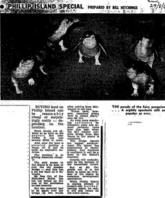 Phillip Island Conservation Society Inc.
Work on paper - Photocopy of newspaper cutting, Melbourne Sun newspaper, "PHILLIP ISLAND SPECIAL PREPARED BY BILL HITCHINGS", 29.08.1969
This article by journalist Bill Hitchings describes the state of the land market and cost of transporting building materials, Phillip Island, late 1960s. At that stage a number of outlying residential estates had been created, especially on Phillip Island South Coast and at Cowes West. While blocks of land on the outlier estates were very cheap and poorly serviced, the Cowes blocks were selling at $3000 per residential block. Hitchings quotes the owner of the Hollydene motel, Reg Orr, as saying that when the new bridge opens shortly he did not expect it to create a rush of visitors or residents.Bill Hitching was a well-known Melbourne journalist. This article gives an idea of land values on Phillip Island in the late 1960s, the fact that business owners were prepared to upgrade and expand their businesses to cater for extra potential demand on accommodation, and the strong identification of Phillip Island with the Phillip Island Penguin Parade in the minds of the general public in Melbourne. The significance of the new Phillip Island bridge to Phillip Islanders and visitors, and the cost of the bridge, are also outlined. Reg Orr was highly active in the business community of that era on Phillip Island. The Hollydene motel was a well-known Phillip Island accommodation venue.T-shaped article cutting with large image at top of article, dark due to poor photcopy. Double collumn text under photo clearly readable. Black and white.Sun/29/8/6 (?) Probably: Melbourne Sun newspaper, 29 August, 1969phillip island, phillip island tourism, development, hollydene motel, reg orr, phillip island penguin parade, land values, phillip island first bridge, phillip island 2nd bridge, transportation costs -
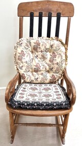 Wodonga & District Historical Society Inc
Furniture - Haeusler Family Rocking chair
The Wodonga Historical Society Haeusler Collection provides invaluable insight into life in late nineteenth and early twentieth century north east Victoria. The collection comprises manuscripts, personal artefacts used by the Haeusler family on their farm in Wodonga, and a set of glass negatives which offer a unique visual snapshot of the domestic and social lives of the Haeusler family and local Wodonga community. The Haeusler family migrated from Prussia (Germany) to South Australia in the 1840s and 1850s, before purchasing 100 acres of Crown Land made available under the Victorian Lands Act 1862 (also known as ‘Duffy’s Land Act’) in 1866 in what is now Wodonga West. The Haeusler family were one of several German families to migrate from South Australia to Wodonga in the 1860s. The Collection also depicts development of life in Wodonga through the eyes of one family, through a collection of artefacts, diaries, letters and photographs. This item is from the Hauseler Collection which documents social life of early settlers in the Wodonga community.An old wooden rocking chair, The chair was originally home manufactured from timber. The back slats have been repaired and replaced by metal slats attached at the top and base of the backrest section.early settlement wodonga, haeusler family of wodonga -
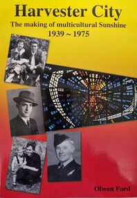 Wodonga & District Historical Society Inc
Book - Harvester City - The Making of Multicultural Sunshine 1939 - 1975, Olwen Ford, Published 2012
This publication by the Sunshine & District Historical Society builds on an earlier publication "Harvester Town: The Making of Sunshine 1890-1925". It focuses on the post-war migration years when thousands of young immigrants settled in the new City of Sunshine, bought land, built homes, had families and worked in the area's important industries. It uses a range of primary resources including photos, photo stories, interviews and other documents to explain the challenges, achievements and issues faced in the development of "Multicultural Sunshine"A soft cover publication of 590 pages. The cover features several photos of people and places in Sunshine, The background of these cover photos is coloured in yellow and orange. The book includes photos and photo stories as well as extracts from newspapers, government archives and census records to document key developments and stories of hardships and achievements during a critical period of industrialisation and postwar migration to Australia. It includes bibliographical references and an index.non-fictionThis publication by the Sunshine & District Historical Society builds on an earlier publication "Harvester Town: The Making of Sunshine 1890-1925". It focuses on the post-war migration years when thousands of young immigrants settled in the new City of Sunshine, bought land, built homes, had families and worked in the area's important industries. It uses a range of primary resources including photos, photo stories, interviews and other documents to explain the challenges, achievements and issues faced in the development of "Multicultural Sunshine"multiculturalism australia, , sunshine victoria, postwar migration -
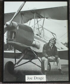 Wodonga & District Historical Society Inc
Photograph - Joe Drage and his Tiger Moth, Rob Elliott, 1993
This image is one from a series of portraits taken by Rob Elliott to record the character of the Border District through the faces if its identities. Born on 10 July 1931 in Walwa, Joseph Gordon (Joe) Drage operated a timber mill and earthmoving business, but his great passion was aviation. After obtaining his pilot’s licence at the age of 19, Mr. Drage set about buying vintage aircraft that he feared would be sold overseas. He bought his first aircraft, a Tiger Moth in 1965. In 1972 he established Drage Historical Aircraft Museum on about 60 ha of land in Wodonga, with 5 planes. Over time this grew to 21 planes which Joe maintained so that they were all in flying order. His museum was the location for several air shows which included fly-ins by members of the Antique Aeroplane Association. The land occupied by the Museum was compulsorily acquired by the Albury-Wodonga Development Corporation and Wangaratta council bought the aircraft collection for about $2 million. They opened Drage Airworld in 1984. The cost of maintaining the collection became too much for the council which closed it down in 2002. Joe Drage died on 9 August 2017.This portrait depicts a person who made a significant contribution to the Wodonga community.A portrait of Joe Drage sitting on the wheel of his Tigermoth. The photo has been mounted in a metal frame.joe drage airworld, aircraft museum wodonga, joe drage -
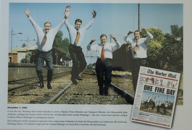 Wodonga & District Historical Society Inc
Photograph - One Fine Day - decision to move Wodonga Railway Line, 2000
On December 1, 2000 it was finally announced that the railway line would be moved away from the centre of the Wodonga CBD after many years of lobbying. Since its opening in 1873 the railway line had crossed High Street, originally called Sydney Road. The railway had bisected the city with level crossing gates frequently stopping the flow of traffic as trains passed through. The Wodonga Rail Bypass project moved Wodonga station from the original central location to a position on a new line on the northern edge of the town. Not only did this release land in the middle of the city for commercial and public use, but also eliminated 10 level crossings. The project actually commenced in 2008 with the last passenger train passing through Wodonga on 8 November 2008. On 23 July 2010, the new rail bypass was opened, and the original line through Wodonga closed. In this image the decision is celebrated by the Member for Indi, the Honourable Lou Lieberman, Deputy Prime Minister and Transport Minister John Anderson, Wodonga Mayor Cr. Graham Crapp and General Manager of Uncle Ben's Australia, Mr Bob Kennedy.This image commemorates a significant occasion in the development of the Central Business District of Wodonga, Victoria.A framed photo of four men celebrating the decision to move the railway out of the centre of Wodonga as well as an image of the from page of the Border Mail newspaper.wodonga railway, wodonga rail bypass, city of wodonga -
 Wodonga & District Historical Society Inc
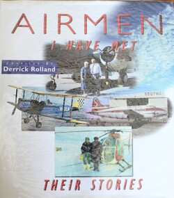
Book - Airmen I have Met - Their Stories, Derrick Rolland, 1999
This book includes biographies of 16 different airmen with whom the compiler has come in contact. They have had their own uniques experiences in aviation. 12 of them served in the Royal Australian Air Force (RAAF). One of the aviators featured in this publication is Joe Drage, Born on 10 July 1931 in Walwa, Joseph Gordon (Joe) Drage operated a timber mill and earthmoving business, but his great passion was aviation. After obtaining his pilot’s licence at the age of 19, Mr. Drage set about buying vintage aircraft that he feared would be sold overseas. He bought his first aircraft, a Tiger Moth in 1965. In 1972 he established Drage Historical Aircraft Museum on about 60 ha of land in Wodonga, with 5 planes. Over time this grew to 21 planes which Joe maintained so that they were all in flying order. His museum was the location for several air shows which included fly-ins by members of the Antique Aeroplane Association. The land occupied by the Museum was compulsorily acquired by the Albury-Wodonga Development Corporation and Wangaratta council bought the aircraft collection for about $2 million. They opened Drage Airworld in 1984. The cost of maintaining the collection became too much for the council which closed it down in 2002. Joe Drage died on 9 August 2017.This publication has a hard cover with a dust jacket. It consists of 191 pages, including 85 black and white and 12 coloured images.This book includes biographies of 16 different airmen with whom the compiler has come in contact. They have had their own uniques experiences in aviation. 12 of them served in the Royal Australian Air Force (RAAF). One of the aviators featured in this publication is Joe Drage, Born on 10 July 1931 in Walwa, Joseph Gordon (Joe) Drage operated a timber mill and earthmoving business, but his great passion was aviation. After obtaining his pilot’s licence at the age of 19, Mr. Drage set about buying vintage aircraft that he feared would be sold overseas. He bought his first aircraft, a Tiger Moth in 1965. In 1972 he established Drage Historical Aircraft Museum on about 60 ha of land in Wodonga, with 5 planes. Over time this grew to 21 planes which Joe maintained so that they were all in flying order. His museum was the location for several air shows which included fly-ins by members of the Antique Aeroplane Association. The land occupied by the Museum was compulsorily acquired by the Albury-Wodonga Development Corporation and Wangaratta council bought the aircraft collection for about $2 million. They opened Drage Airworld in 1984. The cost of maintaining the collection became too much for the council which closed it down in 2002. Joe Drage died on 9 August 2017.air pilots australia, aviation history, joe drage, joe drage airworld -
 Wodonga & District Historical Society Inc
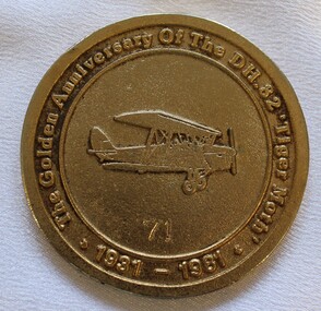
Medal - Antique Aeroplane Association Wodonga Air Show Medallion, 1981
This medallion was produced to commemorate the Antique Aeroplane Association of Australia's annual air show which was held at Wodonga in 1981. It took place at Joe Drage's Air World Museum in Wodonga, Victoria. It recognised the 50th anniversary of the manufacture of the first De Haviland 82 Tiger Moth in 1931. This medallion and 2 other linked medallions were owned by Mr. Clive Cossor. He spent a lot of time at Drage's Historical Aircraft Museum and also helped transport gliders. He was also at the Albury racecourse as a teenager to assist in moving the Uiver when it was forced to land in a storm during the MacRobertson Trophy Air Race from London to Melbourne in October 1934.This medallion is significant as it records an important event recognising aviation in Australia and recognises the development of the Tiger Moth aircraft.A medallion produced to commemorate the Antique Aeroplane Association of Australia's annual air show held at Wodonga in 1981On the front around the medallion surrounding an image of a Tiger Moth aircraft: "The Golden Anniversary of the DH. 82 "Tiger Moth" 1931-1981" Numbered 71 On reverse around the edge: "Antique Aeroplane Association of Australia/ WODONGA 1981". In the centre: "SPONSORS/2AY/ALBURY-WODONGA"aviation history, antique aeroplane association of australia, joe drage airworld, airshow wodonga, dh tiger moth -
 Wodonga & District Historical Society Inc
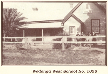
Photograph - Wodonga West School No. 1058
Wodonga West School opened on 24 January 1870 and closed on 9 May 1950. It was located near the current intersection of McKoy Street and the Hume Freeway in West Wodonga on land donated by J.W. Klinge. The school replaced an older school, “Green Hills School, which was located north of the railway line. A public telephone was installed at the school and the mail service operated from the school three days each week. In 1935 a row of 15 ornamental trees was planted along the boundary fence, one for each of the pupils at the school. When this school closed the nine remaining students were transferred to Wodonga Primary School.This image is significant because it documents the early developments in the provision of education in Wodonga, Victoria A black and white photo of a group of children standing outside the Wodonga West School building.wodonga schools, wodonga west primary school, education wodonga -
 Wodonga & District Historical Society Inc
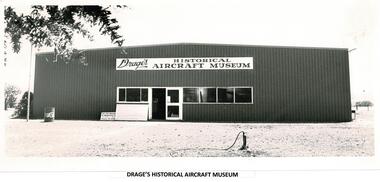
Photograph - Drage's Historical Aircraft Museum, Wodonga
Born on 10 July 1931 in Walwa, Joseph Gordon (Joe) Drage operated a timber mill and earthmoving business, but his great passion was aviation. After obtaining his pilot’s licence at the age of 19, Mr. Drage set about buying vintage aircraft that he feared would be sold overseas. He bought his first aircraft, a Tiger Moth in 1965. In 1972 he established Drage Historical Aircraft Museum on about 60 ha of land in Wodonga, with 5 planes. Over time this grew to 21 planes which Joe maintained so that they were all in flying order. His museum was the location for several air shows which included fly-ins by members of the Antique Aeroplane Association. The land occupied by the Museum was compulsorily acquired by the Albury-Wodonga Development Corporation and Wangaratta council bought the aircraft collection for about $2 million. They opened Drage Airworld in 1984. The cost of maintaining the collection became too much for the council which closed it down in 2002. Joe Drage died on 9 August 2017.This image is significant because it depicts a popular Wodonga business which brought many people to the region over more than a decade.A black and white photo of building used as aircraft museum in Wodongaaircraft museum wodonga, joe drage, joe drage airworld -
 Wodonga & District Historical Society Inc
Photograph - Kenneth Darnton Watson - Community Leader
Kenneth Darnton Watson was born at Bendigo on 24 May 1893 to George Darnton Watson and Adelaide Nora Holmes. He was educated at Melbourne Church of England Grammar School, being selected as School Captain in 1913 and a member of the Head of the River rowing team. After finishing school, he worked as a jackaroo on Wanganella Station and later at Mt. Widderin, Skipton, Victoria. When WW1 was declared, Kenneth enlisted and after initial training at Maribyrnong, Victoria he left Australia as 2nd Lieutenant with 7th Australian Field Artillery Brigade, to disembark at Plymouth on July 10, 1916. He took part in the Battles of Messines, Menin Road, Polygon Wood and Passchendaele Ridge in 1917. For his efforts in Passchendaele Ridge on 17th December he was awarded the Military Cross "for conspicuous gallantry and devotion to duty." In 1918 he took part in the Battles of Villers-Bretonneux, Hamel and Amiens. He returned to Australia in November 1919 and was discharged on 20th January 1920. In 1922, Kenneth Darnton Watson came to Wodonga where he purchased de Kerilleau, consisting of 2,500 acres, from Mr George Gordon. The two storey brick homestead had been built by William Huon in 1870. On 30th May 1924, he married Phyllis Emily Lenore Austin and they had four children, Ian Darnton 1925, Robert Darnton 1926 Rosemary McPherson 1929 and Faith Holmes 1931. On the land he worked hard, building fences, cattle, sheep and horse yards, and farmed Corriedale sheep, Shorthorn cattle and horses. Mr Watson was an innovative farmer, introducing modern methods of top dressing at de Kerilleau by means of an aircraft. He was also a dedicated community man. He was a member of both Albury and Wodonga Show Committees, Murray Valley Development League, No.1 Region, Graziers' Association of Southern Riverina, Albury Legacy Club, Wodonga RSL, and Wodonga Turf Club including terms as President on several of these organisations. Kenneth was also a Warden of St. Luke's Church of England, Wodonga. Kenneth served as Wodonga Shire President from 1929 to 1931, and was again elected to Council from 1943 to 1945. A most respected and valued member of the local community, Kenneth Darnton Watson died on the 4th of October 1951, aged 58. Lenore Watson lived at de Kerilleau until her death on 15th June 1984. Both are buried in Wodonga.These images are significant because they record the service of a prominent member of the Wodonga community.A collection of black of white images of Kenneth Darnton Watson of Wodonga.kenneth darnton watson, watson family wodonga, wodonga community members -
 Wodonga & District Historical Society Inc
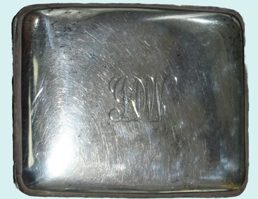
Functional object - Cigarette Case - K. D. Watson, Wodonga
This cigarette case was owned by Kenneth Darnton Watson and carried into battle during World War I. Kenneth Darnton Watson was born at Bendigo on 24 May 1893 to George Darnton Watson and Adelaide Nora Holmes. He was educated at Melbourne Church of England Grammar School, being selected as School Captain in 1913 and a member of the Head of the River rowing team. After finishing school, he worked as a jackaroo on Wanganella Station and later at Mt. Widderin, Skipton, Victoria. When WWI was declared, Kenneth enlisted and after initial training at Maribyrnong, Victoria he left Australia as 2nd Lieutenant with 7th Australian Field Artillery Brigade, to disembark at Plymouth on July 10, 1916. He took part in the Battles of Messines, Menin Road, Polygon Wood and Passchendaele Ridge in 1917. For his efforts in Passchendaele Ridge on 17th December he was awarded the Military Cross "for conspicuous gallantry and devotion to duty." In 1918 he took part in the Battles of Villers-Bretonneux, Hamel and Amiens. He returned to Australia in November 1919 and was discharged on 20th January 1920. In 1922, Kenneth Darnton Watson came to Wodonga where he purchased de Kerilleau, consisting of 2,500 acres, from Mr George Gordon. The two storey brick homestead had been built by William Huon in 1870. On 30th May 1924, he married Phyllis Emily Lenore Austin and they had four children, Ian Darnton 1925, Robert Darnton 1926 Rosemary McPherson 1929 and Faith Holmes 1931. On the land he worked hard, building fences, cattle, sheep and horse yards, and farmed Corriedale sheep, Shorthorn cattle and horses. Mr Watson was an innovative farmer, introducing modern methods of top dressing at de Kerilleau by means of an aircraft. He was also a dedicated community man. He was a member of both Albury and Wodonga Show Committees, Murray Valley Development League, No.1 Region, Graziers' Association of Southern Riverina, Albury Legacy Club, Wodonga RSL, and Wodonga Turf Club including terms as President on several of these organisations. Kenneth was also a Warden of St. Luke's Church of England, Wodonga. Kenneth served as Wodonga Shire President from 1929 to 1931, and was again elected to Council from 1943 to 1945. A most respected and valued member of the local community, Kenneth Darnton Watson died on the 4th of October 1951, aged 58. Lenore Watson lived at de Kerilleau until her death on 15th June 1984. Both are buried in Wodonga.This item is significant because it was owned by a decorated Australian serviceman and prominent member of the Wodonga community.A silver cigarette case owned by Kenneth Darnton Watson of Wodonga. The inside contains straps to hold the cigarettes in place. Both the front and back have been engraved.On front: KDW On back: 1919kenneth darnton watson, watson family wodonga, wodonga community members -
 Wodonga & District Historical Society Inc
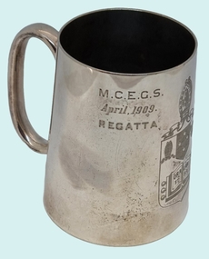
Functional object - Silver Mug - K. D. Watson, Wodonga
This cup was awarded to Kenneth Darnton Watson when he was a boarder and competitive rower whilst completing his secondary education. Kenneth Darnton Watson was born at Bendigo on 24 May 1893 to George Darnton Watson and Adelaide Nora Holmes. He was educated at Melbourne Church of England Grammar School, being selected as School Captain in 1913 and a member of the Head of the River rowing team. After finishing school, he worked as a jackaroo on Wanganella Station and later at Mt. Widderin, Skipton, Victoria. When WW1 was declared, Kenneth enlisted and after initial training at Maribyrnong, Victoria he left Australia as 2nd Lieutenant with 7th Australian Field Artillery Brigade, to disembark at Plymouth on July 10, 1916. He took part in the Battles of Messines, Menin Road, Polygon Wood and Passchendaele Ridge in 1917. For his efforts in Passchendaele Ridge on 17th December he was awarded the Military Cross "for conspicuous gallantry and devotion to duty." In 1918 he took part in the Battles of Villers-Bretonneux, Hamel and Amiens. He returned to Australia in November 1919 and was discharged on 20th January 1920. In 1922, Kenneth Darnton Watson came to Wodonga where he purchased de Kerilleau Homestead, consisting of 2,500 acres, from Mr George Gordon. The two storey brick homestead had been built by William Huon in 1870. On 30th May 1924, he married Phyllis Emily Lenore Austin and they had four children, Ian Darnton 1925, Robert Darnton 1926 Rosemary McPherson 1929 and Faith Holmes 1931. On the land Kenneth worked hard, building fences, cattle, sheep and horse yards, and farmed Corriedale sheep, Shorthorn cattle and horses. he was an innovative farmer, introducing modern methods of top dressing at de Kerilleau by means of an aircraft. He was also a dedicated community man. He was a member of both Albury and Wodonga Show Committees, Murray Valley Development League, No.1 Region, Graziers' Association of Southern Riverina, Albury Legacy Club, Wodonga RSL, and Wodonga Turf Club including terms as President on several of these organisations. Kenneth was also a Warden of St. Luke's Church of England, Wodonga. Kenneth served as Wodonga Shire President from 1929 to 1931, and was again elected to Council from 1943 to 1945. A most respected and valued member of the local community, Kenneth Darnton Watson died on the 4th of October 1951, aged 58. Lenore Watson lived at de Kerilleau until her death on 15th June 1984. Both are buried in Wodonga.These images are significant because they record the service of a prominent member of the Wodonga community.A silver mug awarded to K D Watson as a rowing trophy in April 1909. It features the shield of Melbourne Church of England Grammar School (M.C.E.G.S.), as well as his name and the event for which it was awarded.View 1: M.C.E.G.S. April 1909 Regatta View 2: Crest of MECEGS featuring motto "Ora et Labora" View 3: BOARDERS FOUR K. D. WATSON 3kenneth darnton watson, watson family wodonga, wodonga community members -
 Wodonga & District Historical Society Inc
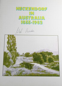
Book - Heckendorf in Australia 1855 - 1982
A Genealogical study of the Families of Frederick Heckendorf and a Record of Their Descendants, 1808-1982, 127 Years in Australia. In 1855, Frederick and Julianna Heckendorf and their children departed Hamburg on the SS Steinwarder for a new life in Australia. In 1869, they moved to Wodonga and it wasn't long before they set up a dairy farm at Willow Park. One hundred years later, the farm was in the hands of Fredrick's great grandson Les Boyes. In the 1970s the land was acquired by the Albury-Wodonga Development Corporation, which had the goal of developing Albury-Wodonga into a major inland city.non-fictionA Genealogical study of the Families of Frederick Heckendorf and a Record of Their Descendants, 1808-1982, 127 Years in Australia. In 1855, Frederick and Julianna Heckendorf and their children departed Hamburg on the SS Steinwarder for a new life in Australia. In 1869, they moved to Wodonga and it wasn't long before they set up a dairy farm at Willow Park. One hundred years later, the farm was in the hands of Fredrick's great grandson Les Boyes. In the 1970s the land was acquired by the Albury-Wodonga Development Corporation, which had the goal of developing Albury-Wodonga into a major inland city.heckendorf family, wodonga pioneers, german migration to australia