Showing 3626 items
matching landscape
-
 Glen Eira Historical Society
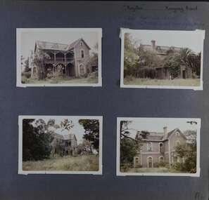
Album - Album page, Royston, Kooyong Road, Circa 1972
This photograph is part of the Caulfield Historical Album 1972. This album was created in approximately 1972 as part of a project by the Caulfield Historical Society to assist in identifying buildings worthy of preservation. The album is related to a Survey the Caulfield Historical Society developed in collaboration with the National Trust of Australia (Victoria) and Caulfield City Council to identify historic buildings within the City of Caulfield that warranted the protection of a National Trust Classification. Principal photographer thought to be Trevor Hart, member of Caulfield Historical Society. Most photographs were taken between 1966-1972 with a small number of photographs being older and from unknown sources. All photographs are black and white except where stated, with 386 photographs over 198 pages. Vol 1 of 4 "Caulfield's Heritage" p34 states that this mansion was demolished in 1972.Page 114 of Photograph Album with four colour photographs (landscape) of different views of Royston in its garden.Handwritten: "Royston" Kooyong Road / 240 KOOYONG ROAD / 1939 - SLATTER - MISS MAY EDITH ALICE. [top right] / 114 [bottom right]trevor hart, caulfield north, kooyong road, 1860's, villa residence, victorian, mansion, ornamented corner stones, royston, renwick, curved windows, timber verandahs, return verandahs, bay windows, may edith alice slatter, may slatter, balconies, polychrome bricks, abandoned buildings -
 Glen Eira Historical Society
Album - Album page, Labassa, 4 Manor Grove, Circa 1972
This photograph is part of the Caulfield Historical Album 1972. This album was created in approximately 1972 as part of a project by the Caulfield Historical Society to assist in identifying buildings worthy of preservation. The album is related to a Survey the Caulfield Historical Society developed in collaboration with the National Trust of Australia (Victoria) and Caulfield City Council to identify historic buildings within the City of Caulfield that warranted the protection of a National Trust Classification. Principal photographer thought to be Trevor Hart, member of Caulfield Historical Society. Most photographs were taken between 1966-1972 with a small number of photographs being older and from unknown sources. All photographs are black and white except where stated, with 386 photographs over 198 pages. HISTORY:-- From Victorian Heritage Database citation for Labassa https://vhd.heritagecouncil.vic.gov.au/places/278 as at (26/10/2020) Labassa, Caulfield is one of Melbourne's most lavishly decorated nineteenth century mansions. It resulted from the extensive remodelling in 1890, of an earlier house, known as Sylliott Hill, which was begun in 1862-3 for lawyer, Richard A. Billing. The land at the corner of Balaclava and Orrong Roads was first acquired in 1854 by William Lyall, transferred to his partner, John Mickle, in 1859, who also acquired the adjoining allotment in Balaclava Road, and the three allotments were conveyed to Billing. His first eight-roomed house was extended significantly in 1873 into a twenty-roomed house by architects Crouch and Wilson, who were possibly also responsible for the first house. This reflected Billing's success as a barrister, and he resided at this property until his death in 1882. In 1883 prominent Melbourne businessman, Alexander William Robertson, leased the Sylliott Hill property from Billing's widow, and in 1885 he purchased the adjoining allotment in Balaclava Road. He purchased the Billing's property in 1887 and renamed the 6.31 hectare property, Ontario. In 1889-90, Robertson commissioned the German born architect, John A. B. Koch, to extensively remodel the house into a thirty-five roomed mansion. The existing house was extended and altered, largely resulting in the nineteenth century mansion as it now appears. After Robertson's death in 1896, the house was tenanted until it was eventually sold to the mining millionaire, John Boyd Watson, in 1904. He renamed the property Labassa and carried out repair and re-decoration work to the house. In the early twentieth century, many large estates were subdivided into smaller allotments as the demand for land grew and it became difficult to maintain such large estates. After Watson's death in 1911, portions of the Labassa estate were offered for sale, with Mrs Watson retaining a 1.73 hectare portion containing the house. In 1913 forty-six allotments were auctioned at Labassa Estate, with the formation of Labassa Grove and Ontario Street to the east of the property. Labassa was first recorded as containing flats in 1923 and in the late 1920s, the owner, Robert Hannon, built a red brick block of flats adjacent to the house. Subdivision continued, until the National Trust of Australia (Victoria) purchased the house in 1980 and subsequently purchased adjoining sites, one to the south-east in 1984 (house demolished in 1988) and to the west in 1988. Labassa as it now stands is substantially as it appeared when Koch completed the work in 1890. The original two storey house was transformed into a French Renaissance style mansion, with the addition of a two level L-shaped arcaded verandah and two prominent terminating bays to the south and the east. The building is of unpainted cement render with dressed bluestone plinths, balustraded parapet and steep, slate covered, flat topped mansard roofs behind. A truncated conical roof is a feature of the south bay and a helmeted head is incorporated in the parapet over the east bay. The main south and east facades incorporate many cast cement details, including sculptures, elaborate cornices, swagged Corinthian columns and caryatid consoles flanking the entrance porch, as well as pink marble panels and imitation marble, or scagliola, on curved surfaces. At the rear of the building is a two storey wing and a single storey cottage, the former being connected to the main house by a tower. This section of the house was constructed in 1873. The estate at its peak included stables (1873), conservatory (probably 1890) and a tennis pavilion (probably 1890). All of these outbuildings survive, with the stables and conservatory being converted for residential use after 1922. Internally a range of decorative treatments remain from the late nineteenth century and the early twentieth century, both from the Robertson and Watson periods of occupancy. These include wallpapers, ceiling decoration, chimney pieces, mouldings, joinery and decorative glass.From Victorian Heritage Database citation for H0135 Labassa 2/2A Manor Grove Caulfield North https://vhd.heritagecouncil.vic.gov.au/places/278 as at (26/10/2020) HOW IS IT SIGNIFICANT? Labassa, Caulfield is of architectural, aesthetic and historical significance to the State of Victoria. WHY IS IT SIGNIFICANT? Labassa, Caulfield is of architectural significance as the most prominent example of a small number of houses built in Australia in the French Renaissance style. It is of further note due to the German interpretation of the style and the use of Hellenistic sources, via Germany. It is exceptional for its lavish treatment externally, including marble, scagliola, caryatids, swagged columns, mansard roofs and ornamental cresting. Labassa is of architectural significance as the most important surviving example of German architect, John Koch's domestic work. He undertook a large variety of work in Melbourne, including a number of houses, however Labassa is the most lavish example of his work. Labassa is of aesthetic significance for its outstanding assemblage of late nineteenth and early twentieth century European style interior decoration, which remain remarkably intact. These include a trompe l'oeil ceiling, painted ceilings, embossed imitation leather and other papers, chimney pieces, ceramic tilework, oak parquetry and stained glass, including a tripartite window by Ferguson and Urie, probably dating from the 1873 period. Labassa is of historical significance as an illustrative example of the wealth acquired by a number of prominent Victorian families in the second half of the 19th century. The early development of the property, Sylliott Hill, was due to the wealth acquired by Richard Billing, barrister and fifth Victorian to be appointed Queen's Counsel in 1878. The significant development in 1890 of Ontario, is illustrative of the wealth of Alexander Robertson, a partner in Cobb and Co., a director of Goldsborough Mort & Co., and a pastoral speculator. John B. Watson, whose father had acquired great wealth from the goldfields of Bendigo and subsequently invested in city and country properties, was the third resident to impact on the house, particularly the interiors. The Labassa estate is of historical significance as an illustrative example of the development that occurred in such suburbs as Caulfield in the 1880s due to the land boom, its proximity to Melbourne and the establishment of the Melbourne to Gippsland railway in 1879. It is also illustrative of an estate which succumbed to the pressures of subdividing in the early twentieth century, as properties became difficult to maintain and demand for land close to the city grew. It was typically divided into flats in the 1920s and was used as such for about sixty years. It is of historical significance for its associations with the remnants of the earlier estate which remain extant. These include the stables, conservatory (H2005) and tennis pavilion which all remain on separate sites. Also significant are the remains of early electrical wiring and fittings. Labassa was one of the first houses in Caulfield to be electrified and some of the original wires remain. [Online Data Upgrade Project 2004]Page 129 of Photograph Album with three landscape photographs of Labassa. One of the photographs is of Labassa's drive and gates.Handwritten: 4 JUNE 1910 / SALE JUNE 28 1910 "LA BASSA' / "AUSTRALASIAN" FORMERLY "ONTARIO"/ RES OF JOHN B WATSON / 15 ACRES 3 ROADS [under bottom left photo] / 4 JUNE 1910 [under bottom right photo] / 129 [bottom left]trevor hart, bracketed eaves, intricate lacework, slate roof, bay windows, decorative brackets, caulfield north, labassa, richard a. billing, balaclava road, orrong road, sylliott hill, william lyall, crouch and wilson, alexander william robertson, ontario, 1880's, john a. b. koch, mansion, john boyd watson, labassa grove, french renaissance style, l-shaped arcaded verandah, bluestone plinths, balustraded parapet, flat topped mansard roofs, conical roof, elaborate cornices, corinthian columns, caryatid consoles, marble panels, imitation marble, scagliola, tower, conservatory, stables, tennis pavilion, mouldings, decorative glass, caryatids, swagged columns, ornamental cresting, trompe l'oeil ceiling, embossed imitation leather, oak parquetry, stained glass, tripartite window, triple window, ferguson and urie, 1870's, flats, 1920's, electric wiring, 1860's, verandahs, curved windows, arched windows, italianate, terraces, gargoyles, ornamentation, ornate entrance, la bassa, manor grove, st kilda east, gates, cast iron work, richard billing, architects, john koch, electrification, victorian style, drives, john mickle, land subdivision, mrs watson, labassa estate, robert hannon, national trust of australia (victoria), sculpture -
 Glen Eira Historical Society
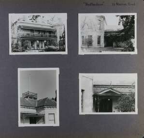
Album - Album page, Heatherbrae, 73 Neerim Road, Circa 1972
This photograph is part of the Caulfield Historical Album 1972. This album was created in approximately 1972 as part of a project by the Caulfield Historical Society to assist in identifying buildings worthy of preservation. The album is related to a Survey the Caulfield Historical Society developed in collaboration with the National Trust of Australia (Victoria) and Caulfield City Council to identify historic buildings within the City of Caulfield that warranted the protection of a National Trust Classification. Principal photographer thought to be Trevor Hart, member of Caulfield Historical Society. Most photographs were taken between 1966-1972 with a small number of photographs being older and from unknown sources. All photographs are black and white except where stated, with 386 photographs over 198 pages.From Victorian Heritage Database citation for Heatherbrae HO46 https://vhd.heritagecouncil.vic.gov.au/places/120933 (as at 28/10/2020) "Heatherbrae" at 73 Neerim Road, Glenhuntly, is a substantial Victorian residential complex made up of two principal construction stages (pre 1876 and c. 1890) and outbuildings including stables. It is aesthetically, historically and socially significant. Its aesthetic value is demonstrated by the manner in which the two periods of construction survive, the earliest being of greater architectural interest on account of its tower and facade treatment, the latter phase adopting a common villa form. The importance of the complex is heightened by its intact state and surviving outbuildings. "Heatherbrae's" historical significance lies in its link with locally known business man and Shire of Caulfield councillor, John Charles Holland. Its social value rests on its ability to demonstrate a past lifestyle.Page 142 of Photograph Album with four photographs (three landscape, one portrait) of Heatherbrae on Neerim Road.Handwritten: "Heatherbrae" 73 Neerim Road [top right] / 142 [bottom right]trevor hart, verandah, chimneys, decorative brackets, cast iron columns, return verandah, garden, 1870's, intricate lacework, neerim road, booran road, 1880's, 1890's, mansion, john c. holland, bluestone foundations, italianate, iron roofed balcony, cast iron balustrade, balcony, ornamented pediment, mosaic tiles, cast iron lookout, flagpole, george f griffiths, mcgowan, tower, caulfield, heatherbrae, cast iron work, victorian style, john holland, porte-cochere porches, lead lights, george griffiths, mansions, stables, councillors, outbuildings -
 Glen Eira Historical Society
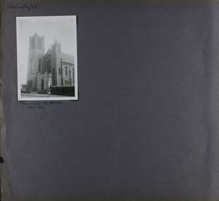
Album - Album page, Glen Huntly Road, Circa 1972
This photograph is part of the Caulfield Historical Album 1972. This album was created in approximately 1972 as part of a project by the Caulfield Historical Society to assist in identifying buildings worthy of preservation. The album is related to a Survey the Caulfield Historical Society developed in collaboration with the National Trust of Australia (Victoria) and Caulfield City Council to identify historic buildings within the City of Caulfield that warranted the protection of a National Trust Classification. Principal photographer thought to be Trevor Hart, member of Caulfield Historical Society. Most photographs were taken between 1966-1972 with a small number of photographs being older and from unknown sources. All photographs are black and white except where stated, with 386 photographs over 198 pages. From: Glen Eira Heritage Management Plan (1996) by Andrew Ward and Associates This Area is marked by the imposing brick and freestone gothic Revival church of the Holy Cross, built in 1937 to the design of O.H. Jorgensen. Church of the Holy Cross and Presbytery are contributory buildings to HO66.Page 65 of Photograph Album with one exterior photograph (landscape) of a brick church with a three storey tower.Hand written: Glenhuntly Rd [top left] / HOLY CROSS RC CHURCH / Dec 1972 [written underneath the photo] / 65 [bottom left] trevor hart, 1930's, gothic revival, brick, bell tower, spire, facade, catholic church, o h jorgensen, holy cross catholic church, caulfield, glenhuntly road, caulfield south, presbytery -
 Glen Eira Historical Society
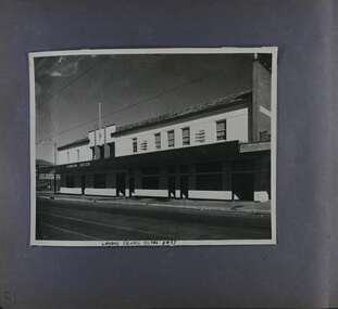
Album - Album page, London Tavern, Hawthorn Road, Circa 1972
This photograph is part of the Caulfield Historical Album 1972. This album was created in approximately 1972 as part of a project by the Caulfield Historical Society to assist in identifying buildings worthy of preservation. The album is related to a Survey the Caulfield Historical Society developed in collaboration with the National Trust of Australia (Victoria) and Caulfield City Council to identify historic buildings within the City of Caulfield that warranted the protection of a National Trust Classification. Principal photographer thought to be Trevor Hart, member of Caulfield Historical Society. Most photographs were taken between 1966-1972 with a small number of photographs being older and from unknown sources. All photographs are black and white except where stated, with 386 photographs over 198 pages. Glen Eira Heritage Management Plan 1996 by Andrew Ward The 1857 rate book indicates that the major portion of the District was under pasture, although a considerable portion was cultivated. There were 159 houses, huts and tents whose occupants were mainly occupied on the land. If "Camden Town" was the principal commercial focus for the District in 1857, it was to remain so in later years, incorporated today in the Glenhuntly Road centre which extends more or less continuously from Elsternwick to Bambra Road. The Caulfield State School of 1877, the horse tramway of 1889 and subsequently the electric trams were all events confirming the importance of Glenhuntly Road and the fledgling community of "Camden Town" wherein the City's commercial centre has its origins. It is recalled, today, by their presence, and also by the "London Tavern" in Hawthorn Road, established by John Guess in 1873. Dr Geulah Solomon's 4 volume book "Caulfield's Heritage" Vol 1 p 93: "A modern hotel presently on the site continues the name of the London Tavern." That was true until recent years as the hotel is named The Camden Hotel now (2021).Page 81 of Photograph Album with one landscape photograph of the front of the London Tavern with handwriting on the edge of the photograph.Hand written: LONDON TAVERN HOTEL 1937 [on bottom edge of photo] / 81 [bottom left] trevor hart, caulfield, hawthorn road, london tavern, camden town, john guess, hotels, pubs, victorian, 1870's, 1930's, sycamore street, the camden hotel -
 Glen Eira Historical Society
Album - Album page, Ripponlea, Hotham Street, Circa 1972
This photograph is part of the Caulfield Historical Album 1972. This album was created in approximately 1972 as part of a project by the Caulfield Historical Society to assist in identifying buildings worthy of preservation. The album is related to a Survey the Caulfield Historical Society developed in collaboration with the National Trust of Australia (Victoria) and Caulfield City Council to identify historic buildings within the City of Caulfield that warranted the protection of a National Trust Classification. Principal photographer thought to be Trevor Hart, member of Caulfield Historical Society. Most photographs were taken between 1966-1972 with a small number of photographs being older and from unknown sources. All photographs are black and white except where stated, with 386 photographs over 198 pages.From Victorian Heritage Database citation for Rippon Lea H0614 https://vhd.heritagecouncil.vic.gov.au/places/427(as at 23/10/2020) Rippon Lea was commenced in 1868 by Frederick Sargood, a most successful politician and merchant. He was born in England in 1834 and arrived in Melbourne in 1850. He soon joined his father's wholesale soft goods firm, spending some time as its manager on the goldfields. Sargood entered the Legislative Council in 1874. He was Victoria?s first Minister for Defence in 1883. Sir Frederick Sargood was created CMG. In 1885 and KCMG in 1890 as a reward for his contribution to public life. He died suddenly in 1903. Rippon Lea was designed by the leading firm of architects, Reed and Barnes. Joseph Reed had travelled in Europe in 1863, including northern Italy. When he returned he introduced the use of polychromy. While not the first examples, Rippon Lea and the Independent Church in Collins Street were the best and set a fashion which became a distinctly Melbourne style, particularly used for houses and churches. Its popularity was possible because of the new availability of different coloured bricks. Reed's fine Lombardic Romanesque details soon became debased by others. As Sargood's family grew and his fortunes prospered, Rippon Lea was extended to include 33 rooms - a complete mansion. The cast iron porte cochere and the northern conservatory were added in 1897. The architects were Taylor and Fitts. The ballroom was added in 1882 and remodelled in 1889. Many alterations have changed the interior and exterior during the ownerships of Benjamin Nathan and later his daughter Mrs Louisa Jones in the 1930s and are in their own right of significance. Sir Thomas Bent owned the property from 1903 until 1911 but never lived there. He subdivided much of the land. The original garden dates from about 1868, and it seems that William Guilfoyle of the Botanic Gardens was involved. It was redesigned in a more natural style in the 1880s by Sargood and his head gardener, Adam Anderson. The lake, waterfalls, fernery, hill and grotto are balanced by mighty deciduous trees and conifers. These are interspersed with, but never dominated by Australian species such as eucalyptus and other exotics. The sinuous drive with its carefully prepared approach to the house is notable. The original vegetable gardens, orchard and outer paddocks no longer survive. The shade house is important as the largest known in Australia and possibly the world. Its curved plan and form of construction are particularly notable. It was built about 1884.Page 93 of Photograph Album with four photographs (two landscape and two portrait) of Ripponlea - lake and gardens.Handwritten: Neg 239 Dec 1973 LAKE [under top left photo] / Neg 242 Dec 1973 FERN HOUSE [under top right photo] / Neg 243 Dec 1972 FERN HOUSE [under bottom left photo] / Neg 241 Dec 1972 LAKE [under bottom right photo] / 93 [bottom left]trevor hart, elsternwick, mansion, hotham street, frederick sargood, sargood, reed and barnes, 1860's, 1890's, 1880's, benjamin nathan, nathan, louisa jones, thomas bent, sir thomas bent, william guilfoyle, adam anderson, lake, grotto, shade house, portico, ripponlea, victorian, sir frederick sargood, architects, taylor and fitts, rippon lea, gardens, ferns, bridges, walking trails -
 Federation University Historical Collection
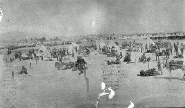
Photograph - black and white, Harry Holmes, Australian Soldiers Breaking Camp at Metras, c1916
The postcard was sent by Harry Holmes who was a member of the Australian Imperial Force based in Egypt at the time. He sent a number of postcards home to his family in Ascot, Victoria. Egypt was a major base for the AIF from December 1914. A number of campaigns were fought in this theatre. There were two campaigns involving the AIF. Note that not all the fighting was actually geographically in Egypt. (http://www.aif.adfa.edu.au:8888/about3.html) This photograph is significant because it was taken by a soldier (rather than an official war artist) and shows one of the daya to day activities experienced by Australian Soldiers in Egypt during World War One.A number of tents and soldiers in a dry landscape. They are Australian Soldiers At Metras, Egypt during World War One. Verso: 'Breaking Camp at Metras prior to making our departure from there on March 28th.'chatham family archive, chatham, holmes, harry holmes, world war, world war 1, world war one, world war i, metras, egypt -
 Moorabbin Air Museum
Book (item) - Basic Detailed Type Specification for the Herald Four Engined Civil Transport Aircraft
-
 Benalla Art Gallery
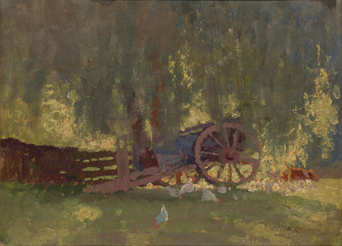
Painting, Elioth GRUNER, Summer shade, c. 1916
Born: Gisborne, New Zealand 1882; Arrived: Sydney, New South Wales, Australia 1883; Died: Sydney, New South Wales, Australia 1939Heidelberg SchoolGift of Mrs E.E. Ledger, 1975Rural farm landscape with wagon, animals and building. Gold patterned moulding with grey velvet insert frame.Recto: Signed "E. GRUNER" in black paint in l.r.c of composition; Not dated; Not titledpainting, rural, wagon, chicken, animals, wheel, fence, trees, farm, australian art -
 Benalla Art Gallery
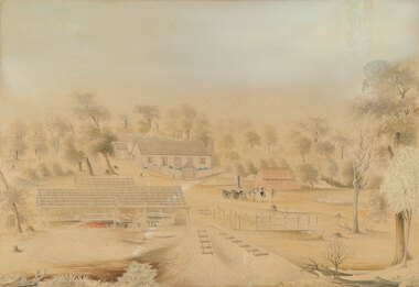
Watercolour, William TIBBITS, Mr J. Thompson's star sawmills, Staffordshire Reef, Not dated
Born: 1837; Arrived Australia c. 1866; Died: Sydney, New South Wales, Australia 1906ColonialLedger Gift, 1982Rural landscape with farmhouse and outbuildings surrounded by trees, two figures by a horse and wagon. Stained wooden frame.Recto: Signed "Drawn by W.TIBBITS. artist NEIL ST. Ballarat" in blue ink in lower centre of sheet edge; Titled 'Mr J.Thompson’s. / Star Saw Mills Staffordshire Reef.' in blue ink in lower centre of sheet; Not datedwatercolour, colonial, rural, trees, buildings, wheels, horse, animal -
 Hume City Civic Collection
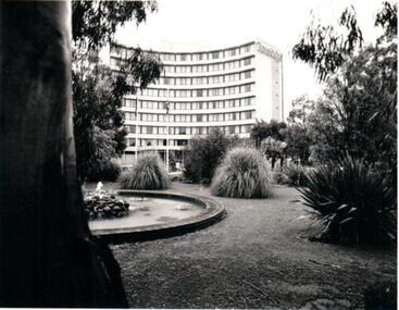
Photograph, c.1973-74
The Melbourne Airport was built at Tullamarine in the late 1960's and officially opened in 1970. The Travel Lodge Hotel was built opposite the main terminal building to accommodate air travellers.A black and white photograph of the Travel Lodge Hotel in the Melbourne Airport complex and the landscaped gardens in front of the building.hotels, melbourne airport, tullamarine, travelodge hotel, george evans collection -
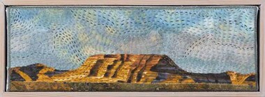 Wangaratta Art Gallery
Textile, June Brown, Storm (Sky Series), 2013
Stormy skies can be memorable with dark and contrasting colours. They often appear menacing and producing apprehension in the air because of the oncoming weather. Fabrics used in this piece are all commercial. I have endeavoured to make the sky angry with stitches. The mesa has some very dark and ominous craggy rifts. ‘Sky Series’ Changes are constantly taking place in the sky . I love the variety, colour and movement of the sky which are all a direct result of the clouds, sun and time of day. I certainly think about the sky much more when we are on Safari. The sky is a great indicator of the ever changing time of day and weather conditions …... fine and clear, cloudy, sunset, sunrise and storms. The artwork features a simple ‘mesa’ shape against the sky. A mesa is a flat topped hill. Which are part of the Australian Inland. The mesa I have featured is in recognition of Mt Connor in the Northern Territory.Wangaratta Art Gallery CollectionA embroidered textile depiction of an outback landscape scene during a storm featuring a colour palette of blues and browns.june brown, textile -
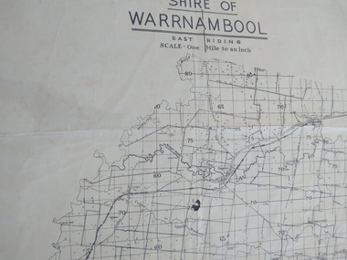 Peterborough History Group
Map - Shire of Warrnambool East Riding
Contextual location of Peterborough town within the shire at that time, including local roads.Historic informationA3 size map of the Warrnambool Shire East Riding, includes landscape details, and the location of town in the Shire.Irvine written in pencil on the backpeterborough, curdies river inlet, old maps, warrnambool shire map -
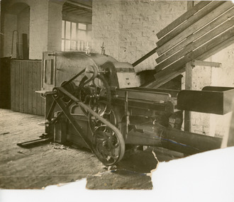
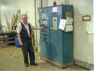 Stawell Historical Society Inc
Photograph - Aunde Album 29, Dye House, 2002
Aunde / Norwellan Textiles North Western Woolen Mills became Norwellan Textiles then AUNDEColour landscape photo: Male worker turning machine on/off - manuals on side of machine. Information on wallAUnde Australia Ltd. logoindustry, aunde -
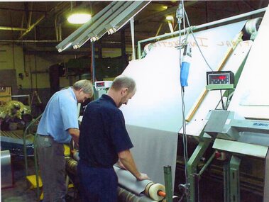
 Stawell Historical Society Inc
Photograph - Aunde Album 29, Checking finished Weave, 2002
Aunde / Norwellan Textiles North Western Woolen Mills became Norwellan Textiles then AUNDEColour landscape photo: Male employee checking finished weave as it goes on roll from weaving machine.industry, aunde -
 Stawell Historical Society Inc
Photograph - Aunde Album 29, Final Inspection, 2002
Aunde / Norwellan Textiles North Western Woolen Mills became Norwellan Textiles then AUNDEColour landscape photo: 2 men rolling material onto roll for final inspection of material for flawsFinal Inspectionindustry, aunde -
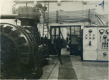
 National Wool Museum
Photograph, Carding Machine, Unknown
Photographs were most likely used for promotional purposes. The photographed machine was made by Tomlinsons (Roshdale) Limited, was British machine manufacture company based in Rochdale.Black and white photo of a Rag Puller Machine in landscape format. Location of photo looks to be in a textile mill.On machine - Tomlinsons (Roshdale) Limited.textile machinery, wool manufacture, wool, timlinsons, rag pulling -
 National Wool Museum
Photograph, Unknown
Man standing in what looks to be a wool processing factory.Black and white photo of a man surrounded by machinery in a landscape format. The photo is attached to a olive coloured board.textile machinery, wool manufacture, wool -
Whitehorse Historical Society Inc.
Article, Art Watch, 1993
Dutch folk art and oil landscapes exhibited at Wyreena Community Arts Centre in Croydon. With photo. Photocopy.shows and exhibitions, winters, tina, rogalski, barbara, wyreena community arts centre -
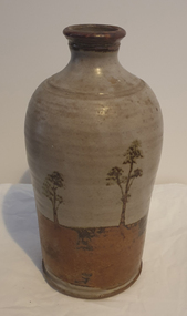 Ballarat Heritage Services
Photograph, Ceramic Bottle by Maldon Pottery
Maldon Pottery was established in 1973 by Neville Wilson (1946-1996), Tom Metcalf (1948- ) and Graham Masters (1950- ) on Barringhup Road, Maldon, Victoria. Tom Metcalf and Graham Masters Masters graduated from Bendigo College of Advanced Education all Bendigo graduates. Wilson ) He was a skilled drawer and did all the brushwork. Metcalf (1948- ) graduated in 1968, did two years' work experience at Non-porite in Melbourne, then worked as a thrower and decorator at Bendigo Pottery from 1971-73. He is T.M. on Epsom ware. Masters (1950- ) graduated in 1973 and established the Enterprise Pottery at Myers Flat with Morris Hesse in 1974, so must have joined the partnership later than the others. He left in 1984 to set up his own Sweenies Creek Pottery. Metcalf left in the late 1980s, leaving Wilson to operate the pottery by himself until his death in 1996. As well as using the Maldon Pottery stamp, Wilson signed some of his work with his name or an impressed 'N'. Photograph of a hand thrown ceramic bottle, with glaze design depicting an Australian landscape in the 'continuous trees' pattern.maldon pottery, ceramics, australian studio pottery -
Tatura Irrigation & Wartime Camps Museum
Photograph - Photograph - copy, Tatura 1945, 1945
Copy of the original painting given to Tatura Museum by Buda House at Castlemaine, Victoria. They have original hanging in the House. The painting was purchased by the owners, Leviny, who had the house for over 118 years. The painting was done by Fritz KRAMPE, an internee in Tatura during WW2.A printed copy of the original artwork. Picture of several trees and landscape at Tatura camp during 1940's. -
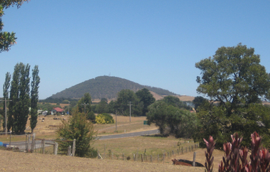 Ballarat and District Irish Association
Photograph - Colour, Clare Gervasoni, Mount Warrenheip from Bungaree, 2009, 26/01/2009
Bungaree and Warrenheip are known as early Irish settlements in the Ballarat district.A photographic landscape taken from Bungaree with Mount Warrenheip in the background. Mount Warrenheip is in close proximity to Ballarat. ballarat irish, warrenheip, mt warrenheip, bungaree -
Moorabbin Air Museum
Booklet (Item) - Short History of the Rolls-Royce Merlin Engine, A Brief History of the Birth and Development of the Merlin Aero Engine
-
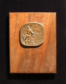 Montsalvat
Bronze Medallion/ Plaque, Untitled (Sower)
Rectangular wood plaque with bronze medallion depicting a male nude sowing seeds in a landscape with fence posts. Stamped on reverse (Lc) 'Matcham Skipper/ Montsalvat'matcham skipper, plaque, wood, bronze, medallion, sower, male nude -
University of Melbourne, Burnley Campus Archives
Plan, Burnley Student Social Garden, 1995
1 coloured and 1 black and white copy Landscape Plan by Brooke Ryan. Scale 1:50.1995brooke ryan, students, gardens, burnley -
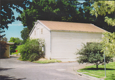 University of Melbourne, Burnley Campus Archives
Photograph - Colour print, The Dairy Shed in 1990, 1990
Appears to have been used in an exhibitionCaption, "The dairy shed in 1990, by now reclad. In the 1980's it was used for storage of landscape and arboriculture equipment."dairy shed, storage, equipment -
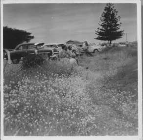 Port Fairy Historical Society Museum and Archives
Photograph, East Beach parking 1950-1960s
East Beach parking 1950-1960s looking North and upwards from the beach trackBlack and white landscape showing cars parked overlooking the East Beach with a Norfolk Island pine in the backgroundbeach, sea, seascape, east beach, norfolk island pine -
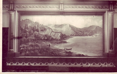 Clunes Museum
photograph, Hornby of Clunes
OLIO - STAGE CURTAIN [PHOTOGRAPH] IN CLUNES TOWN HALL.PHOTOGRAPH OF AN OLIO - STAGE CURTAIN - OIL PAINTING LANDSCAPE PART OF STAGE SET. PAINTED BY RICHARD FORDlocal history, photography, photographs, town hall, richard ford -
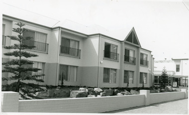 Lakes Entrance Regional Historical Society (operating as Lakes Entrance History Centre & Museum)
Photograph, Lake Post Newspaper, 1994
Black and white photograph of the new Bellevue Motel Units, with landscaping between units and front fence on the Esplanade.motels, architecture, tourism -
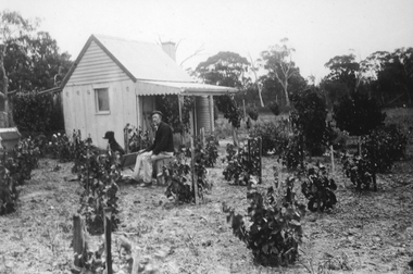 Stawell Historical Society Inc
Photograph, Mr Joseph Jennings in his garden
Joseph Jennings in his garden. Joseph Jennings is George Jennings brother. The location may be Mayo Park, Lubeck.Black and white photograph of a man sitting with his dog in front of a small timber building in a garden landscape.stawell